Best (4-layer) lifted index uses parcels from the lowest four model layers to assess stability at 500 hPa. More negative values indicate greater instability.
- Units: K.
- Often used alongside CAPE and CIN in convective forecasting.
gfs
GFS (Global Forecast System) is NOAA/NCEP's primary global numerical weather prediction model. It is a coupled system that combines atmosphere, ocean, land/soil, and sea-ice components to simulate Earth's weather in three dimensions.
The atmospheric component uses the FV3 dynamical core at approximately 0.25 degree horizontal grid spacing, about 28 km. GFS runs globally with about 127 vertical levels up to the mesopause and produces forecast output four times per day.
The gfs dataset exposed by GribStream uses the 0.25 degree global grid. Forecasts are hourly through 120 h, then every 3 hours through day 16 (384 h). Initial conditions come from the GDAS/GFS analysis system, which assimilates satellite, radar, radiosonde, surface, and other observations.
GFS is a foundation for several NOAA forecast systems. It supports the GEFS ensemble and its wave, chemistry, and aerosol variants, contributes to seasonal to subseasonal systems such as CFS, and provides boundary context for regional models such as HRRR and RAP.
Customers use GFS for global forecasting, medium-range outlooks, aviation routing, maritime navigation, environmental modeling, agricultural planning, climate downscaling, machine learning inputs, and operational backtesting. It is usually the first dataset to consider when the workflow needs global coverage and a long forecast horizon.
Click a parameter to reveal variants in a compact table with ready-to-copy JSON selectors.
Best (4-layer) lifted index uses parcels from the lowest four model layers to assess stability at 500 hPa. More negative values indicate greater instability.
| Level | Info | Horizon | Introduced | Selector |
|---|---|---|---|---|
surface |
0h-384h | 2021-03-22 |
{"name":"4LFTX","level":"surface","info":""}
|
Absolute vorticity combines relative vorticity and planetary vorticity from Earth's rotation. It highlights rotation and dynamical forcing in the flow.
| Level | Info | Horizon | Introduced | Selector |
|---|---|---|---|---|
0.01 mb |
0h-384h | 2021-03-22 |
{"name":"ABSV","level":"0.01 mb","info":""}
|
|
0.02 mb |
0h-384h | 2021-03-22 |
{"name":"ABSV","level":"0.02 mb","info":""}
|
|
0.04 mb |
0h-384h | 2021-03-22 |
{"name":"ABSV","level":"0.04 mb","info":""}
|
|
0.07 mb |
0h-384h | 2021-03-22 |
{"name":"ABSV","level":"0.07 mb","info":""}
|
|
0.1 mb |
0h-384h | 2021-03-22 |
{"name":"ABSV","level":"0.1 mb","info":""}
|
|
0.2 mb |
0h-384h | 2021-03-22 |
{"name":"ABSV","level":"0.2 mb","info":""}
|
|
0.4 mb |
0h-384h | 2021-03-22 |
{"name":"ABSV","level":"0.4 mb","info":""}
|
|
0.7 mb |
0h-384h | 2021-03-22 |
{"name":"ABSV","level":"0.7 mb","info":""}
|
|
1 mb |
0h-384h | 2021-03-22 |
{"name":"ABSV","level":"1 mb","info":""}
|
|
10 mb |
0h-384h | 2021-03-22 |
{"name":"ABSV","level":"10 mb","info":""}
|
|
100 mb |
0h-384h | 2021-03-22 |
{"name":"ABSV","level":"100 mb","info":""}
|
|
1000 mb |
0h-384h | 2021-03-22 |
{"name":"ABSV","level":"1000 mb","info":""}
|
|
15 mb |
0h-384h | 2021-03-22 |
{"name":"ABSV","level":"15 mb","info":""}
|
|
150 mb |
0h-384h | 2021-03-22 |
{"name":"ABSV","level":"150 mb","info":""}
|
|
2 mb |
0h-384h | 2021-03-22 |
{"name":"ABSV","level":"2 mb","info":""}
|
|
20 mb |
0h-384h | 2021-03-22 |
{"name":"ABSV","level":"20 mb","info":""}
|
|
200 mb |
0h-384h | 2021-03-22 |
{"name":"ABSV","level":"200 mb","info":""}
|
|
250 mb |
0h-384h | 2021-03-22 |
{"name":"ABSV","level":"250 mb","info":""}
|
|
3 mb |
0h-384h | 2021-03-22 |
{"name":"ABSV","level":"3 mb","info":""}
|
|
30 mb |
0h-384h | 2021-03-22 |
{"name":"ABSV","level":"30 mb","info":""}
|
|
300 mb |
0h-384h | 2021-03-22 |
{"name":"ABSV","level":"300 mb","info":""}
|
|
350 mb |
0h-384h | 2021-03-22 |
{"name":"ABSV","level":"350 mb","info":""}
|
|
40 mb |
0h-384h | 2021-03-22 |
{"name":"ABSV","level":"40 mb","info":""}
|
|
400 mb |
0h-384h | 2021-03-22 |
{"name":"ABSV","level":"400 mb","info":""}
|
|
450 mb |
0h-384h | 2021-03-22 |
{"name":"ABSV","level":"450 mb","info":""}
|
|
5 mb |
0h-384h | 2021-03-22 |
{"name":"ABSV","level":"5 mb","info":""}
|
|
50 mb |
0h-384h | 2021-03-22 |
{"name":"ABSV","level":"50 mb","info":""}
|
|
500 mb |
0h-384h | 2021-03-22 |
{"name":"ABSV","level":"500 mb","info":""}
|
|
550 mb |
0h-384h | 2021-03-22 |
{"name":"ABSV","level":"550 mb","info":""}
|
|
600 mb |
0h-384h | 2021-03-22 |
{"name":"ABSV","level":"600 mb","info":""}
|
|
650 mb |
0h-384h | 2021-03-22 |
{"name":"ABSV","level":"650 mb","info":""}
|
|
7 mb |
0h-384h | 2021-03-22 |
{"name":"ABSV","level":"7 mb","info":""}
|
|
70 mb |
0h-384h | 2021-03-22 |
{"name":"ABSV","level":"70 mb","info":""}
|
|
700 mb |
0h-384h | 2021-03-22 |
{"name":"ABSV","level":"700 mb","info":""}
|
|
750 mb |
0h-384h | 2021-03-22 |
{"name":"ABSV","level":"750 mb","info":""}
|
|
800 mb |
0h-384h | 2021-03-22 |
{"name":"ABSV","level":"800 mb","info":""}
|
|
850 mb |
0h-384h | 2021-03-22 |
{"name":"ABSV","level":"850 mb","info":""}
|
|
900 mb |
0h-384h | 2021-03-22 |
{"name":"ABSV","level":"900 mb","info":""}
|
|
925 mb |
0h-384h | 2021-03-22 |
{"name":"ABSV","level":"925 mb","info":""}
|
|
950 mb |
0h-384h | 2021-03-22 |
{"name":"ABSV","level":"950 mb","info":""}
|
|
975 mb |
0h-384h | 2021-03-22 |
{"name":"ABSV","level":"975 mb","info":""}
|
Convective precipitation accumulation represents precipitation produced by the convection scheme during the output period. It isolates convective rainfall from larger-scale precipitation.
| Level | Info | Horizon | Introduced | Selector |
|---|---|---|---|---|
surface |
1h-384h | 2021-03-22 |
{"name":"ACPCP","level":"surface","info":""}
|
Surface albedo is the fraction of incoming shortwave radiation reflected by the surface. Higher albedo means less solar energy absorbed and a cooler surface.
| Level | Info | Horizon | Introduced | Selector |
|---|---|---|---|---|
surface |
1h-384h | 2021-03-22 |
{"name":"ALBDO","level":"surface","info":""}
|
Accumulated precipitation represents the total water-equivalent amount of rain and snow during the output period. It is a primary field for hydrologic impacts and event totals.
| Level | Info | Horizon | Introduced | Selector |
|---|---|---|---|---|
surface |
1h-384h | 2021-03-22 |
{"name":"APCP","level":"surface","info":""}
|
Apparent temperature combines air temperature, humidity, and wind to estimate how hot or cold it feels to humans. It is useful for heat and cold stress assessments.
| Level | Info | Horizon | Introduced | Selector |
|---|---|---|---|---|
2 m above ground |
0h-384h | 2021-03-22 |
{"name":"APTMP","level":"2 m above ground","info":""}
|
Convective Available Potential Energy (CAPE) quantifies buoyant energy available to rising air parcels. Larger values generally imply stronger potential updrafts and greater convective intensity.
| Level | Info | Horizon | Introduced | Selector |
|---|---|---|---|---|
180-0 mb above ground |
0h-384h | 2021-03-22 |
{"name":"CAPE","level":"180-0 mb above ground","info":""}
|
|
255-0 mb above ground |
0h-384h | 2021-03-22 |
{"name":"CAPE","level":"255-0 mb above ground","info":""}
|
|
90-0 mb above ground |
0h-384h | 2021-03-22 |
{"name":"CAPE","level":"90-0 mb above ground","info":""}
|
|
surface |
0h-384h | 2021-03-22 |
{"name":"CAPE","level":"surface","info":""}
|
Categorical indicator of freezing rain occurrence at the surface during the output period.
| Level | Info | Horizon | Introduced | Selector |
|---|---|---|---|---|
surface |
0h-384h | 2021-03-22 |
{"name":"CFRZR","level":"surface","info":""}
|
Categorical indicator of ice pellet (sleet) occurrence at the surface during the output period.
| Level | Info | Horizon | Introduced | Selector |
|---|---|---|---|---|
surface |
0h-384h | 2021-03-22 |
{"name":"CICEP","level":"surface","info":""}
|
Convective Inhibition (CIN) measures the energy barrier that must be overcome to initiate convection. More negative values indicate a stronger cap that can suppress storms.
| Level | Info | Horizon | Introduced | Selector |
|---|---|---|---|---|
180-0 mb above ground |
0h-384h | 2021-03-22 |
{"name":"CIN","level":"180-0 mb above ground","info":""}
|
|
255-0 mb above ground |
0h-384h | 2021-03-22 |
{"name":"CIN","level":"255-0 mb above ground","info":""}
|
|
90-0 mb above ground |
0h-384h | 2021-03-22 |
{"name":"CIN","level":"90-0 mb above ground","info":""}
|
|
surface |
0h-384h | 2021-03-22 |
{"name":"CIN","level":"surface","info":""}
|
Cloud water mixing ratio is the mass of liquid cloud droplets per mass of air. It describes in‑cloud liquid water content.
| Level | Info | Horizon | Introduced | Selector |
|---|---|---|---|---|
1 hybrid level |
0h-384h | 2023-02-03 |
{"name":"CLMR","level":"1 hybrid level","info":""}
|
|
100 mb |
0h-384h | 2023-02-03 |
{"name":"CLMR","level":"100 mb","info":""}
|
|
1000 mb |
0h-384h | 2023-02-03 |
{"name":"CLMR","level":"1000 mb","info":""}
|
|
150 mb |
0h-384h | 2023-02-03 |
{"name":"CLMR","level":"150 mb","info":""}
|
|
200 mb |
0h-384h | 2023-02-03 |
{"name":"CLMR","level":"200 mb","info":""}
|
|
250 mb |
0h-384h | 2023-02-03 |
{"name":"CLMR","level":"250 mb","info":""}
|
|
300 mb |
0h-384h | 2023-02-03 |
{"name":"CLMR","level":"300 mb","info":""}
|
|
350 mb |
0h-384h | 2023-02-03 |
{"name":"CLMR","level":"350 mb","info":""}
|
|
400 mb |
0h-384h | 2023-02-03 |
{"name":"CLMR","level":"400 mb","info":""}
|
|
450 mb |
0h-384h | 2023-02-03 |
{"name":"CLMR","level":"450 mb","info":""}
|
|
50 mb |
0h-384h | 2023-02-03 |
{"name":"CLMR","level":"50 mb","info":""}
|
|
500 mb |
0h-384h | 2023-02-03 |
{"name":"CLMR","level":"500 mb","info":""}
|
|
550 mb |
0h-384h | 2023-02-03 |
{"name":"CLMR","level":"550 mb","info":""}
|
|
600 mb |
0h-384h | 2023-02-03 |
{"name":"CLMR","level":"600 mb","info":""}
|
|
650 mb |
0h-384h | 2023-02-03 |
{"name":"CLMR","level":"650 mb","info":""}
|
|
700 mb |
0h-384h | 2023-02-03 |
{"name":"CLMR","level":"700 mb","info":""}
|
|
750 mb |
0h-384h | 2023-02-03 |
{"name":"CLMR","level":"750 mb","info":""}
|
|
800 mb |
0h-384h | 2023-02-03 |
{"name":"CLMR","level":"800 mb","info":""}
|
|
850 mb |
0h-384h | 2023-02-03 |
{"name":"CLMR","level":"850 mb","info":""}
|
|
900 mb |
0h-384h | 2023-02-03 |
{"name":"CLMR","level":"900 mb","info":""}
|
|
925 mb |
0h-384h | 2023-02-03 |
{"name":"CLMR","level":"925 mb","info":""}
|
|
950 mb |
0h-384h | 2023-02-03 |
{"name":"CLMR","level":"950 mb","info":""}
|
|
975 mb |
0h-384h | 2023-02-03 |
{"name":"CLMR","level":"975 mb","info":""}
|
Plant canopy surface water is liquid water intercepted by vegetation. It represents interception storage and evaporation potential.
| Level | Info | Horizon | Introduced | Selector |
|---|---|---|---|---|
surface |
0h-384h | 2021-03-22 |
{"name":"CNWAT","level":"surface","info":""}
|
Percent frozen precipitation indicates the fraction of total precipitation that is falling in frozen form. It helps distinguish mixed-phase and winter precipitation impacts.
| Level | Info | Horizon | Introduced | Selector |
|---|---|---|---|---|
surface |
0h-384h | 2021-03-22 |
{"name":"CPOFP","level":"surface","info":""}
|
Convective precipitation rate is the intensity of precipitation produced by convection. It highlights storm‑driven rainfall rates.
| Level | Info | Horizon | Introduced | Selector |
|---|---|---|---|---|
surface |
1h-384h | 2021-03-22 |
{"name":"CPRAT","level":"surface","info":""}
|
Categorical indicator of rain occurrence at the surface during the output period. Useful as a yes/no mask for rain.
| Level | Info | Horizon | Introduced | Selector |
|---|---|---|---|---|
surface |
0h-384h | 2021-03-22 |
{"name":"CRAIN","level":"surface","info":""}
|
Categorical indicator of snow occurrence at the surface during the output period.
| Level | Info | Horizon | Introduced | Selector |
|---|---|---|---|---|
surface |
0h-384h | 2021-03-22 |
{"name":"CSNOW","level":"surface","info":""}
|
Cloud water is the total liquid water content (often column‑integrated). It is used to assess cloud water burden.
| Level | Info | Horizon | Introduced | Selector |
|---|---|---|---|---|
entire atmosphere (considered as a single layer) |
0h-384h | 2021-03-22 |
{"name":"CWAT","level":"entire atmosphere (considered as a single layer)","info":""}
|
Cloud work function is an energy measure used by convection schemes to diagnose convective potential. Larger values generally indicate a more favorable environment for deep convection.
| Level | Info | Horizon | Introduced | Selector |
|---|---|---|---|---|
entire atmosphere (considered as a single layer) |
1h-384h | 2021-03-22 |
{"name":"CWORK","level":"entire atmosphere (considered as a single layer)","info":""}
|
Downward longwave (thermal) flux represents incoming energy at the surface. It is a key driver of surface heating and cooling.
| Level | Info | Horizon | Introduced | Selector |
|---|---|---|---|---|
surface |
1h-384h | 2021-03-22 |
{"name":"DLWRF","level":"surface","info":""}
|
Dew point temperature is the temperature at which the air becomes saturated. It is a direct measure of moisture content.
| Level | Info | Horizon | Introduced | Selector |
|---|---|---|---|---|
2 m above ground |
0h-384h | 2021-03-22 |
{"name":"DPT","level":"2 m above ground","info":""}
|
Downward radiative flux represents incoming energy at the surface. It is a key driver of surface heating and cooling.
| Level | Info | Horizon | Introduced | Selector |
|---|---|---|---|---|
surface |
1h-384h | 2021-03-22 |
{"name":"DSWRF","level":"surface","info":""}
|
Geometric vertical velocity (dz/dt) is the vertical speed of air in height coordinates. Positive values indicate rising motion and negative values sinking motion.
| Level | Info | Horizon | Introduced | Selector |
|---|---|---|---|---|
0.01 mb |
0h-384h | 2021-03-22 |
{"name":"DZDT","level":"0.01 mb","info":""}
|
|
0.02 mb |
0h-384h | 2021-03-22 |
{"name":"DZDT","level":"0.02 mb","info":""}
|
|
0.04 mb |
0h-384h | 2021-03-22 |
{"name":"DZDT","level":"0.04 mb","info":""}
|
|
0.07 mb |
0h-384h | 2021-03-22 |
{"name":"DZDT","level":"0.07 mb","info":""}
|
|
0.1 mb |
0h-384h | 2021-03-22 |
{"name":"DZDT","level":"0.1 mb","info":""}
|
|
0.2 mb |
0h-384h | 2021-03-22 |
{"name":"DZDT","level":"0.2 mb","info":""}
|
|
0.4 mb |
0h-384h | 2021-03-22 |
{"name":"DZDT","level":"0.4 mb","info":""}
|
|
0.7 mb |
0h-384h | 2021-03-22 |
{"name":"DZDT","level":"0.7 mb","info":""}
|
|
1 mb |
0h-384h | 2021-03-22 |
{"name":"DZDT","level":"1 mb","info":""}
|
|
10 mb |
0h-384h | 2021-03-22 |
{"name":"DZDT","level":"10 mb","info":""}
|
|
100 mb |
0h-384h | 2021-03-22 |
{"name":"DZDT","level":"100 mb","info":""}
|
|
1000 mb |
0h-384h | 2021-03-22 |
{"name":"DZDT","level":"1000 mb","info":""}
|
|
15 mb |
0h-384h | 2021-03-22 |
{"name":"DZDT","level":"15 mb","info":""}
|
|
150 mb |
0h-384h | 2021-03-22 |
{"name":"DZDT","level":"150 mb","info":""}
|
|
2 mb |
0h-384h | 2021-03-22 |
{"name":"DZDT","level":"2 mb","info":""}
|
|
20 mb |
0h-384h | 2021-03-22 |
{"name":"DZDT","level":"20 mb","info":""}
|
|
200 mb |
0h-384h | 2021-03-22 |
{"name":"DZDT","level":"200 mb","info":""}
|
|
250 mb |
0h-384h | 2021-03-22 |
{"name":"DZDT","level":"250 mb","info":""}
|
|
3 mb |
0h-384h | 2021-03-22 |
{"name":"DZDT","level":"3 mb","info":""}
|
|
30 mb |
0h-384h | 2021-03-22 |
{"name":"DZDT","level":"30 mb","info":""}
|
|
300 mb |
0h-384h | 2021-03-22 |
{"name":"DZDT","level":"300 mb","info":""}
|
|
350 mb |
0h-384h | 2021-03-22 |
{"name":"DZDT","level":"350 mb","info":""}
|
|
40 mb |
0h-384h | 2021-03-22 |
{"name":"DZDT","level":"40 mb","info":""}
|
|
400 mb |
0h-384h | 2021-03-22 |
{"name":"DZDT","level":"400 mb","info":""}
|
|
450 mb |
0h-384h | 2021-03-22 |
{"name":"DZDT","level":"450 mb","info":""}
|
|
5 mb |
0h-384h | 2021-03-22 |
{"name":"DZDT","level":"5 mb","info":""}
|
|
50 mb |
0h-384h | 2021-03-22 |
{"name":"DZDT","level":"50 mb","info":""}
|
|
500 mb |
0h-384h | 2021-03-22 |
{"name":"DZDT","level":"500 mb","info":""}
|
|
550 mb |
0h-384h | 2021-03-22 |
{"name":"DZDT","level":"550 mb","info":""}
|
|
600 mb |
0h-384h | 2021-03-22 |
{"name":"DZDT","level":"600 mb","info":""}
|
|
650 mb |
0h-384h | 2021-03-22 |
{"name":"DZDT","level":"650 mb","info":""}
|
|
7 mb |
0h-384h | 2021-03-22 |
{"name":"DZDT","level":"7 mb","info":""}
|
|
70 mb |
0h-384h | 2021-03-22 |
{"name":"DZDT","level":"70 mb","info":""}
|
|
700 mb |
0h-384h | 2021-03-22 |
{"name":"DZDT","level":"700 mb","info":""}
|
|
750 mb |
0h-384h | 2021-03-22 |
{"name":"DZDT","level":"750 mb","info":""}
|
|
800 mb |
0h-384h | 2021-03-22 |
{"name":"DZDT","level":"800 mb","info":""}
|
|
850 mb |
0h-384h | 2021-03-22 |
{"name":"DZDT","level":"850 mb","info":""}
|
|
900 mb |
0h-384h | 2021-03-22 |
{"name":"DZDT","level":"900 mb","info":""}
|
|
925 mb |
0h-384h | 2021-03-22 |
{"name":"DZDT","level":"925 mb","info":""}
|
|
950 mb |
0h-384h | 2021-03-22 |
{"name":"DZDT","level":"950 mb","info":""}
|
|
975 mb |
0h-384h | 2021-03-22 |
{"name":"DZDT","level":"975 mb","info":""}
|
Field capacity is the soil water content after gravitational drainage. It represents the upper limit of plant-available water.
| Level | Info | Horizon | Introduced | Selector |
|---|---|---|---|---|
surface |
0h-384h | 2021-03-22 |
{"name":"FLDCP","level":"surface","info":""}
|
Friction velocity (u*) is a measure of near‑surface shear stress. It is commonly used in turbulence, dust, and air‑sea exchange calculations.
| Level | Info | Horizon | Introduced | Selector |
|---|---|---|---|---|
surface |
0h-384h | 2021-03-22 |
{"name":"FRICV","level":"surface","info":""}
|
Ground heat flux is the conductive heat exchange between the surface and the subsurface. It is a key term in the surface energy balance.
| Level | Info | Horizon | Introduced | Selector |
|---|---|---|---|---|
surface |
1h-384h | 2021-03-22 |
{"name":"GFLUX","level":"surface","info":""}
|
Graupel accumulation represents the water-equivalent amount of graupel in the column. It helps diagnose convective microphysics.
| Level | Info | Horizon | Introduced | Selector |
|---|---|---|---|---|
1 hybrid level |
0h-384h | 2021-03-22 |
{"name":"GRLE","level":"1 hybrid level","info":""}
|
|
100 mb |
0h-384h | 2021-03-22 |
{"name":"GRLE","level":"100 mb","info":""}
|
|
1000 mb |
0h-384h | 2021-03-22 |
{"name":"GRLE","level":"1000 mb","info":""}
|
|
150 mb |
0h-384h | 2021-03-22 |
{"name":"GRLE","level":"150 mb","info":""}
|
|
200 mb |
0h-384h | 2021-03-22 |
{"name":"GRLE","level":"200 mb","info":""}
|
|
250 mb |
0h-384h | 2021-03-22 |
{"name":"GRLE","level":"250 mb","info":""}
|
|
300 mb |
0h-384h | 2021-03-22 |
{"name":"GRLE","level":"300 mb","info":""}
|
|
350 mb |
0h-384h | 2021-03-22 |
{"name":"GRLE","level":"350 mb","info":""}
|
|
400 mb |
0h-384h | 2021-03-22 |
{"name":"GRLE","level":"400 mb","info":""}
|
|
450 mb |
0h-384h | 2021-03-22 |
{"name":"GRLE","level":"450 mb","info":""}
|
|
50 mb |
0h-384h | 2021-03-22 |
{"name":"GRLE","level":"50 mb","info":""}
|
|
500 mb |
0h-384h | 2021-03-22 |
{"name":"GRLE","level":"500 mb","info":""}
|
|
550 mb |
0h-384h | 2021-03-22 |
{"name":"GRLE","level":"550 mb","info":""}
|
|
600 mb |
0h-384h | 2021-03-22 |
{"name":"GRLE","level":"600 mb","info":""}
|
|
650 mb |
0h-384h | 2021-03-22 |
{"name":"GRLE","level":"650 mb","info":""}
|
|
700 mb |
0h-384h | 2021-03-22 |
{"name":"GRLE","level":"700 mb","info":""}
|
|
750 mb |
0h-384h | 2021-03-22 |
{"name":"GRLE","level":"750 mb","info":""}
|
|
800 mb |
0h-384h | 2021-03-22 |
{"name":"GRLE","level":"800 mb","info":""}
|
|
850 mb |
0h-384h | 2021-03-22 |
{"name":"GRLE","level":"850 mb","info":""}
|
|
900 mb |
0h-384h | 2021-03-22 |
{"name":"GRLE","level":"900 mb","info":""}
|
|
925 mb |
0h-384h | 2021-03-22 |
{"name":"GRLE","level":"925 mb","info":""}
|
|
950 mb |
0h-384h | 2021-03-22 |
{"name":"GRLE","level":"950 mb","info":""}
|
|
975 mb |
0h-384h | 2021-03-22 |
{"name":"GRLE","level":"975 mb","info":""}
|
Wind gust is the peak short-duration wind speed. It captures brief, hazardous bursts that can exceed sustained winds.
| Level | Info | Horizon | Introduced | Selector |
|---|---|---|---|---|
surface |
0h-384h | 2021-03-22 |
{"name":"GUST","level":"surface","info":""}
|
High cloud cover is the fraction of the grid cell covered by clouds in the upper troposphere. It affects longwave radiation and aviation.
| Level | Info | Horizon | Introduced | Selector |
|---|---|---|---|---|
high cloud layer |
0h-384h | 2021-03-22 |
{"name":"HCDC","level":"high cloud layer","info":""}
|
Geopotential height is the altitude of a pressure surface in the atmosphere. It is the primary field for identifying ridges, troughs, and large‑scale flow patterns.
| Level | Info | Horizon | Introduced | Selector |
|---|---|---|---|---|
0.01 mb |
0h-384h | 2021-03-22 |
{"name":"HGT","level":"0.01 mb","info":""}
|
|
0.02 mb |
0h-384h | 2021-03-22 |
{"name":"HGT","level":"0.02 mb","info":""}
|
|
0.04 mb |
0h-384h | 2021-03-22 |
{"name":"HGT","level":"0.04 mb","info":""}
|
|
0.07 mb |
0h-384h | 2021-03-22 |
{"name":"HGT","level":"0.07 mb","info":""}
|
|
0.1 mb |
0h-384h | 2021-03-22 |
{"name":"HGT","level":"0.1 mb","info":""}
|
|
0.2 mb |
0h-384h | 2021-03-22 |
{"name":"HGT","level":"0.2 mb","info":""}
|
|
0.4 mb |
0h-384h | 2021-03-22 |
{"name":"HGT","level":"0.4 mb","info":""}
|
|
0.7 mb |
0h-384h | 2021-03-22 |
{"name":"HGT","level":"0.7 mb","info":""}
|
|
0C isotherm |
0h-384h | 2021-03-22 |
{"name":"HGT","level":"0C isotherm","info":""}
|
|
1 mb |
0h-384h | 2021-03-22 |
{"name":"HGT","level":"1 mb","info":""}
|
|
10 mb |
0h-384h | 2021-03-22 |
{"name":"HGT","level":"10 mb","info":""}
|
|
100 mb |
0h-384h | 2021-03-22 |
{"name":"HGT","level":"100 mb","info":""}
|
|
1000 mb |
0h-384h | 2021-03-22 |
{"name":"HGT","level":"1000 mb","info":""}
|
|
15 mb |
0h-384h | 2021-03-22 |
{"name":"HGT","level":"15 mb","info":""}
|
|
150 mb |
0h-384h | 2021-03-22 |
{"name":"HGT","level":"150 mb","info":""}
|
|
2 mb |
0h-384h | 2021-03-22 |
{"name":"HGT","level":"2 mb","info":""}
|
|
20 mb |
0h-384h | 2021-03-22 |
{"name":"HGT","level":"20 mb","info":""}
|
|
200 mb |
0h-384h | 2021-03-22 |
{"name":"HGT","level":"200 mb","info":""}
|
|
250 mb |
0h-384h | 2021-03-22 |
{"name":"HGT","level":"250 mb","info":""}
|
|
3 mb |
0h-384h | 2021-03-22 |
{"name":"HGT","level":"3 mb","info":""}
|
|
30 mb |
0h-384h | 2021-03-22 |
{"name":"HGT","level":"30 mb","info":""}
|
|
300 mb |
0h-384h | 2021-03-22 |
{"name":"HGT","level":"300 mb","info":""}
|
|
350 mb |
0h-384h | 2021-03-22 |
{"name":"HGT","level":"350 mb","info":""}
|
|
40 mb |
0h-384h | 2021-03-22 |
{"name":"HGT","level":"40 mb","info":""}
|
|
400 mb |
0h-384h | 2021-03-22 |
{"name":"HGT","level":"400 mb","info":""}
|
|
450 mb |
0h-384h | 2021-03-22 |
{"name":"HGT","level":"450 mb","info":""}
|
|
5 mb |
0h-384h | 2021-03-22 |
{"name":"HGT","level":"5 mb","info":""}
|
|
50 mb |
0h-384h | 2021-03-22 |
{"name":"HGT","level":"50 mb","info":""}
|
|
500 mb |
0h-384h | 2021-03-22 |
{"name":"HGT","level":"500 mb","info":""}
|
|
550 mb |
0h-384h | 2021-03-22 |
{"name":"HGT","level":"550 mb","info":""}
|
|
600 mb |
0h-384h | 2021-03-22 |
{"name":"HGT","level":"600 mb","info":""}
|
|
650 mb |
0h-384h | 2021-03-22 |
{"name":"HGT","level":"650 mb","info":""}
|
|
7 mb |
0h-384h | 2021-03-22 |
{"name":"HGT","level":"7 mb","info":""}
|
|
70 mb |
0h-384h | 2021-03-22 |
{"name":"HGT","level":"70 mb","info":""}
|
|
700 mb |
0h-384h | 2021-03-22 |
{"name":"HGT","level":"700 mb","info":""}
|
|
750 mb |
0h-384h | 2021-03-22 |
{"name":"HGT","level":"750 mb","info":""}
|
|
800 mb |
0h-384h | 2021-03-22 |
{"name":"HGT","level":"800 mb","info":""}
|
|
850 mb |
0h-384h | 2021-03-22 |
{"name":"HGT","level":"850 mb","info":""}
|
|
900 mb |
0h-384h | 2021-03-22 |
{"name":"HGT","level":"900 mb","info":""}
|
|
925 mb |
0h-384h | 2021-03-22 |
{"name":"HGT","level":"925 mb","info":""}
|
|
950 mb |
0h-384h | 2021-03-22 |
{"name":"HGT","level":"950 mb","info":""}
|
|
975 mb |
0h-384h | 2021-03-22 |
{"name":"HGT","level":"975 mb","info":""}
|
|
PV=-2e-06 (Km^2/kg/s) surface |
0h-384h | 2021-03-22 |
{"name":"HGT","level":"PV=-2e-06 (Km^2/kg/s) surface","info":""}
|
|
PV=2e-06 (Km^2/kg/s) surface |
0h-384h | 2021-03-22 |
{"name":"HGT","level":"PV=2e-06 (Km^2/kg/s) surface","info":""}
|
|
cloud ceiling |
0h-384h | 2021-03-22 |
{"name":"HGT","level":"cloud ceiling","info":""}
|
|
highest tropospheric freezing level |
0h-384h | 2021-03-22 |
{"name":"HGT","level":"highest tropospheric freezing level","info":""}
|
|
max wind |
0h-384h | 2021-03-22 |
{"name":"HGT","level":"max wind","info":""}
|
|
surface |
0h-384h | 2021-03-22 |
{"name":"HGT","level":"surface","info":""}
|
|
tropopause |
0h-384h | 2021-03-22 |
{"name":"HGT","level":"tropopause","info":""}
|
Haines Index combines atmospheric stability and dryness to estimate the potential for large fire growth. Higher values indicate a more favorable environment for extreme fire behavior.
| Level | Info | Horizon | Introduced | Selector |
|---|---|---|---|---|
surface |
0h-384h | 2021-03-22 |
{"name":"HINDEX","level":"surface","info":""}
|
Storm-relative helicity measures the potential for streamwise vorticity to be ingested by a storm updraft. Higher values suggest a greater likelihood of rotating updrafts.
| Level | Info | Horizon | Introduced | Selector |
|---|---|---|---|---|
3000-0 m above ground |
0h-384h | 2021-03-22 |
{"name":"HLCY","level":"3000-0 m above ground","info":""}
|
Boundary layer height marks the depth of the turbulent surface-influenced layer. It affects mixing, dispersion, and surface fluxes.
| Level | Info | Horizon | Introduced | Selector |
|---|---|---|---|---|
surface |
0h-384h | 2021-03-22 |
{"name":"HPBL","level":"surface","info":""}
|
Icing altitude is the height at which in-flight icing conditions are expected. It is used for aviation routing and hazard awareness.
| Level | Info | Horizon | Introduced | Selector |
|---|---|---|---|---|
max wind |
0h-384h | 2021-03-22 |
{"name":"ICAHT","level":"max wind","info":""}
|
|
tropopause |
0h-384h | 2021-03-22 |
{"name":"ICAHT","level":"tropopause","info":""}
|
Ice cover is the proportion of the grid cell covered by ice. It is used as a surface-state mask for sea ice and related cryosphere diagnostics.
| Level | Info | Horizon | Introduced | Selector |
|---|---|---|---|---|
surface |
0h-384h | 2021-03-22 |
{"name":"ICEC","level":"surface","info":""}
|
Ice growth rate represents the rate of sea-ice thickness increase. It reflects freezing conditions at the surface and in the upper ocean.
| Level | Info | Horizon | Introduced | Selector |
|---|---|---|---|---|
10 m above mean sea level |
0h-384h | 2021-03-22 |
{"name":"ICEG","level":"10 m above mean sea level","info":""}
|
Ice thickness is the physical thickness of sea or lake ice. It is important for marine navigation and heat exchange.
| Level | Info | Horizon | Introduced | Selector |
|---|---|---|---|---|
surface |
0h-384h | 2021-03-22 |
{"name":"ICETK","level":"surface","info":""}
|
Ice temperature is the thermal state of sea or lake ice. It affects melting and ice strength.
| Level | Info | Horizon | Introduced | Selector |
|---|---|---|---|---|
surface |
0h-384h | 2021-03-22 |
{"name":"ICETMP","level":"surface","info":""}
|
Ice water mixing ratio is the mass of ice-phase hydrometeors per mass of air. It indicates ice cloud content.
| Level | Info | Horizon | Introduced | Selector |
|---|---|---|---|---|
1 hybrid level |
0h-384h | 2021-03-22 |
{"name":"ICMR","level":"1 hybrid level","info":""}
|
|
100 mb |
0h-384h | 2021-03-22 |
{"name":"ICMR","level":"100 mb","info":""}
|
|
1000 mb |
0h-384h | 2021-03-22 |
{"name":"ICMR","level":"1000 mb","info":""}
|
|
150 mb |
0h-384h | 2021-03-22 |
{"name":"ICMR","level":"150 mb","info":""}
|
|
200 mb |
0h-384h | 2021-03-22 |
{"name":"ICMR","level":"200 mb","info":""}
|
|
250 mb |
0h-384h | 2021-03-22 |
{"name":"ICMR","level":"250 mb","info":""}
|
|
300 mb |
0h-384h | 2021-03-22 |
{"name":"ICMR","level":"300 mb","info":""}
|
|
350 mb |
0h-384h | 2021-03-22 |
{"name":"ICMR","level":"350 mb","info":""}
|
|
400 mb |
0h-384h | 2021-03-22 |
{"name":"ICMR","level":"400 mb","info":""}
|
|
450 mb |
0h-384h | 2021-03-22 |
{"name":"ICMR","level":"450 mb","info":""}
|
|
50 mb |
0h-384h | 2021-03-22 |
{"name":"ICMR","level":"50 mb","info":""}
|
|
500 mb |
0h-384h | 2021-03-22 |
{"name":"ICMR","level":"500 mb","info":""}
|
|
550 mb |
0h-384h | 2021-03-22 |
{"name":"ICMR","level":"550 mb","info":""}
|
|
600 mb |
0h-384h | 2021-03-22 |
{"name":"ICMR","level":"600 mb","info":""}
|
|
650 mb |
0h-384h | 2021-03-22 |
{"name":"ICMR","level":"650 mb","info":""}
|
|
700 mb |
0h-384h | 2021-03-22 |
{"name":"ICMR","level":"700 mb","info":""}
|
|
750 mb |
0h-384h | 2021-03-22 |
{"name":"ICMR","level":"750 mb","info":""}
|
|
800 mb |
0h-384h | 2021-03-22 |
{"name":"ICMR","level":"800 mb","info":""}
|
|
850 mb |
0h-384h | 2021-03-22 |
{"name":"ICMR","level":"850 mb","info":""}
|
|
900 mb |
0h-384h | 2021-03-22 |
{"name":"ICMR","level":"900 mb","info":""}
|
|
925 mb |
0h-384h | 2021-03-22 |
{"name":"ICMR","level":"925 mb","info":""}
|
|
950 mb |
0h-384h | 2021-03-22 |
{"name":"ICMR","level":"950 mb","info":""}
|
|
975 mb |
0h-384h | 2021-03-22 |
{"name":"ICMR","level":"975 mb","info":""}
|
Land cover is a land/sea mask where 0 indicates sea and 1 indicates land. It is used to separate land and ocean surface processes.
| Level | Info | Horizon | Introduced | Selector |
|---|---|---|---|---|
surface |
0h-384h | 2021-03-22 |
{"name":"LAND","level":"surface","info":""}
|
Low cloud cover is the fraction of the grid cell covered by low clouds. It strongly affects visibility, fog potential, and surface temperatures.
| Level | Info | Horizon | Introduced | Selector |
|---|---|---|---|---|
low cloud layer |
0h-384h | 2021-03-22 |
{"name":"LCDC","level":"low cloud layer","info":""}
|
Lifted Index compares a lifted parcel's temperature to the environment at 500 hPa. More negative values indicate greater instability and thunderstorm potential.
| Level | Info | Horizon | Introduced | Selector |
|---|---|---|---|---|
surface |
0h-384h | 2021-03-22 |
{"name":"LFTX","level":"surface","info":""}
|
Latent heat net flux represents energy exchange due to evaporation/condensation at the surface. It links moisture and energy budgets.
| Level | Info | Horizon | Introduced | Selector |
|---|---|---|---|---|
surface |
1h-384h | 2021-03-22 |
{"name":"LHTFL","level":"surface","info":""}
|
Mid-level cloud cover is the fraction of the grid cell covered by clouds in the middle troposphere. It influences both shortwave and longwave radiation.
| Level | Info | Horizon | Introduced | Selector |
|---|---|---|---|---|
middle cloud layer |
0h-384h | 2021-03-22 |
{"name":"MCDC","level":"middle cloud layer","info":""}
|
Mean sea level pressure (ETA reduction) is MSLP computed using the ETA model reduction method. It is used for synoptic analysis.
| Level | Info | Horizon | Introduced | Selector |
|---|---|---|---|---|
mean sea level |
0h-384h | 2021-03-22 |
{"name":"MSLET","level":"mean sea level","info":""}
|
Ozone mixing ratio is the mass of ozone per mass of air. It is used in radiation, chemistry, and upper‑air diagnostics.
| Level | Info | Horizon | Introduced | Selector |
|---|---|---|---|---|
0.01 mb |
0h-384h | 2021-03-22 |
{"name":"O3MR","level":"0.01 mb","info":""}
|
|
0.02 mb |
0h-384h | 2021-03-22 |
{"name":"O3MR","level":"0.02 mb","info":""}
|
|
0.04 mb |
0h-384h | 2021-03-22 |
{"name":"O3MR","level":"0.04 mb","info":""}
|
|
0.07 mb |
0h-384h | 2021-03-22 |
{"name":"O3MR","level":"0.07 mb","info":""}
|
|
0.1 mb |
0h-384h | 2021-03-22 |
{"name":"O3MR","level":"0.1 mb","info":""}
|
|
0.2 mb |
0h-384h | 2021-03-22 |
{"name":"O3MR","level":"0.2 mb","info":""}
|
|
0.4 mb |
0h-384h | 2021-03-22 |
{"name":"O3MR","level":"0.4 mb","info":""}
|
|
0.7 mb |
0h-384h | 2021-03-22 |
{"name":"O3MR","level":"0.7 mb","info":""}
|
|
1 mb |
0h-384h | 2021-03-22 |
{"name":"O3MR","level":"1 mb","info":""}
|
|
10 mb |
0h-384h | 2021-03-22 |
{"name":"O3MR","level":"10 mb","info":""}
|
|
100 mb |
0h-384h | 2021-03-22 |
{"name":"O3MR","level":"100 mb","info":""}
|
|
1000 mb |
0h-384h | 2021-03-22 |
{"name":"O3MR","level":"1000 mb","info":""}
|
|
15 mb |
0h-384h | 2021-03-22 |
{"name":"O3MR","level":"15 mb","info":""}
|
|
150 mb |
0h-384h | 2021-03-22 |
{"name":"O3MR","level":"150 mb","info":""}
|
|
2 mb |
0h-384h | 2021-03-22 |
{"name":"O3MR","level":"2 mb","info":""}
|
|
20 mb |
0h-384h | 2021-03-22 |
{"name":"O3MR","level":"20 mb","info":""}
|
|
200 mb |
0h-384h | 2021-03-22 |
{"name":"O3MR","level":"200 mb","info":""}
|
|
250 mb |
0h-384h | 2021-03-22 |
{"name":"O3MR","level":"250 mb","info":""}
|
|
3 mb |
0h-384h | 2021-03-22 |
{"name":"O3MR","level":"3 mb","info":""}
|
|
30 mb |
0h-384h | 2021-03-22 |
{"name":"O3MR","level":"30 mb","info":""}
|
|
300 mb |
0h-384h | 2021-03-22 |
{"name":"O3MR","level":"300 mb","info":""}
|
|
350 mb |
0h-384h | 2021-03-22 |
{"name":"O3MR","level":"350 mb","info":""}
|
|
40 mb |
0h-384h | 2021-03-22 |
{"name":"O3MR","level":"40 mb","info":""}
|
|
400 mb |
0h-384h | 2021-03-22 |
{"name":"O3MR","level":"400 mb","info":""}
|
|
450 mb |
0h-384h | 2021-03-22 |
{"name":"O3MR","level":"450 mb","info":""}
|
|
5 mb |
0h-384h | 2021-03-22 |
{"name":"O3MR","level":"5 mb","info":""}
|
|
50 mb |
0h-384h | 2021-03-22 |
{"name":"O3MR","level":"50 mb","info":""}
|
|
500 mb |
0h-384h | 2021-03-22 |
{"name":"O3MR","level":"500 mb","info":""}
|
|
550 mb |
0h-384h | 2021-03-22 |
{"name":"O3MR","level":"550 mb","info":""}
|
|
600 mb |
0h-384h | 2021-03-22 |
{"name":"O3MR","level":"600 mb","info":""}
|
|
650 mb |
0h-384h | 2021-03-22 |
{"name":"O3MR","level":"650 mb","info":""}
|
|
7 mb |
0h-384h | 2021-03-22 |
{"name":"O3MR","level":"7 mb","info":""}
|
|
70 mb |
0h-384h | 2021-03-22 |
{"name":"O3MR","level":"70 mb","info":""}
|
|
700 mb |
0h-384h | 2021-03-22 |
{"name":"O3MR","level":"700 mb","info":""}
|
|
750 mb |
0h-384h | 2021-03-22 |
{"name":"O3MR","level":"750 mb","info":""}
|
|
800 mb |
0h-384h | 2021-03-22 |
{"name":"O3MR","level":"800 mb","info":""}
|
|
850 mb |
0h-384h | 2021-03-22 |
{"name":"O3MR","level":"850 mb","info":""}
|
|
900 mb |
0h-384h | 2021-03-22 |
{"name":"O3MR","level":"900 mb","info":""}
|
|
925 mb |
0h-384h | 2021-03-22 |
{"name":"O3MR","level":"925 mb","info":""}
|
|
950 mb |
0h-384h | 2021-03-22 |
{"name":"O3MR","level":"950 mb","info":""}
|
|
975 mb |
0h-384h | 2021-03-22 |
{"name":"O3MR","level":"975 mb","info":""}
|
Potential evaporation rate is the potential latent heat flux for evaporation under an assumed unlimited water supply.
| Level | Info | Horizon | Introduced | Selector |
|---|---|---|---|---|
surface |
1h-384h | 2021-03-22 |
{"name":"PEVPR","level":"surface","info":""}
|
Pressure of the level from which the parcel was lifted indicates the parcel source level used for stability indices. It helps interpret lifted index and CAPE products.
| Level | Info | Horizon | Introduced | Selector |
|---|---|---|---|---|
255-0 mb above ground |
0h-384h | 2021-03-22 |
{"name":"PLPL","level":"255-0 mb above ground","info":""}
|
Potential temperature is the temperature a parcel would have if brought dry‑adiabatically to a reference pressure. It is used for stability.
| Level | Info | Horizon | Introduced | Selector |
|---|---|---|---|---|
0.995 sigma level |
0h-384h | 2021-03-22 |
{"name":"POT","level":"0.995 sigma level","info":""}
|
Precipitation rate is the total intensity of precipitation over the period. It combines convective and stratiform contributions.
| Level | Info | Horizon | Introduced | Selector |
|---|---|---|---|---|
surface |
0h-384h | 2021-03-22 |
{"name":"PRATE","level":"surface","info":""}
|
Pressure is the atmospheric pressure at the specified level. It is a fundamental mass-field variable for dynamics and thermodynamics.
| Level | Info | Horizon | Introduced | Selector |
|---|---|---|---|---|
80 m above ground |
0h-384h | 2021-03-22 |
{"name":"PRES","level":"80 m above ground","info":""}
|
|
PV=-2e-06 (Km^2/kg/s) surface |
0h-384h | 2021-03-22 |
{"name":"PRES","level":"PV=-2e-06 (Km^2/kg/s) surface","info":""}
|
|
PV=2e-06 (Km^2/kg/s) surface |
0h-384h | 2021-03-22 |
{"name":"PRES","level":"PV=2e-06 (Km^2/kg/s) surface","info":""}
|
|
convective cloud bottom level |
1h-384h | 2021-03-22 |
{"name":"PRES","level":"convective cloud bottom level","info":""}
|
|
convective cloud top level |
1h-384h | 2021-03-22 |
{"name":"PRES","level":"convective cloud top level","info":""}
|
|
high cloud bottom level |
1h-384h | 2021-03-22 |
{"name":"PRES","level":"high cloud bottom level","info":""}
|
|
high cloud top level |
1h-384h | 2021-03-22 |
{"name":"PRES","level":"high cloud top level","info":""}
|
|
low cloud bottom level |
1h-384h | 2021-03-22 |
{"name":"PRES","level":"low cloud bottom level","info":""}
|
|
low cloud top level |
1h-384h | 2021-03-22 |
{"name":"PRES","level":"low cloud top level","info":""}
|
|
max wind |
0h-384h | 2021-03-22 |
{"name":"PRES","level":"max wind","info":""}
|
|
middle cloud bottom level |
1h-384h | 2021-03-22 |
{"name":"PRES","level":"middle cloud bottom level","info":""}
|
|
middle cloud top level |
1h-384h | 2021-03-22 |
{"name":"PRES","level":"middle cloud top level","info":""}
|
|
surface |
0h-384h | 2021-03-22 |
{"name":"PRES","level":"surface","info":""}
|
|
tropopause |
0h-384h | 2021-03-22 |
{"name":"PRES","level":"tropopause","info":""}
|
Pressure reduced to mean sea level is MSLP computed from surface pressure and temperature. It is used to locate highs and lows.
| Level | Info | Horizon | Introduced | Selector |
|---|---|---|---|---|
mean sea level |
0h-384h | 2021-03-22 |
{"name":"PRMSL","level":"mean sea level","info":""}
|
Precipitable water is the total column water vapor from the surface to the top of the atmosphere. It is a key moisture indicator.
| Level | Info | Horizon | Introduced | Selector |
|---|---|---|---|---|
entire atmosphere (considered as a single layer) |
0h-384h | 2021-03-22 |
{"name":"PWAT","level":"entire atmosphere (considered as a single layer)","info":""}
|
Composite reflectivity is the maximum reflectivity in the column. It is a standard radar‑style field for identifying convective cores and precipitation intensity.
| Level | Info | Horizon | Introduced | Selector |
|---|---|---|---|---|
entire atmosphere |
0h-384h | 2021-03-22 |
{"name":"REFC","level":"entire atmosphere","info":""}
|
Reflectivity is a radar‑style measure of hydrometeor concentration at a given level. Higher values generally correspond to heavier precipitation.
| Level | Info | Horizon | Introduced | Selector |
|---|---|---|---|---|
1 hybrid level |
0h-384h | 2021-03-22 |
{"name":"REFD","level":"1 hybrid level","info":""}
|
|
1000 m above ground |
0h-384h | 2021-03-22 |
{"name":"REFD","level":"1000 m above ground","info":""}
|
|
2 hybrid level |
0h-384h | 2021-03-22 |
{"name":"REFD","level":"2 hybrid level","info":""}
|
|
4000 m above ground |
0h-384h | 2021-03-22 |
{"name":"REFD","level":"4000 m above ground","info":""}
|
Relative humidity describes how close the air is to saturation at the specified level. High values favor cloud formation.
| Level | Info | Horizon | Introduced | Selector |
|---|---|---|---|---|
0.01 mb |
0h-384h | 2021-03-22 |
{"name":"RH","level":"0.01 mb","info":""}
|
|
0.02 mb |
0h-384h | 2021-03-22 |
{"name":"RH","level":"0.02 mb","info":""}
|
|
0.04 mb |
0h-384h | 2021-03-22 |
{"name":"RH","level":"0.04 mb","info":""}
|
|
0.07 mb |
0h-384h | 2021-03-22 |
{"name":"RH","level":"0.07 mb","info":""}
|
|
0.1 mb |
0h-384h | 2021-03-22 |
{"name":"RH","level":"0.1 mb","info":""}
|
|
0.2 mb |
0h-384h | 2021-03-22 |
{"name":"RH","level":"0.2 mb","info":""}
|
|
0.33-1 sigma layer |
0h-384h | 2021-03-22 |
{"name":"RH","level":"0.33-1 sigma layer","info":""}
|
|
0.4 mb |
0h-384h | 2021-03-22 |
{"name":"RH","level":"0.4 mb","info":""}
|
|
0.44-0.72 sigma layer |
0h-384h | 2021-03-22 |
{"name":"RH","level":"0.44-0.72 sigma layer","info":""}
|
|
0.44-1 sigma layer |
0h-384h | 2021-03-22 |
{"name":"RH","level":"0.44-1 sigma layer","info":""}
|
|
0.7 mb |
0h-384h | 2021-03-22 |
{"name":"RH","level":"0.7 mb","info":""}
|
|
0.72-0.94 sigma layer |
0h-384h | 2021-03-22 |
{"name":"RH","level":"0.72-0.94 sigma layer","info":""}
|
|
0.995 sigma level |
0h-384h | 2021-03-22 |
{"name":"RH","level":"0.995 sigma level","info":""}
|
|
0C isotherm |
0h-384h | 2021-03-22 |
{"name":"RH","level":"0C isotherm","info":""}
|
|
1 mb |
0h-384h | 2021-03-22 |
{"name":"RH","level":"1 mb","info":""}
|
|
10 mb |
0h-384h | 2021-03-22 |
{"name":"RH","level":"10 mb","info":""}
|
|
100 mb |
0h-384h | 2021-03-22 |
{"name":"RH","level":"100 mb","info":""}
|
|
1000 mb |
0h-384h | 2021-03-22 |
{"name":"RH","level":"1000 mb","info":""}
|
|
15 mb |
0h-384h | 2021-03-22 |
{"name":"RH","level":"15 mb","info":""}
|
|
150 mb |
0h-384h | 2021-03-22 |
{"name":"RH","level":"150 mb","info":""}
|
|
2 m above ground |
0h-384h | 2021-03-22 |
{"name":"RH","level":"2 m above ground","info":""}
|
|
2 mb |
0h-384h | 2021-03-22 |
{"name":"RH","level":"2 mb","info":""}
|
|
20 mb |
0h-384h | 2021-03-22 |
{"name":"RH","level":"20 mb","info":""}
|
|
200 mb |
0h-384h | 2021-03-22 |
{"name":"RH","level":"200 mb","info":""}
|
|
250 mb |
0h-384h | 2021-03-22 |
{"name":"RH","level":"250 mb","info":""}
|
|
3 mb |
0h-384h | 2021-03-22 |
{"name":"RH","level":"3 mb","info":""}
|
|
30 mb |
0h-384h | 2021-03-22 |
{"name":"RH","level":"30 mb","info":""}
|
|
30-0 mb above ground |
0h-384h | 2021-03-22 |
{"name":"RH","level":"30-0 mb above ground","info":""}
|
|
300 mb |
0h-384h | 2021-03-22 |
{"name":"RH","level":"300 mb","info":""}
|
|
350 mb |
0h-384h | 2021-03-22 |
{"name":"RH","level":"350 mb","info":""}
|
|
40 mb |
0h-384h | 2021-03-22 |
{"name":"RH","level":"40 mb","info":""}
|
|
400 mb |
0h-384h | 2021-03-22 |
{"name":"RH","level":"400 mb","info":""}
|
|
450 mb |
0h-384h | 2021-03-22 |
{"name":"RH","level":"450 mb","info":""}
|
|
5 mb |
0h-384h | 2021-03-22 |
{"name":"RH","level":"5 mb","info":""}
|
|
50 mb |
0h-384h | 2021-03-22 |
{"name":"RH","level":"50 mb","info":""}
|
|
500 mb |
0h-384h | 2021-03-22 |
{"name":"RH","level":"500 mb","info":""}
|
|
550 mb |
0h-384h | 2021-03-22 |
{"name":"RH","level":"550 mb","info":""}
|
|
600 mb |
0h-384h | 2021-03-22 |
{"name":"RH","level":"600 mb","info":""}
|
|
650 mb |
0h-384h | 2021-03-22 |
{"name":"RH","level":"650 mb","info":""}
|
|
7 mb |
0h-384h | 2021-03-22 |
{"name":"RH","level":"7 mb","info":""}
|
|
70 mb |
0h-384h | 2021-03-22 |
{"name":"RH","level":"70 mb","info":""}
|
|
700 mb |
0h-384h | 2021-03-22 |
{"name":"RH","level":"700 mb","info":""}
|
|
750 mb |
0h-384h | 2021-03-22 |
{"name":"RH","level":"750 mb","info":""}
|
|
800 mb |
0h-384h | 2021-03-22 |
{"name":"RH","level":"800 mb","info":""}
|
|
850 mb |
0h-384h | 2021-03-22 |
{"name":"RH","level":"850 mb","info":""}
|
|
900 mb |
0h-384h | 2021-03-22 |
{"name":"RH","level":"900 mb","info":""}
|
|
925 mb |
0h-384h | 2021-03-22 |
{"name":"RH","level":"925 mb","info":""}
|
|
950 mb |
0h-384h | 2021-03-22 |
{"name":"RH","level":"950 mb","info":""}
|
|
975 mb |
0h-384h | 2021-03-22 |
{"name":"RH","level":"975 mb","info":""}
|
|
entire atmosphere (considered as a single layer) |
0h-384h | 2021-03-22 |
{"name":"RH","level":"entire atmosphere (considered as a single layer)","info":""}
|
|
highest tropospheric freezing level |
0h-384h | 2021-03-22 |
{"name":"RH","level":"highest tropospheric freezing level","info":""}
|
Rain water mixing ratio is the mass of rainwater per mass of air. It describes rain content within the column.
| Level | Info | Horizon | Introduced | Selector |
|---|---|---|---|---|
1 hybrid level |
0h-384h | 2021-03-22 |
{"name":"RWMR","level":"1 hybrid level","info":""}
|
|
100 mb |
0h-384h | 2021-03-22 |
{"name":"RWMR","level":"100 mb","info":""}
|
|
1000 mb |
0h-384h | 2021-03-22 |
{"name":"RWMR","level":"1000 mb","info":""}
|
|
150 mb |
0h-384h | 2021-03-22 |
{"name":"RWMR","level":"150 mb","info":""}
|
|
200 mb |
0h-384h | 2021-03-22 |
{"name":"RWMR","level":"200 mb","info":""}
|
|
250 mb |
0h-384h | 2021-03-22 |
{"name":"RWMR","level":"250 mb","info":""}
|
|
300 mb |
0h-384h | 2021-03-22 |
{"name":"RWMR","level":"300 mb","info":""}
|
|
350 mb |
0h-384h | 2021-03-22 |
{"name":"RWMR","level":"350 mb","info":""}
|
|
400 mb |
0h-384h | 2021-03-22 |
{"name":"RWMR","level":"400 mb","info":""}
|
|
450 mb |
0h-384h | 2021-03-22 |
{"name":"RWMR","level":"450 mb","info":""}
|
|
50 mb |
0h-384h | 2021-03-22 |
{"name":"RWMR","level":"50 mb","info":""}
|
|
500 mb |
0h-384h | 2021-03-22 |
{"name":"RWMR","level":"500 mb","info":""}
|
|
550 mb |
0h-384h | 2021-03-22 |
{"name":"RWMR","level":"550 mb","info":""}
|
|
600 mb |
0h-384h | 2021-03-22 |
{"name":"RWMR","level":"600 mb","info":""}
|
|
650 mb |
0h-384h | 2021-03-22 |
{"name":"RWMR","level":"650 mb","info":""}
|
|
700 mb |
0h-384h | 2021-03-22 |
{"name":"RWMR","level":"700 mb","info":""}
|
|
750 mb |
0h-384h | 2021-03-22 |
{"name":"RWMR","level":"750 mb","info":""}
|
|
800 mb |
0h-384h | 2021-03-22 |
{"name":"RWMR","level":"800 mb","info":""}
|
|
850 mb |
0h-384h | 2021-03-22 |
{"name":"RWMR","level":"850 mb","info":""}
|
|
900 mb |
0h-384h | 2021-03-22 |
{"name":"RWMR","level":"900 mb","info":""}
|
|
925 mb |
0h-384h | 2021-03-22 |
{"name":"RWMR","level":"925 mb","info":""}
|
|
950 mb |
0h-384h | 2021-03-22 |
{"name":"RWMR","level":"950 mb","info":""}
|
|
975 mb |
0h-384h | 2021-03-22 |
{"name":"RWMR","level":"975 mb","info":""}
|
Surface roughness length is the effective height of surface obstacles that control drag. It strongly influences near-surface wind, turbulence, and exchange fluxes.
| Level | Info | Horizon | Introduced | Selector |
|---|---|---|---|---|
surface |
0h-384h | 2021-03-22 |
{"name":"SFCR","level":"surface","info":""}
|
Sensible heat net flux is turbulent heat exchange driven by temperature differences. It affects near‑surface temperature and stability.
| Level | Info | Horizon | Introduced | Selector |
|---|---|---|---|---|
surface |
1h-384h | 2021-03-22 |
{"name":"SHTFL","level":"surface","info":""}
|
Snow mixing ratio is the mass of snow particles per mass of air. It describes suspended snow content relevant to microphysics and precipitation.
| Level | Info | Horizon | Introduced | Selector |
|---|---|---|---|---|
1 hybrid level |
0h-384h | 2021-03-22 |
{"name":"SNMR","level":"1 hybrid level","info":""}
|
|
100 mb |
0h-384h | 2021-03-22 |
{"name":"SNMR","level":"100 mb","info":""}
|
|
1000 mb |
0h-384h | 2021-03-22 |
{"name":"SNMR","level":"1000 mb","info":""}
|
|
150 mb |
0h-384h | 2021-03-22 |
{"name":"SNMR","level":"150 mb","info":""}
|
|
200 mb |
0h-384h | 2021-03-22 |
{"name":"SNMR","level":"200 mb","info":""}
|
|
250 mb |
0h-384h | 2021-03-22 |
{"name":"SNMR","level":"250 mb","info":""}
|
|
300 mb |
0h-384h | 2021-03-22 |
{"name":"SNMR","level":"300 mb","info":""}
|
|
350 mb |
0h-384h | 2021-03-22 |
{"name":"SNMR","level":"350 mb","info":""}
|
|
400 mb |
0h-384h | 2021-03-22 |
{"name":"SNMR","level":"400 mb","info":""}
|
|
450 mb |
0h-384h | 2021-03-22 |
{"name":"SNMR","level":"450 mb","info":""}
|
|
50 mb |
0h-384h | 2021-03-22 |
{"name":"SNMR","level":"50 mb","info":""}
|
|
500 mb |
0h-384h | 2021-03-22 |
{"name":"SNMR","level":"500 mb","info":""}
|
|
550 mb |
0h-384h | 2021-03-22 |
{"name":"SNMR","level":"550 mb","info":""}
|
|
600 mb |
0h-384h | 2021-03-22 |
{"name":"SNMR","level":"600 mb","info":""}
|
|
650 mb |
0h-384h | 2021-03-22 |
{"name":"SNMR","level":"650 mb","info":""}
|
|
700 mb |
0h-384h | 2021-03-22 |
{"name":"SNMR","level":"700 mb","info":""}
|
|
750 mb |
0h-384h | 2021-03-22 |
{"name":"SNMR","level":"750 mb","info":""}
|
|
800 mb |
0h-384h | 2021-03-22 |
{"name":"SNMR","level":"800 mb","info":""}
|
|
850 mb |
0h-384h | 2021-03-22 |
{"name":"SNMR","level":"850 mb","info":""}
|
|
900 mb |
0h-384h | 2021-03-22 |
{"name":"SNMR","level":"900 mb","info":""}
|
|
925 mb |
0h-384h | 2021-03-22 |
{"name":"SNMR","level":"925 mb","info":""}
|
|
950 mb |
0h-384h | 2021-03-22 |
{"name":"SNMR","level":"950 mb","info":""}
|
|
975 mb |
0h-384h | 2021-03-22 |
{"name":"SNMR","level":"975 mb","info":""}
|
Snow depth is the physical thickness of the snowpack. It is distinct from snow water equivalent, which measures water content.
| Level | Info | Horizon | Introduced | Selector |
|---|---|---|---|---|
surface |
0h-384h | 2021-03-22 |
{"name":"SNOD","level":"surface","info":""}
|
Liquid volumetric soil moisture (non-frozen) is the liquid portion of soil water expressed as a proportion of soil volume, excluding soil ice.
| Level | Info | Horizon | Introduced | Selector |
|---|---|---|---|---|
0-0.1 m below ground |
0h-384h | 2021-03-22 |
{"name":"SOILL","level":"0-0.1 m below ground","info":""}
|
|
0.1-0.4 m below ground |
0h-384h | 2021-03-22 |
{"name":"SOILL","level":"0.1-0.4 m below ground","info":""}
|
|
0.4-1 m below ground |
0h-384h | 2021-03-22 |
{"name":"SOILL","level":"0.4-1 m below ground","info":""}
|
|
1-2 m below ground |
0h-384h | 2021-03-22 |
{"name":"SOILL","level":"1-2 m below ground","info":""}
|
Volumetric soil moisture is the fraction of soil volume occupied by water. It is commonly used in hydrology and drought monitoring.
| Level | Info | Horizon | Introduced | Selector |
|---|---|---|---|---|
0-0.1 m below ground |
0h-384h | 2021-03-22 |
{"name":"SOILW","level":"0-0.1 m below ground","info":""}
|
|
0.1-0.4 m below ground |
0h-384h | 2021-03-22 |
{"name":"SOILW","level":"0.1-0.4 m below ground","info":""}
|
|
0.4-1 m below ground |
0h-384h | 2021-03-22 |
{"name":"SOILW","level":"0.4-1 m below ground","info":""}
|
|
1-2 m below ground |
0h-384h | 2021-03-22 |
{"name":"SOILW","level":"1-2 m below ground","info":""}
|
Soil type class used by the land-surface model. It controls infiltration, drainage, and heat/moisture storage, and strongly affects runoff and evapotranspiration.
| Level | Info | Horizon | Introduced | Selector |
|---|---|---|---|---|
surface |
0h-384h | 2021-03-22 |
{"name":"SOTYP","level":"surface","info":""}
|
Specific humidity is the mass of water vapor per mass of air at the specified level. It is central to moisture transport.
| Level | Info | Horizon | Introduced | Selector |
|---|---|---|---|---|
0.01 mb |
0h-384h | 2021-03-22 |
{"name":"SPFH","level":"0.01 mb","info":""}
|
|
0.02 mb |
0h-384h | 2021-03-22 |
{"name":"SPFH","level":"0.02 mb","info":""}
|
|
0.04 mb |
0h-384h | 2021-03-22 |
{"name":"SPFH","level":"0.04 mb","info":""}
|
|
0.07 mb |
0h-384h | 2021-03-22 |
{"name":"SPFH","level":"0.07 mb","info":""}
|
|
0.1 mb |
0h-384h | 2021-03-22 |
{"name":"SPFH","level":"0.1 mb","info":""}
|
|
0.2 mb |
0h-384h | 2021-03-22 |
{"name":"SPFH","level":"0.2 mb","info":""}
|
|
0.4 mb |
0h-384h | 2021-03-22 |
{"name":"SPFH","level":"0.4 mb","info":""}
|
|
0.7 mb |
0h-384h | 2021-03-22 |
{"name":"SPFH","level":"0.7 mb","info":""}
|
|
1 mb |
0h-384h | 2021-03-22 |
{"name":"SPFH","level":"1 mb","info":""}
|
|
10 mb |
0h-384h | 2021-03-22 |
{"name":"SPFH","level":"10 mb","info":""}
|
|
100 mb |
0h-384h | 2021-03-22 |
{"name":"SPFH","level":"100 mb","info":""}
|
|
1000 mb |
0h-384h | 2021-03-22 |
{"name":"SPFH","level":"1000 mb","info":""}
|
|
15 mb |
0h-384h | 2021-03-22 |
{"name":"SPFH","level":"15 mb","info":""}
|
|
150 mb |
0h-384h | 2021-03-22 |
{"name":"SPFH","level":"150 mb","info":""}
|
|
2 m above ground |
0h-384h | 2021-03-22 |
{"name":"SPFH","level":"2 m above ground","info":""}
|
|
2 mb |
0h-384h | 2021-03-22 |
{"name":"SPFH","level":"2 mb","info":""}
|
|
20 mb |
0h-384h | 2021-03-22 |
{"name":"SPFH","level":"20 mb","info":""}
|
|
200 mb |
0h-384h | 2021-03-22 |
{"name":"SPFH","level":"200 mb","info":""}
|
|
250 mb |
0h-384h | 2021-03-22 |
{"name":"SPFH","level":"250 mb","info":""}
|
|
3 mb |
0h-384h | 2021-03-22 |
{"name":"SPFH","level":"3 mb","info":""}
|
|
30 mb |
0h-384h | 2021-03-22 |
{"name":"SPFH","level":"30 mb","info":""}
|
|
30-0 mb above ground |
0h-384h | 2021-03-22 |
{"name":"SPFH","level":"30-0 mb above ground","info":""}
|
|
300 mb |
0h-384h | 2021-03-22 |
{"name":"SPFH","level":"300 mb","info":""}
|
|
350 mb |
0h-384h | 2021-03-22 |
{"name":"SPFH","level":"350 mb","info":""}
|
|
40 mb |
0h-384h | 2021-03-22 |
{"name":"SPFH","level":"40 mb","info":""}
|
|
400 mb |
0h-384h | 2021-03-22 |
{"name":"SPFH","level":"400 mb","info":""}
|
|
450 mb |
0h-384h | 2021-03-22 |
{"name":"SPFH","level":"450 mb","info":""}
|
|
5 mb |
0h-384h | 2021-03-22 |
{"name":"SPFH","level":"5 mb","info":""}
|
|
50 mb |
0h-384h | 2021-03-22 |
{"name":"SPFH","level":"50 mb","info":""}
|
|
500 mb |
0h-384h | 2021-03-22 |
{"name":"SPFH","level":"500 mb","info":""}
|
|
550 mb |
0h-384h | 2021-03-22 |
{"name":"SPFH","level":"550 mb","info":""}
|
|
600 mb |
0h-384h | 2021-03-22 |
{"name":"SPFH","level":"600 mb","info":""}
|
|
650 mb |
0h-384h | 2021-03-22 |
{"name":"SPFH","level":"650 mb","info":""}
|
|
7 mb |
0h-384h | 2021-03-22 |
{"name":"SPFH","level":"7 mb","info":""}
|
|
70 mb |
0h-384h | 2021-03-22 |
{"name":"SPFH","level":"70 mb","info":""}
|
|
700 mb |
0h-384h | 2021-03-22 |
{"name":"SPFH","level":"700 mb","info":""}
|
|
750 mb |
0h-384h | 2021-03-22 |
{"name":"SPFH","level":"750 mb","info":""}
|
|
80 m above ground |
0h-384h | 2021-03-22 |
{"name":"SPFH","level":"80 m above ground","info":""}
|
|
800 mb |
0h-384h | 2021-03-22 |
{"name":"SPFH","level":"800 mb","info":""}
|
|
850 mb |
0h-384h | 2021-03-22 |
{"name":"SPFH","level":"850 mb","info":""}
|
|
900 mb |
0h-384h | 2021-03-22 |
{"name":"SPFH","level":"900 mb","info":""}
|
|
925 mb |
0h-384h | 2021-03-22 |
{"name":"SPFH","level":"925 mb","info":""}
|
|
950 mb |
0h-384h | 2021-03-22 |
{"name":"SPFH","level":"950 mb","info":""}
|
|
975 mb |
0h-384h | 2021-03-22 |
{"name":"SPFH","level":"975 mb","info":""}
|
Sunshine duration is the total time with direct sunlight at the surface. It is useful for solar energy and climatological applications.
| Level | Info | Horizon | Introduced | Selector |
|---|---|---|---|---|
surface |
0h-384h | 2021-03-22 |
{"name":"SUNSD","level":"surface","info":""}
|
Total cloud cover is the fraction of the grid cell covered by clouds at any level. It influences radiation, temperature, and visibility.
| Level | Info | Horizon | Introduced | Selector |
|---|---|---|---|---|
100 mb |
0h-384h | 2021-03-22 |
{"name":"TCDC","level":"100 mb","info":""}
|
|
1000 mb |
0h-384h | 2021-03-22 |
{"name":"TCDC","level":"1000 mb","info":""}
|
|
150 mb |
0h-384h | 2021-03-22 |
{"name":"TCDC","level":"150 mb","info":""}
|
|
200 mb |
0h-384h | 2021-03-22 |
{"name":"TCDC","level":"200 mb","info":""}
|
|
250 mb |
0h-384h | 2021-03-22 |
{"name":"TCDC","level":"250 mb","info":""}
|
|
300 mb |
0h-384h | 2021-03-22 |
{"name":"TCDC","level":"300 mb","info":""}
|
|
350 mb |
0h-384h | 2021-03-22 |
{"name":"TCDC","level":"350 mb","info":""}
|
|
400 mb |
0h-384h | 2021-03-22 |
{"name":"TCDC","level":"400 mb","info":""}
|
|
450 mb |
0h-384h | 2021-03-22 |
{"name":"TCDC","level":"450 mb","info":""}
|
|
50 mb |
0h-384h | 2021-03-22 |
{"name":"TCDC","level":"50 mb","info":""}
|
|
500 mb |
0h-384h | 2021-03-22 |
{"name":"TCDC","level":"500 mb","info":""}
|
|
550 mb |
0h-384h | 2021-03-22 |
{"name":"TCDC","level":"550 mb","info":""}
|
|
600 mb |
0h-384h | 2021-03-22 |
{"name":"TCDC","level":"600 mb","info":""}
|
|
650 mb |
0h-384h | 2021-03-22 |
{"name":"TCDC","level":"650 mb","info":""}
|
|
700 mb |
0h-384h | 2021-03-22 |
{"name":"TCDC","level":"700 mb","info":""}
|
|
750 mb |
0h-384h | 2021-03-22 |
{"name":"TCDC","level":"750 mb","info":""}
|
|
800 mb |
0h-384h | 2021-03-22 |
{"name":"TCDC","level":"800 mb","info":""}
|
|
850 mb |
0h-384h | 2021-03-22 |
{"name":"TCDC","level":"850 mb","info":""}
|
|
900 mb |
0h-384h | 2021-03-22 |
{"name":"TCDC","level":"900 mb","info":""}
|
|
925 mb |
0h-384h | 2021-03-22 |
{"name":"TCDC","level":"925 mb","info":""}
|
|
950 mb |
0h-384h | 2021-03-22 |
{"name":"TCDC","level":"950 mb","info":""}
|
|
975 mb |
0h-384h | 2021-03-22 |
{"name":"TCDC","level":"975 mb","info":""}
|
|
boundary layer cloud layer |
1h-384h | 2021-03-22 |
{"name":"TCDC","level":"boundary layer cloud layer","info":""}
|
|
convective cloud layer |
1h-384h | 2021-03-22 |
{"name":"TCDC","level":"convective cloud layer","info":""}
|
|
entire atmosphere |
0h-384h | 2021-03-22 |
{"name":"TCDC","level":"entire atmosphere","info":""}
|
Maximum temperature is the highest temperature reached during the output period. It is commonly used for heat stress and daily extremes.
| Level | Info | Horizon | Introduced | Selector |
|---|---|---|---|---|
2 m above ground |
1h-384h | 2021-03-22 |
{"name":"TMAX","level":"2 m above ground","info":""}
|
Minimum temperature is the lowest temperature reached during the output period. It is commonly used for frost and cold-stress assessment.
| Level | Info | Horizon | Introduced | Selector |
|---|---|---|---|---|
2 m above ground |
1h-384h | 2021-03-22 |
{"name":"TMIN","level":"2 m above ground","info":""}
|
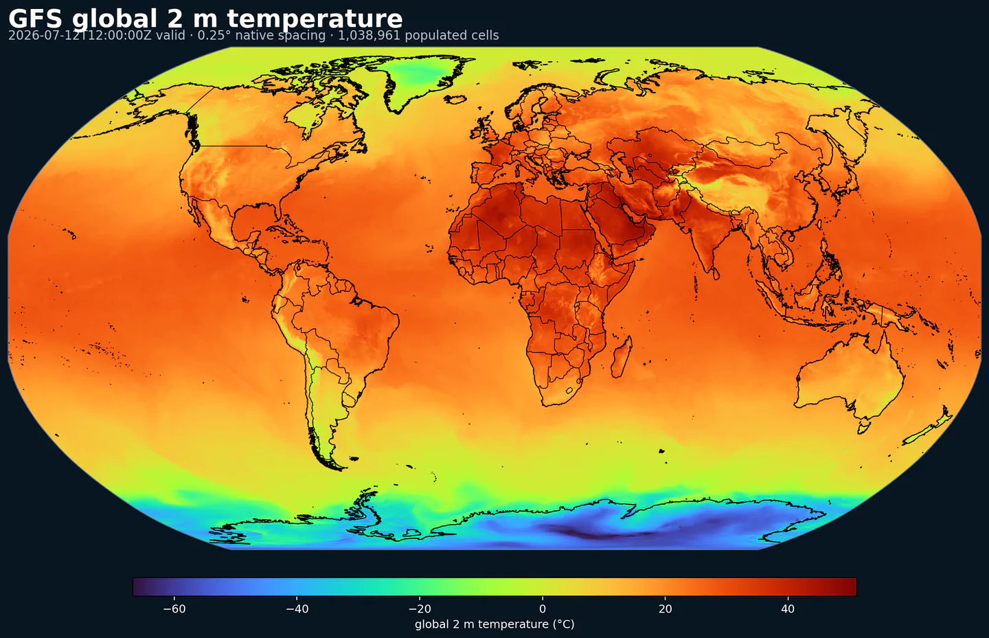
Air temperature is the thermal state of the atmosphere at the specified level. It influences density, stability, and energy exchange.
| Level | Info | Horizon | Introduced | Selector |
|---|---|---|---|---|
0.01 mb |
0h-384h | 2021-03-22 |
{"name":"TMP","level":"0.01 mb","info":""}
|
|
0.02 mb |
0h-384h | 2021-03-22 |
{"name":"TMP","level":"0.02 mb","info":""}
|
|
0.04 mb |
0h-384h | 2021-03-22 |
{"name":"TMP","level":"0.04 mb","info":""}
|
|
0.07 mb |
0h-384h | 2021-03-22 |
{"name":"TMP","level":"0.07 mb","info":""}
|
|
0.1 mb |
0h-384h | 2021-03-22 |
{"name":"TMP","level":"0.1 mb","info":""}
|
|
0.2 mb |
0h-384h | 2021-03-22 |
{"name":"TMP","level":"0.2 mb","info":""}
|
|
0.4 mb |
0h-384h | 2021-03-22 |
{"name":"TMP","level":"0.4 mb","info":""}
|
|
0.7 mb |
0h-384h | 2021-03-22 |
{"name":"TMP","level":"0.7 mb","info":""}
|
|
0.995 sigma level |
0h-384h | 2021-03-22 |
{"name":"TMP","level":"0.995 sigma level","info":""}
|
|
1 mb |
0h-384h | 2021-03-22 |
{"name":"TMP","level":"1 mb","info":""}
|
|
10 mb |
0h-384h | 2021-03-22 |
{"name":"TMP","level":"10 mb","info":""}
|
|
100 m above ground |
0h-384h | 2021-03-22 |
{"name":"TMP","level":"100 m above ground","info":""}
|
|
100 mb |
0h-384h | 2021-03-22 |
{"name":"TMP","level":"100 mb","info":""}
|
|
1000 mb |
0h-384h | 2021-03-22 |
{"name":"TMP","level":"1000 mb","info":""}
|
|
15 mb |
0h-384h | 2021-03-22 |
{"name":"TMP","level":"15 mb","info":""}
|
|
150 mb |
0h-384h | 2021-03-22 |
{"name":"TMP","level":"150 mb","info":""}
|
|
1829 m above mean sea level |
0h-384h | 2021-03-22 |
{"name":"TMP","level":"1829 m above mean sea level","info":""}
|
|
2 m above ground |
0h-384h | 2021-03-22 |
{"name":"TMP","level":"2 m above ground","info":""}
|
|
2 mb |
0h-384h | 2021-03-22 |
{"name":"TMP","level":"2 mb","info":""}
|
|
20 mb |
0h-384h | 2021-03-22 |
{"name":"TMP","level":"20 mb","info":""}
|
|
200 mb |
0h-384h | 2021-03-22 |
{"name":"TMP","level":"200 mb","info":""}
|
|
250 mb |
0h-384h | 2021-03-22 |
{"name":"TMP","level":"250 mb","info":""}
|
|
2743 m above mean sea level |
0h-384h | 2021-03-22 |
{"name":"TMP","level":"2743 m above mean sea level","info":""}
|
|
3 mb |
0h-384h | 2021-03-22 |
{"name":"TMP","level":"3 mb","info":""}
|
|
30 mb |
0h-384h | 2021-03-22 |
{"name":"TMP","level":"30 mb","info":""}
|
|
30-0 mb above ground |
0h-384h | 2021-03-22 |
{"name":"TMP","level":"30-0 mb above ground","info":""}
|
|
300 mb |
0h-384h | 2021-03-22 |
{"name":"TMP","level":"300 mb","info":""}
|
|
350 mb |
0h-384h | 2021-03-22 |
{"name":"TMP","level":"350 mb","info":""}
|
|
3658 m above mean sea level |
0h-384h | 2021-03-22 |
{"name":"TMP","level":"3658 m above mean sea level","info":""}
|
|
40 mb |
0h-384h | 2021-03-22 |
{"name":"TMP","level":"40 mb","info":""}
|
|
400 mb |
0h-384h | 2021-03-22 |
{"name":"TMP","level":"400 mb","info":""}
|
|
450 mb |
0h-384h | 2021-03-22 |
{"name":"TMP","level":"450 mb","info":""}
|
|
5 mb |
0h-384h | 2021-03-22 |
{"name":"TMP","level":"5 mb","info":""}
|
|
50 mb |
0h-384h | 2021-03-22 |
{"name":"TMP","level":"50 mb","info":""}
|
|
500 mb |
0h-384h | 2021-03-22 |
{"name":"TMP","level":"500 mb","info":""}
|
|
550 mb |
0h-384h | 2021-03-22 |
{"name":"TMP","level":"550 mb","info":""}
|
|
600 mb |
0h-384h | 2021-03-22 |
{"name":"TMP","level":"600 mb","info":""}
|
|
650 mb |
0h-384h | 2021-03-22 |
{"name":"TMP","level":"650 mb","info":""}
|
|
7 mb |
0h-384h | 2021-03-22 |
{"name":"TMP","level":"7 mb","info":""}
|
|
70 mb |
0h-384h | 2021-03-22 |
{"name":"TMP","level":"70 mb","info":""}
|
|
700 mb |
0h-384h | 2021-03-22 |
{"name":"TMP","level":"700 mb","info":""}
|
|
750 mb |
0h-384h | 2021-03-22 |
{"name":"TMP","level":"750 mb","info":""}
|
|
80 m above ground |
0h-384h | 2021-03-22 |
{"name":"TMP","level":"80 m above ground","info":""}
|
|
800 mb |
0h-384h | 2021-03-22 |
{"name":"TMP","level":"800 mb","info":""}
|
|
850 mb |
0h-384h | 2021-03-22 |
{"name":"TMP","level":"850 mb","info":""}
|
|
900 mb |
0h-384h | 2021-03-22 |
{"name":"TMP","level":"900 mb","info":""}
|
|
925 mb |
0h-384h | 2021-03-22 |
{"name":"TMP","level":"925 mb","info":""}
|
|
950 mb |
0h-384h | 2021-03-22 |
{"name":"TMP","level":"950 mb","info":""}
|
|
975 mb |
0h-384h | 2021-03-22 |
{"name":"TMP","level":"975 mb","info":""}
|
|
PV=-2e-06 (Km^2/kg/s) surface |
0h-384h | 2021-03-22 |
{"name":"TMP","level":"PV=-2e-06 (Km^2/kg/s) surface","info":""}
|
|
PV=2e-06 (Km^2/kg/s) surface |
0h-384h | 2021-03-22 |
{"name":"TMP","level":"PV=2e-06 (Km^2/kg/s) surface","info":""}
|
|
high cloud top level |
1h-384h | 2021-03-22 |
{"name":"TMP","level":"high cloud top level","info":""}
|
|
low cloud top level |
1h-384h | 2021-03-22 |
{"name":"TMP","level":"low cloud top level","info":""}
|
|
max wind |
0h-384h | 2021-03-22 |
{"name":"TMP","level":"max wind","info":""}
|
|
middle cloud top level |
1h-384h | 2021-03-22 |
{"name":"TMP","level":"middle cloud top level","info":""}
|
|
surface |
0h-384h | 2021-03-22 |
{"name":"TMP","level":"surface","info":""}
|
|
tropopause |
0h-384h | 2021-03-22 |
{"name":"TMP","level":"tropopause","info":""}
|
Total column ozone is the integrated ozone amount through the atmosphere. It affects UV radiation reaching the surface and atmospheric chemistry.
| Level | Info | Horizon | Introduced | Selector |
|---|---|---|---|---|
entire atmosphere (considered as a single layer) |
0h-384h | 2021-03-22 |
{"name":"TOZNE","level":"entire atmosphere (considered as a single layer)","info":""}
|
Soil temperature describes the thermal state of the soil layer. It affects ground heat flux and freeze/thaw processes.
| Level | Info | Horizon | Introduced | Selector |
|---|---|---|---|---|
0-0.1 m below ground |
0h-384h | 2021-03-22 |
{"name":"TSOIL","level":"0-0.1 m below ground","info":""}
|
|
0.1-0.4 m below ground |
0h-384h | 2021-03-22 |
{"name":"TSOIL","level":"0.1-0.4 m below ground","info":""}
|
|
0.4-1 m below ground |
0h-384h | 2021-03-22 |
{"name":"TSOIL","level":"0.4-1 m below ground","info":""}
|
|
1-2 m below ground |
0h-384h | 2021-03-22 |
{"name":"TSOIL","level":"1-2 m below ground","info":""}
|
Zonal gravity wave stress is the east-west component of momentum flux from unresolved gravity waves. It affects large-scale circulation and jet dynamics.
| Level | Info | Horizon | Introduced | Selector |
|---|---|---|---|---|
surface |
1h-384h | 2021-03-22 |
{"name":"U-GWD","level":"surface","info":""}
|
Momentum flux, u‑component is the east‑west surface stress exerted by the atmosphere. It drives boundary-layer dynamics.
| Level | Info | Horizon | Introduced | Selector |
|---|---|---|---|---|
surface |
1h-384h | 2021-03-22 |
{"name":"UFLX","level":"surface","info":""}
|
U‑component of wind is the east‑west component of the horizontal wind. Combine with v for speed and direction.
| Level | Info | Horizon | Introduced | Selector |
|---|---|---|---|---|
0.01 mb |
0h-384h | 2021-03-22 |
{"name":"UGRD","level":"0.01 mb","info":""}
|
|
0.02 mb |
0h-384h | 2021-03-22 |
{"name":"UGRD","level":"0.02 mb","info":""}
|
|
0.04 mb |
0h-384h | 2021-03-22 |
{"name":"UGRD","level":"0.04 mb","info":""}
|
|
0.07 mb |
0h-384h | 2021-03-22 |
{"name":"UGRD","level":"0.07 mb","info":""}
|
|
0.1 mb |
0h-384h | 2021-03-22 |
{"name":"UGRD","level":"0.1 mb","info":""}
|
|
0.2 mb |
0h-384h | 2021-03-22 |
{"name":"UGRD","level":"0.2 mb","info":""}
|
|
0.4 mb |
0h-384h | 2021-03-22 |
{"name":"UGRD","level":"0.4 mb","info":""}
|
|
0.7 mb |
0h-384h | 2021-03-22 |
{"name":"UGRD","level":"0.7 mb","info":""}
|
|
0.995 sigma level |
0h-384h | 2021-03-22 |
{"name":"UGRD","level":"0.995 sigma level","info":""}
|
|
1 mb |
0h-384h | 2021-03-22 |
{"name":"UGRD","level":"1 mb","info":""}
|
|
10 m above ground |
0h-384h | 2021-03-22 |
{"name":"UGRD","level":"10 m above ground","info":""}
|
|
10 mb |
0h-384h | 2021-03-22 |
{"name":"UGRD","level":"10 mb","info":""}
|
|
100 m above ground |
0h-384h | 2021-03-22 |
{"name":"UGRD","level":"100 m above ground","info":""}
|
|
100 mb |
0h-384h | 2021-03-22 |
{"name":"UGRD","level":"100 mb","info":""}
|
|
1000 mb |
0h-384h | 2021-03-22 |
{"name":"UGRD","level":"1000 mb","info":""}
|
|
15 mb |
0h-384h | 2021-03-22 |
{"name":"UGRD","level":"15 mb","info":""}
|
|
150 mb |
0h-384h | 2021-03-22 |
{"name":"UGRD","level":"150 mb","info":""}
|
|
1829 m above mean sea level |
0h-384h | 2021-03-22 |
{"name":"UGRD","level":"1829 m above mean sea level","info":""}
|
|
2 mb |
0h-384h | 2021-03-22 |
{"name":"UGRD","level":"2 mb","info":""}
|
|
20 m above ground |
0h-384h | 2021-03-22 |
{"name":"UGRD","level":"20 m above ground","info":""}
|
|
20 mb |
0h-384h | 2021-03-22 |
{"name":"UGRD","level":"20 mb","info":""}
|
|
200 mb |
0h-384h | 2021-03-22 |
{"name":"UGRD","level":"200 mb","info":""}
|
|
250 mb |
0h-384h | 2021-03-22 |
{"name":"UGRD","level":"250 mb","info":""}
|
|
2743 m above mean sea level |
0h-384h | 2021-03-22 |
{"name":"UGRD","level":"2743 m above mean sea level","info":""}
|
|
3 mb |
0h-384h | 2021-03-22 |
{"name":"UGRD","level":"3 mb","info":""}
|
|
30 m above ground |
0h-384h | 2021-03-22 |
{"name":"UGRD","level":"30 m above ground","info":""}
|
|
30 mb |
0h-384h | 2021-03-22 |
{"name":"UGRD","level":"30 mb","info":""}
|
|
30-0 mb above ground |
0h-384h | 2021-03-22 |
{"name":"UGRD","level":"30-0 mb above ground","info":""}
|
|
300 mb |
0h-384h | 2021-03-22 |
{"name":"UGRD","level":"300 mb","info":""}
|
|
350 mb |
0h-384h | 2021-03-22 |
{"name":"UGRD","level":"350 mb","info":""}
|
|
3658 m above mean sea level |
0h-384h | 2021-03-22 |
{"name":"UGRD","level":"3658 m above mean sea level","info":""}
|
|
40 m above ground |
0h-384h | 2021-03-22 |
{"name":"UGRD","level":"40 m above ground","info":""}
|
|
40 mb |
0h-384h | 2021-03-22 |
{"name":"UGRD","level":"40 mb","info":""}
|
|
400 mb |
0h-384h | 2021-03-22 |
{"name":"UGRD","level":"400 mb","info":""}
|
|
450 mb |
0h-384h | 2021-03-22 |
{"name":"UGRD","level":"450 mb","info":""}
|
|
5 mb |
0h-384h | 2021-03-22 |
{"name":"UGRD","level":"5 mb","info":""}
|
|
50 m above ground |
0h-384h | 2021-03-22 |
{"name":"UGRD","level":"50 m above ground","info":""}
|
|
50 mb |
0h-384h | 2021-03-22 |
{"name":"UGRD","level":"50 mb","info":""}
|
|
500 mb |
0h-384h | 2021-03-22 |
{"name":"UGRD","level":"500 mb","info":""}
|
|
550 mb |
0h-384h | 2021-03-22 |
{"name":"UGRD","level":"550 mb","info":""}
|
|
600 mb |
0h-384h | 2021-03-22 |
{"name":"UGRD","level":"600 mb","info":""}
|
|
650 mb |
0h-384h | 2021-03-22 |
{"name":"UGRD","level":"650 mb","info":""}
|
|
7 mb |
0h-384h | 2021-03-22 |
{"name":"UGRD","level":"7 mb","info":""}
|
|
70 mb |
0h-384h | 2021-03-22 |
{"name":"UGRD","level":"70 mb","info":""}
|
|
700 mb |
0h-384h | 2021-03-22 |
{"name":"UGRD","level":"700 mb","info":""}
|
|
750 mb |
0h-384h | 2021-03-22 |
{"name":"UGRD","level":"750 mb","info":""}
|
|
80 m above ground |
0h-384h | 2021-03-22 |
{"name":"UGRD","level":"80 m above ground","info":""}
|
|
800 mb |
0h-384h | 2021-03-22 |
{"name":"UGRD","level":"800 mb","info":""}
|
|
850 mb |
0h-384h | 2021-03-22 |
{"name":"UGRD","level":"850 mb","info":""}
|
|
900 mb |
0h-384h | 2021-03-22 |
{"name":"UGRD","level":"900 mb","info":""}
|
|
925 mb |
0h-384h | 2021-03-22 |
{"name":"UGRD","level":"925 mb","info":""}
|
|
950 mb |
0h-384h | 2021-03-22 |
{"name":"UGRD","level":"950 mb","info":""}
|
|
975 mb |
0h-384h | 2021-03-22 |
{"name":"UGRD","level":"975 mb","info":""}
|
|
PV=-2e-06 (Km^2/kg/s) surface |
0h-384h | 2021-03-22 |
{"name":"UGRD","level":"PV=-2e-06 (Km^2/kg/s) surface","info":""}
|
|
PV=2e-06 (Km^2/kg/s) surface |
0h-384h | 2021-03-22 |
{"name":"UGRD","level":"PV=2e-06 (Km^2/kg/s) surface","info":""}
|
|
max wind |
0h-384h | 2021-03-22 |
{"name":"UGRD","level":"max wind","info":""}
|
|
planetary boundary layer |
0h-384h | 2021-03-22 |
{"name":"UGRD","level":"planetary boundary layer","info":""}
|
|
tropopause |
0h-384h | 2021-03-22 |
{"name":"UGRD","level":"tropopause","info":""}
|
Upward longwave (thermal) flux represents outgoing energy at the surface. It is a key driver of surface heating and cooling.
| Level | Info | Horizon | Introduced | Selector |
|---|---|---|---|---|
surface |
1h-384h | 2021-03-22 |
{"name":"ULWRF","level":"surface","info":""}
|
|
top of atmosphere |
1h-384h | 2021-03-22 |
{"name":"ULWRF","level":"top of atmosphere","info":""}
|
U‑component of storm motion is the east‑west component of the storm translation vector.
| Level | Info | Horizon | Introduced | Selector |
|---|---|---|---|---|
6000-0 m above ground |
0h-384h | 2021-03-22 |
{"name":"USTM","level":"6000-0 m above ground","info":""}
|
Upward radiative flux represents outgoing energy at the surface. It is a key driver of surface heating and cooling.
| Level | Info | Horizon | Introduced | Selector |
|---|---|---|---|---|
surface |
1h-384h | 2021-03-22 |
{"name":"USWRF","level":"surface","info":""}
|
|
top of atmosphere |
1h-384h | 2021-03-22 |
{"name":"USWRF","level":"top of atmosphere","info":""}
|
Meridional gravity wave stress is the north-south component of momentum flux from unresolved gravity waves. It affects large-scale circulation and jet dynamics.
| Level | Info | Horizon | Introduced | Selector |
|---|---|---|---|---|
surface |
1h-384h | 2021-03-22 |
{"name":"V-GWD","level":"surface","info":""}
|
Vegetation fraction is the portion of the grid cell covered by vegetation. It affects albedo, roughness, and evapotranspiration.
| Level | Info | Horizon | Introduced | Selector |
|---|---|---|---|---|
surface |
0h-384h | 2021-03-22 |
{"name":"VEG","level":"surface","info":""}
|
Momentum flux, v‑component is the north‑south surface stress exerted by the atmosphere. It drives boundary-layer dynamics.
| Level | Info | Horizon | Introduced | Selector |
|---|---|---|---|---|
surface |
1h-384h | 2021-03-22 |
{"name":"VFLX","level":"surface","info":""}
|
V‑component of wind is the north‑south component of the horizontal wind. Combine with u for speed and direction.
| Level | Info | Horizon | Introduced | Selector |
|---|---|---|---|---|
0.01 mb |
0h-384h | 2021-03-22 |
{"name":"VGRD","level":"0.01 mb","info":""}
|
|
0.02 mb |
0h-384h | 2021-03-22 |
{"name":"VGRD","level":"0.02 mb","info":""}
|
|
0.04 mb |
0h-384h | 2021-03-22 |
{"name":"VGRD","level":"0.04 mb","info":""}
|
|
0.07 mb |
0h-384h | 2021-03-22 |
{"name":"VGRD","level":"0.07 mb","info":""}
|
|
0.1 mb |
0h-384h | 2021-03-22 |
{"name":"VGRD","level":"0.1 mb","info":""}
|
|
0.2 mb |
0h-384h | 2021-03-22 |
{"name":"VGRD","level":"0.2 mb","info":""}
|
|
0.4 mb |
0h-384h | 2021-03-22 |
{"name":"VGRD","level":"0.4 mb","info":""}
|
|
0.7 mb |
0h-384h | 2021-03-22 |
{"name":"VGRD","level":"0.7 mb","info":""}
|
|
0.995 sigma level |
0h-384h | 2021-03-22 |
{"name":"VGRD","level":"0.995 sigma level","info":""}
|
|
1 mb |
0h-384h | 2021-03-22 |
{"name":"VGRD","level":"1 mb","info":""}
|
|
10 m above ground |
0h-384h | 2021-03-22 |
{"name":"VGRD","level":"10 m above ground","info":""}
|
|
10 mb |
0h-384h | 2021-03-22 |
{"name":"VGRD","level":"10 mb","info":""}
|
|
100 m above ground |
0h-384h | 2021-03-22 |
{"name":"VGRD","level":"100 m above ground","info":""}
|
|
100 mb |
0h-384h | 2021-03-22 |
{"name":"VGRD","level":"100 mb","info":""}
|
|
1000 mb |
0h-384h | 2021-03-22 |
{"name":"VGRD","level":"1000 mb","info":""}
|
|
15 mb |
0h-384h | 2021-03-22 |
{"name":"VGRD","level":"15 mb","info":""}
|
|
150 mb |
0h-384h | 2021-03-22 |
{"name":"VGRD","level":"150 mb","info":""}
|
|
1829 m above mean sea level |
0h-384h | 2021-03-22 |
{"name":"VGRD","level":"1829 m above mean sea level","info":""}
|
|
2 mb |
0h-384h | 2021-03-22 |
{"name":"VGRD","level":"2 mb","info":""}
|
|
20 m above ground |
0h-384h | 2021-03-22 |
{"name":"VGRD","level":"20 m above ground","info":""}
|
|
20 mb |
0h-384h | 2021-03-22 |
{"name":"VGRD","level":"20 mb","info":""}
|
|
200 mb |
0h-384h | 2021-03-22 |
{"name":"VGRD","level":"200 mb","info":""}
|
|
250 mb |
0h-384h | 2021-03-22 |
{"name":"VGRD","level":"250 mb","info":""}
|
|
2743 m above mean sea level |
0h-384h | 2021-03-22 |
{"name":"VGRD","level":"2743 m above mean sea level","info":""}
|
|
3 mb |
0h-384h | 2021-03-22 |
{"name":"VGRD","level":"3 mb","info":""}
|
|
30 m above ground |
0h-384h | 2021-03-22 |
{"name":"VGRD","level":"30 m above ground","info":""}
|
|
30 mb |
0h-384h | 2021-03-22 |
{"name":"VGRD","level":"30 mb","info":""}
|
|
30-0 mb above ground |
0h-384h | 2021-03-22 |
{"name":"VGRD","level":"30-0 mb above ground","info":""}
|
|
300 mb |
0h-384h | 2021-03-22 |
{"name":"VGRD","level":"300 mb","info":""}
|
|
350 mb |
0h-384h | 2021-03-22 |
{"name":"VGRD","level":"350 mb","info":""}
|
|
3658 m above mean sea level |
0h-384h | 2021-03-22 |
{"name":"VGRD","level":"3658 m above mean sea level","info":""}
|
|
40 m above ground |
0h-384h | 2021-03-22 |
{"name":"VGRD","level":"40 m above ground","info":""}
|
|
40 mb |
0h-384h | 2021-03-22 |
{"name":"VGRD","level":"40 mb","info":""}
|
|
400 mb |
0h-384h | 2021-03-22 |
{"name":"VGRD","level":"400 mb","info":""}
|
|
450 mb |
0h-384h | 2021-03-22 |
{"name":"VGRD","level":"450 mb","info":""}
|
|
5 mb |
0h-384h | 2021-03-22 |
{"name":"VGRD","level":"5 mb","info":""}
|
|
50 m above ground |
0h-384h | 2021-03-22 |
{"name":"VGRD","level":"50 m above ground","info":""}
|
|
50 mb |
0h-384h | 2021-03-22 |
{"name":"VGRD","level":"50 mb","info":""}
|
|
500 mb |
0h-384h | 2021-03-22 |
{"name":"VGRD","level":"500 mb","info":""}
|
|
550 mb |
0h-384h | 2021-03-22 |
{"name":"VGRD","level":"550 mb","info":""}
|
|
600 mb |
0h-384h | 2021-03-22 |
{"name":"VGRD","level":"600 mb","info":""}
|
|
650 mb |
0h-384h | 2021-03-22 |
{"name":"VGRD","level":"650 mb","info":""}
|
|
7 mb |
0h-384h | 2021-03-22 |
{"name":"VGRD","level":"7 mb","info":""}
|
|
70 mb |
0h-384h | 2021-03-22 |
{"name":"VGRD","level":"70 mb","info":""}
|
|
700 mb |
0h-384h | 2021-03-22 |
{"name":"VGRD","level":"700 mb","info":""}
|
|
750 mb |
0h-384h | 2021-03-22 |
{"name":"VGRD","level":"750 mb","info":""}
|
|
80 m above ground |
0h-384h | 2021-03-22 |
{"name":"VGRD","level":"80 m above ground","info":""}
|
|
800 mb |
0h-384h | 2021-03-22 |
{"name":"VGRD","level":"800 mb","info":""}
|
|
850 mb |
0h-384h | 2021-03-22 |
{"name":"VGRD","level":"850 mb","info":""}
|
|
900 mb |
0h-384h | 2021-03-22 |
{"name":"VGRD","level":"900 mb","info":""}
|
|
925 mb |
0h-384h | 2021-03-22 |
{"name":"VGRD","level":"925 mb","info":""}
|
|
950 mb |
0h-384h | 2021-03-22 |
{"name":"VGRD","level":"950 mb","info":""}
|
|
975 mb |
0h-384h | 2021-03-22 |
{"name":"VGRD","level":"975 mb","info":""}
|
|
PV=-2e-06 (Km^2/kg/s) surface |
0h-384h | 2021-03-22 |
{"name":"VGRD","level":"PV=-2e-06 (Km^2/kg/s) surface","info":""}
|
|
PV=2e-06 (Km^2/kg/s) surface |
0h-384h | 2021-03-22 |
{"name":"VGRD","level":"PV=2e-06 (Km^2/kg/s) surface","info":""}
|
|
max wind |
0h-384h | 2021-03-22 |
{"name":"VGRD","level":"max wind","info":""}
|
|
planetary boundary layer |
0h-384h | 2021-03-22 |
{"name":"VGRD","level":"planetary boundary layer","info":""}
|
|
tropopause |
0h-384h | 2021-03-22 |
{"name":"VGRD","level":"tropopause","info":""}
|
Horizontal visibility at the surface. Lower values indicate reduced visibility due to fog, precipitation, or aerosols.
| Level | Info | Horizon | Introduced | Selector |
|---|---|---|---|---|
surface |
0h-384h | 2021-03-22 |
{"name":"VIS","level":"surface","info":""}
|
Ventilation rate combines mixing depth and transport wind to estimate the atmosphere's ability to disperse smoke and pollutants.
| Level | Info | Horizon | Introduced | Selector |
|---|---|---|---|---|
planetary boundary layer |
0h-384h | 2021-03-22 |
{"name":"VRATE","level":"planetary boundary layer","info":""}
|
V-component storm motion represents the north-south component of storm motion. Positive values indicate motion toward the north.
| Level | Info | Horizon | Introduced | Selector |
|---|---|---|---|---|
6000-0 m above ground |
0h-384h | 2021-03-22 |
{"name":"VSTM","level":"6000-0 m above ground","info":""}
|
Vertical velocity in pressure coordinates (omega). Negative values indicate upward motion (rising air); positive values indicate subsidence.
| Level | Info | Horizon | Introduced | Selector |
|---|---|---|---|---|
0.01 mb |
0h-384h | 2021-03-22 |
{"name":"VVEL","level":"0.01 mb","info":""}
|
|
0.02 mb |
0h-384h | 2021-03-22 |
{"name":"VVEL","level":"0.02 mb","info":""}
|
|
0.04 mb |
0h-384h | 2021-03-22 |
{"name":"VVEL","level":"0.04 mb","info":""}
|
|
0.07 mb |
0h-384h | 2021-03-22 |
{"name":"VVEL","level":"0.07 mb","info":""}
|
|
0.1 mb |
0h-384h | 2021-03-22 |
{"name":"VVEL","level":"0.1 mb","info":""}
|
|
0.2 mb |
0h-384h | 2021-03-22 |
{"name":"VVEL","level":"0.2 mb","info":""}
|
|
0.4 mb |
0h-384h | 2021-03-22 |
{"name":"VVEL","level":"0.4 mb","info":""}
|
|
0.7 mb |
0h-384h | 2021-03-22 |
{"name":"VVEL","level":"0.7 mb","info":""}
|
|
0.995 sigma level |
0h-384h | 2021-03-22 |
{"name":"VVEL","level":"0.995 sigma level","info":""}
|
|
1 mb |
0h-384h | 2021-03-22 |
{"name":"VVEL","level":"1 mb","info":""}
|
|
10 mb |
0h-384h | 2021-03-22 |
{"name":"VVEL","level":"10 mb","info":""}
|
|
100 mb |
0h-384h | 2021-03-22 |
{"name":"VVEL","level":"100 mb","info":""}
|
|
1000 mb |
0h-384h | 2021-03-22 |
{"name":"VVEL","level":"1000 mb","info":""}
|
|
15 mb |
0h-384h | 2021-03-22 |
{"name":"VVEL","level":"15 mb","info":""}
|
|
150 mb |
0h-384h | 2021-03-22 |
{"name":"VVEL","level":"150 mb","info":""}
|
|
2 mb |
0h-384h | 2021-03-22 |
{"name":"VVEL","level":"2 mb","info":""}
|
|
20 mb |
0h-384h | 2021-03-22 |
{"name":"VVEL","level":"20 mb","info":""}
|
|
200 mb |
0h-384h | 2021-03-22 |
{"name":"VVEL","level":"200 mb","info":""}
|
|
250 mb |
0h-384h | 2021-03-22 |
{"name":"VVEL","level":"250 mb","info":""}
|
|
3 mb |
0h-384h | 2021-03-22 |
{"name":"VVEL","level":"3 mb","info":""}
|
|
30 mb |
0h-384h | 2021-03-22 |
{"name":"VVEL","level":"30 mb","info":""}
|
|
300 mb |
0h-384h | 2021-03-22 |
{"name":"VVEL","level":"300 mb","info":""}
|
|
350 mb |
0h-384h | 2021-03-22 |
{"name":"VVEL","level":"350 mb","info":""}
|
|
40 mb |
0h-384h | 2021-03-22 |
{"name":"VVEL","level":"40 mb","info":""}
|
|
400 mb |
0h-384h | 2021-03-22 |
{"name":"VVEL","level":"400 mb","info":""}
|
|
450 mb |
0h-384h | 2021-03-22 |
{"name":"VVEL","level":"450 mb","info":""}
|
|
5 mb |
0h-384h | 2021-03-22 |
{"name":"VVEL","level":"5 mb","info":""}
|
|
50 mb |
0h-384h | 2021-03-22 |
{"name":"VVEL","level":"50 mb","info":""}
|
|
500 mb |
0h-384h | 2021-03-22 |
{"name":"VVEL","level":"500 mb","info":""}
|
|
550 mb |
0h-384h | 2021-03-22 |
{"name":"VVEL","level":"550 mb","info":""}
|
|
600 mb |
0h-384h | 2021-03-22 |
{"name":"VVEL","level":"600 mb","info":""}
|
|
650 mb |
0h-384h | 2021-03-22 |
{"name":"VVEL","level":"650 mb","info":""}
|
|
7 mb |
0h-384h | 2021-03-22 |
{"name":"VVEL","level":"7 mb","info":""}
|
|
70 mb |
0h-384h | 2021-03-22 |
{"name":"VVEL","level":"70 mb","info":""}
|
|
700 mb |
0h-384h | 2021-03-22 |
{"name":"VVEL","level":"700 mb","info":""}
|
|
750 mb |
0h-384h | 2021-03-22 |
{"name":"VVEL","level":"750 mb","info":""}
|
|
800 mb |
0h-384h | 2021-03-22 |
{"name":"VVEL","level":"800 mb","info":""}
|
|
850 mb |
0h-384h | 2021-03-22 |
{"name":"VVEL","level":"850 mb","info":""}
|
|
900 mb |
0h-384h | 2021-03-22 |
{"name":"VVEL","level":"900 mb","info":""}
|
|
925 mb |
0h-384h | 2021-03-22 |
{"name":"VVEL","level":"925 mb","info":""}
|
|
950 mb |
0h-384h | 2021-03-22 |
{"name":"VVEL","level":"950 mb","info":""}
|
|
975 mb |
0h-384h | 2021-03-22 |
{"name":"VVEL","level":"975 mb","info":""}
|
Vertical wind shear measures how wind changes with height. It influences storm organization and aviation turbulence.
| Level | Info | Horizon | Introduced | Selector |
|---|---|---|---|---|
PV=-2e-06 (Km^2/kg/s) surface |
0h-384h | 2021-03-22 |
{"name":"VWSH","level":"PV=-2e-06 (Km^2/kg/s) surface","info":""}
|
|
PV=2e-06 (Km^2/kg/s) surface |
0h-384h | 2021-03-22 |
{"name":"VWSH","level":"PV=2e-06 (Km^2/kg/s) surface","info":""}
|
|
tropopause |
0h-384h | 2021-03-22 |
{"name":"VWSH","level":"tropopause","info":""}
|
Water runoff is the amount of water leaving the land surface as runoff during the period. It is useful for hydrology, flooding, and land-surface diagnostics.
| Level | Info | Horizon | Introduced | Selector |
|---|---|---|---|---|
surface |
1h-384h | 2021-03-22 |
{"name":"WATR","level":"surface","info":""}
|
Snow water equivalent (SWE) is the total liquid water stored in the snowpack. It integrates depth and density of existing snow.
| Level | Info | Horizon | Introduced | Selector |
|---|---|---|---|---|
surface |
0h-384h | 2021-03-22 |
{"name":"WEASD","level":"surface","info":""}
|
Wilting point is the soil moisture threshold below which plants can no longer extract water. It is used in drought and vegetation stress diagnostics.
| Level | Info | Horizon | Introduced | Selector |
|---|---|---|---|---|
surface |
0h-384h | 2021-03-22 |
{"name":"WILT","level":"surface","info":""}
|
No parameters match your search.