Ceiling height is the altitude of the lowest cloud base that covers a significant portion of the sky. It is a key aviation and surface-visibility metric.
- Units: m.
rtma
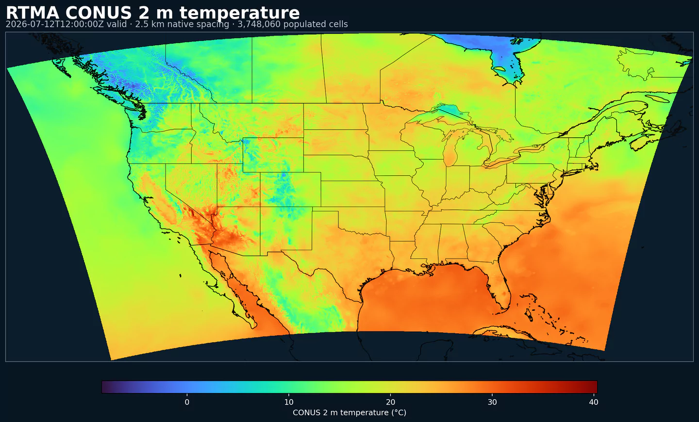
RTMA (Real-Time Mesoscale Analysis) is NOAA/NCEP's near-real-time, hourly surface analysis designed to provide the best estimate of current weather conditions within about 30-45 minutes of valid time. It uses a two-dimensional variational (2D-Var) assimilation system to combine a short-range model background with surface, mesonet, buoy, ship, and radar-derived observations.
The analysis is generated on the National Digital Forecast Database (NDFD) grids, including the 2.5 km CONUS Lambert Conformal grid, as well as Alaska (~3 km), Hawaii, Puerto Rico, and Guam. Standard RTMA parameters include 2 m temperature, dewpoint, 10 m wind speed, direction, gust, surface pressure, visibility, cloud ceiling, and precipitation fields. RTMA provides high-resolution situational awareness in regions with sparse observations, including offshore waters and complex terrain.
Because RTMA prioritizes timeliness, it does not incorporate late-arriving observations. Instead, its role is to provide a provisional near-current analysis, supporting operational dashboards, bias correction, and rapid verification of short-term forecasts. For finalized, higher-quality analyses, see URMA, which reruns RTMA about six hours later with expanded datasets.
Click a parameter to reveal variants in a compact table with ready-to-copy JSON selectors.
Ceiling height is the altitude of the lowest cloud base that covers a significant portion of the sky. It is a key aviation and surface-visibility metric.
| Level | Info | Horizon | Introduced | Selector |
|---|---|---|---|---|
cloud ceiling |
0h | 2018-01-01 |
{"name":"CEIL","level":"cloud ceiling","info":""}
|
Dew point temperature is the temperature at which the air becomes saturated. It is a direct measure of moisture content.
| Level | Info | Horizon | Introduced | Selector |
|---|---|---|---|---|
2 m above ground |
0h | 2018-01-01 |
{"name":"DPT","level":"2 m above ground","info":""}
|
Wind gust is the peak short-duration wind speed. It captures brief, hazardous bursts that can exceed sustained winds.
| Level | Info | Horizon | Introduced | Selector |
|---|---|---|---|---|
10 m above ground |
0h | 2018-01-01 |
{"name":"GUST","level":"10 m above ground","info":""}
|
Geopotential height is the altitude of a pressure surface in the atmosphere. It is the primary field for identifying ridges, troughs, and large‑scale flow patterns.
| Level | Info | Horizon | Introduced | Selector |
|---|---|---|---|---|
surface |
0h | 2018-01-01 |
{"name":"HGT","level":"surface","info":""}
|
Pressure is the atmospheric pressure at the specified level. It is a fundamental mass-field variable for dynamics and thermodynamics.
| Level | Info | Horizon | Introduced | Selector |
|---|---|---|---|---|
surface |
0h | 2018-01-01 |
{"name":"PRES","level":"surface","info":""}
|
Specific humidity is the mass of water vapor per mass of air at the specified level. It is central to moisture transport.
| Level | Info | Horizon | Introduced | Selector |
|---|---|---|---|---|
2 m above ground |
0h | 2018-01-01 |
{"name":"SPFH","level":"2 m above ground","info":""}
|
Total cloud cover is the fraction of the grid cell covered by clouds at any level. It influences radiation, temperature, and visibility.
| Level | Info | Horizon | Introduced | Selector |
|---|---|---|---|---|
entire atmosphere (considered as a single layer) |
0h | 2018-01-01 |
{"name":"TCDC","level":"entire atmosphere (considered as a single layer)","info":""}
|
Air temperature is the thermal state of the atmosphere at the specified level. It influences density, stability, and energy exchange.
| Level | Info | Horizon | Introduced | Selector |
|---|---|---|---|---|
2 m above ground |
0h | 2018-01-01 |
{"name":"TMP","level":"2 m above ground","info":""}
|
U‑component of wind is the east‑west component of the horizontal wind. Combine with v for speed and direction.
| Level | Info | Horizon | Introduced | Selector |
|---|---|---|---|---|
10 m above ground |
0h | 2018-01-01 |
{"name":"UGRD","level":"10 m above ground","info":""}
|
V‑component of wind is the north‑south component of the horizontal wind. Combine with u for speed and direction.
| Level | Info | Horizon | Introduced | Selector |
|---|---|---|---|---|
10 m above ground |
0h | 2018-01-01 |
{"name":"VGRD","level":"10 m above ground","info":""}
|
Horizontal visibility at the surface. Lower values indicate reduced visibility due to fog, precipitation, or aerosols.
| Level | Info | Horizon | Introduced | Selector |
|---|---|---|---|---|
surface |
0h | 2018-01-01 |
{"name":"VIS","level":"surface","info":""}
|
Wind direction indicates the direction from which the wind is blowing at the specified level.
| Level | Info | Horizon | Introduced | Selector |
|---|---|---|---|---|
10 m above ground |
0h | 2018-01-01 |
{"name":"WDIR","level":"10 m above ground","info":""}
|
Wind speed is the magnitude of the horizontal wind at the specified level. It is used for transport, mixing, and hazards.
| Level | Info | Horizon | Introduced | Selector |
|---|---|---|---|---|
10 m above ground |
0h | 2018-01-01 |
{"name":"WIND","level":"10 m above ground","info":""}
|
No parameters match your search.