
GribStream Blog
DWD ICON-D2 high-resolution forecasts are now on GribStream
GribStream now supports DWD ICON-D2: convection-permitting forecasts for Germany and neighboring countries at approximately 2.2 km, refreshed every three hours through 48 hours.
GribStream now supports DWD ICON-D2 as icond2: convection-permitting deterministic forecasts for Germany and neighboring countries at approximately 2.2 km, refreshed every three hours with hourly guidance through 48 hours.
ICON-D2 is Deutscher Wetterdienst's model for the very short range over Central Europe. Its fine regional mesh is designed to represent deep convection and terrain-driven weather more directly than broader European and global models, while eight daily cycles repeatedly incorporate the latest atmospheric analysis.
The initial GribStream collection exposes 63 DWD single-level fields. They cover not only temperature, humidity, wind, pressure, clouds, and precipitation, but also solar radiation, surface energy fluxes, snow state, runoff, visibility, present weather, convective diagnostics, and synthetic Meteosat brightness temperatures.
A Convection-Permitting Forecast For Central Europe
DWD describes ICON-D2 as its high-resolution model for very-short-range forecasting over Germany and neighboring countries. The underlying model has approximately 2.2 km horizontal spacing and 65 atmospheric levels, with a forecast range of 48 hours.
At this scale, ICON-D2 operates in the convection-permitting class. Deep moist convection is represented more directly instead of being wholly delegated to a coarse-grid convection parameterization. DWD identifies several phenomena for which this regional detail is especially important:
- deep convection and squall lines
- intense precipitation and flash-flood situations
- flow over complex terrain, including Foehn and downslope winds
- low-level clouds, ground fog, and visibility
- small-scale wind, temperature, and precipitation gradients
Convection permitting is not the same as storm certainty. A thunderstorm can be physically represented and still develop too early, too late, or a few kilometers from the observed location. ICON-D2 provides a detailed deterministic scenario, not a probability distribution.
KENDA Builds The Starting Analysis
A 48-hour forecast depends heavily on the current atmospheric state. ICON-D2 receives its initial conditions from DWD's KENDA system, the kilometre-scale ensemble data-assimilation framework used with the regional ICON model.
KENDA's Local Ensemble Transform Kalman Filter combines recent observations with a short-range ensemble. The resulting ensemble statistics allow the analysis corrections to vary with the weather situation rather than applying one fixed spatial relationship everywhere. This helps place moisture, temperature, wind, clouds, and precipitation systems into a dynamically consistent starting state.
DWD's ICON-D2 model documentation covers the operational model configuration, data assimilation, physical parameterizations, and verification in greater detail.
Eight Fresh Forecasts Every Day
ICON-D2 runs every three hours, and every cycle reaches the same 48-hour horizon in the current GribStream collection.
| Source cycles | Lead times | Published interval | Operational role |
|---|---|---|---|
| 00, 03, 06, 09, 12, 15, 18, 21 UTC | +0 through +48 hours | Hourly | Frequently refreshed very-short-range guidance |
That cadence is useful when forecast freshness matters. A logistics, power, aviation, hydrology, or event-planning product can move to a new analysis every three hours while retaining a consistent two-day outlook. GribStream keeps the latest five days of cycles for recent-run comparison, verification, and short backtests.
Coverage From The North Sea To The Alps
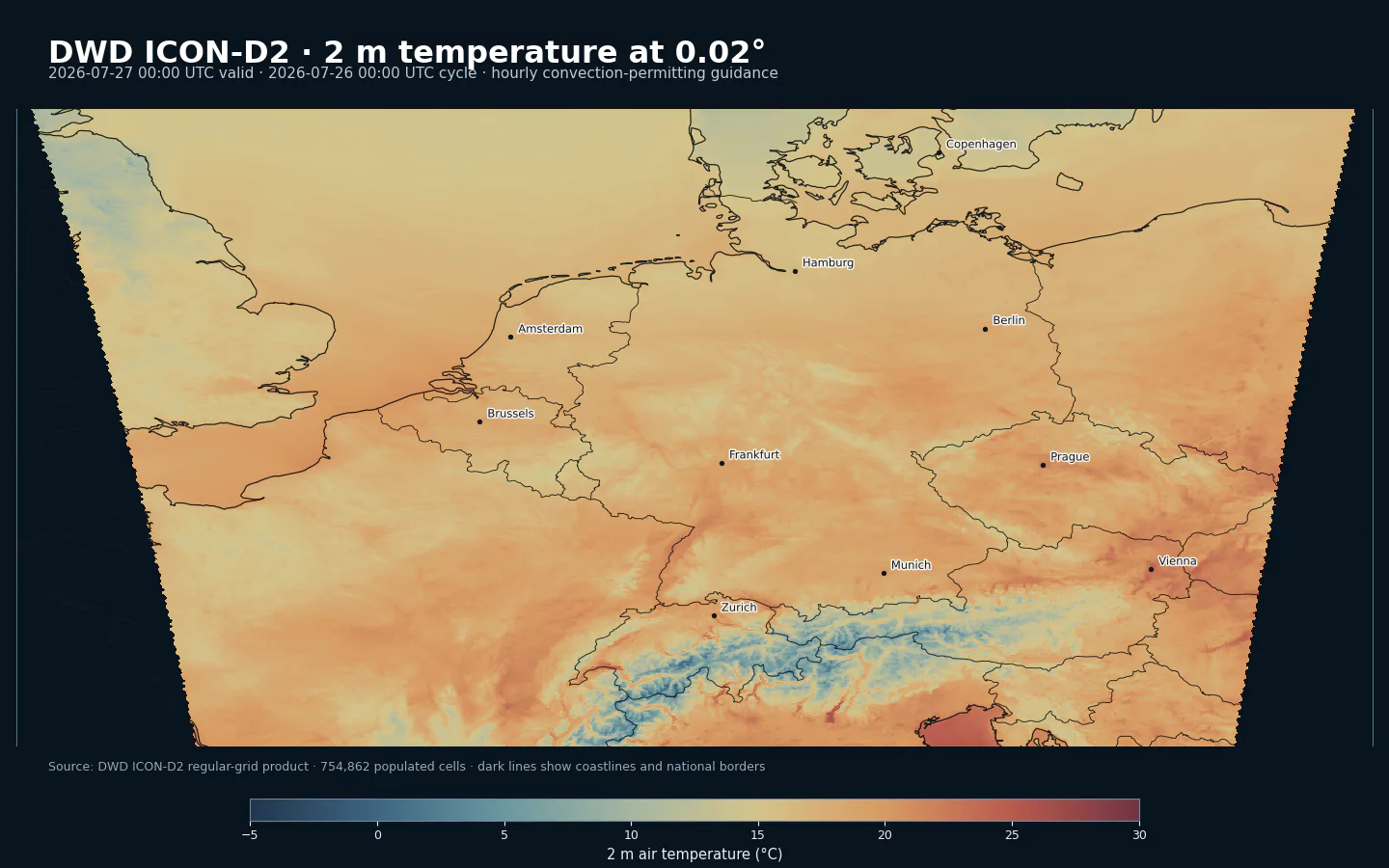
DWD's public regular-grid product spans 43.18N to 58.08N and 3.94W to 20.34E on a 0.02° latitude-longitude grid with 1,215 by 746 cells.
The populated model footprint includes Germany, the Netherlands, Belgium, Luxembourg, Switzerland, Austria, and Denmark, together with portions of France, Italy, the Czech Republic, Poland, and other neighboring areas. It covers several weather regimes within one physically consistent forecast:
- North Sea and Baltic coastal weather
- the North German Plain and major river basins
- low mountain ranges across central Germany and neighboring countries
- the Alpine arc and its Foehn-sensitive valleys
- western and central European transport and electricity corridors
The public 0.02° grid and the atmospheric model mesh describe different things. ICON-D2 performs its forecast calculations on ICON's native triangular grid at approximately 2.2 km spacing; DWD publishes this collection on a regular latitude-longitude grid for downstream use. The rectangular output envelope includes missing cells outside the valid regional footprint.
63 Fields Beyond A Basic Weather Forecast
The icond2 collection is surface-focused but scientifically broad:
| Group | Representative DWD fields | Applications |
|---|---|---|
| Near-surface state | T_2M, TD_2M, RELHUM_2M, U_10M, V_10M, PS, PMSL |
Energy demand, agriculture, transport, wind exposure, and environmental models |
| Weather and clouds | WW, VIS, CLCT, CLCL, CLCM, CLCH, CEILING |
Fog and visibility, aviation, outdoor operations, and cloud-dependent products |
| Convection and precipitation | CAPE_ML, CIN_ML, TOT_PREC, RAIN_CON, RAIN_GSP, SNOW_CON, SNOW_GSP |
Thunderstorm context, hydrology, precipitation type, and winter operations |
| Solar and surface energy | ASWDIR_S, ASWDIFD_S, ASOB_S, ATHB_S, ALHFL_S, ASHFL_S |
Solar generation, surface energy balance, agriculture, and thermal applications |
| Snow and water | H_SNOW, W_SNOW, RHO_SNOW, SNOWLMT, RUNOFF_S, RUNOFF_G |
Snowpack, road treatment, catchments, runoff, and mountain planning |
| Observation-like diagnostics | SYNMSG_BT_CL_IR10.8, SYNMSG_BT_CL_WV6.2 |
Forecast visualization and comparison with Meteosat imagery |
The synthetic brightness temperatures are calculated from the model atmosphere. They resemble selected Meteosat SEVIRI channels for comparison and diagnosis, but they are not satellite observations.
Time Meaning Matters
GribStream preserves the DWD field names and makes each field's temporal statistic explicit:
| Example | info |
Interpretation |
|---|---|---|
T_2M |
"" |
Value at the valid time |
TOT_PREC |
"acc" |
Total precipitation accumulated from the model run start |
ASWDIR_S |
"ave" |
Direct short-wave radiation flux averaged from run start to valid time |
VMAX_10M |
"max" |
Maximum 10 m wind over the source-reported interval |
TMIN_2M |
"min" |
Minimum 2 m temperature over the source-reported interval |
These distinctions prevent common analytical mistakes. Subtracting successive TOT_PREC values yields interval precipitation, while comparing two ASWDIR_S values directly compares means over different averaging periods. Maximum and minimum fields describe an interval extreme rather than an instantaneous state.
The ICON-D2 model page lists every available name, level, and info tuple together with its lead-time coverage.
Where ICON-D2 Fits
ICON-D2 is strongest when fine Central European detail and fresh initialization matter:
- use
icond2for hourly, approximately 2.2 km deterministic guidance through 48 hours - use DWD ICON-EU for broader European coverage through five days
- use Météo-France AROME for 0.01° guidance centered on France
- use DMI HARMONIE DINI for 2 km surface guidance over Northwestern Europe
- use ECMWF IFS for global context and a longer deterministic range
For decisions sensitive to exact thunderstorm location, flash flooding, peak gusts, or fog onset, combine ICON-D2 with observations and ensemble guidance. For cross-border systems, the overlap with other high-resolution regional models also supports useful model comparison.
Open Data With Attribution
DWD publishes ICON-D2 through DWD Open Data without account registration. The data may be reused commercially or non-commercially under CC BY 4.0, subject to attribution.
GribStream identifies Deutscher Wetterdienst as the creator and links to the official source. Applications that republish ICON-D2 information should preserve DWD attribution.
Start Here
- DWD ICON-D2 model page and parameter inventory
- DWD ICON-EU model page
- Météo-France AROME model page
- DMI HARMONIE DINI model page
- ECMWF IFS model page
- API documentation
Sources
- DWD numerical weather prediction data and ICON-D2 overview: https://www.dwd.de/EN/ourservices/nwp_forecast_data/nwp_forecast_data.html
- DWD ICON-D2 model documentation: https://www.dwd.de/DE/leistungen/nwv_icon_d2_modelldokumentation/nwv_icon_d2_modelldokumentation.html
- DWD ICON-D2 operational database description: https://www.dwd.de/SharedDocs/downloads/DE/modelldokumentationen/nwv/icon_d2/icon_d2_dbbeschr_aktuell.pdf?nn=344870&view=nasPublication
- DWD ICON-D2 Open Data directory: https://opendata.dwd.de/weather/nwp/icon-d2/grib/
- DWD Open Data terms: https://www.dwd.de/EN/ourservices/opendata/opendata.html
- Creative Commons Attribution 4.0 licence: https://creativecommons.org/licenses/by/4.0/legalcode