
GribStream Blog
ERA6 is in production: what changes from ERA5
ECMWF's ERA6 reanalysis brings a 14 km atmosphere, an ocean component and new variables. First public data are expected in late 2027.
ECMWF has started producing ERA6, the next global reanalysis for the Copernicus Climate Change Service (C3S). Its atmospheric grid will be approximately 14 km, compared with ERA5's 31 km, and the system adds an ocean component and a broader set of weather and climate variables.
The first public release is expected toward the end of 2027, covering production streams from 2007 onward. The longer record will follow in stages. ECMWF sets out the specifications and release plans in its ERA6 production article.
What changes from ERA5
Reanalysis combines historical observations with a consistent model and data-assimilation system to reconstruct past weather. It provides a reference for forecast verification, climate analysis and machine-learning training. ECMWF's overview of reanalysis explains why that long, coherent record matters.
ERA6 updates both the reconstruction system and the observations going into it. The main specifications in ECMWF's announcement are:
| Feature | ERA5 | ERA6 |
|---|---|---|
| Atmospheric grid | About 31 km, TL639 | About 14 km, TCo799 |
| Atmospheric vertical levels | 137 | 137 |
| IFS cycle | 41r2 | 49r2 |
| Uncertainty ensemble (EDA) | 9 members + 1 control, 63 km | 10 members + 1 control, 28 km |
| Ocean component | Prescribed sea-surface temperature and sea ice | NEMO-4 ocean and SI³ sea ice; 0.25°, 75 ocean levels |
| Snow | One layer | Five layers, plus snow on ice |
| Output format | GRIB1 and GRIB2 | GRIB2 throughout, using WMO units |
| Historical coverage | 1940 onward | Planned back to at least 1950 |
The 14 km figure describes the native atmospheric system. It does not establish the downloadable grid of every future CDS product. ERA6 retains hourly output; its EDA fields are generally three-hourly, with hourly single-level accumulations. The ensemble provides uncertainty estimates at 28 km resolution.
Better observations are as important as the grid
ERA6 draws on rescued and reprocessed satellite records as well as additional land, marine and upper-air observations. Improvements include recovering information from older satellite instruments and accounting for the drift of weather balloons during ascent. These changes matter especially for decades when the observing network was much less complete.
ECMWF reports that the additional observations improve analysis quality particularly in the southern hemisphere and the stratosphere. Revised assimilation also addresses stratospheric temperature bias. The finer grid is therefore one part of a broader scientific update: the historical evidence and the way it is combined with the model are changing too. ECMWF describes the observation and assimilation advances in its ERA6 announcement.
More useful detail near the surface
The planned catalogue includes selected parameters on 11 height levels between 15 m and 500 m above the surface. New variables include 2 m relative and specific humidity, direct normal solar radiation, sunshine duration, urban cover, reciprocal Obukhov length, three-dimensional clear-air turbulence, and specific rain and snow water content. ECMWF also lists daily and monthly statistics, including standard deviation, minimum and maximum.
For wind-resource assessment, the height levels could reduce reliance on extrapolation from a small set of standard heights. The planned direct-normal radiation field is relevant to solar-resource analysis, while humidity and boundary-layer variables could support richer demand and environmental models. These are potential applications of the announced fields; their usefulness at a particular site will need evaluation against observations.
An ocean component, with better initial conditions
ERA6 will ingest three-dimensional ocean initial conditions from ORAS6 twice daily, alongside its atmosphere, land and wave components. ORAS6 uses 3D-Var assimilation with satellite and in-situ ocean observations. The planned ERA6 products include both two-dimensional and three-dimensional ocean fields.
The scientific benefit is a more physically consistent representation of conditions across the air–sea boundary, including exchanges that influence the marine atmosphere. ECMWF's ocean data-assimilation article explains how ensemble information lets uncertainty estimates evolve with the ocean state. It reports reduced sea-surface-temperature bias compared with the older ORAS5 approach. This broader ocean record could support studies of marine conditions and their relationship to weather and climate.
Storm Egon shows the potential
ECMWF illustrates the change with windstorm Egon near Dieppe, France, at 20 UTC on January 12, 2017. Its reported maximum gust is 38.7 m/s in ERA6, compared with 32.7 m/s in ERA5 and an observed maximum of 40.6 m/s.
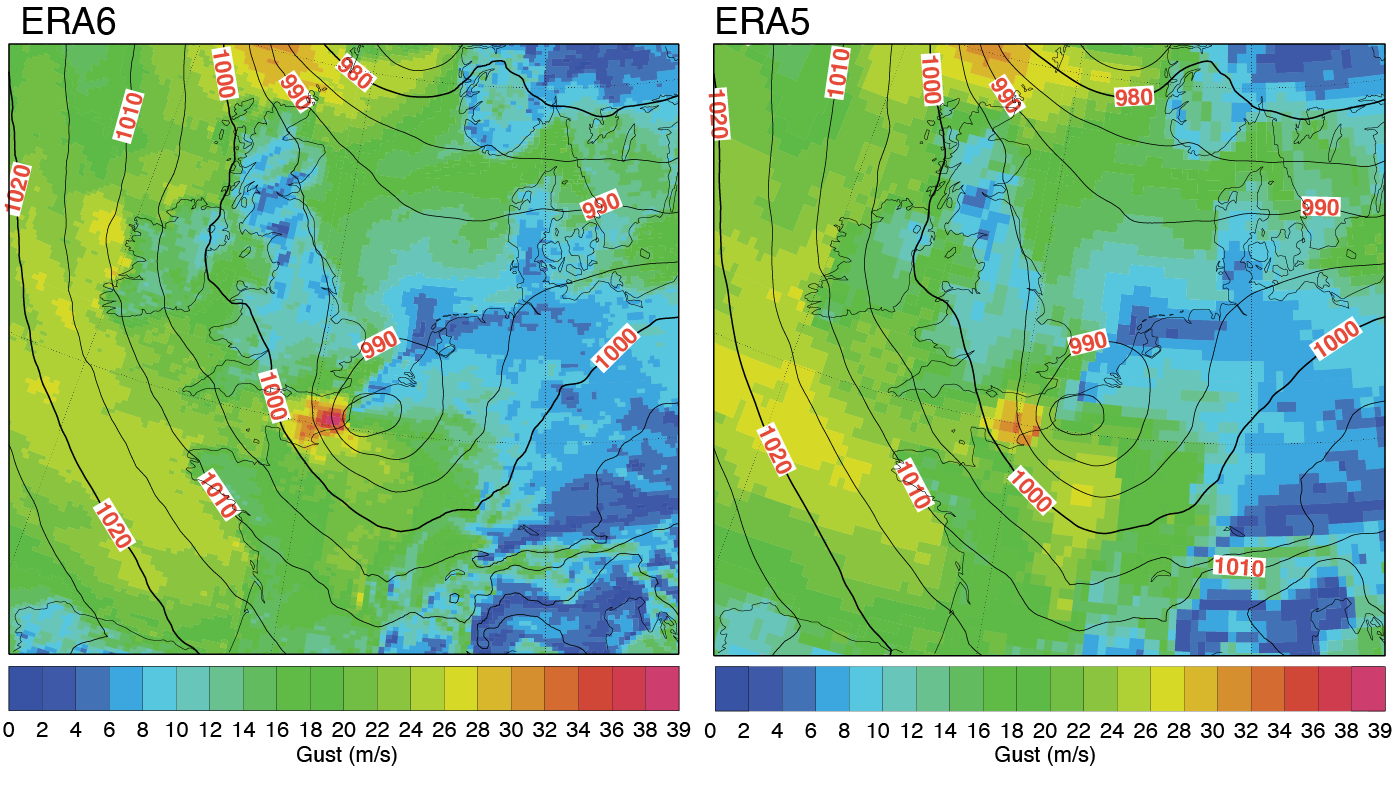
This case shows a closer match to the observed peak. It is not a universal error reduction for every storm, variable or location. For a weather-impact backtest, the useful question is how changes in event intensity and timing affect the result across a representative sample.
Why the release will arrive in stages
ECMWF is processing ten-year streams in parallel, each with a preceding year of spin-up to reduce discontinuities in components with long memory. Streams beginning in 2007 and 2017 are running; 1987 and 1997 are planned to follow. Each stream is expected to take slightly more than a year to complete.
The late-2027 target concerns the first published streams, not the full historical archive. The planned record reaches back to at least 1950, whereas ERA5 includes the 1940s. ECMWF also plans to replace ERA5T after sufficient ERA6 data have been published, but the transition date and ERA6T latency remain unconfirmed.
Why ERA6 matters for weather-data users
A reanalysis is the historical reference behind many weather-dependent decisions. Changes in wind extremes, surface radiation or humidity can alter an assessment of a site's exposure, an energy-resource estimate or the weather features used in a demand model. ERA6's finer grid and expanded variables create opportunities to revisit those analyses with more detail. Local observations remain essential for judging how well a grid represents a particular site.
For forecast verification and machine learning, the transition also changes the reference used to score forecasts or train models. ERA5 and ERA6 will need comparison over shared periods with consistent units, accumulation windows and spatial sampling. A better historical reconstruction can change a forecast score even when the forecast itself is unchanged; recording the reanalysis version makes those results reproducible.
For work that needs historical data today, the ERA5 model page on GribStream describes the available archive. ERA6's first public data are expected in late 2027, and no GribStream release date has been announced. As of September 6, 2026, the CDS catalogue has no ERA6 collection; the final distribution catalogue and dataset licence remain to be confirmed.
Sources
- Hersbach et al.: ERA6 reanalysis is in production, ECMWF Newsletter 188; main source for specifications, production status and timing.
- ECMWF Newsletter No. 188 — Summer 2026, publication metadata dated August 2026.
- Summer 2026 Newsletter published, ECMWF announcement dated September 4, 2026.
- Reanalysis: past, present and future, ECMWF background.
- Advancing ocean data assimilation for climate reanalyses, ECMWF ocean-system context.
- Copernicus Climate Data Store catalogue, checked September 6, 2026.