
GribStream Blog
Snowpack, soil saturation, and evapotranspiration at 1 km
NOAA National Water Model short-range land forecasts bring hourly snowpack, near-surface soil saturation, and evapotranspiration guidance to GribStream on a 1 km CONUS+ grid.
The National Water Model (NWM) is best known for river-flow forecasts, but its view of the water cycle begins on the land surface. Before water reaches a channel, snow accumulates and melts, soil wets or dries, and moisture returns to the atmosphere through evapotranspiration.
The new nwmshortland dataset brings that land-surface forecast to GribStream on NOAA's 1 km CONUS+ grid. A new deterministic cycle is produced every hour, with hourly forecast lead times from 1 through 18 hours.
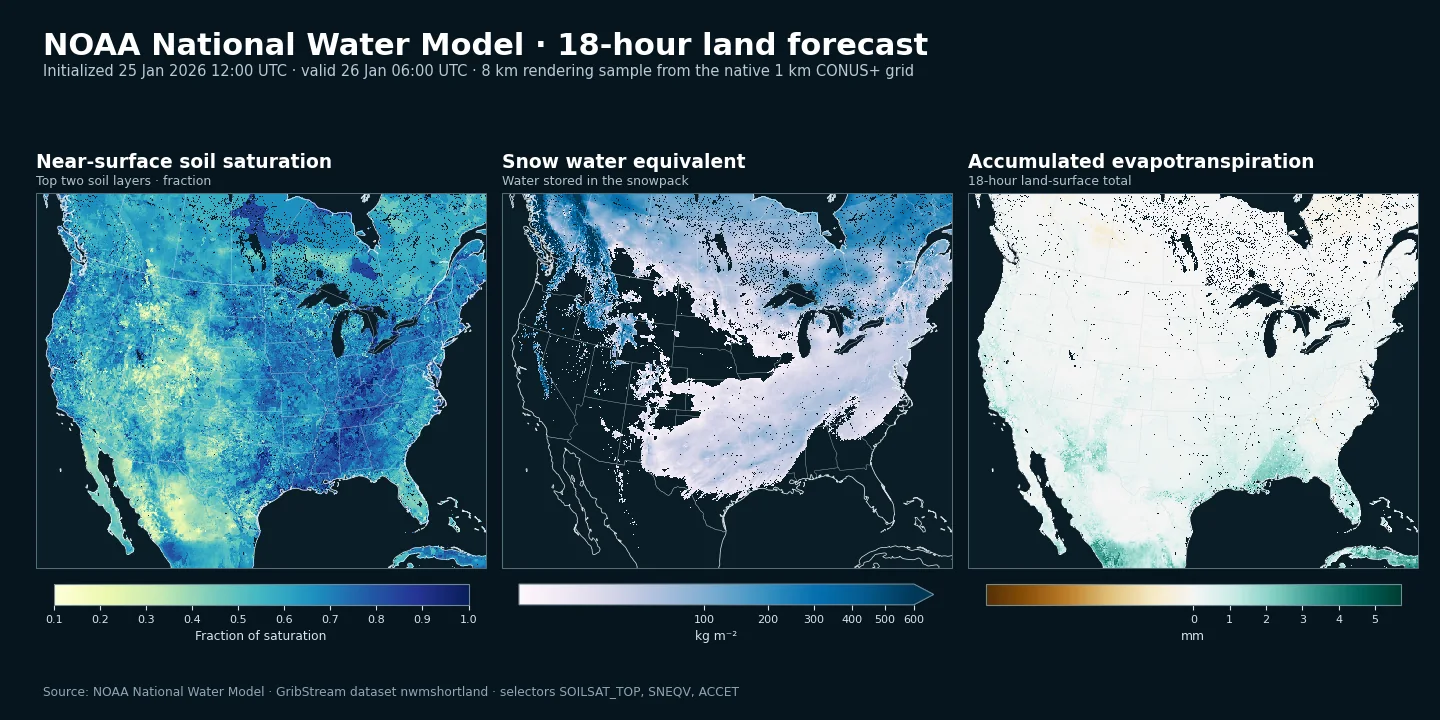
Six fields that describe the land-water state
Each short-range land file contains six source variables:
SOILSAT_TOP— the fraction of saturation in the top two soil layers, representing approximately the upper 0.4 m.SNEQV— snow water equivalent, or the amount of liquid water stored in the snowpack.SNOWH— physical snow depth.FSNO— the fraction of the ground covered by snow.SNOWT_AVG— average snow temperature weighted by snow-layer mass.ACCET— total evapotranspiration accumulated during the forecast.
Together they provide a compact description of current and near-future land conditions. Snow depth alone does not tell how much water the pack contains; soil saturation adds context for infiltration and runoff; evapotranspiration shows one route by which water leaves the land surface.
A high-resolution forecast that refreshes hourly
The grid contains 4,608 by 3,840 cells in a Lambert conformal projection. It covers the contiguous United States and adjacent contributing areas of Canada and Mexico, with 1 km spacing throughout the domain.
Hourly cycles and overlapping lead times are valuable for operational monitoring. The same valid hour can appear in several runs, making it possible to follow how the forecast changes as new forcing and model states arrive. The 18-hour horizon is intentionally short: this dataset emphasizes the land surface's immediate evolution rather than long-range hydrologic outlooks.
The land component uses Noah-MP, the land-surface model within NWM, to represent exchanges of water and energy among soil, vegetation, snow, and the atmosphere. Weather context can be added with HRRR, while MRMS provides radar and multi-sensor precipitation analyses.
What this dataset is—and is not
nwmshortland is the regular land grid. It does not contain NWM's separate channel-routing, reservoir, or higher-resolution terrain-routing outputs, and it should not be described as a streamflow dataset. Its strength is spatial analysis of land and snow conditions across watersheds, agricultural regions, mountain ranges, and transportation corridors.
Useful applications include snowpack and melt monitoring, soil-wetness dashboards, agricultural water management, watershed situational awareness, winter operations, and comparison of consecutive short-range hydrologic forecasts.
GribStream currently indexes compatible source objects from January 1, 2025 onward. NOAA describes the AWS source as a rolling four-week archive, although older objects are presently retained; availability beyond that stated source window should therefore be treated as opportunistic rather than guaranteed permanent history. Missing cycles, operational delays, and future NWM upgrades may also create gaps.
The NWM short-range land inventory lists the exact selectors, levels, units, lead times, and currently indexed dates.
Authoritative sources:
- NOAA National Water Model overview: https://water.noaa.gov/about/nwm
- NOAA NWM output-file contents: https://water.noaa.gov/about/output_file_contents
- NOAA NWM Registry of Open Data on AWS: https://registry.opendata.aws/noaa-nwm-pds/