
GribStream Blog
SMN WRF joins GribStream: 4 km weather forecasts for Argentina and neighboring countries
SMN WRF brings 72-hour forecasts, 10-minute rainfall, soil conditions and radiation to GribStream for Argentina and southern South America.
SMN WRF is now available in GribStream: 4 km weather forecasts for Argentina and southern South America, four times a day, through 72 hours. The dataset combines hourly surface weather with ten-minute rainfall and daily temperature extremes. It includes all 14 published weather variables, with 15 parameter and statistic combinations.
From the Andes to the Río de la Plata
The forecast is produced by Argentina’s Servicio Meteorológico Nacional (SMN). Its domain covers Argentina, Chile, Uruguay and Paraguay, parts of Bolivia and Brazil, and adjacent Pacific and Atlantic waters. That makes it useful for projects spanning national borders: a catchment in the La Plata Basin, a network of farms across the Pampas, or transport routes crossing the Andes.
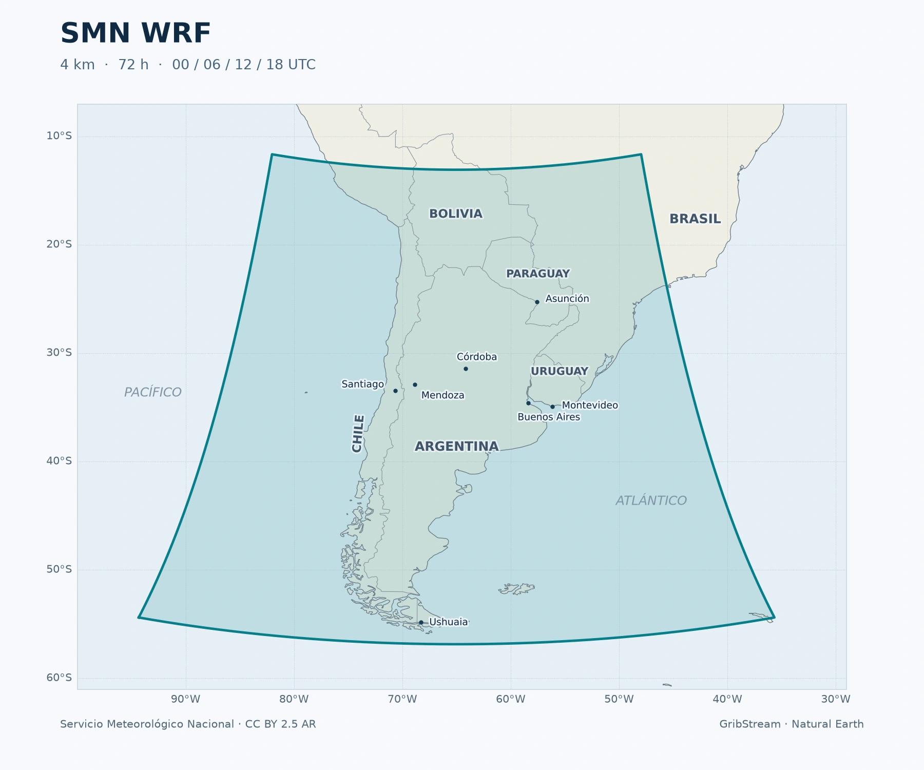
The shaded footprint follows the forecast grid’s outer cell centres. Coverage map by GribStream; SMN grid, CC BY 2.5 Argentina; Natural Earth boundaries.
What 4 km resolution adds
SMN runs a regional configuration of WRF-ARW, initialized and driven at its boundaries by NOAA’s GFS. The model represents convection explicitly on a 4 km grid, giving it a finer representation of terrain and regional weather contrasts than the driving global forecast. SMN’s technical description details the cloud, boundary-layer, radiation and land-surface physics.
For a user, that detail matters when comparing rainfall on either side of a mountain range, temperature across agricultural districts, or wind along a coast. It still leaves uncertainty in the exact position and timing of storms. SMN WRF is a deterministic forecast, not an ensemble probability product.
Rainfall, agriculture and energy
The published variables cover several practical workflows:
- Rainfall timing: hourly and ten-minute accumulations. Each ten-minute value describes the preceding interval; it is forecast precipitation, not a radar observation.
- Crop and irrigation planning: temperature and humidity at 2 m, rainfall, and soil temperature and moisture in the upper 0–10 cm. Daily minimum and maximum temperatures help screen for frost and heat alongside local observations.
- Solar generation: downward shortwave radiation and temperature as inputs to a site model. Radiation is accumulated energy in J/m²; differences over an interval give its average power when divided by elapsed seconds.
- Regional operations: 10 m wind speed and direction, surface pressure and freezing-level altitude. Wind-power calculations need a separate treatment of hub height.
The four forecast initializations are 00, 06, 12 and 18 UTC. Daily minimum temperature covers 00–12 UTC and maximum temperature covers 12–24 UTC; these intervals are distinct from a local calendar day. The model page explains the units, timing and complete parameter inventory.
Access and history
The GribStream dataset code is smnwrf. Use the model inventory to select variables, then request locations through the same time-series and forecast-run API used for other models.
SMN’s source archive begins on 1 January 2022, with additional fields and forecast cycles introduced during 2023. GribStream includes the available historical runs from January 2022. Missing source periods and fields remain gaps. SMN product history.