Accumulated downwelling longwave radiation (J m-2).

GribStream
GribStream Code: smnwrf
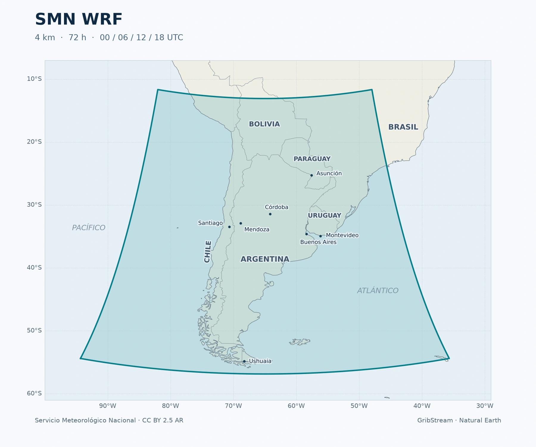
Forecasts and available historical runs from 1 January 2022. Parameter coverage changes with date; source gaps remain.
SMN WRF is the deterministic regional forecast from Argentina’s Servicio Meteorológico Nacional. Its domain covers Argentina, Chile, Uruguay and Paraguay, parts of Bolivia and Brazil, and adjacent Pacific and Atlantic waters. The 4 km grid provides a regional view of weather across the Andes, Pampas, Patagonia and Río de la Plata.
SMN documents a WRF-ARW 4.0 configuration with 45 atmospheric levels and a model top at 10 hPa. Initial and boundary conditions come from NOAA’s 0.25° GFS. Convection is represented explicitly: the model can develop storm-scale circulations on its grid, while smaller-scale cloud processes still require physical parameterizations. The published setup uses WSM6 cloud microphysics, MYJ boundary-layer physics, RRTM longwave radiation, Dudhia shortwave radiation and the four-layer Noah land-surface model. SMN model configuration.
A 4 km grid can represent terrain and local contrasts more finely than the driving global model. It does not make a forecast exact at an individual field or guarantee the location and timing of a thunderstorm. This is one deterministic forecast; it does not supply ensemble probabilities.
Temperature is in °C, wind speed in m/s, precipitation in mm and surface pressure in hPa. Radiation variables are energy accumulated since the forecast began, in J/m²; differences between successive values divided by elapsed seconds give interval-mean W/m². SMN supplies calibrated temperature and wind products when available.
Daily Tmin covers 00–12 UTC and Tmax covers 12–24 UTC. Their date label is midnight UTC, rather than the end of the interval. These are not local-calendar-day extrema. See the official variable definitions and the complete selector inventory below.
The source archive begins on 1 January 2022. Radiation, soil variables and 10-minute precipitation were added in January 2023; 06/18 UTC runs in June; freezing level in September. Historical parameter coverage therefore changes with date. Historical runs from January 2022 are available through GribStream; missing source periods and fields remain gaps. SMN product history.
Weather data: Servicio Meteorológico Nacional, CC BY 2.5 Argentina. Retain attribution and the licence link, and identify changes when redistributing derived material. Compare the regional forecast with GFS for the larger-scale weather pattern, or use the API documentation to request locations and variables.
Click a parameter to reveal variants in a compact table with ready-to-copy JSON selectors.
Accumulated downwelling longwave radiation (J m-2).
| Level | Info | Horizon | Introduced | Selector |
|---|---|---|---|---|
surface |
accumulation since forecast start |
0m-73h | 2023-01-01 |
{"name":"ACLWDNB","level":"surface","info":"accumulation since forecast start"}
|
Accumulated upwelling longwave radiation (J m-2).
| Level | Info | Horizon | Introduced | Selector |
|---|---|---|---|---|
surface |
accumulation since forecast start |
0m-73h | 2023-01-01 |
{"name":"ACLWUPB","level":"surface","info":"accumulation since forecast start"}
|
Accumulated downwelling shortwave radiation (J m-2).
| Level | Info | Horizon | Introduced | Selector |
|---|---|---|---|---|
surface |
accumulation since forecast start |
0m-73h | 2023-01-01 |
{"name":"ACSWDNB","level":"surface","info":"accumulation since forecast start"}
|
Altitude of the zero Celsius isotherm (m).
| Level | Info | Horizon | Introduced | Selector |
|---|---|---|---|---|
mean sea level |
0m-73h | 2023-09-01 |
{"name":"Freezing_level","level":"mean sea level","info":""}
|
Relative humidity (percent).
| Level | Info | Horizon | Introduced | Selector |
|---|---|---|---|---|
2 m above ground |
0m-73h | 2022-01-01 |
{"name":"HR2","level":"2 m above ground","info":""}
|
Precipitation during the preceding hour (millimeter).
| Level | Info | Horizon | Introduced | Selector |
|---|---|---|---|---|
surface |
1 hour accumulation |
0m-73h | 2022-01-01 |
{"name":"PP","level":"surface","info":"1 hour accumulation"}
|
surface |
10 minute accumulation |
0m-73h50m | 2023-01-01 |
{"name":"PP","level":"surface","info":"10 minute accumulation"}
|
Surface pressure (hPa).
| Level | Info | Horizon | Introduced | Selector |
|---|---|---|---|---|
surface |
0m-73h | 2023-01-01 |
{"name":"PSFC","level":"surface","info":""}
|
Soil water content by volume (m3 m-3).
| Level | Info | Horizon | Introduced | Selector |
|---|---|---|---|---|
0-10 cm below ground |
0m-73h | 2023-01-01 |
{"name":"SMOIS","level":"0-10 cm below ground","info":""}
|
Temperature, calibrated when available (degree_Celsius).
| Level | Info | Horizon | Introduced | Selector |
|---|---|---|---|---|
2 m above ground |
0m-73h | 2022-01-01 |
{"name":"T2","level":"2 m above ground","info":""}
|
Soil temperature (degree_Celsius).
| Level | Info | Horizon | Introduced | Selector |
|---|---|---|---|---|
0-10 cm below ground |
0m-73h | 2023-01-01 |
{"name":"TSLB","level":"0-10 cm below ground","info":""}
|
Maximum temperature for the labeled UTC day's 12-24 interval (degree_Celsius).
| Level | Info | Horizon | Introduced | Selector |
|---|---|---|---|---|
2 m above ground |
maximum 12-24 UTC |
-18h-72h | 2022-01-01 |
{"name":"Tmax","level":"2 m above ground","info":"maximum 12-24 UTC"}
|
Minimum temperature for the labeled UTC day's 00-12 interval (degree_Celsius).
| Level | Info | Horizon | Introduced | Selector |
|---|---|---|---|---|
2 m above ground |
minimum 00-12 UTC |
0m-72h | 2022-01-01 |
{"name":"Tmin","level":"2 m above ground","info":"minimum 00-12 UTC"}
|
Direction from which the wind blows (degree).
| Level | Info | Horizon | Introduced | Selector |
|---|---|---|---|---|
10 m above ground |
0m-73h | 2022-01-01 |
{"name":"dirViento10","level":"10 m above ground","info":""}
|
Wind speed, calibrated when available (meter / second).
| Level | Info | Horizon | Introduced | Selector |
|---|---|---|---|---|
10 m above ground |
0m-73h | 2022-01-01 |
{"name":"magViento10","level":"10 m above ground","info":""}
|
No parameters match your search.