Significant wave height represents the average height of the highest third of waves. It is the standard metric for sea state and marine hazards.
- Units: m.
gefswaveprob
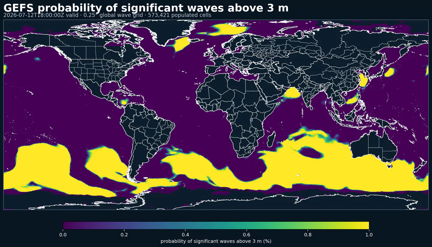
GEFS Wave Prob turns ensemble spread into ocean-wave probabilities. Instead of relying on one predicted wave height, it answers questions such as how likely a location is to exceed an operational wave-height threshold.
That matters for maritime routing, offshore work, ports, coastal planning, and recreational marine safety because the cost of underestimating waves is often asymmetric. A moderate probability of hazardous sea state can change route selection, work windows, or required safety margins.
Click a parameter to reveal variants in a compact table with ready-to-copy JSON selectors.
Significant wave height represents the average height of the highest third of waves. It is the standard metric for sea state and marine hazards.
| Level | Info | Horizon | Introduced | Selector |
|---|---|---|---|---|
surface |
prob >0.6 |
0h-384h | 2020-10-01 |
{"name":"HTSGW","level":"surface","info":"prob >0.6"}
|
surface |
prob >1 |
0h-384h | 2020-10-01 |
{"name":"HTSGW","level":"surface","info":"prob >1"}
|
surface |
prob >2 |
0h-384h | 2020-10-01 |
{"name":"HTSGW","level":"surface","info":"prob >2"}
|
surface |
prob >3 |
0h-384h | 2020-10-01 |
{"name":"HTSGW","level":"surface","info":"prob >3"}
|
surface |
prob >4 |
0h-384h | 2020-10-01 |
{"name":"HTSGW","level":"surface","info":"prob >4"}
|
surface |
prob >5.5 |
0h-384h | 2020-10-01 |
{"name":"HTSGW","level":"surface","info":"prob >5.5"}
|
surface |
prob >7 |
0h-384h | 2020-10-01 |
{"name":"HTSGW","level":"surface","info":"prob >7"}
|
surface |
prob >9 |
0h-384h | 2020-10-01 |
{"name":"HTSGW","level":"surface","info":"prob >9"}
|
Primary Wave Mean Period (seconds).
| Level | Info | Horizon | Introduced | Selector |
|---|---|---|---|---|
surface |
prob >11 |
0h-384h | 2020-10-01 |
{"name":"PERPW","level":"surface","info":"prob >11"}
|
surface |
prob >13 |
0h-384h | 2020-10-01 |
{"name":"PERPW","level":"surface","info":"prob >13"}
|
surface |
prob >15 |
0h-384h | 2020-10-01 |
{"name":"PERPW","level":"surface","info":"prob >15"}
|
surface |
prob >17 |
0h-384h | 2020-10-01 |
{"name":"PERPW","level":"surface","info":"prob >17"}
|
surface |
prob >19 |
0h-384h | 2020-10-01 |
{"name":"PERPW","level":"surface","info":"prob >19"}
|
surface |
prob >5 |
0h-384h | 2020-10-01 |
{"name":"PERPW","level":"surface","info":"prob >5"}
|
surface |
prob >7 |
0h-384h | 2020-10-01 |
{"name":"PERPW","level":"surface","info":"prob >7"}
|
surface |
prob >9 |
0h-384h | 2020-10-01 |
{"name":"PERPW","level":"surface","info":"prob >9"}
|
Significant Height of Swell Waves (meters).
| Level | Info | Horizon | Introduced | Selector |
|---|---|---|---|---|
surface |
prob >0.6 |
0h-384h | 2020-10-01 |
{"name":"SWELL","level":"surface","info":"prob >0.6"}
|
surface |
prob >1 |
0h-384h | 2020-10-01 |
{"name":"SWELL","level":"surface","info":"prob >1"}
|
surface |
prob >2 |
0h-384h | 2020-10-01 |
{"name":"SWELL","level":"surface","info":"prob >2"}
|
surface |
prob >3 |
0h-384h | 2020-10-01 |
{"name":"SWELL","level":"surface","info":"prob >3"}
|
surface |
prob >4 |
0h-384h | 2020-10-01 |
{"name":"SWELL","level":"surface","info":"prob >4"}
|
surface |
prob >5.5 |
0h-384h | 2020-10-01 |
{"name":"SWELL","level":"surface","info":"prob >5.5"}
|
surface |
prob >7 |
0h-384h | 2020-10-01 |
{"name":"SWELL","level":"surface","info":"prob >7"}
|
surface |
prob >9 |
0h-384h | 2020-10-01 |
{"name":"SWELL","level":"surface","info":"prob >9"}
|
Mean Period of Swell Waves (seconds).
| Level | Info | Horizon | Introduced | Selector |
|---|---|---|---|---|
surface |
prob >11 |
0h-384h | 2020-10-01 |
{"name":"SWPER","level":"surface","info":"prob >11"}
|
surface |
prob >13 |
0h-384h | 2020-10-01 |
{"name":"SWPER","level":"surface","info":"prob >13"}
|
surface |
prob >15 |
0h-384h | 2020-10-01 |
{"name":"SWPER","level":"surface","info":"prob >15"}
|
surface |
prob >17 |
0h-384h | 2020-10-01 |
{"name":"SWPER","level":"surface","info":"prob >17"}
|
surface |
prob >19 |
0h-384h | 2020-10-01 |
{"name":"SWPER","level":"surface","info":"prob >19"}
|
surface |
prob >5 |
0h-384h | 2020-10-01 |
{"name":"SWPER","level":"surface","info":"prob >5"}
|
surface |
prob >7 |
0h-384h | 2020-10-01 |
{"name":"SWPER","level":"surface","info":"prob >7"}
|
surface |
prob >9 |
0h-384h | 2020-10-01 |
{"name":"SWPER","level":"surface","info":"prob >9"}
|
Wind speed is the magnitude of the horizontal wind at the specified level. It is used for transport, mixing, and hazards.
| Level | Info | Horizon | Introduced | Selector |
|---|---|---|---|---|
surface |
prob >11.31 |
0h-384h | 2020-10-01 |
{"name":"WIND","level":"surface","info":"prob >11.31"}
|
surface |
prob >14.39 |
0h-384h | 2020-10-01 |
{"name":"WIND","level":"surface","info":"prob >14.39"}
|
surface |
prob >17.48 |
0h-384h | 2020-10-01 |
{"name":"WIND","level":"surface","info":"prob >17.48"}
|
surface |
prob >21.07 |
0h-384h | 2020-10-01 |
{"name":"WIND","level":"surface","info":"prob >21.07"}
|
surface |
prob >24.67 |
0h-384h | 2020-10-01 |
{"name":"WIND","level":"surface","info":"prob >24.67"}
|
surface |
prob >3.6 |
0h-384h | 2020-10-01 |
{"name":"WIND","level":"surface","info":"prob >3.6"}
|
surface |
prob >5.65 |
0h-384h | 2020-10-01 |
{"name":"WIND","level":"surface","info":"prob >5.65"}
|
surface |
prob >8.74 |
0h-384h | 2020-10-01 |
{"name":"WIND","level":"surface","info":"prob >8.74"}
|
Significant Height of Wind Waves (meters).
| Level | Info | Horizon | Introduced | Selector |
|---|---|---|---|---|
surface |
prob >0.6 |
0h-384h | 2020-10-01 |
{"name":"WVHGT","level":"surface","info":"prob >0.6"}
|
surface |
prob >1 |
0h-384h | 2020-10-01 |
{"name":"WVHGT","level":"surface","info":"prob >1"}
|
surface |
prob >2 |
0h-384h | 2020-10-01 |
{"name":"WVHGT","level":"surface","info":"prob >2"}
|
surface |
prob >3 |
0h-384h | 2020-10-01 |
{"name":"WVHGT","level":"surface","info":"prob >3"}
|
surface |
prob >4 |
0h-384h | 2020-10-01 |
{"name":"WVHGT","level":"surface","info":"prob >4"}
|
surface |
prob >5.5 |
0h-384h | 2020-10-01 |
{"name":"WVHGT","level":"surface","info":"prob >5.5"}
|
surface |
prob >7 |
0h-384h | 2020-10-01 |
{"name":"WVHGT","level":"surface","info":"prob >7"}
|
surface |
prob >9 |
0h-384h | 2020-10-01 |
{"name":"WVHGT","level":"surface","info":"prob >9"}
|
Mean Period of Wind Waves (seconds).
| Level | Info | Horizon | Introduced | Selector |
|---|---|---|---|---|
surface |
prob >11 |
0h-384h | 2020-10-01 |
{"name":"WVPER","level":"surface","info":"prob >11"}
|
surface |
prob >13 |
0h-384h | 2020-10-01 |
{"name":"WVPER","level":"surface","info":"prob >13"}
|
surface |
prob >15 |
0h-384h | 2020-10-01 |
{"name":"WVPER","level":"surface","info":"prob >15"}
|
surface |
prob >17 |
0h-384h | 2020-10-01 |
{"name":"WVPER","level":"surface","info":"prob >17"}
|
surface |
prob >19 |
0h-384h | 2020-10-01 |
{"name":"WVPER","level":"surface","info":"prob >19"}
|
surface |
prob >5 |
0h-384h | 2020-10-01 |
{"name":"WVPER","level":"surface","info":"prob >5"}
|
surface |
prob >7 |
0h-384h | 2020-10-01 |
{"name":"WVPER","level":"surface","info":"prob >7"}
|
surface |
prob >9 |
0h-384h | 2020-10-01 |
{"name":"WVPER","level":"surface","info":"prob >9"}
|
No parameters match your search.