Global longwave infrared imagery value (source scale 0-255) (1).

GribStream
GribStream Code: gmgsi
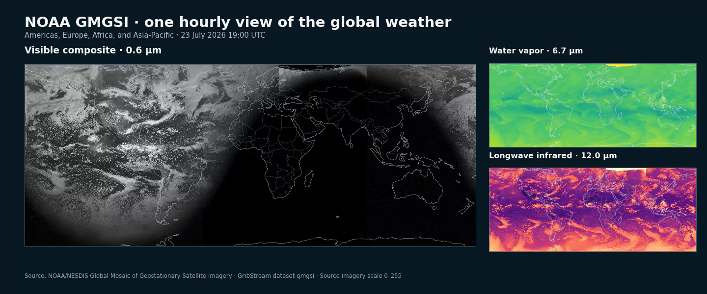
Current archive: GribStream coverage begins July 22, 2026 at 15:00 UTC on NOAA's current fixed 4,999 by 3,000 GMGSI grid. These are observations, not forecasts; horizon is 0.
Composite imagery: NOAA blends observations from the geostationary satellites covering the Americas, Europe and Africa, and Asia-Pacific. Satellite viewing geometry, calibration, scan timing, and stitching can make seams or regional differences visible.
Availability and open data: source outages, satellite operations, and product transitions can create gaps. NOAA data distributed through its Open Data program are available for public use; attribution is requested and NOAA endorsement must not be implied.
GMGSI combines multiple operational geostationary satellites into one hourly world mosaic. It provides a single spatial frame for weather systems that cross the boundaries of individual GOES, Meteosat, and Himawari views.
The visible channel shows daylight cloud cover, surface contrast, snow, and ice. Shortwave infrared highlights cloud cover and fog at night, water vapor represents moisture in the mid-to-upper troposphere, and longwave infrared shows cloud cover and broad land and sea temperature patterns by day and night.
Values retain NOAA's source imagery scale from 0 to 255. They support consistent rendering and relative pattern comparisons within each channel, but they are not reflectance percentages or brightness temperatures expressed in physical units and should not be compared numerically across channels.
The inventory below lists the four exact selectors, wavelengths, and archive dates. The polar regions beyond approximately 72.7 degrees latitude are outside this mosaic.
GMGSI_VIS at 0.6 um, GMGSI_SIR at 3.8 um, GMGSI_WV at 6.7 um, and GMGSI_LIR at 12.0 um.Click a parameter to reveal variants in a compact table with ready-to-copy JSON selectors.
Global longwave infrared imagery value (source scale 0-255) (1).
| Level | Info | Horizon | Introduced | Selector |
|---|---|---|---|---|
top of atmosphere |
12.0 um |
0h | 2026-07-22 |
{"name":"GMGSI_LIR","level":"top of atmosphere","info":"12.0 um"}
|
Global shortwave infrared imagery value (source scale 0-255) (1).
| Level | Info | Horizon | Introduced | Selector |
|---|---|---|---|---|
top of atmosphere |
3.8 um |
0h | 2026-07-22 |
{"name":"GMGSI_SIR","level":"top of atmosphere","info":"3.8 um"}
|
Global visible imagery value (source scale 0-255) (1).
| Level | Info | Horizon | Introduced | Selector |
|---|---|---|---|---|
top of atmosphere |
0.6 um |
0h | 2026-07-22 |
{"name":"GMGSI_VIS","level":"top of atmosphere","info":"0.6 um"}
|
Global mid- to upper-tropospheric water-vapor imagery value (source scale 0-255) (1).
| Level | Info | Horizon | Introduced | Selector |
|---|---|---|---|---|
top of atmosphere |
6.7 um |
0h | 2026-07-22 |
{"name":"GMGSI_WV","level":"top of atmosphere","info":"6.7 um"}
|
No parameters match your search.