
GribStream Blog
27 GOES-19 ABI satellite fields now on GribStream
Query 27 fields across two fixed-grid GOES-19 ABI datasets: one at about 2 km and one at about 10 km at nadir.
Update (July 20, 2026): the two datasets have expanded from 27 to 61 fields, adding cloud properties, atmospheric stability, smoke, dust, snow, reflected radiation, and land-surface observations. Read the expansion announcement.
GribStream's first GOES canary has expanded into two broader satellite-observation datasets. goes19abi provides 24 fields from six NOAA GOES-19 Advanced Baseline Imager full-disk Level 2 products on the native 2 km grid. goes19abi10km provides three fields from three more Level 2 products on the native 10 km grid.
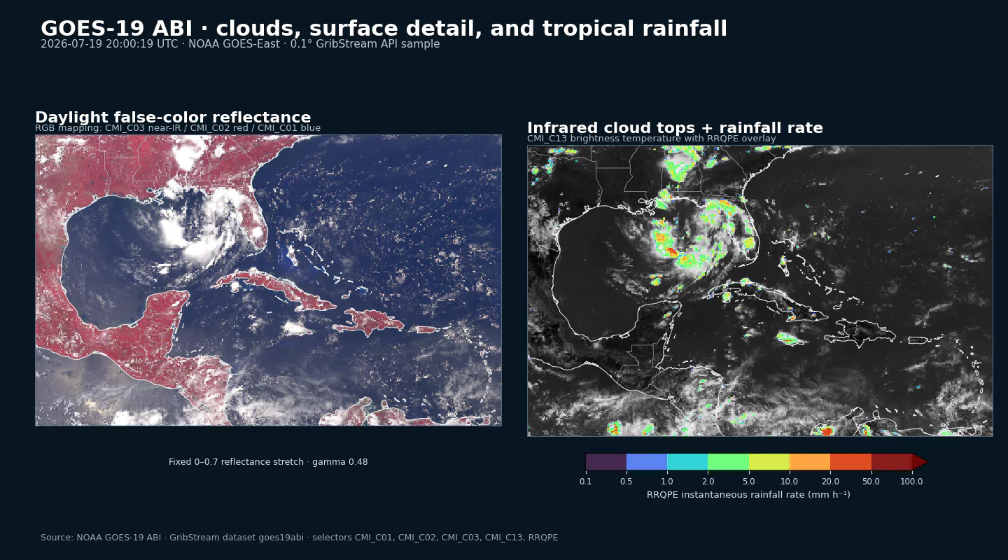
Together they span 16-band cloud and moisture imagery, fire detection and characterization, aerosol optical depth, downward shortwave radiation, rainfall rate, total precipitable water, cloud-top height, land-surface temperature, and sea-surface temperature. The two dataset codes keep each source-native fixed grid explicit while preserving NOAA field names, units, and observation times.
What is available
| NOAA ABI source product | GribStream fields | Sampling at nadir | Typical full-disk interval |
|---|---|---|---|
| Multiband Cloud and Moisture Imagery | CMI_C01 through CMI_C16 |
About 2 km | About 10 minutes |
| Fire Detection and Characterization | Mask, Power, Temp, Area |
About 2 km | About 10 minutes |
| Aerosol Optical Depth | AOD |
About 2 km | About 10 minutes |
| Downward Shortwave Radiation | DSR |
About 2 km | About 10 minutes |
| Rainfall Rate QPE | RRQPE |
About 2 km | About 10 minutes |
| Total Precipitable Water | TPW |
About 10 km | About 10 minutes |
| Cloud-Top Height | HT |
About 10 km | About 10 minutes |
| Land-Surface Temperature | LST |
About 10 km | Hourly |
| Sea-Surface Temperature | SST |
About 2 km | Hourly |
All nine source products are observation-derived analyses with horizon equal to 0. Eight begin April 8, 2025, the first full UTC day after GOES-19 entered operational service in the GOES-East slot. The four FDCF fire fields begin July 10, 2026; earlier FDCF scans are not currently included.
RRQPE is now part of goes19abi. The original goes19rrqpef dataset code remains readable as a compatibility alias, but new integrations should use the 2 km collection.
From calibrated imagery to application-focused observations
ABI observes the GOES-East disk in 16 spectral bands. CMI_C01 through CMI_C06 expose reflectance from visible and near-infrared channels, while CMI_C07 through CMI_C16 expose infrared brightness temperatures in K. Together they support cloud structure, fog, water-vapor, convection, surface, and storm analysis.
The Level 2 products derive more targeted quantities from those calibrated observations. Fire fields describe detection categories, radiative power, estimated temperature, and area. AOD characterizes aerosol loading; DSR estimates solar radiation reaching the surface; RRQPE estimates rainfall rate; TPW summarizes atmospheric-column water; HT estimates cloud-top height; and LST and SST describe land and ocean skin temperatures.
That combination makes the dataset useful across several workflows: tropical-cyclone and convective monitoring, wildfire and smoke context, solar-energy operations, moisture analysis, cloud-height estimation, and land or ocean temperature tracking.
Explore the field inventories
The 2 km inventory and 10 km inventory list the available fields, units, and coverage periods. Exact observation times can differ among fields because NOAA publishes the underlying ABI products on different schedules.
Interpretation and availability limits
Satellite retrievals are not direct ground measurements. Several products depend on daylight, clear-sky conditions, cloud screening, or assumptions about atmospheric and surface properties. Spatial footprints become larger and retrieval quality can decline toward the edge of the visible disk. Fire detections should be confirmed with incident information, and aerosol or surface-temperature values may be absent under clouds or outside the product's valid domain.
New observations depend on NOAA's satellite feed. Maneuvers, calibration, outages, and product transitions can create gaps or temporarily pause updates. The available archive is therefore a record of observations actually published by the source, not a guaranteed regular time series.
Authoritative sources and related data:
- NOAA GOES open-data registry: https://registry.opendata.aws/noaa-goes/
- NOAA GOES-R Level 2 product guide: https://goes-r.noaa.gov/products/docs/PUG-L2%2B-vol5.pdf
- NOAA/NESDIS geostationary satellites: https://www.nesdis.noaa.gov/our-satellites/currently-flying/geostationary-satellites
- GOES-19 ABI 2 km products
- GOES-19 ABI 10 km products
- CAMS global atmospheric composition forecasts
- MRMS radar and multi-sensor analyses