
GribStream Blog
Météo-France AROME 0.01° forecasts are now on GribStream
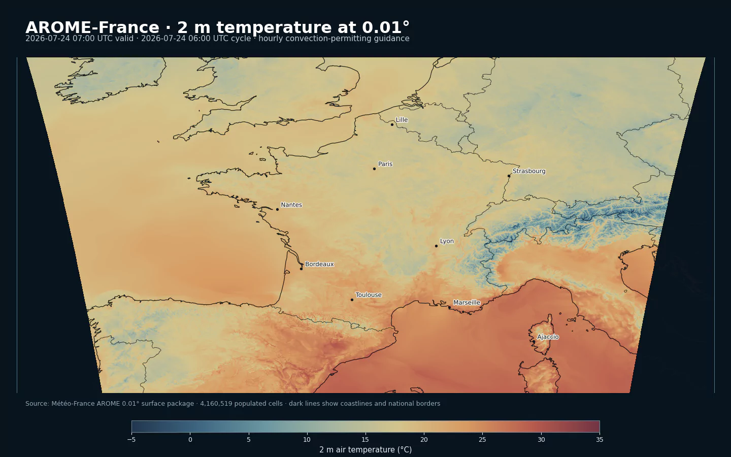
GribStream now supports Météo-France AROME 0.01°: convection-permitting forecasts for France and nearby countries, refreshed every three hours with hourly surface fields through 51 hours.
GribStream now supports Météo-France AROME 0.01° as aromefrance: convection-permitting deterministic guidance for metropolitan France and nearby countries, refreshed every three hours with hourly lead times through 51 hours.
AROME is Météo-France's short-range limited-area forecasting system. Its approximately 1.3 km model mesh is built to represent fine-scale terrain, precipitation, wind, clouds, and deep convection that broader European and global models necessarily smooth.
The first GribStream release focuses on 17 surface and near-surface fields from all eight daily cycles. It pairs familiar weather variables with high-value convective diagnostics, including maximum simulated radar reflectivity factor, surface-based CAPE, accumulated precipitation by hydrometeor type, and synthetic 10.8 µm brightness temperature.
A Convection-Permitting Forecast For France
Météo-France describes AROME as its 1.3 km model for mainland France and Corsica, providing forecasters with a much more detailed view of small-scale weather from the next few hours to the next few days.
That resolution places AROME in the convection-permitting class. It represents major cumulonimbus clouds and fine terrain effects more directly than models whose grid cells span many kilometers. This matters for localized thunderstorms, Alpine and Pyrenean flow, Mediterranean precipitation, coastal winds, fog, and narrow rain or snow bands.
The public dataset and the atmospheric model use related but distinct grids:
| Property | AROME-France system | aromefrance public product |
|---|---|---|
| Horizontal spacing | Approximately 1.3 km model mesh | Regular 0.01° latitude-longitude output |
| Vertical structure | 90 model levels | 17 surface and near-surface fields |
| Domain | Metropolitan France and neighboring countries | EURW1S100 envelope: 37.5N-55.4N, 12W-16E |
| Forecast range | Short range | Hourly from +0 through +51 hours |
The 0.01° label therefore describes the published output grid, not a claim that the atmospheric model itself runs on a uniform 0.01° mesh.
Current AROME Science: 3DEnVar, ALADIN, And Méso-NH
AROME has been operational at Météo-France since 2008. The Météo-France forecast-system overview describes a model assembled through French and international collaboration: its dynamics adapt the ALADIN core to fine scales, while much of its physical parameterization comes from the Méso-NH research model.
The initialization system changed substantially in October 2024. AROME-France now uses operational 3DEnVar data assimilation, replacing the 3D-Var scheme used since 2008. The ACCORD description of the change explains that 3DEnVar uses flow-dependent, ensemble-based background-error covariances. In practical terms, the way an observation influences surrounding model points can adapt to the current weather situation instead of relying on static and horizontally uniform covariances.
A more responsive analysis can improve the starting point, but it does not make an individual deterministic forecast certain. High resolution can sharpen a thunderstorm or precipitation band while still placing it too early, too late, or a few kilometers away.
Eight Forecasts Per Day Through 51 Hours
AROME-France runs every three hours. Unlike systems that reserve their longest horizon for a subset of cycles, the current 0.01° package guide specifies the same hourly 0-51 schedule throughout the day.
| Source cycles | Lead times | Update interval | Main role |
|---|---|---|---|
| 00, 03, 06, 09, 12, 15, 18, 21 UTC | +0 through +51 hours | Hourly | Fresh short-range regional guidance |
This cadence is especially useful when forecast freshness matters. A product can move to a new AROME cycle every three hours without losing the two-day forecast window, while the five-day GribStream archive keeps recent cycles available for comparison, verification, and short backtests.
Surface Weather And Convective Diagnostics
The initial aromefrance inventory contains 17 Météo-France parameter names:
| Group | Source fields | What they describe |
|---|---|---|
| Near-surface state | T, HU, U, V, P |
2 m temperature and humidity, 10 m wind components, and surface pressure |
| Wind extremes | U_RAF, V_RAF |
Maximum 10 m gust components over the preceding forecast hour |
| Clouds | NEBBAS, NEBMOY, NEBHAU |
Low, middle, and high cloud cover |
| Precipitation type | EAU, NEIGE, GRAUPEL |
Rain, snow, and graupel water equivalent accumulated since analysis time |
| Convection | CAPE_INS, RFLCTVT_MAX |
Surface-based CAPE and maximum simulated radar reflectivity factor |
| Observation-like diagnostics | BT |
Synthetic brightness temperature for the 10.8 µm infrared channel |
| Surface geometry | ALTITUDE |
Model terrain altitude, available at lead zero |
Forecast-hour precipitation selectors use info = "acc" because each field accumulates from the analysis time. EAU at +6 hours is therefore the total modeled liquid precipitation from hour 0 through hour 6, not an independent fifth-to-sixth-hour amount. Gust components use info = "max" and describe the preceding forecast hour.
RFLCTVT_MAX and BT deserve another distinction. They are diagnostics calculated from the model state so it can be compared with radar-like and satellite-like views. They are not radar measurements or satellite observations. Météo-France publishes RFLCTVT_MAX as a linear reflectivity factor in mm^6/m^3; it is not the separate dBZ reflectivity product.
Where AROME Adds Value
AROME's strongest role is the detailed short range over France:
- precipitation timing and type for catchments, roads, railways, and mountain operations
- convective context for outdoor events, aviation, logistics, and weather monitoring
- localized wind and gust guidance for renewable generation, cranes, ports, and exposed infrastructure
- temperature, humidity, pressure, and cloud inputs for energy demand, agriculture, and environmental models
- model-to-observation comparison using simulated reflectivity and infrared brightness temperature
It should sit inside a model hierarchy rather than replace every other source:
- use
aromefrancefor high-resolution deterministic guidance over France through 51 hours - use DWD ICON-EU for broader European coverage through five days
- use ICON-2I for 2.2 km regional guidance centered on Italy
- use DMI HARMONIE DINI for 2 km surface guidance over Northwestern Europe
- use ECMWF IFS for global context and a longer deterministic range
For decisions sensitive to thunderstorm location, peak gusts, or intense rainfall, add ensemble guidance and current observations. AROME provides one physically consistent high-resolution scenario, not a probability distribution.
Access AROME In GribStream
Use the dataset code aromefrance. The AROME France model page lists every available name, level, and info combination, including each selector's lead-time coverage. Refer to the API documentation for the current request syntax and endpoints.
Open Data With Attribution
Météo-France publishes the AROME 0.01° package under France's Open Licence 2.0. The licence permits free commercial and non-commercial reuse, adaptation, and redistribution, subject to source attribution and the licence's integrity requirements.
GribStream identifies Météo-France as the creator and links back to the official dataset. Applications that republish or redistribute derived AROME information should preserve that attribution.
Start Here
- Météo-France AROME model page and parameter inventory
- DWD ICON-EU model page
- ItaliaMeteo ICON-2I model page
- DMI HARMONIE DINI model page
- ECMWF IFS model page
- API documentation
Sources
- Météo-France AROME 0.01° package and Open Licence 2.0 metadata: https://www.data.gouv.fr/datasets/paquets-arome-resolution-0-01deg/
- Météo-France technical guide to the current AROME 0.01° packages: https://www.data.gouv.fr/api/1/datasets/r/3aa3ce62-1f69-4ea1-8157-a53eac61c6bb
- Météo-France overview of weather forecast models: https://meteofrance.com/actualites-et-dossiers/comprendre-la-meteo/les-modeles-de-prevision-meteo
- Météo-France overview of the ARPEGE and AROME forecast systems: https://donneespubliques.meteofrance.fr/client/document/presentation_modeles_arome-arpege-v2_244.pdf
- ACCORD/Météo-France description of operational 3DEnVar in AROME-France: https://www.umr-cnrm.fr/accord/IMG/pdf/accord_nl6.pdf
- Météo-France ARPEGE/AROME parameter glossary: https://donneespubliques.meteofrance.fr/client/document/description_parametres_modeles-arpege-arome-v2_184.pdf
- Open Licence 2.0: https://www.etalab.gouv.fr/licence-ouverte-open-licence/