ECMWF IFS ENS 0.1° 気象アンサンブル

GribStreamコード: ifsenfo0p1

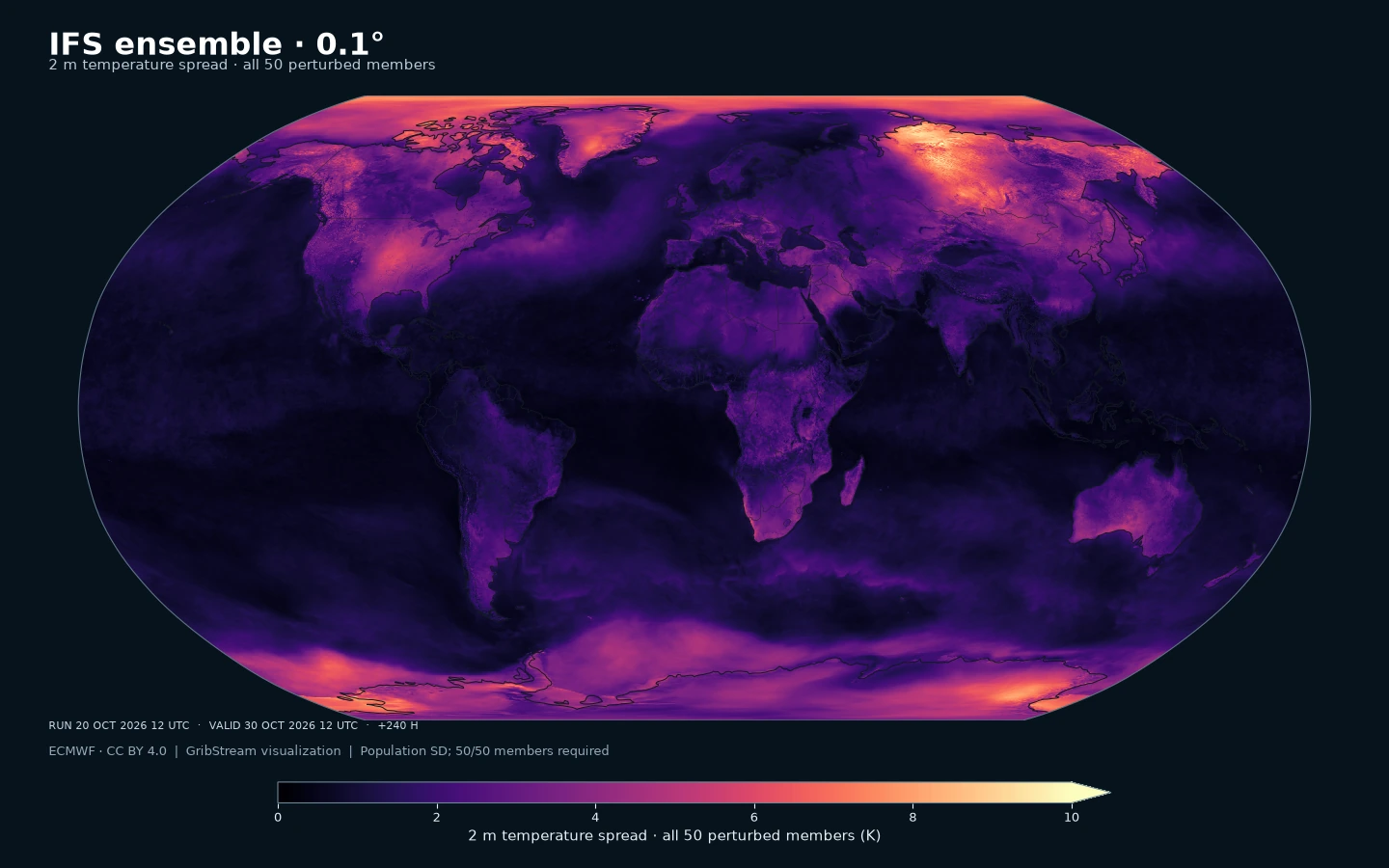
ECMWF IFS ENS 0.1° 気象アンサンブル: 2 m気温のばらつき(K)。GribStreamが摂動メンバー50個すべての母標準偏差を計算し、各格子点で50個の有効値を必要とします。
ifsenfo0p1 · 2 m気温のばらつき(K)。GribStreamが摂動メンバー50個すべての母標準偏差を計算し、各格子点で50個の有効値を必要とします。 保存済み予報の例:2026年10月20日12 UTC初期値、10月30日12 UTC有効(+240時間)。0.1°出力格子の最近傍セルで描画。データ:ECMWF、CC BY 4.0。可視化:GribStream。

この予報について

0.1°のECMWF IFSアンサンブル50メンバー。地表・土壌・上空の変数から、最大15日先の気象シナリオと不確実性を評価できます。

ECMWF IFSとは

IFSはIntegrated Forecasting System(統合予報システム)の略です。欧州中期予報センター(ECMWF)がMétéo-Franceと協力して開発し、データ同化によって観測を取り込み、物理方程式で地球システムの時間変化を計算します。大気・陸面・海洋・波浪の各要素が情報を交換します。これらは最大15日先までの短期・中期予報製品です。ECMWFは機械学習を用いる別系統のAIFSも開発しています。 ECMWF公式資料.

この製品の用途

ENSはECMWFのアンサンブル予報です。初期状態の小さな違いとモデル物理の不確実性を各メンバーで表現します。このデータセットはメンバー1~50を収録し、コントロールは決定論データセットに分かれています。各メンバーの時系列から、用途に合わせた百分位数、現象の確率、影響シナリオを計算できます。 ECMWF公式資料.

詳細

00・12 UTC:+0~144時間は3時間間隔、+150~360時間は6時間間隔(15日先まで)。06・18 UTC:+0~144時間は3時間間隔(6日先まで)。サイクルは初期時刻を示し、配信はその後です。

関連データセット

気象パラメータ

0 パラメータ

パラメータをクリックすると、コピーしやすいJSONセレクタ付きのコンパクトな表で候補を確認できます。コード、level、selector値はAPIが公開する値をそのまま保持します。

100u –100 metre U wind component (m s-1)
1 variant

Parameter ID 228246

ECMWF param DB

Eastward component of the 100 m wind, describing near-surface flow aloft.

  • Comparisons to observations require care because observations represent point measurements rather than grid-box means.
  • Combine with the 100 m V component to derive wind speed and direction.
Level Info Horizon Selector
sfc 0h-360h
{"name":"100u","level":"sfc","info":""}
100v –100 metre V wind component (m s-1)
1 variant

Parameter ID 228247

ECMWF param DB

Northward component of the 100 m wind, describing near-surface flow aloft.

  • Comparisons to observations require care because observations represent point measurements rather than grid-box means.
  • Combine with the 100 m U component to derive wind speed and direction.
Level Info Horizon Selector
sfc 0h-360h
{"name":"100v","level":"sfc","info":""}
10fg –Maximum 10 metre wind gust since previous post-processing (m s-1)
1 variant

Parameter ID 49

ECMWF param DB

Maximum 3‑second wind gust at 10 m height since the last post-processing step.

  • Convection effects are included after 2008-10-01; before that, only turbulence is represented.
  • Gusts are evaluated each time step and the maximum retained since the last post-processing.
Level Info Horizon Selector
sfc 0h-360h
{"name":"10fg","level":"sfc","info":""}
10fg3 –Maximum 10 metre wind gust in the last 3 hours (m s-1)
1 variant

Parameter ID 228028

ECMWF param DB

Maximum 3‑second wind gust at 10 m height over the previous 3 hours.

  • ECMWF estimates gusts within each time step using surface stress, friction, wind shear, and stability, then selects the maximum over the 3‑hour window.
  • Comparisons to observations require care because observations are point measurements.
Level Info Horizon Selector
sfc 93h-144h
{"name":"10fg3","level":"sfc","info":""}
10u –10 metre U wind component (m s-1)
1 variant

Parameter ID 165

ECMWF param DB

Eastward (U) component of near-surface wind.

  • Combine with the 10 m V component to derive wind speed and direction.
  • Observations can diverge due to terrain, vegetation, and local exposure.
Level Info Horizon Selector
sfc 0h-360h
{"name":"10u","level":"sfc","info":""}
10v –10 metre V wind component (m s-1)
1 variant

Parameter ID 166

ECMWF param DB

Northward (V) component of near-surface wind.

  • Combine with the 10 m U component to derive wind speed and direction.
  • Observations can diverge due to terrain, vegetation, and local exposure.
Level Info Horizon Selector
sfc 0h-360h
{"name":"10v","level":"sfc","info":""}
2d –2 metre dewpoint temperature (K)
1 variant

Parameter ID 168

ECMWF param DB

Dewpoint temperature describing near-surface moisture conditions. Useful for humidity diagnostics.

  • Often combined with temperature and pressure to estimate relative humidity.
  • Computed by interpolating between the lowest model level and the surface.
Level Info Horizon Selector
sfc 0h-360h
{"name":"2d","level":"sfc","info":""}
2t –2 metre temperature (K)
1 variant

Parameter ID 167

ECMWF param DB

Near-surface air temperature representative of conditions over land, sea, or inland waters. Derived using surface and lowest model level information.

  • Units are kelvin (K); to convert to degrees Celsius (deg C), subtract 273.15.
  • Mean 2 metre temperature is encoded separately (parameter 228004).
Level Info Horizon Selector
sfc 0h-360h
{"name":"2t","level":"sfc","info":""}
asn –Snow albedo ((0 - 1))
1 variant

Parameter ID 32

ECMWF param DB

Fraction of incoming shortwave radiation reflected by the snow-covered part of a grid box.

  • IFS represents snow as a single layer above the uppermost soil level.
  • Albedo varies with snow age and vegetation; typical ranges span 0.52–0.88 for low vegetation and 0.27–0.38 for high vegetation with snow underneath.
  • See parameter 228032 for the equivalent value expressed in percent.
Level Info Horizon Selector
sfc 0h-360h
{"name":"asn","level":"sfc","info":""}
cp –Convective precipitation (m)
1 variant

Parameter ID 143

ECMWF param DB

Accumulated precipitation from the convection scheme (rain + snow).

  • Does not include fog, dew, or precipitation that evaporates before reaching the surface.
  • Accumulated over the extraction period; depth in metres of water equivalent.
  • See parameter 228143 for the equivalent value expressed in kg m-2.
Level Info Horizon Selector
sfc 0h-360h
{"name":"cp","level":"sfc","info":""}
d –Divergence (s-1)
14 variants

Parameter ID 155

ECMWF param DB

Horizontal divergence of velocity, indicating spreading or convergence of airflow.

  • Positive values indicate divergence (air spreading out); negative values indicate convergence.
Level Info Horizon Selector
pl 10 0h-360h
{"name":"d","level":"pl 10","info":""}
pl 100 0h-360h
{"name":"d","level":"pl 100","info":""}
pl 1000 0h-360h
{"name":"d","level":"pl 1000","info":""}
pl 150 0h-360h
{"name":"d","level":"pl 150","info":""}
pl 200 0h-360h
{"name":"d","level":"pl 200","info":""}
pl 250 0h-360h
{"name":"d","level":"pl 250","info":""}
pl 300 0h-360h
{"name":"d","level":"pl 300","info":""}
pl 400 0h-360h
{"name":"d","level":"pl 400","info":""}
pl 50 0h-360h
{"name":"d","level":"pl 50","info":""}
pl 500 0h-360h
{"name":"d","level":"pl 500","info":""}
pl 600 0h-360h
{"name":"d","level":"pl 600","info":""}
pl 700 0h-360h
{"name":"d","level":"pl 700","info":""}
pl 850 0h-360h
{"name":"d","level":"pl 850","info":""}
pl 925 0h-360h
{"name":"d","level":"pl 925","info":""}
ewss –Time-integrated eastward turbulent surface stress (N m-2 s)
1 variant

Parameter ID 180

ECMWF param DB

Accumulated eastward surface stress from turbulent atmosphere–surface interactions and sub‑5 km orographic form drag.

  • Positive values denote stress toward the east; negative values denote westward stress.
  • Accumulated over the integration period of the extracted data.
Level Info Horizon Selector
sfc 0h-360h
{"name":"ewss","level":"sfc","info":""}
gh –Geopotential height (gpm)
14 variants

Parameter ID 156

ECMWF param DB

Height derived from geopotential divided by standard gravity (9.80665 m s-2).

  • Used on constant pressure levels to diagnose synoptic features (e.g., troughs, ridges, cyclones).
  • At the surface, it reflects orography (geopotential height of the surface).
  • A geopotential metre is approximately 2% shorter than a geometric metre.
Level Info Horizon Selector
pl 10 0h-360h
{"name":"gh","level":"pl 10","info":""}
pl 100 0h-360h
{"name":"gh","level":"pl 100","info":""}
pl 1000 0h-360h
{"name":"gh","level":"pl 1000","info":""}
pl 150 0h-360h
{"name":"gh","level":"pl 150","info":""}
pl 200 0h-360h
{"name":"gh","level":"pl 200","info":""}
pl 250 0h-360h
{"name":"gh","level":"pl 250","info":""}
pl 300 0h-360h
{"name":"gh","level":"pl 300","info":""}
pl 400 0h-360h
{"name":"gh","level":"pl 400","info":""}
pl 50 0h-360h
{"name":"gh","level":"pl 50","info":""}
pl 500 0h-360h
{"name":"gh","level":"pl 500","info":""}
pl 600 0h-360h
{"name":"gh","level":"pl 600","info":""}
pl 700 0h-360h
{"name":"gh","level":"pl 700","info":""}
pl 850 0h-360h
{"name":"gh","level":"pl 850","info":""}
pl 925 0h-360h
{"name":"gh","level":"pl 925","info":""}
hcc –High cloud cover ((0 - 1))
1 variant

Parameter ID 188

ECMWF param DB

Fraction of a grid box covered by high-level cloud.

  • Computed from model levels with pressure < 0.45 of surface pressure (~6 km and above).
  • Cloud fractions range from 0 to 1; overlap assumptions are applied across levels.
  • See parameter 3075 for the equivalent value in percent.
Level Info Horizon Selector
sfc 0h-360h
{"name":"hcc","level":"sfc","info":""}
lcc –Low cloud cover ((0 - 1))
1 variant

Parameter ID 186

ECMWF param DB

Fraction of a grid box covered by low-level cloud.

  • Computed from model levels with pressure > 0.8 of surface pressure (~2 km and below).
  • Cloud fractions range from 0 to 1; overlap assumptions are applied across levels.
  • See parameter 3073 for the equivalent value in percent.
Level Info Horizon Selector
sfc 0h-360h
{"name":"lcc","level":"sfc","info":""}
lsm –Land-sea mask ((0 - 1))
1 variant

Parameter ID 172

ECMWF param DB

Fraction of land within a grid box relative to ocean and inland waters.

  • Values range from 0 to 1 and are dimensionless.
  • From IFS CY41R1 (May 2015), grid boxes >0.5 may mix land and inland water; <=0.5 are water only.
  • Before CY41R1, >0.5 implied land only; <=0.5 implied ocean only (no inland water differentiation).
Level Info Horizon Selector
sfc 0h-360h
{"name":"lsm","level":"sfc","info":""}
mcc –Medium cloud cover ((0 - 1))
1 variant

Parameter ID 187

ECMWF param DB

Fraction of a grid box covered by medium-level cloud.

  • Computed from model levels between the low- and high-cloud pressure thresholds.
  • Cloud fractions range from 0 to 1; overlap assumptions are applied across levels.
  • See parameter 3074 for the equivalent value in percent.
Level Info Horizon Selector
sfc 0h-360h
{"name":"mcc","level":"sfc","info":""}
mn2t3 –Minimum temperature at 2 metres in the last 3 hours (K)
1 variant

Parameter ID 228027

ECMWF param DB

Lowest 2 m temperature observed over the previous 3 hours.

  • 2 m temperature is derived by interpolating between the lowest model level and the surface.
  • Units are kelvin (K); to convert to degrees Celsius (deg C), subtract 273.15.
  • Completed three-hour temperature extrema start at +3h. Anomalous +0h source records are excluded: the audited launch cycles contain 0 K placeholders with contradictory interval metadata. Timeseries can select a prior run's completed interval when eligible under asOf and lead bounds; otherwise it remains missing. Completed intervals and initialization exclusions
Level Info Horizon Selector
sfc 3h-144h
{"name":"mn2t3","level":"sfc","info":""}
mn2t6 –Minimum temperature at 2 metres in the last 6 hours (K)
1 variant

Parameter ID 122

ECMWF param DB

Lowest 2 m temperature observed over the previous 6 hours.

  • 2 m temperature is derived by interpolating between the lowest model level and the surface.
  • Units are kelvin (K); to convert to degrees Celsius (deg C), subtract 273.15.
Level Info Horizon Selector
sfc 150h-360h
{"name":"mn2t6","level":"sfc","info":""}
msl –Mean sea level pressure (Pa)
1 variant

Parameter ID 151

ECMWF param DB

Atmospheric pressure adjusted to mean sea level, reflecting the weight of the air column.

  • Maps of mean sea level pressure highlight cyclones, anticyclones, and wind strength via contour spacing.
  • Often expressed in hPa or millibars (1 hPa = 1 mb = 100 Pa).
Level Info Horizon Selector
sfc 0h-360h
{"name":"msl","level":"sfc","info":""}
mucape –Most-unstable CAPE (J kg-1)
1 variant

Parameter ID 228235

ECMWF param DB

Convective Available Potential Energy for the most unstable parcel in the layer from the surface to 350 hPa.

  • Relates to maximum potential updraft velocity.
  • In the lowest 60 hPa, 30‑hPa mixed‑layer parameters are used.
Level Info Horizon Selector
sfc 0h-360h
{"name":"mucape","level":"sfc","info":""}
mx2t3 –Maximum temperature at 2 metres in the last 3 hours (K)
1 variant

Parameter ID 228026

ECMWF param DB

Highest 2 m temperature observed over the previous 3 hours.

  • 2 m temperature is derived by interpolating between the lowest model level and the surface.
  • Units are kelvin (K); to convert to degrees Celsius (deg C), subtract 273.15.
  • Completed three-hour temperature extrema start at +3h. Anomalous +0h source records are excluded: the audited launch cycles contain 0 K placeholders with contradictory interval metadata. Timeseries can select a prior run's completed interval when eligible under asOf and lead bounds; otherwise it remains missing. Completed intervals and initialization exclusions
Level Info Horizon Selector
sfc 3h-144h
{"name":"mx2t3","level":"sfc","info":""}
mx2t6 –Maximum temperature at 2 metres in the last 6 hours (K)
1 variant

Parameter ID 121

ECMWF param DB

Highest 2 m temperature observed over the previous 6 hours.

  • 2 m temperature is derived by interpolating between the lowest model level and the surface.
  • Units are kelvin (K); to convert to degrees Celsius (deg C), subtract 273.15.
Level Info Horizon Selector
sfc 150h-360h
{"name":"mx2t6","level":"sfc","info":""}
nsss –Time-integrated northward turbulent surface stress (N m-2 s)
1 variant

Parameter ID 181

ECMWF param DB

Accumulated northward surface stress from turbulent atmosphere–surface interactions and sub‑5 km orographic form drag.

  • Positive values denote stress toward the north; negative values denote southward stress.
  • Accumulated over the integration period of the extracted data.
Level Info Horizon Selector
sfc 0h-360h
{"name":"nsss","level":"sfc","info":""}
ptype –Precipitation type (Code table 4.201)
1 variant

Parameter ID 260015

ECMWF param DB

Surface precipitation type derived from predicted rain and snow fields plus atmospheric conditions.

  • Use alongside precipitation rate to flag events such as freezing rain.
  • IFS codes: 0 none, 1 rain, 3 freezing rain, 5 snow, 6 wet snow, 7 rain/snow mix, 8 ice pellets, 12 freezing drizzle.
  • IFS does not diagnose WMO codes 2, 4, 9, 10, 11.
Level Info Horizon Selector
sfc 0h-360h
{"name":"ptype","level":"sfc","info":""}
q –Specific humidity (kg kg-1)
14 variants

Parameter ID 133

ECMWF param DB

Mass of water vapour per kilogram of moist air.

  • Moist air includes dry air, water vapour, cloud liquid, cloud ice, rain, and falling snow.
Level Info Horizon Selector
pl 10 0h-360h
{"name":"q","level":"pl 10","info":""}
pl 100 0h-360h
{"name":"q","level":"pl 100","info":""}
pl 1000 0h-360h
{"name":"q","level":"pl 1000","info":""}
pl 150 0h-360h
{"name":"q","level":"pl 150","info":""}
pl 200 0h-360h
{"name":"q","level":"pl 200","info":""}
pl 250 0h-360h
{"name":"q","level":"pl 250","info":""}
pl 300 0h-360h
{"name":"q","level":"pl 300","info":""}
pl 400 0h-360h
{"name":"q","level":"pl 400","info":""}
pl 50 0h-360h
{"name":"q","level":"pl 50","info":""}
pl 500 0h-360h
{"name":"q","level":"pl 500","info":""}
pl 600 0h-360h
{"name":"q","level":"pl 600","info":""}
pl 700 0h-360h
{"name":"q","level":"pl 700","info":""}
pl 850 0h-360h
{"name":"q","level":"pl 850","info":""}
pl 925 0h-360h
{"name":"q","level":"pl 925","info":""}
r –Relative humidity (%)
14 variants

Parameter ID 157

ECMWF param DB

Water vapour pressure as a percentage of saturation.

  • For temperatures >0°C, saturation is over water; below -23°C, over ice.
  • Between -23°C and 0°C, values are interpolated between ice and water using a quadratic function.
Level Info Horizon Selector
pl 10 0h-360h
{"name":"r","level":"pl 10","info":""}
pl 100 0h-360h
{"name":"r","level":"pl 100","info":""}
pl 1000 0h-360h
{"name":"r","level":"pl 1000","info":""}
pl 150 0h-360h
{"name":"r","level":"pl 150","info":""}
pl 200 0h-360h
{"name":"r","level":"pl 200","info":""}
pl 250 0h-360h
{"name":"r","level":"pl 250","info":""}
pl 300 0h-360h
{"name":"r","level":"pl 300","info":""}
pl 400 0h-360h
{"name":"r","level":"pl 400","info":""}
pl 50 0h-360h
{"name":"r","level":"pl 50","info":""}
pl 500 0h-360h
{"name":"r","level":"pl 500","info":""}
pl 600 0h-360h
{"name":"r","level":"pl 600","info":""}
pl 700 0h-360h
{"name":"r","level":"pl 700","info":""}
pl 850 0h-360h
{"name":"r","level":"pl 850","info":""}
pl 925 0h-360h
{"name":"r","level":"pl 925","info":""}
ro –Runoff (m)
1 variant

Parameter ID 205

ECMWF param DB

Total surface + subsurface runoff accumulated over the output period, expressed as equivalent water depth.

  • Useful as a drought or flood indicator; comparisons to observations require care due to scale and unit differences.
  • See parameter 231002 for the equivalent value expressed in kg m-2.
Level Info Horizon Selector
sfc 0h-360h
{"name":"ro","level":"sfc","info":""}
rsn –Snow density (kg m-3)
1 variant

Parameter ID 33

ECMWF param DB

Mass of snow per cubic metre in the model snow layer.

  • The IFS represents snow as a layer over the uppermost soil level, with snow covering all or part of a grid box.
Level Info Horizon Selector
sfc 0h-360h
{"name":"rsn","level":"sfc","info":""}
sd –Snow depth (m of water equivalent)
1 variant

Parameter ID 141

ECMWF param DB

Depth of snow expressed as the equivalent depth of water if the snow melted.

  • Represents snow over the snow-covered part of the grid box.
  • See parameter 228141 for the equivalent value expressed in kg m-2.
Level Info Horizon Selector
sfc 0h-360h
{"name":"sd","level":"sfc","info":""}
sf –Snowfall (m of water equivalent)
1 variant

Parameter ID 144

ECMWF param DB

Accumulated snowfall at the surface (large-scale + convective).

  • Accumulated over the extraction period; depth in metres of water equivalent.
  • See parameter 228144 for the equivalent value expressed in kg m-2.
Level Info Horizon Selector
sfc 0h-360h
{"name":"sf","level":"sfc","info":""}
sithick –Sea-ice thickness (m)
1 variant

Parameter ID 174098

ECMWF param DB

Thickness of sea ice within a grid box.

Level Info Horizon Selector
sfc 0h-360h
{"name":"sithick","level":"sfc","info":""}
skt –Skin temperature (K)
1 variant

Parameter ID 235

ECMWF param DB

Temperature of the Earth's surface required to satisfy the surface energy balance.

  • Represents the uppermost surface layer with no heat capacity, so it responds instantly to surface flux changes.
  • Computed differently over land and sea.
  • Units are kelvin (K); to convert to degrees Celsius (deg C), subtract 273.15.
  • Mean skin temperature is encoded separately (parameter 235079).
Level Info Horizon Selector
sfc 0h-360h
{"name":"skt","level":"sfc","info":""}
sot –Soil temperature (K)
4 variants

Parameter ID 260360

ECMWF param DB

Soil temperature.

  • The launch-day source inventory contains soil layers in the 12 UTC run, but not the 06 UTC run. Check run availability when querying these selectors.
Level Info Horizon Selector
sol 1 0h-360h
{"name":"sot","level":"sol 1","info":""}
sol 2 0h-360h
{"name":"sot","level":"sol 2","info":""}
sol 3 0h-360h
{"name":"sot","level":"sol 3","info":""}
sol 4 0h-360h
{"name":"sot","level":"sol 4","info":""}
sp –Surface pressure (Pa)
1 variant

Parameter ID 134

ECMWF param DB

Atmospheric pressure at the surface of land, sea, and inland water.

  • Often used with temperature to estimate air density.
  • Mean sea level pressure is typically preferred for identifying large-scale pressure systems in mountainous regions.
  • Often expressed in hPa or millibars (1 hPa = 1 mb = 100 Pa).
Level Info Horizon Selector
sfc 0h-360h
{"name":"sp","level":"sfc","info":""}
ssr –Surface net short-wave (solar) radiation (J m-2)
1 variant

Parameter ID 176

ECMWF param DB

Net shortwave radiation at the surface (downward minus reflected).

  • Depends on surface albedo and atmospheric absorption/scattering.
  • Accumulated over the extraction period; divide by seconds to convert to W m-2.
  • ECMWF convention for vertical fluxes is positive downward.
Level Info Horizon Selector
sfc 0h-360h
{"name":"ssr","level":"sfc","info":""}
ssrd –Surface short-wave (solar) radiation downwards (J m-2)
1 variant

Parameter ID 169

ECMWF param DB

Downward shortwave radiation at the surface (direct + diffuse).

  • Approximate model equivalent of pyranometer measurements.
  • Accumulated over the extraction period; divide by seconds to convert to W m-2.
  • ECMWF convention for vertical fluxes is positive downward.
Level Info Horizon Selector
sfc 0h-360h
{"name":"ssrd","level":"sfc","info":""}
str –Surface net long-wave (thermal) radiation (J m-2)
1 variant

Parameter ID 177

ECMWF param DB

Net longwave radiation at the surface (downward minus upward).

  • Includes atmospheric and cloud emission to the surface and surface emission/reflectance upward.
  • Accumulated over the extraction period; divide by seconds to convert to W m-2.
  • ECMWF convention for vertical fluxes is positive downward.
Level Info Horizon Selector
sfc 0h-360h
{"name":"str","level":"sfc","info":""}
strd –Surface long-wave (thermal) radiation downwards (J m-2)
1 variant

Parameter ID 175

ECMWF param DB

Downward longwave radiation at the surface emitted by the atmosphere and clouds.

  • Accumulated over the extraction period; divide by seconds to convert to W m-2.
  • ECMWF convention for vertical fluxes is positive downward.
Level Info Horizon Selector
sfc 0h-360h
{"name":"strd","level":"sfc","info":""}
sve –Eastward surface sea water velocity (m s-1)
1 variant

Parameter ID 262140

ECMWF param DB

Eastward component of surface sea water velocity.

Level Info Horizon Selector
sfc 0h-360h
{"name":"sve","level":"sfc","info":""}
svn –Northward surface sea water velocity (m s-1)
1 variant

Parameter ID 262139

ECMWF param DB

Northward component of surface sea water velocity.

Level Info Horizon Selector
sfc 0h-360h
{"name":"svn","level":"sfc","info":""}
t –Temperature (K)
14 variants

Parameter ID 130

ECMWF param DB

Air temperature throughout the atmosphere.

  • Units are kelvin (K); to convert to degrees Celsius (deg C), subtract 273.15.
  • Available on multiple vertical levels.
Level Info Horizon Selector
pl 10 0h-360h
{"name":"t","level":"pl 10","info":""}
pl 100 0h-360h
{"name":"t","level":"pl 100","info":""}
pl 1000 0h-360h
{"name":"t","level":"pl 1000","info":""}
pl 150 0h-360h
{"name":"t","level":"pl 150","info":""}
pl 200 0h-360h
{"name":"t","level":"pl 200","info":""}
pl 250 0h-360h
{"name":"t","level":"pl 250","info":""}
pl 300 0h-360h
{"name":"t","level":"pl 300","info":""}
pl 400 0h-360h
{"name":"t","level":"pl 400","info":""}
pl 50 0h-360h
{"name":"t","level":"pl 50","info":""}
pl 500 0h-360h
{"name":"t","level":"pl 500","info":""}
pl 600 0h-360h
{"name":"t","level":"pl 600","info":""}
pl 700 0h-360h
{"name":"t","level":"pl 700","info":""}
pl 850 0h-360h
{"name":"t","level":"pl 850","info":""}
pl 925 0h-360h
{"name":"t","level":"pl 925","info":""}
tcc –Total cloud cover ((0 - 1))
1 variant

Parameter ID 164

ECMWF param DB

Fraction of a grid box covered by cloud across all model levels.

  • Computed from cloud across different heights with overlap assumptions.
  • See parameter 228164 for the equivalent value in percent.
Level Info Horizon Selector
sfc 0h-360h
{"name":"tcc","level":"sfc","info":""}
tciw –Total column cloud ice water (kg/m^2)
1 variant

Total column cloud ice water (kg/m^2).

Level Info Horizon Selector
sfc 0h-360h
{"name":"tciw","level":"sfc","info":""}
tclw –Total column cloud liquid water (kg/m^2)
1 variant

Total column cloud liquid water (kg/m^2).

Level Info Horizon Selector
sfc 0h-360h
{"name":"tclw","level":"sfc","info":""}
tcrw –Total column rain water (kg/m^2)
1 variant

Total column rain water (kg/m^2).

Level Info Horizon Selector
sfc 0h-360h
{"name":"tcrw","level":"sfc","info":""}
tcw –Total column water (kg m-2)
1 variant

Parameter ID 136

ECMWF param DB

Total column water including vapour, liquid water, cloud ice, rain, and snow.

  • Older IFS versions did not include rain and snow in the total.
Level Info Horizon Selector
sfc 0h-360h
{"name":"tcw","level":"sfc","info":""}
tcwv –Total column vertically-integrated water vapour (kg m-2)
1 variant

Parameter ID 137

ECMWF param DB

Total water vapour in a column from the surface to the top of the atmosphere.

  • Represents a grid-box mean value.
Level Info Horizon Selector
sfc 0h-360h
{"name":"tcwv","level":"sfc","info":""}
tp –Total precipitation (m)
1 variant

Parameter ID 228

ECMWF param DB

Accumulated rain + snow at the surface (large-scale + convective).

  • Does not include fog, dew, or precipitation that evaporates before reaching the surface.
  • Accumulated over the extraction period; depth in metres of water equivalent.
  • See parameter 228228 for the equivalent value expressed in kg m-2.
Level Info Horizon Selector
sfc 0h-360h
{"name":"tp","level":"sfc","info":""}
tprate –Time-mean total precipitation rate (m s-1)
1 variant

Parameter ID 172228

ECMWF param DB

Mean rate of total precipitation (accumulated precipitation divided by the accumulation period).

  • Total precipitation includes large-scale + convective rain and snow; excludes fog, dew, and precipitation that evaporates before reaching the surface.
  • Units represent depth of water equivalent per second.
  • Comparisons to observations require care due to spatial and temporal scale differences.
Level Info Horizon Selector
sfc 0h-360h
{"name":"tprate","level":"sfc","info":""}
ttr –Top net long-wave (thermal) radiation (J m-2)
1 variant

Parameter ID 179

ECMWF param DB

Net longwave radiation at the top of the atmosphere (negative of OLR).

  • Accumulated over the extraction period; divide by seconds to convert to W m-2.
  • ECMWF convention for vertical fluxes is positive downward.
Level Info Horizon Selector
sfc 0h-360h
{"name":"ttr","level":"sfc","info":""}
u –U component of wind (m s-1)
14 variants

Parameter ID 131

ECMWF param DB

Eastward wind component; negative values indicate westward flow.

  • Combine with the V component to derive wind speed and direction.
Level Info Horizon Selector
pl 10 0h-360h
{"name":"u","level":"pl 10","info":""}
pl 100 0h-360h
{"name":"u","level":"pl 100","info":""}
pl 1000 0h-360h
{"name":"u","level":"pl 1000","info":""}
pl 150 0h-360h
{"name":"u","level":"pl 150","info":""}
pl 200 0h-360h
{"name":"u","level":"pl 200","info":""}
pl 250 0h-360h
{"name":"u","level":"pl 250","info":""}
pl 300 0h-360h
{"name":"u","level":"pl 300","info":""}
pl 400 0h-360h
{"name":"u","level":"pl 400","info":""}
pl 50 0h-360h
{"name":"u","level":"pl 50","info":""}
pl 500 0h-360h
{"name":"u","level":"pl 500","info":""}
pl 600 0h-360h
{"name":"u","level":"pl 600","info":""}
pl 700 0h-360h
{"name":"u","level":"pl 700","info":""}
pl 850 0h-360h
{"name":"u","level":"pl 850","info":""}
pl 925 0h-360h
{"name":"u","level":"pl 925","info":""}
v –V component of wind (m s-1)
14 variants

Parameter ID 132

ECMWF param DB

Northward wind component; negative values indicate southward flow.

  • Combine with the U component to derive wind speed and direction.
Level Info Horizon Selector
pl 10 0h-360h
{"name":"v","level":"pl 10","info":""}
pl 100 0h-360h
{"name":"v","level":"pl 100","info":""}
pl 1000 0h-360h
{"name":"v","level":"pl 1000","info":""}
pl 150 0h-360h
{"name":"v","level":"pl 150","info":""}
pl 200 0h-360h
{"name":"v","level":"pl 200","info":""}
pl 250 0h-360h
{"name":"v","level":"pl 250","info":""}
pl 300 0h-360h
{"name":"v","level":"pl 300","info":""}
pl 400 0h-360h
{"name":"v","level":"pl 400","info":""}
pl 50 0h-360h
{"name":"v","level":"pl 50","info":""}
pl 500 0h-360h
{"name":"v","level":"pl 500","info":""}
pl 600 0h-360h
{"name":"v","level":"pl 600","info":""}
pl 700 0h-360h
{"name":"v","level":"pl 700","info":""}
pl 850 0h-360h
{"name":"v","level":"pl 850","info":""}
pl 925 0h-360h
{"name":"v","level":"pl 925","info":""}
vo –Vorticity (relative) (s-1)
14 variants

Parameter ID 138

ECMWF param DB

Rotation of horizontal flow about a vertical axis relative to the Earth’s surface.

  • Negative/positive values correspond to clockwise/anticlockwise rotation depending on hemisphere; adding the Coriolis parameter gives absolute vorticity.
Level Info Horizon Selector
pl 10 0h-360h
{"name":"vo","level":"pl 10","info":""}
pl 100 0h-360h
{"name":"vo","level":"pl 100","info":""}
pl 1000 0h-360h
{"name":"vo","level":"pl 1000","info":""}
pl 150 0h-360h
{"name":"vo","level":"pl 150","info":""}
pl 200 0h-360h
{"name":"vo","level":"pl 200","info":""}
pl 250 0h-360h
{"name":"vo","level":"pl 250","info":""}
pl 300 0h-360h
{"name":"vo","level":"pl 300","info":""}
pl 400 0h-360h
{"name":"vo","level":"pl 400","info":""}
pl 50 0h-360h
{"name":"vo","level":"pl 50","info":""}
pl 500 0h-360h
{"name":"vo","level":"pl 500","info":""}
pl 600 0h-360h
{"name":"vo","level":"pl 600","info":""}
pl 700 0h-360h
{"name":"vo","level":"pl 700","info":""}
pl 850 0h-360h
{"name":"vo","level":"pl 850","info":""}
pl 925 0h-360h
{"name":"vo","level":"pl 925","info":""}
vsw –Volumetric soil moisture (m3 m-3)
4 variants

Parameter ID 260199

ECMWF param DB

Volumetric soil moisture content.

  • Time-mean volumetric soil moisture is encoded separately (parameter 235077).
  • The launch-day source inventory contains soil layers in the 12 UTC run, but not the 06 UTC run. Check run availability when querying these selectors.
Level Info Horizon Selector
sol 1 0h-360h
{"name":"vsw","level":"sol 1","info":""}
sol 2 0h-360h
{"name":"vsw","level":"sol 2","info":""}
sol 3 0h-360h
{"name":"vsw","level":"sol 3","info":""}
sol 4 0h-360h
{"name":"vsw","level":"sol 4","info":""}
w –Vertical velocity (Pa s-1)
14 variants

Parameter ID 135

ECMWF param DB

Vertical motion in pressure coordinates; negative values indicate upward motion.

  • Useful for diagnosing large-scale ascent (negative) and subsidence (positive).
Level Info Horizon Selector
pl 10 0h-360h
{"name":"w","level":"pl 10","info":""}
pl 100 0h-360h
{"name":"w","level":"pl 100","info":""}
pl 1000 0h-360h
{"name":"w","level":"pl 1000","info":""}
pl 150 0h-360h
{"name":"w","level":"pl 150","info":""}
pl 200 0h-360h
{"name":"w","level":"pl 200","info":""}
pl 250 0h-360h
{"name":"w","level":"pl 250","info":""}
pl 300 0h-360h
{"name":"w","level":"pl 300","info":""}
pl 400 0h-360h
{"name":"w","level":"pl 400","info":""}
pl 50 0h-360h
{"name":"w","level":"pl 50","info":""}
pl 500 0h-360h
{"name":"w","level":"pl 500","info":""}
pl 600 0h-360h
{"name":"w","level":"pl 600","info":""}
pl 700 0h-360h
{"name":"w","level":"pl 700","info":""}
pl 850 0h-360h
{"name":"w","level":"pl 850","info":""}
pl 925 0h-360h
{"name":"w","level":"pl 925","info":""}
zos –Sea surface height (m)
1 variant
Level Info Horizon Selector
sfc 0h-360h
{"name":"zos","level":"sfc","info":""}

検索に一致するパラメータはありません。