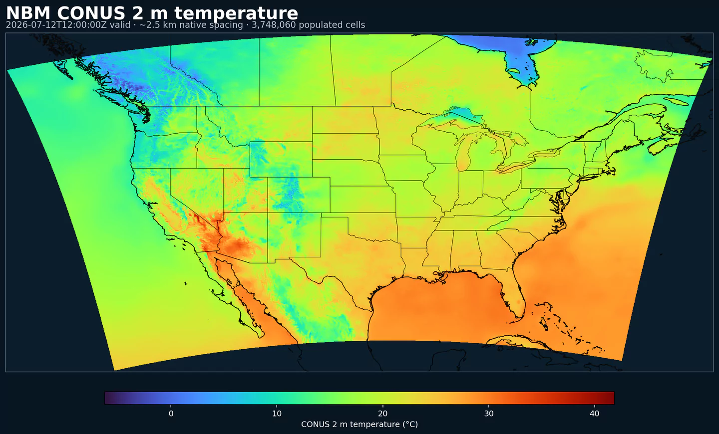
NBM 2 m temperature across the complete populated approximately 2.5 km CONUS product grid shared by these NBM products, with black boundaries. This coverage reference was generated from nbm for the nbmpar page; available variables may differ.
Accumulated precipitation represents the total water-equivalent amount of rain and snow during the output period. It is a primary field for hydrologic impacts and event totals.
Units: kg/m^2.
Use with the model time interval to interpret totals and compare to gauges.
Apparent temperature combines air temperature, humidity, and wind to estimate how hot or cold it feels to humans. It is useful for heat and cold stress assessments.
Units: K.
Level
Info
Horizon
Introduced
Selector
2 m above ground
1h-264h
5 days ago
{"name":"APTMP","level":"2 m above ground","info":""}
Convective Available Potential Energy (CAPE) quantifies buoyant energy available to rising air parcels. Larger values generally imply stronger potential updrafts and greater convective intensity.
Units: J/kg.
Often used with CIN and lifting mechanisms to assess thunderstorm potential.
Ceiling height is the altitude of the lowest cloud base that covers a significant portion of the sky. It is a key aviation and surface-visibility metric.
Craven-Wiedenfeld aggregate severe parameter combines instability and wind shear to indicate severe weather potential. Higher values suggest a higher risk of organized severe storms.
Distance to feature is the horizontal distance to the named hazard or boundary in the source product. It is used to map proximity to key features like fronts or hazards.
Units: km.
Level
Info
Horizon
Introduced
Selector
surface - 610 m above ground
1h-36h
5 days ago
{"name":"DIST","level":"surface - 610 m above ground","info":""}
Dry thunderstorm probability indicates the chance of thunderstorms with little or no rainfall. It is used for wildfire ignition risk and lightning without wetting rain.
Ellrod index is a diagnostic for clear-air turbulence based on deformation and vertical wind shear. Higher values indicate greater turbulence potential for aviation.
Fosberg fire weather index combines temperature, humidity, and wind to estimate potential fire spread. Higher values indicate more favorable wildfire conditions.
Joint fire weather probability expresses the chance that combined fire-weather criteria are met during the valid period. It is intended for elevated wildfire-spread and rapid-growth risk assessment.
Units: %.
Interpret this as a probability field rather than a categorical flag.
Level
Info
Horizon
Introduced
Selector
surface
1h-264h
5 days ago
{"name":"JFWPRB","level":"surface","info":""}
MAXREF–Hourly Maximum of Simulated Reflectivity at 1 km AGL (dBZ)
Hourly maximum simulated reflectivity at 1 km AGL captures the strongest modeled reflectivity near the surface. It is used to identify peak convective intensity and heavy precipitation cores.
Units: dBZ.
Level
Info
Horizon
Introduced
Selector
1000 m above ground
1h-48h
5 days ago
{"name":"MAXREF","level":"1000 m above ground","info":""}
Coded surface precipitation type derived from model precipitation and near-surface thermodynamics. It distinguishes rain, snow, freezing rain, mixed types, and related categories.
Units: coded.
Interpret together with precipitation rate or accumulation.
Predominant weather encodes the most likely weather type for the grid cell and valid period. It is used for compact categorical weather guidance such as rain, snow, ice, fog, or thunder-related outcomes.
Units: coded.
Code meanings depend on the model or product's weather-category mapping.
Wet bulb globe temperature combines temperature, humidity, radiation, and wind effects into a single heat-stress metric. It is commonly used for outdoor exposure and occupational heat-risk assessment.
Units: K.
Use it as a composite heat-stress indicator rather than a standard air-temperature field.