Apparent temperature combines air temperature, humidity, and wind to estimate how hot or cold it feels to humans. It is useful for heat and cold stress assessments.
- Units: K.
GribStreamコード: nbmparoc
他のNBM Parallel格子:
nbmpar, nbmparak, nbmparhi, nbmparpr, nbmpargu
ステータス: GribStreamではNBM v5がnbmocで運用版になっています。nbmocでは、2026-05-05 12:00 UTCより前のモデル実行は以前の運用NBM版を含み、2026-05-05 12:00 UTC以降のモデル実行はNBM v5を使います。NBM v5を本番運用に組み込む場合はnbmocを使ってください。nbmpar*データセットは、NOAAが将来並行比較ラインで実験的な検証版を再公開する場合の比較用として残します。
公開元のS3バケットはnoaa-nbm-para-pdsです。GribStreamは並行比較ラインを専用データセットコードで分け、運用NBMファミリーのアーカイブと混ぜずに比較できるようにしています。
技術リファレンス: PNS 25-45、Winter v5.0 configuration notes、NBM Versionsを参照してください。
NBM Parallel Oceanicは、Oceanic格子向けNational Blend of Modelsの公開比較用出力です。NOAAが運用版の横で実験的ラインを公開する場合、比較と検証に使います。
NBM v5を本番利用する場合、推奨データセットはnbmocです。nbmparocはバージョン変更の比較や、NOAAが将来公開する並行比較ラインの実験的な検証版のための場所として残します。
NBM v5は単なるパラメータ変更ではありません。NOAAは多くの1時間ごとの予報ガイダンスを36 hから48 hへ伸ばし、Quantile Mapping、決定論的な風・突風の変更、より高解像度のECMWF/Canadian入力を含むブレンドを見直しました。
Oceanic領域では、NBM v5の資料が、Quantile Mappingを使う確率的な風・突風ガイダンス、気温、露点、雲量プロダクトの更新、より広い入力モデルのブレンドとQuantile Mappingに移行した有義波高補正を示しています。
GribStreamでは、nbmparocのセレクタは安定しています。name、level、info値はカタログから正確にコピーし、翻訳しません。
nbmparocカタログの変数コード、level、info値を保持します。パラメータをクリックすると、コピーしやすいJSONセレクタ付きのコンパクトな表で候補を確認できます。コード、level、selector値はAPIが公開する値をそのまま保持します。
Apparent temperature combines air temperature, humidity, and wind to estimate how hot or cold it feels to humans. It is useful for heat and cold stress assessments.
| Level | Info | Horizon | Introduced | Selector |
|---|---|---|---|---|
2 m above ground |
2h-264h | 5 days ago |
{"name":"APTMP","level":"2 m above ground","info":""}
|
Dew point temperature is the temperature at which the air becomes saturated. It is a direct measure of moisture content.
| Level | Info | Horizon | Introduced | Selector |
|---|---|---|---|---|
2 m above ground |
50% level |
2h-264h | 5 days ago |
{"name":"DPT","level":"2 m above ground","info":"50% level"}
|
Freezing spray indicator flags marine conditions favorable for ice accretion on vessels. It depends on wind, air temperature, and wave conditions.
| Level | Info | Horizon | Introduced | Selector |
|---|---|---|---|---|
surface |
2h-264h | 5 days ago |
{"name":"FRZSPR","level":"surface","info":""}
|
Wind gust is the peak short-duration wind speed. It captures brief, hazardous bursts that can exceed sustained winds.
| Level | Info | Horizon | Introduced | Selector |
|---|---|---|---|---|
10 m above ground |
50% level |
2h-264h | 5 days ago |
{"name":"GUST","level":"10 m above ground","info":"50% level"}
|
Precipitable water is the total column water vapor from the surface to the top of the atmosphere. It is a key moisture indicator.
| Level | Info | Horizon | Introduced | Selector |
|---|---|---|---|---|
entire atmosphere (considered as a single layer) |
1h-264h | 5 days ago |
{"name":"PWAT","level":"entire atmosphere (considered as a single layer)","info":""}
|
|
entire atmosphere (considered as a single layer) |
10% level |
1h-264h | 5 days ago |
{"name":"PWAT","level":"entire atmosphere (considered as a single layer)","info":"10% level"}
|
entire atmosphere (considered as a single layer) |
50% level |
1h-264h | 5 days ago |
{"name":"PWAT","level":"entire atmosphere (considered as a single layer)","info":"50% level"}
|
entire atmosphere (considered as a single layer) |
90% level |
1h-264h | 5 days ago |
{"name":"PWAT","level":"entire atmosphere (considered as a single layer)","info":"90% level"}
|
entire atmosphere (considered as a single layer) |
prob >12.7 |
1h-264h | 5 days ago |
{"name":"PWAT","level":"entire atmosphere (considered as a single layer)","info":"prob >12.7"}
|
entire atmosphere (considered as a single layer) |
prob >25.4 |
1h-264h | 5 days ago |
{"name":"PWAT","level":"entire atmosphere (considered as a single layer)","info":"prob >25.4"}
|
entire atmosphere (considered as a single layer) |
prob >38.1 |
1h-264h | 5 days ago |
{"name":"PWAT","level":"entire atmosphere (considered as a single layer)","info":"prob >38.1"}
|
entire atmosphere (considered as a single layer) |
prob >50.8 |
1h-264h | 5 days ago |
{"name":"PWAT","level":"entire atmosphere (considered as a single layer)","info":"prob >50.8"}
|
entire atmosphere (considered as a single layer) |
prob >63.5 |
1h-264h | 5 days ago |
{"name":"PWAT","level":"entire atmosphere (considered as a single layer)","info":"prob >63.5"}
|
Total cloud cover is the fraction of the grid cell covered by clouds at any level. It influences radiation, temperature, and visibility.
| Level | Info | Horizon | Introduced | Selector |
|---|---|---|---|---|
surface |
2h-264h | 5 days ago |
{"name":"TCDC","level":"surface","info":""}
|
|
surface |
ens std dev |
2h-264h | 5 days ago |
{"name":"TCDC","level":"surface","info":"ens std dev"}
|
Thunderstorm probability gives the chance of thunderstorms during the valid period. It is used for convective hazard guidance.
| Level | Info | Horizon | Introduced | Selector |
|---|---|---|---|---|
entire atmosphere |
1h-36h | 5 days ago |
{"name":"THUNC","level":"entire atmosphere","info":""}
|
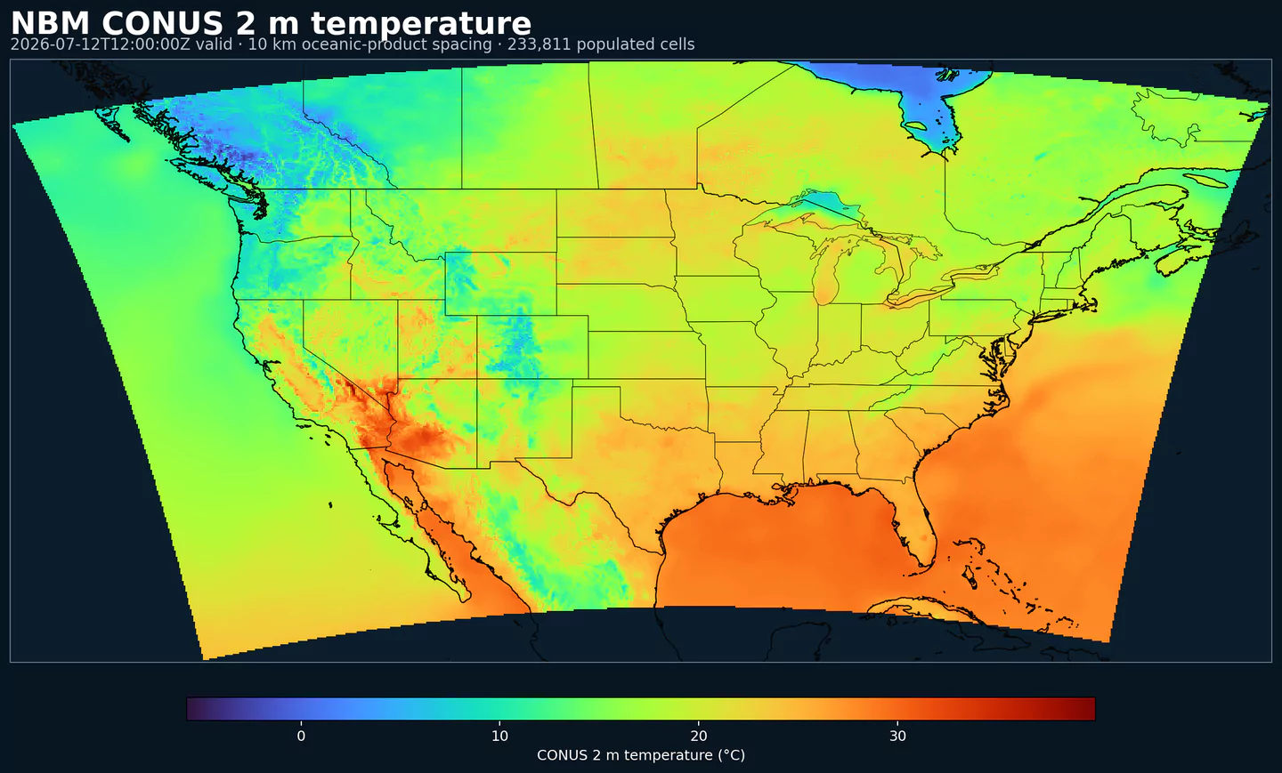
Air temperature is the thermal state of the atmosphere at the specified level. It influences density, stability, and energy exchange.
| Level | Info | Horizon | Introduced | Selector |
|---|---|---|---|---|
2 m above ground |
50% level |
2h-264h | 5 days ago |
{"name":"TMP","level":"2 m above ground","info":"50% level"}
|
surface |
2h-264h | 5 days ago |
{"name":"TMP","level":"surface","info":""}
|
Total precipitable water transport direction is the direction of column‑integrated moisture flux. It indicates moisture transport pathways.
| Level | Info | Horizon | Introduced | Selector |
|---|---|---|---|---|
10 m above ground |
2h-167h | 5 days ago |
{"name":"TPWDIR","level":"10 m above ground","info":""}
|
Total precipitable water transport speed is the magnitude of column‑integrated moisture transport. It highlights atmospheric river strength.
| Level | Info | Horizon | Introduced | Selector |
|---|---|---|---|---|
10 m above ground |
2h-167h | 5 days ago |
{"name":"TPWSPD","level":"10 m above ground","info":""}
|
Thunderstorm indicator flags the presence of thunderstorm conditions in the grid cell. It is used as a categorical hazard field.
| Level | Info | Horizon | Introduced | Selector |
|---|---|---|---|---|
surface |
probability forecast |
1h-192h | 5 days ago |
{"name":"TSTM","level":"surface","info":"probability forecast"}
|
Horizontal visibility at the surface. Lower values indicate reduced visibility due to fog, precipitation, or aerosols.
| Level | Info | Horizon | Introduced | Selector |
|---|---|---|---|---|
surface |
50% level |
2h-264h | 5 days ago |
{"name":"VIS","level":"surface","info":"50% level"}
|
Wind direction indicates the direction from which the wind is blowing at the specified level.
| Level | Info | Horizon | Introduced | Selector |
|---|---|---|---|---|
10 m above ground |
5h-264h | 5 days ago |
{"name":"WDIR","level":"10 m above ground","info":""}
|
|
10 m above ground |
50% level |
5h-264h | 5 days ago |
{"name":"WDIR","level":"10 m above ground","info":"50% level"}
|
10 m above ground |
75% level |
5h-264h | 5 days ago |
{"name":"WDIR","level":"10 m above ground","info":"75% level"}
|
10 m above ground |
90% level |
5h-264h | 5 days ago |
{"name":"WDIR","level":"10 m above ground","info":"90% level"}
|
30 m above ground |
50% level |
5h-264h | 5 days ago |
{"name":"WDIR","level":"30 m above ground","info":"50% level"}
|
80 m above ground |
50% level |
5h-264h | 5 days ago |
{"name":"WDIR","level":"80 m above ground","info":"50% level"}
|
Wind speed is the magnitude of the horizontal wind at the specified level. It is used for transport, mixing, and hazards.
| Level | Info | Horizon | Introduced | Selector |
|---|---|---|---|---|
10 m above ground |
5h-264h | 5 days ago |
{"name":"WIND","level":"10 m above ground","info":""}
|
|
10 m above ground |
10% level |
2h-264h | 5 days ago |
{"name":"WIND","level":"10 m above ground","info":"10% level"}
|
10 m above ground |
25% level |
2h-264h | 5 days ago |
{"name":"WIND","level":"10 m above ground","info":"25% level"}
|
10 m above ground |
50% level |
2h-264h | 5 days ago |
{"name":"WIND","level":"10 m above ground","info":"50% level"}
|
10 m above ground |
75% level |
2h-264h | 5 days ago |
{"name":"WIND","level":"10 m above ground","info":"75% level"}
|
10 m above ground |
90% level |
2h-264h | 5 days ago |
{"name":"WIND","level":"10 m above ground","info":"90% level"}
|
30 m above ground |
50% level |
2h-264h | 5 days ago |
{"name":"WIND","level":"30 m above ground","info":"50% level"}
|
80 m above ground |
50% level |
2h-264h | 5 days ago |
{"name":"WIND","level":"80 m above ground","info":"50% level"}
|
検索に一致するパラメータはありません。