Apparent temperature combines air temperature, humidity, and wind to estimate how hot or cold it feels to humans. It is useful for heat and cold stress assessments.
- Units: K.
GribStreamコード: nbmoc
他のNBM主要格子:
nbm, nbmak, nbmhi, nbmpr, nbmgu
NBM v5ステータス: このデータセットではNBM v5が運用版になっています。GribStreamアーカイブでは、2026-05-05 12:00 UTCより前のモデル実行は以前の運用NBM版を含み、2026-05-05 12:00 UTC以降のモデル実行はNBM v5を使います。
APCP、ASNOW、FICEACのような積算フィールドは、ソースに存在する場合、NBM v5で拡張された1時間ごとの予報範囲を通り、その後は/timeseriesでより長い積算期間に進みます。欠落や重複する期間を作らないように扱います。
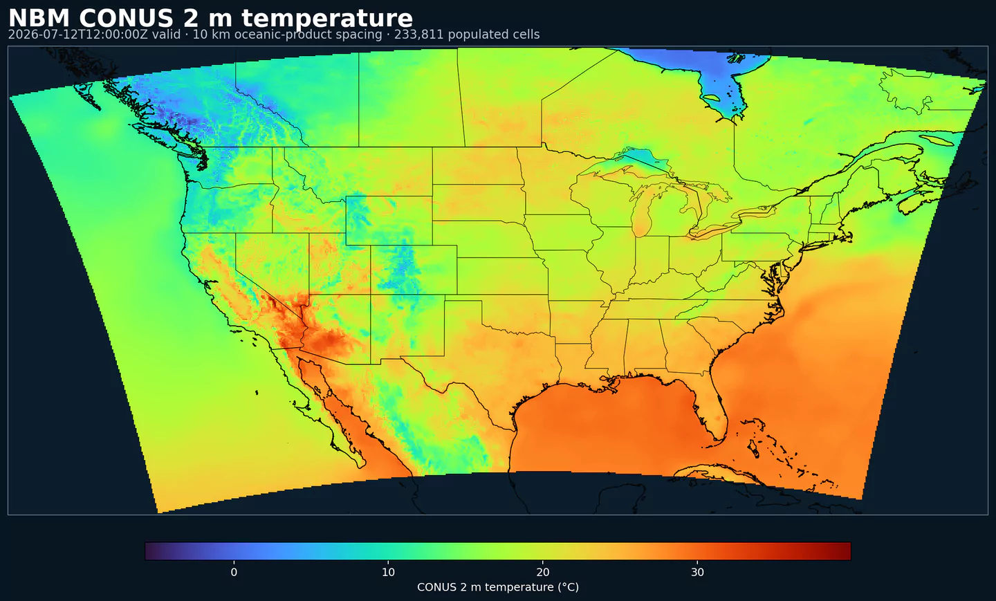
NBM Oceanicは、National Blend of ModelsのOceanic領域向け出力です。米国本土の主要格子ではなく、その対象領域に合わせた格子へNOAAの運用後処理を適用します。
NBMは複数の予報ソースを組み合わせ、統計的に較正することで、単一の未較正モデルより一貫したフィールドを作ります。目的は、天候リスクが意思決定に関わる運用プロダクトへ、より安定した予報基盤を提供することです。
システムはMOS(Model Output Statistics)、Quantile Mapping、アンサンブル重み付けなどの手法を使います。地域別のNBMでもAPIワークフローは同じで、対象地域のNBMデータセットを選び、他のNBMコードと同じカタログセレクタを使います。
GribStreamでは、nbmocがカタログの変数コード、level、info値をそのまま保持します。同じエンドポイントとセレクタの形を使い、モデルコードだけを切り替えられます。
パラメータをクリックすると、コピーしやすいJSONセレクタ付きのコンパクトな表で候補を確認できます。コード、level、selector値はAPIが公開する値をそのまま保持します。
Apparent temperature combines air temperature, humidity, and wind to estimate how hot or cold it feels to humans. It is useful for heat and cold stress assessments.
| Level | Info | Horizon | Introduced | Selector |
|---|---|---|---|---|
2 m above ground |
2h-264h | 2026-05-05 |
{"name":"APTMP","level":"2 m above ground","info":""}
|
Dew point temperature is the temperature at which the air becomes saturated. It is a direct measure of moisture content.
| Level | Info | Horizon | Introduced | Selector |
|---|---|---|---|---|
2 m above ground |
50% level |
2h-264h | 2026-05-05 |
{"name":"DPT","level":"2 m above ground","info":"50% level"}
|
Freezing spray indicator flags marine conditions favorable for ice accretion on vessels. It depends on wind, air temperature, and wave conditions.
| Level | Info | Horizon | Introduced | Selector |
|---|---|---|---|---|
surface |
2h-264h | 2024-04-15 |
{"name":"FRZSPR","level":"surface","info":""}
|
Wind gust is the peak short-duration wind speed. It captures brief, hazardous bursts that can exceed sustained winds.
| Level | Info | Horizon | Introduced | Selector |
|---|---|---|---|---|
10 m above ground |
50% level |
2h-264h | 2020-10-01 |
{"name":"GUST","level":"10 m above ground","info":"50% level"}
|
Significant wave height represents the average height of the highest third of waves. It is the standard metric for sea state and marine hazards.
| Level | Info | Horizon | Introduced | Selector |
|---|---|---|---|---|
surface |
2h-240h | 2020-10-01 |
{"name":"HTSGW","level":"surface","info":""}
|
|
surface |
10% level |
2h-240h | 2023-01-16 |
{"name":"HTSGW","level":"surface","info":"10% level"}
|
surface |
50% level |
2h-240h | 2023-01-16 |
{"name":"HTSGW","level":"surface","info":"50% level"}
|
surface |
90% level |
2h-240h | 2023-01-16 |
{"name":"HTSGW","level":"surface","info":"90% level"}
|
surface |
ens std dev |
2h-240h | 2020-10-01 |
{"name":"HTSGW","level":"surface","info":"ens std dev"}
|
Total cloud cover is the fraction of the grid cell covered by clouds at any level. It influences radiation, temperature, and visibility.
| Level | Info | Horizon | Introduced | Selector |
|---|---|---|---|---|
surface |
2h-264h | 2026-05-05 |
{"name":"TCDC","level":"surface","info":""}
|
|
surface |
ens std dev |
2h-264h | 2026-05-05 |
{"name":"TCDC","level":"surface","info":"ens std dev"}
|
Thunderstorm probability gives the chance of thunderstorms during the valid period. It is used for convective hazard guidance.
| Level | Info | Horizon | Introduced | Selector |
|---|---|---|---|---|
entire atmosphere |
1h-36h | 2023-01-16 |
{"name":"THUNC","level":"entire atmosphere","info":""}
|
Air temperature is the thermal state of the atmosphere at the specified level. It influences density, stability, and energy exchange.
| Level | Info | Horizon | Introduced | Selector |
|---|---|---|---|---|
2 m above ground |
50% level |
2h-264h | 2020-10-01 |
{"name":"TMP","level":"2 m above ground","info":"50% level"}
|
surface |
2h-264h | 2020-10-01 |
{"name":"TMP","level":"surface","info":""}
|
Total precipitable water transport direction is the direction of column‑integrated moisture flux. It indicates moisture transport pathways.
| Level | Info | Horizon | Introduced | Selector |
|---|---|---|---|---|
10 m above ground |
2h-167h | 2024-05-14 |
{"name":"TPWDIR","level":"10 m above ground","info":""}
|
Total precipitable water transport speed is the magnitude of column‑integrated moisture transport. It highlights atmospheric river strength.
| Level | Info | Horizon | Introduced | Selector |
|---|---|---|---|---|
10 m above ground |
2h-167h | 2024-05-14 |
{"name":"TPWSPD","level":"10 m above ground","info":""}
|
Thunderstorm indicator flags the presence of thunderstorm conditions in the grid cell. It is used as a categorical hazard field.
| Level | Info | Horizon | Introduced | Selector |
|---|---|---|---|---|
surface |
probability forecast |
1h-192h | 2020-10-01 |
{"name":"TSTM","level":"surface","info":"probability forecast"}
|
Horizontal visibility at the surface. Lower values indicate reduced visibility due to fog, precipitation, or aerosols.
| Level | Info | Horizon | Introduced | Selector |
|---|---|---|---|---|
surface |
50% level |
2h-264h | 2020-10-01 |
{"name":"VIS","level":"surface","info":"50% level"}
|
Wind direction indicates the direction from which the wind is blowing at the specified level.
| Level | Info | Horizon | Introduced | Selector |
|---|---|---|---|---|
10 m above ground |
5h-264h | 2020-10-01 |
{"name":"WDIR","level":"10 m above ground","info":""}
|
|
10 m above ground |
50% level |
5h-264h | 2020-10-01 |
{"name":"WDIR","level":"10 m above ground","info":"50% level"}
|
10 m above ground |
75% level |
5h-264h | 2020-10-01 |
{"name":"WDIR","level":"10 m above ground","info":"75% level"}
|
10 m above ground |
90% level |
5h-264h | 2020-10-01 |
{"name":"WDIR","level":"10 m above ground","info":"90% level"}
|
30 m above ground |
50% level |
5h-264h | 2020-10-01 |
{"name":"WDIR","level":"30 m above ground","info":"50% level"}
|
80 m above ground |
50% level |
5h-264h | 2020-10-01 |
{"name":"WDIR","level":"80 m above ground","info":"50% level"}
|
Wind speed is the magnitude of the horizontal wind at the specified level. It is used for transport, mixing, and hazards.
| Level | Info | Horizon | Introduced | Selector |
|---|---|---|---|---|
10 m above ground |
5h-264h | 2020-10-01 |
{"name":"WIND","level":"10 m above ground","info":""}
|
|
10 m above ground |
10% level |
2h-264h | 2020-10-01 |
{"name":"WIND","level":"10 m above ground","info":"10% level"}
|
10 m above ground |
25% level |
2h-264h | 2020-10-01 |
{"name":"WIND","level":"10 m above ground","info":"25% level"}
|
10 m above ground |
50% level |
2h-264h | 2020-10-01 |
{"name":"WIND","level":"10 m above ground","info":"50% level"}
|
10 m above ground |
75% level |
2h-264h | 2020-10-01 |
{"name":"WIND","level":"10 m above ground","info":"75% level"}
|
10 m above ground |
90% level |
2h-264h | 2020-10-01 |
{"name":"WIND","level":"10 m above ground","info":"90% level"}
|
30 m above ground |
50% level |
2h-264h | 2020-10-01 |
{"name":"WIND","level":"30 m above ground","info":"50% level"}
|
80 m above ground |
50% level |
2h-264h | 2020-10-01 |
{"name":"WIND","level":"80 m above ground","info":"50% level"}
|
検索に一致するパラメータはありません。