Apparent temperature combines air temperature, humidity, and wind to estimate how hot or cold it feels to humans. It is useful for heat and cold stress assessments.
- Units: K.
nbmoc
Other NBM core grids:
nbm,
nbmak,
nbmhi,
nbmpr,
nbmgu
NBM v5 status: NBM v5 is now operational in this dataset. In the GribStream archive, runs before 2026-05-05 12:00 UTC contain the previous operational NBM version; runs from 2026-05-05 12:00 UTC onward use NBM v5. Accumulation fields such as APCP, ASNOW, and FICEAC, where present, now continue through the expanded NBM v5 hourly range, then proceed with longer accumulation periods in /timeseries without gaps or duplicate windows.
NBM (National Blend of Models) is NOAA’s flagship post-processing system for gridded forecasts. This dataset exposes the Oceanic NBM core grid through the GribStream API, enabling large-window extractions without downloading GRIB files.
The blending is performed with statistically sophisticated techniques such as Model Output Statistics (MOS), quantile mapping, and ensemble weighting, producing calibrated gridded fields that support decision making workflows.
Click a parameter to reveal variants in a compact table with ready-to-copy JSON selectors.
Apparent temperature combines air temperature, humidity, and wind to estimate how hot or cold it feels to humans. It is useful for heat and cold stress assessments.
| Level | Info | Horizon | Introduced | Selector |
|---|---|---|---|---|
2 m above ground |
2h-264h | 2026-05-05 |
{"name":"APTMP","level":"2 m above ground","info":""}
|
Dew point temperature is the temperature at which the air becomes saturated. It is a direct measure of moisture content.
| Level | Info | Horizon | Introduced | Selector |
|---|---|---|---|---|
2 m above ground |
50% level |
2h-264h | 2026-05-05 |
{"name":"DPT","level":"2 m above ground","info":"50% level"}
|
Freezing spray indicator flags marine conditions favorable for ice accretion on vessels. It depends on wind, air temperature, and wave conditions.
| Level | Info | Horizon | Introduced | Selector |
|---|---|---|---|---|
surface |
2h-264h | 2024-04-15 |
{"name":"FRZSPR","level":"surface","info":""}
|
Wind gust is the peak short-duration wind speed. It captures brief, hazardous bursts that can exceed sustained winds.
| Level | Info | Horizon | Introduced | Selector |
|---|---|---|---|---|
10 m above ground |
50% level |
2h-264h | 2020-10-01 |
{"name":"GUST","level":"10 m above ground","info":"50% level"}
|
Significant wave height represents the average height of the highest third of waves. It is the standard metric for sea state and marine hazards.
| Level | Info | Horizon | Introduced | Selector |
|---|---|---|---|---|
surface |
2h-240h | 2020-10-01 |
{"name":"HTSGW","level":"surface","info":""}
|
|
surface |
10% level |
2h-240h | 2023-01-16 |
{"name":"HTSGW","level":"surface","info":"10% level"}
|
surface |
50% level |
2h-240h | 2023-01-16 |
{"name":"HTSGW","level":"surface","info":"50% level"}
|
surface |
90% level |
2h-240h | 2023-01-16 |
{"name":"HTSGW","level":"surface","info":"90% level"}
|
surface |
ens std dev |
2h-240h | 2020-10-01 |
{"name":"HTSGW","level":"surface","info":"ens std dev"}
|
Total cloud cover is the fraction of the grid cell covered by clouds at any level. It influences radiation, temperature, and visibility.
| Level | Info | Horizon | Introduced | Selector |
|---|---|---|---|---|
surface |
2h-264h | 2026-05-05 |
{"name":"TCDC","level":"surface","info":""}
|
|
surface |
ens std dev |
2h-264h | 2026-05-05 |
{"name":"TCDC","level":"surface","info":"ens std dev"}
|
Thunderstorm probability gives the chance of thunderstorms during the valid period. It is used for convective hazard guidance.
| Level | Info | Horizon | Introduced | Selector |
|---|---|---|---|---|
entire atmosphere |
1h-36h | 2023-01-16 |
{"name":"THUNC","level":"entire atmosphere","info":""}
|
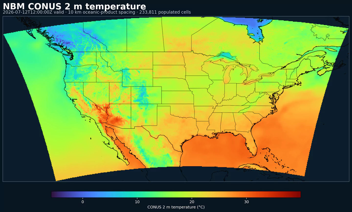
Air temperature is the thermal state of the atmosphere at the specified level. It influences density, stability, and energy exchange.
| Level | Info | Horizon | Introduced | Selector |
|---|---|---|---|---|
2 m above ground |
50% level |
2h-264h | 2020-10-01 |
{"name":"TMP","level":"2 m above ground","info":"50% level"}
|
surface |
2h-264h | 2020-10-01 |
{"name":"TMP","level":"surface","info":""}
|
Total precipitable water transport direction is the direction of column‑integrated moisture flux. It indicates moisture transport pathways.
| Level | Info | Horizon | Introduced | Selector |
|---|---|---|---|---|
10 m above ground |
2h-167h | 2024-05-14 |
{"name":"TPWDIR","level":"10 m above ground","info":""}
|
Total precipitable water transport speed is the magnitude of column‑integrated moisture transport. It highlights atmospheric river strength.
| Level | Info | Horizon | Introduced | Selector |
|---|---|---|---|---|
10 m above ground |
2h-167h | 2024-05-14 |
{"name":"TPWSPD","level":"10 m above ground","info":""}
|
Thunderstorm indicator flags the presence of thunderstorm conditions in the grid cell. It is used as a categorical hazard field.
| Level | Info | Horizon | Introduced | Selector |
|---|---|---|---|---|
surface |
probability forecast |
1h-192h | 2020-10-01 |
{"name":"TSTM","level":"surface","info":"probability forecast"}
|
Horizontal visibility at the surface. Lower values indicate reduced visibility due to fog, precipitation, or aerosols.
| Level | Info | Horizon | Introduced | Selector |
|---|---|---|---|---|
surface |
50% level |
2h-264h | 2020-10-01 |
{"name":"VIS","level":"surface","info":"50% level"}
|
Wind direction indicates the direction from which the wind is blowing at the specified level.
| Level | Info | Horizon | Introduced | Selector |
|---|---|---|---|---|
10 m above ground |
5h-264h | 2020-10-01 |
{"name":"WDIR","level":"10 m above ground","info":""}
|
|
10 m above ground |
50% level |
5h-264h | 2020-10-01 |
{"name":"WDIR","level":"10 m above ground","info":"50% level"}
|
10 m above ground |
75% level |
5h-264h | 2020-10-01 |
{"name":"WDIR","level":"10 m above ground","info":"75% level"}
|
10 m above ground |
90% level |
5h-264h | 2020-10-01 |
{"name":"WDIR","level":"10 m above ground","info":"90% level"}
|
30 m above ground |
50% level |
5h-264h | 2020-10-01 |
{"name":"WDIR","level":"30 m above ground","info":"50% level"}
|
80 m above ground |
50% level |
5h-264h | 2020-10-01 |
{"name":"WDIR","level":"80 m above ground","info":"50% level"}
|
Wind speed is the magnitude of the horizontal wind at the specified level. It is used for transport, mixing, and hazards.
| Level | Info | Horizon | Introduced | Selector |
|---|---|---|---|---|
10 m above ground |
5h-264h | 2020-10-01 |
{"name":"WIND","level":"10 m above ground","info":""}
|
|
10 m above ground |
10% level |
2h-264h | 2020-10-01 |
{"name":"WIND","level":"10 m above ground","info":"10% level"}
|
10 m above ground |
25% level |
2h-264h | 2020-10-01 |
{"name":"WIND","level":"10 m above ground","info":"25% level"}
|
10 m above ground |
50% level |
2h-264h | 2020-10-01 |
{"name":"WIND","level":"10 m above ground","info":"50% level"}
|
10 m above ground |
75% level |
2h-264h | 2020-10-01 |
{"name":"WIND","level":"10 m above ground","info":"75% level"}
|
10 m above ground |
90% level |
2h-264h | 2020-10-01 |
{"name":"WIND","level":"10 m above ground","info":"90% level"}
|
30 m above ground |
50% level |
2h-264h | 2020-10-01 |
{"name":"WIND","level":"30 m above ground","info":"50% level"}
|
80 m above ground |
50% level |
2h-264h | 2020-10-01 |
{"name":"WIND","level":"80 m above ground","info":"50% level"}
|
No parameters match your search.