Apparent temperature combines air temperature, humidity, and wind to estimate how hot or cold it feels to humans. It is useful for heat and cold stress assessments.
- Units: K.
Código GribStream: nbmoc
Outras grades NBM:
nbm, nbmak, nbmhi, nbmpr, nbmgu
Status do NBM v5: o NBM v5 já está operacional neste dataset. No arquivo do GribStream, execuções anteriores a 2026-05-05 12:00 UTC contêm a versão operacional anterior do NBM; execuções a partir de 2026-05-05 12:00 UTC usam o NBM v5.
Campos de acumulação como APCP, ASNOW e FICEAC, quando presentes, continuam pela faixa horária ampliada do NBM v5 e depois seguem em /timeseries com períodos de acumulação mais longos, sem lacunas nem janelas duplicadas.
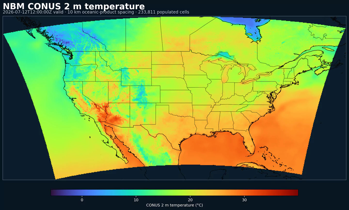
NBM Oceanic é a saída regional do National Blend of Models para a região oceânica. Ela leva o pós-processamento operacional da NOAA a uma grade focada nesse domínio, em vez de usar a grade CONUS principal.
O NBM combina várias fontes de previsão e aplica calibração estatística para produzir campos mais consistentes do que os de um modelo individual sem calibração. O objetivo é entregar uma base de previsão mais estável para produtos operacionais e decisões em que o risco meteorológico importa.
O sistema usa técnicas como Model Output Statistics (MOS), Quantile Mapping e ponderação de ensemble. Nos domínios regionais, essa mistura mantém uma orientação local útil sem mudar o jeito de consultar a API.
No GribStream, nbmoc preserva os códigos de variável, níveis e valores de info do catálogo. Você pode usar os mesmos endpoints e seletores dos outros códigos NBM, mudando apenas o código do modelo.
Clique em um parâmetro para ver as variantes em uma tabela compacta, com seletores JSON prontos para copiar. Códigos, níveis e valores do seletor ficam exatamente como a API expõe.
Apparent temperature combines air temperature, humidity, and wind to estimate how hot or cold it feels to humans. It is useful for heat and cold stress assessments.
| Level | Info | Horizon | Introduced | Selector |
|---|---|---|---|---|
2 m above ground |
2h-264h | 2026-05-05 |
{"name":"APTMP","level":"2 m above ground","info":""}
|
Dew point temperature is the temperature at which the air becomes saturated. It is a direct measure of moisture content.
| Level | Info | Horizon | Introduced | Selector |
|---|---|---|---|---|
2 m above ground |
50% level |
2h-264h | 2026-05-05 |
{"name":"DPT","level":"2 m above ground","info":"50% level"}
|
Freezing spray indicator flags marine conditions favorable for ice accretion on vessels. It depends on wind, air temperature, and wave conditions.
| Level | Info | Horizon | Introduced | Selector |
|---|---|---|---|---|
surface |
2h-264h | 2024-04-15 |
{"name":"FRZSPR","level":"surface","info":""}
|
Wind gust is the peak short-duration wind speed. It captures brief, hazardous bursts that can exceed sustained winds.
| Level | Info | Horizon | Introduced | Selector |
|---|---|---|---|---|
10 m above ground |
50% level |
2h-264h | 2020-10-01 |
{"name":"GUST","level":"10 m above ground","info":"50% level"}
|
Significant wave height represents the average height of the highest third of waves. It is the standard metric for sea state and marine hazards.
| Level | Info | Horizon | Introduced | Selector |
|---|---|---|---|---|
surface |
2h-240h | 2020-10-01 |
{"name":"HTSGW","level":"surface","info":""}
|
|
surface |
10% level |
2h-240h | 2023-01-16 |
{"name":"HTSGW","level":"surface","info":"10% level"}
|
surface |
50% level |
2h-240h | 2023-01-16 |
{"name":"HTSGW","level":"surface","info":"50% level"}
|
surface |
90% level |
2h-240h | 2023-01-16 |
{"name":"HTSGW","level":"surface","info":"90% level"}
|
surface |
ens std dev |
2h-240h | 2020-10-01 |
{"name":"HTSGW","level":"surface","info":"ens std dev"}
|
Total cloud cover is the fraction of the grid cell covered by clouds at any level. It influences radiation, temperature, and visibility.
| Level | Info | Horizon | Introduced | Selector |
|---|---|---|---|---|
surface |
2h-264h | 2026-05-05 |
{"name":"TCDC","level":"surface","info":""}
|
|
surface |
ens std dev |
2h-264h | 2026-05-05 |
{"name":"TCDC","level":"surface","info":"ens std dev"}
|
Thunderstorm probability gives the chance of thunderstorms during the valid period. It is used for convective hazard guidance.
| Level | Info | Horizon | Introduced | Selector |
|---|---|---|---|---|
entire atmosphere |
1h-36h | 2023-01-16 |
{"name":"THUNC","level":"entire atmosphere","info":""}
|
Air temperature is the thermal state of the atmosphere at the specified level. It influences density, stability, and energy exchange.
| Level | Info | Horizon | Introduced | Selector |
|---|---|---|---|---|
2 m above ground |
50% level |
2h-264h | 2020-10-01 |
{"name":"TMP","level":"2 m above ground","info":"50% level"}
|
surface |
2h-264h | 2020-10-01 |
{"name":"TMP","level":"surface","info":""}
|
Total precipitable water transport direction is the direction of column‑integrated moisture flux. It indicates moisture transport pathways.
| Level | Info | Horizon | Introduced | Selector |
|---|---|---|---|---|
10 m above ground |
2h-167h | 2024-05-14 |
{"name":"TPWDIR","level":"10 m above ground","info":""}
|
Total precipitable water transport speed is the magnitude of column‑integrated moisture transport. It highlights atmospheric river strength.
| Level | Info | Horizon | Introduced | Selector |
|---|---|---|---|---|
10 m above ground |
2h-167h | 2024-05-14 |
{"name":"TPWSPD","level":"10 m above ground","info":""}
|
Thunderstorm indicator flags the presence of thunderstorm conditions in the grid cell. It is used as a categorical hazard field.
| Level | Info | Horizon | Introduced | Selector |
|---|---|---|---|---|
surface |
probability forecast |
1h-192h | 2020-10-01 |
{"name":"TSTM","level":"surface","info":"probability forecast"}
|
Horizontal visibility at the surface. Lower values indicate reduced visibility due to fog, precipitation, or aerosols.
| Level | Info | Horizon | Introduced | Selector |
|---|---|---|---|---|
surface |
50% level |
2h-264h | 2020-10-01 |
{"name":"VIS","level":"surface","info":"50% level"}
|
Wind direction indicates the direction from which the wind is blowing at the specified level.
| Level | Info | Horizon | Introduced | Selector |
|---|---|---|---|---|
10 m above ground |
5h-264h | 2020-10-01 |
{"name":"WDIR","level":"10 m above ground","info":""}
|
|
10 m above ground |
50% level |
5h-264h | 2020-10-01 |
{"name":"WDIR","level":"10 m above ground","info":"50% level"}
|
10 m above ground |
75% level |
5h-264h | 2020-10-01 |
{"name":"WDIR","level":"10 m above ground","info":"75% level"}
|
10 m above ground |
90% level |
5h-264h | 2020-10-01 |
{"name":"WDIR","level":"10 m above ground","info":"90% level"}
|
30 m above ground |
50% level |
5h-264h | 2020-10-01 |
{"name":"WDIR","level":"30 m above ground","info":"50% level"}
|
80 m above ground |
50% level |
5h-264h | 2020-10-01 |
{"name":"WDIR","level":"80 m above ground","info":"50% level"}
|
Wind speed is the magnitude of the horizontal wind at the specified level. It is used for transport, mixing, and hazards.
| Level | Info | Horizon | Introduced | Selector |
|---|---|---|---|---|
10 m above ground |
5h-264h | 2020-10-01 |
{"name":"WIND","level":"10 m above ground","info":""}
|
|
10 m above ground |
10% level |
2h-264h | 2020-10-01 |
{"name":"WIND","level":"10 m above ground","info":"10% level"}
|
10 m above ground |
25% level |
2h-264h | 2020-10-01 |
{"name":"WIND","level":"10 m above ground","info":"25% level"}
|
10 m above ground |
50% level |
2h-264h | 2020-10-01 |
{"name":"WIND","level":"10 m above ground","info":"50% level"}
|
10 m above ground |
75% level |
2h-264h | 2020-10-01 |
{"name":"WIND","level":"10 m above ground","info":"75% level"}
|
10 m above ground |
90% level |
2h-264h | 2020-10-01 |
{"name":"WIND","level":"10 m above ground","info":"90% level"}
|
30 m above ground |
50% level |
2h-264h | 2020-10-01 |
{"name":"WIND","level":"30 m above ground","info":"50% level"}
|
80 m above ground |
50% level |
2h-264h | 2020-10-01 |
{"name":"WIND","level":"80 m above ground","info":"50% level"}
|
Nenhum parâmetro corresponde à busca.