Apparent temperature combines air temperature, humidity, and wind to estimate how hot or cold it feels to humans. It is useful for heat and cold stress assessments.
- Units: K.
Codice GribStream: nbmoc
Altre griglie NBM:
nbm, nbmak, nbmhi, nbmpr, nbmgu
Status NBM v5: NBM v5 è già operativo in questo dataset. Nell'archivio GribStream, i run precedenti a 2026-05-05 12:00 UTC contengono la versione operativa precedente di NBM; i run da 2026-05-05 12:00 UTC in poi usano NBM v5.
I campi di accumulo come APCP, ASNOW e FICEAC, quando presenti, continuano nella finestra oraria estesa di NBM v5 e poi proseguono in /timeseries con periodi di accumulo più lunghi, senza lacune o finestre duplicate.
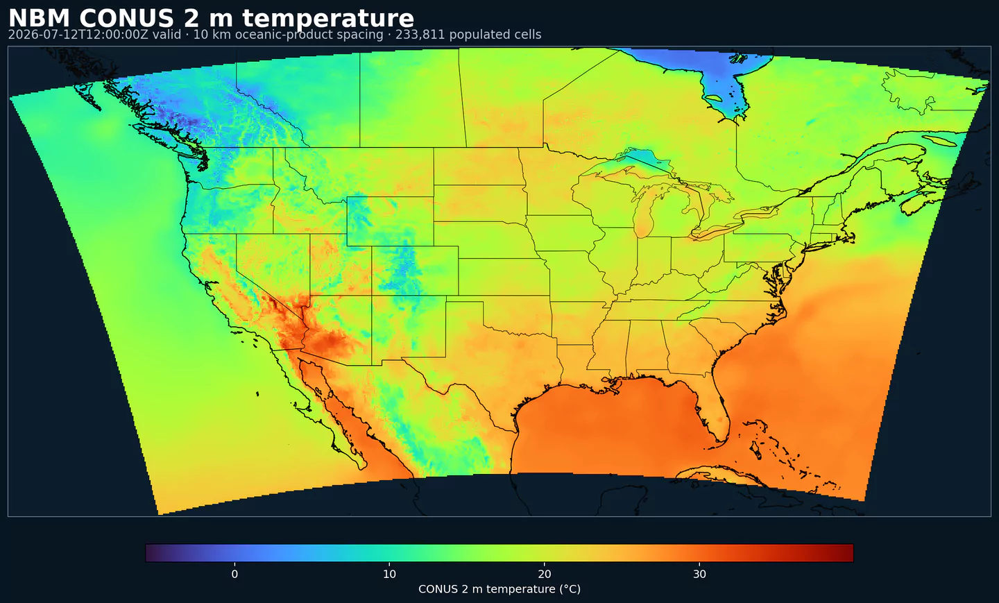
NBM Oceanic è il prodotto regionale del National Blend of Models per la regione oceanica. Porta la post-elaborazione operativa NOAA su una griglia dedicata al dominio, invece di usare la griglia CONUS principale.
NBM combina più fonti di previsione e applica calibrazione statistica per produrre campi più consistenti di quelli di un singolo modello non calibrato. L'obiettivo è offrire una base previsionale più stabile per prodotti operativi e decisioni sensibili al rischio meteo.
Il sistema usa tecniche come Model Output Statistics (MOS), Quantile Mapping e pesatura ensemble. Nei domini regionali, questo blend mantiene un contesto locale utile senza cambiare il modo in cui si interroga l'API.
In GribStream, nbmoc preserva codici variabile, livelli e valori di info del catalogo. Puoi usare gli stessi endpoint e selettori degli altri codici NBM, cambiando solo il codice del modello.
Fai clic su un parametro per vedere le varianti in una tabella compatta con selettori JSON pronti da copiare. Codici, livelli e valori dei selettori restano esattamente come li espone l'API.
Apparent temperature combines air temperature, humidity, and wind to estimate how hot or cold it feels to humans. It is useful for heat and cold stress assessments.
| Level | Info | Horizon | Introduced | Selector |
|---|---|---|---|---|
2 m above ground |
2h-264h | 2026-05-05 |
{"name":"APTMP","level":"2 m above ground","info":""}
|
Dew point temperature is the temperature at which the air becomes saturated. It is a direct measure of moisture content.
| Level | Info | Horizon | Introduced | Selector |
|---|---|---|---|---|
2 m above ground |
50% level |
2h-264h | 2026-05-05 |
{"name":"DPT","level":"2 m above ground","info":"50% level"}
|
Freezing spray indicator flags marine conditions favorable for ice accretion on vessels. It depends on wind, air temperature, and wave conditions.
| Level | Info | Horizon | Introduced | Selector |
|---|---|---|---|---|
surface |
2h-264h | 2024-04-15 |
{"name":"FRZSPR","level":"surface","info":""}
|
Wind gust is the peak short-duration wind speed. It captures brief, hazardous bursts that can exceed sustained winds.
| Level | Info | Horizon | Introduced | Selector |
|---|---|---|---|---|
10 m above ground |
50% level |
2h-264h | 2020-10-01 |
{"name":"GUST","level":"10 m above ground","info":"50% level"}
|
Significant wave height represents the average height of the highest third of waves. It is the standard metric for sea state and marine hazards.
| Level | Info | Horizon | Introduced | Selector |
|---|---|---|---|---|
surface |
2h-240h | 2020-10-01 |
{"name":"HTSGW","level":"surface","info":""}
|
|
surface |
10% level |
2h-240h | 2023-01-16 |
{"name":"HTSGW","level":"surface","info":"10% level"}
|
surface |
50% level |
2h-240h | 2023-01-16 |
{"name":"HTSGW","level":"surface","info":"50% level"}
|
surface |
90% level |
2h-240h | 2023-01-16 |
{"name":"HTSGW","level":"surface","info":"90% level"}
|
surface |
ens std dev |
2h-240h | 2020-10-01 |
{"name":"HTSGW","level":"surface","info":"ens std dev"}
|
Total cloud cover is the fraction of the grid cell covered by clouds at any level. It influences radiation, temperature, and visibility.
| Level | Info | Horizon | Introduced | Selector |
|---|---|---|---|---|
surface |
2h-264h | 2026-05-05 |
{"name":"TCDC","level":"surface","info":""}
|
|
surface |
ens std dev |
2h-264h | 2026-05-05 |
{"name":"TCDC","level":"surface","info":"ens std dev"}
|
Thunderstorm probability gives the chance of thunderstorms during the valid period. It is used for convective hazard guidance.
| Level | Info | Horizon | Introduced | Selector |
|---|---|---|---|---|
entire atmosphere |
1h-36h | 2023-01-16 |
{"name":"THUNC","level":"entire atmosphere","info":""}
|
Air temperature is the thermal state of the atmosphere at the specified level. It influences density, stability, and energy exchange.
| Level | Info | Horizon | Introduced | Selector |
|---|---|---|---|---|
2 m above ground |
50% level |
2h-264h | 2020-10-01 |
{"name":"TMP","level":"2 m above ground","info":"50% level"}
|
surface |
2h-264h | 2020-10-01 |
{"name":"TMP","level":"surface","info":""}
|
Total precipitable water transport direction is the direction of column‑integrated moisture flux. It indicates moisture transport pathways.
| Level | Info | Horizon | Introduced | Selector |
|---|---|---|---|---|
10 m above ground |
2h-167h | 2024-05-14 |
{"name":"TPWDIR","level":"10 m above ground","info":""}
|
Total precipitable water transport speed is the magnitude of column‑integrated moisture transport. It highlights atmospheric river strength.
| Level | Info | Horizon | Introduced | Selector |
|---|---|---|---|---|
10 m above ground |
2h-167h | 2024-05-14 |
{"name":"TPWSPD","level":"10 m above ground","info":""}
|
Thunderstorm indicator flags the presence of thunderstorm conditions in the grid cell. It is used as a categorical hazard field.
| Level | Info | Horizon | Introduced | Selector |
|---|---|---|---|---|
surface |
probability forecast |
1h-192h | 2020-10-01 |
{"name":"TSTM","level":"surface","info":"probability forecast"}
|
Horizontal visibility at the surface. Lower values indicate reduced visibility due to fog, precipitation, or aerosols.
| Level | Info | Horizon | Introduced | Selector |
|---|---|---|---|---|
surface |
50% level |
2h-264h | 2020-10-01 |
{"name":"VIS","level":"surface","info":"50% level"}
|
Wind direction indicates the direction from which the wind is blowing at the specified level.
| Level | Info | Horizon | Introduced | Selector |
|---|---|---|---|---|
10 m above ground |
5h-264h | 2020-10-01 |
{"name":"WDIR","level":"10 m above ground","info":""}
|
|
10 m above ground |
50% level |
5h-264h | 2020-10-01 |
{"name":"WDIR","level":"10 m above ground","info":"50% level"}
|
10 m above ground |
75% level |
5h-264h | 2020-10-01 |
{"name":"WDIR","level":"10 m above ground","info":"75% level"}
|
10 m above ground |
90% level |
5h-264h | 2020-10-01 |
{"name":"WDIR","level":"10 m above ground","info":"90% level"}
|
30 m above ground |
50% level |
5h-264h | 2020-10-01 |
{"name":"WDIR","level":"30 m above ground","info":"50% level"}
|
80 m above ground |
50% level |
5h-264h | 2020-10-01 |
{"name":"WDIR","level":"80 m above ground","info":"50% level"}
|
Wind speed is the magnitude of the horizontal wind at the specified level. It is used for transport, mixing, and hazards.
| Level | Info | Horizon | Introduced | Selector |
|---|---|---|---|---|
10 m above ground |
5h-264h | 2020-10-01 |
{"name":"WIND","level":"10 m above ground","info":""}
|
|
10 m above ground |
10% level |
2h-264h | 2020-10-01 |
{"name":"WIND","level":"10 m above ground","info":"10% level"}
|
10 m above ground |
25% level |
2h-264h | 2020-10-01 |
{"name":"WIND","level":"10 m above ground","info":"25% level"}
|
10 m above ground |
50% level |
2h-264h | 2020-10-01 |
{"name":"WIND","level":"10 m above ground","info":"50% level"}
|
10 m above ground |
75% level |
2h-264h | 2020-10-01 |
{"name":"WIND","level":"10 m above ground","info":"75% level"}
|
10 m above ground |
90% level |
2h-264h | 2020-10-01 |
{"name":"WIND","level":"10 m above ground","info":"90% level"}
|
30 m above ground |
50% level |
2h-264h | 2020-10-01 |
{"name":"WIND","level":"30 m above ground","info":"50% level"}
|
80 m above ground |
50% level |
2h-264h | 2020-10-01 |
{"name":"WIND","level":"80 m above ground","info":"50% level"}
|
Nessun parametro corrisponde alla ricerca.