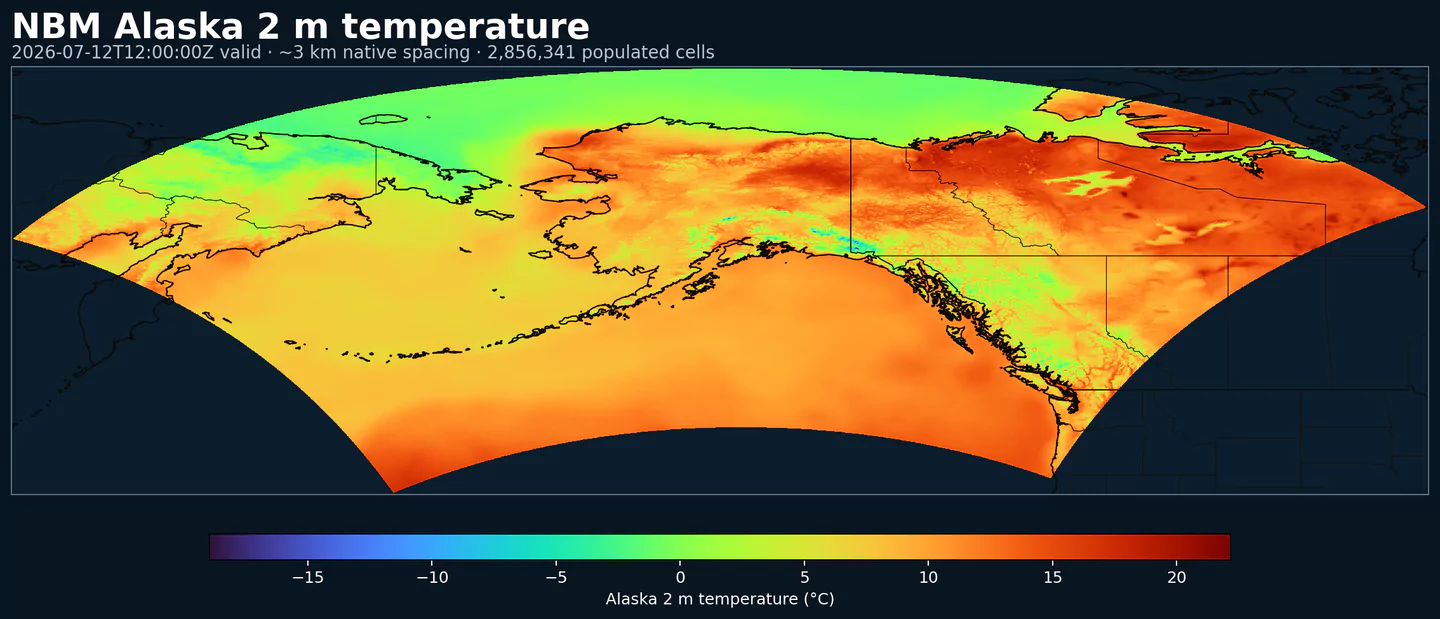
Representative Alaska coverage: NBM 2 m temperature across the complete populated grid at approximately 3 km spacing, with black country boundaries. This plot was generated from the nbmak dataset.
Status NBM v5: NBM v5 è già operativo in questo dataset. Nell'archivio GribStream, i run precedenti a 2026-05-05 12:00 UTC contengono la versione operativa precedente di NBM; i run da 2026-05-05 12:00 UTC in poi usano NBM v5.
I campi di accumulo come APCP, ASNOW e FICEAC, quando presenti, continuano nella finestra oraria estesa di NBM v5 e poi proseguono in /timeseries con periodi di accumulo più lunghi, senza lacune o finestre duplicate.
Descrizione
NBM Alaska è il prodotto regionale del National Blend of Models per Alaska. Porta la post-elaborazione operativa NOAA su una griglia dedicata al dominio, invece di usare la griglia CONUS principale.
NBM combina più fonti di previsione e applica calibrazione statistica per produrre campi più consistenti di quelli di un singolo modello non calibrato. L'obiettivo è offrire una base previsionale più stabile per prodotti operativi e decisioni sensibili al rischio meteo.
Il sistema usa tecniche come Model Output Statistics (MOS), Quantile Mapping e pesatura ensemble. Nei domini regionali, questo blend mantiene un contesto locale utile senza cambiare il modo in cui si interroga l'API.
In GribStream, nbmak preserva codici variabile, livelli e valori di info del catalogo. Puoi usare gli stessi endpoint e selettori degli altri codici NBM, cambiando solo il codice del modello.
Estende la base operativa di NBM v5 al dominio regionale Alaska.
Pubblica cicli orari per prodotti che richiedono aggiornamenti frequenti.
Combina modelli globali, regionali, deterministici ed ensemble in una previsione calibrata.
Usa gli stessi schemi di richiesta GribStream del NBM CONUS, con un proprio codice dataset.
Risoluzione: Circa 3 km sulla griglia regionale dell'Alaska.
Copertura temporale: Aggiornamenti orari; gli orizzonti di previsione arrivano a 264 h, circa 11 giorni, quando la fonte pubblica quei lead time.
Usi principali: Operazioni in Alaska, energia, aviazione, logistica, pianificazione emergenze, idrologia regionale e prodotti decisionali che richiedono NBM fuori da CONUS.
Fai clic su un parametro per vedere le varianti in una tabella compatta con selettori JSON pronti da copiare. Codici, livelli e valori dei selettori restano esattamente come li espone l'API.
Accumulated precipitation represents the total water-equivalent amount of rain and snow during the output period. It is a primary field for hydrologic impacts and event totals.
Units: kg/m^2.
Use with the model time interval to interpret totals and compare to gauges.
Apparent temperature combines air temperature, humidity, and wind to estimate how hot or cold it feels to humans. It is useful for heat and cold stress assessments.
Units: K.
Level
Info
Horizon
Introduced
Selector
2 m above ground
1h-264h
2020-10-01
{"name":"APTMP","level":"2 m above ground","info":""}
Convective Available Potential Energy (CAPE) quantifies buoyant energy available to rising air parcels. Larger values generally imply stronger potential updrafts and greater convective intensity.
Units: J/kg.
Often used with CIN and lifting mechanisms to assess thunderstorm potential.
Ceiling height is the altitude of the lowest cloud base that covers a significant portion of the sky. It is a key aviation and surface-visibility metric.
Distance to feature is the horizontal distance to the named hazard or boundary in the source product. It is used to map proximity to key features like fronts or hazards.
Units: km.
Level
Info
Horizon
Introduced
Selector
surface - 610 m above ground
1h-36h
2020-10-01
{"name":"DIST","level":"surface - 610 m above ground","info":""}
Ellrod index is a diagnostic for clear-air turbulence based on deformation and vertical wind shear. Higher values indicate greater turbulence potential for aviation.
Fosberg fire weather index combines temperature, humidity, and wind to estimate potential fire spread. Higher values indicate more favorable wildfire conditions.
Haines Index combines atmospheric stability and dryness to estimate the potential for large fire growth. Higher values indicate a more favorable environment for extreme fire behavior.
Units: Numeric.
Typically used in wildfire forecasting and risk monitoring.
Level
Info
Horizon
Introduced
Selector
entire atmosphere (considered as a single layer)
6h-264h
2020-10-01
{"name":"HINDEX","level":"entire atmosphere (considered as a single layer)","info":""}
Hourly maximum simulated reflectivity at 1 km AGL captures the strongest modeled reflectivity near the surface. It is used to identify peak convective intensity and heavy precipitation cores.
Units: dBZ.
Level
Info
Horizon
Introduced
Selector
1000 m above ground
1h-48h
2020-10-01
{"name":"MAXREF","level":"1000 m above ground","info":""}
Coded surface precipitation type derived from model precipitation and near-surface thermodynamics. It distinguishes rain, snow, freezing rain, mixed types, and related categories.
Units: coded.
Interpret together with precipitation rate or accumulation.