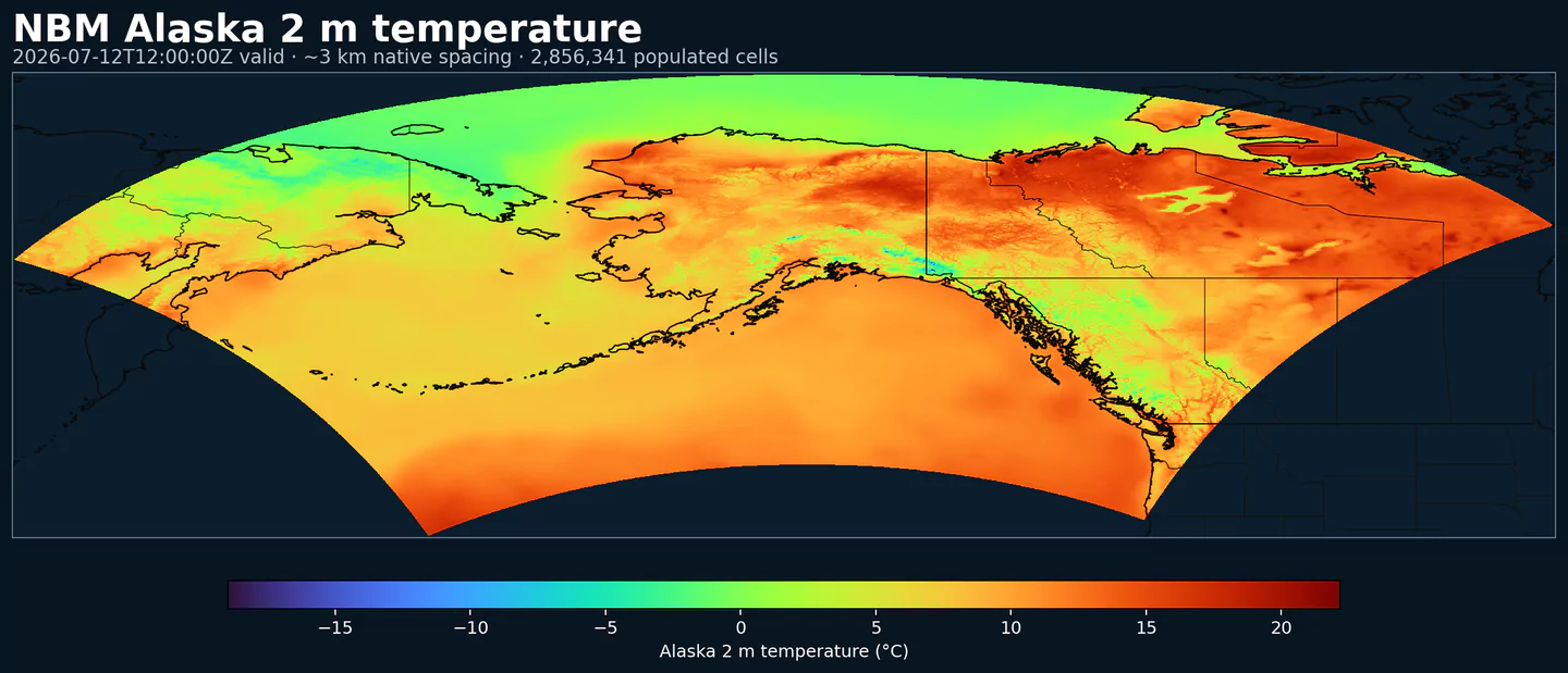
Representative Alaska coverage: NBM 2 m temperature across the complete populated grid at approximately 3 km spacing, with black country boundaries. This plot was generated from the nbmak dataset.
Estado de NBM v5: NBM v5 ya está operativo en este dataset. En el archivo de GribStream, las ejecuciones anteriores a 2026-05-05 12:00 UTC contienen la versión operativa anterior de NBM; las ejecuciones desde 2026-05-05 12:00 UTC en adelante usan NBM v5.
Los campos de acumulación como APCP, ASNOW y FICEAC, cuando están presentes, continúan a través del rango horario ampliado de NBM v5 y luego siguen con períodos de acumulación más largos en /timeseries, sin huecos ni ventanas duplicadas.
Descripción
NBM Alaska es la salida regional del National Blend of Models para Alaska. Lleva el postprocesamiento operativo de NOAA a una grilla enfocada en esa zona, en vez de usar la grilla CONUS principal.
NBM combina múltiples fuentes de pronóstico y aplica calibración estadística para producir campos más consistentes que los de un modelo individual sin calibración. El objetivo es entregar una guía más estable para productos operativos y decisiones donde el pronóstico condiciona el riesgo.
El sistema usa técnicas como Model Output Statistics (MOS), mapeo de cuantiles y ponderación de ensemble. En los dominios regionales, esa mezcla permite mantener una guía local útil sin cambiar cómo consultas la API.
En GribStream, nbmak conserva los códigos de variable, niveles y valores de info del catálogo. Puedes usar los mismos endpoints y selectores que en otros códigos NBM, cambiando solo el código del modelo.
Extiende la guía operativa de NBM v5 al dominio de Alaska.
Publica ciclos horarios para productos que necesitan actualizaciones frecuentes.
Combina modelos globales, regionales, determinísticos y de ensemble en una salida calibrada.
Mantiene los mismos patrones de consulta de GribStream que NBM CONUS, usando su propio código de modelo.
Resolución: Aproximadamente 3 km en la grilla regional de Alaska.
Cobertura temporal: Actualizaciones horarias; los horizontes de pronóstico llegan hasta 264 h, alrededor de 11 días, cuando la fuente publica esos plazos.
Usos principales: Operaciones en Alaska, energía, aviación, logística, planificación de emergencias, hidrología regional y productos de decisión que necesitan guía NBM fuera de CONUS.
Haz clic en un parámetro para ver sus variantes en una tabla compacta con selectores JSON listos para copiar. Los códigos, niveles y valores de selector se mantienen exactamente como los expone la API.
Accumulated precipitation represents the total water-equivalent amount of rain and snow during the output period. It is a primary field for hydrologic impacts and event totals.
Units: kg/m^2.
Use with the model time interval to interpret totals and compare to gauges.
Apparent temperature combines air temperature, humidity, and wind to estimate how hot or cold it feels to humans. It is useful for heat and cold stress assessments.
Units: K.
Level
Info
Horizon
Introduced
Selector
2 m above ground
1h-264h
2020-10-01
{"name":"APTMP","level":"2 m above ground","info":""}
Convective Available Potential Energy (CAPE) quantifies buoyant energy available to rising air parcels. Larger values generally imply stronger potential updrafts and greater convective intensity.
Units: J/kg.
Often used with CIN and lifting mechanisms to assess thunderstorm potential.
Ceiling height is the altitude of the lowest cloud base that covers a significant portion of the sky. It is a key aviation and surface-visibility metric.
Distance to feature is the horizontal distance to the named hazard or boundary in the source product. It is used to map proximity to key features like fronts or hazards.
Units: km.
Level
Info
Horizon
Introduced
Selector
surface - 610 m above ground
1h-36h
2020-10-01
{"name":"DIST","level":"surface - 610 m above ground","info":""}
Ellrod index is a diagnostic for clear-air turbulence based on deformation and vertical wind shear. Higher values indicate greater turbulence potential for aviation.
Fosberg fire weather index combines temperature, humidity, and wind to estimate potential fire spread. Higher values indicate more favorable wildfire conditions.
Haines Index combines atmospheric stability and dryness to estimate the potential for large fire growth. Higher values indicate a more favorable environment for extreme fire behavior.
Units: Numeric.
Typically used in wildfire forecasting and risk monitoring.
Level
Info
Horizon
Introduced
Selector
entire atmosphere (considered as a single layer)
6h-264h
2020-10-01
{"name":"HINDEX","level":"entire atmosphere (considered as a single layer)","info":""}
Hourly maximum simulated reflectivity at 1 km AGL captures the strongest modeled reflectivity near the surface. It is used to identify peak convective intensity and heavy precipitation cores.
Units: dBZ.
Level
Info
Horizon
Introduced
Selector
1000 m above ground
1h-48h
2020-10-01
{"name":"MAXREF","level":"1000 m above ground","info":""}
Coded surface precipitation type derived from model precipitation and near-surface thermodynamics. It distinguishes rain, snow, freezing rain, mixed types, and related categories.
Units: coded.
Interpret together with precipitation rate or accumulation.