Apparent temperature combines air temperature, humidity, and wind to estimate how hot or cold it feels to humans. It is useful for heat and cold stress assessments.
- Units: K.
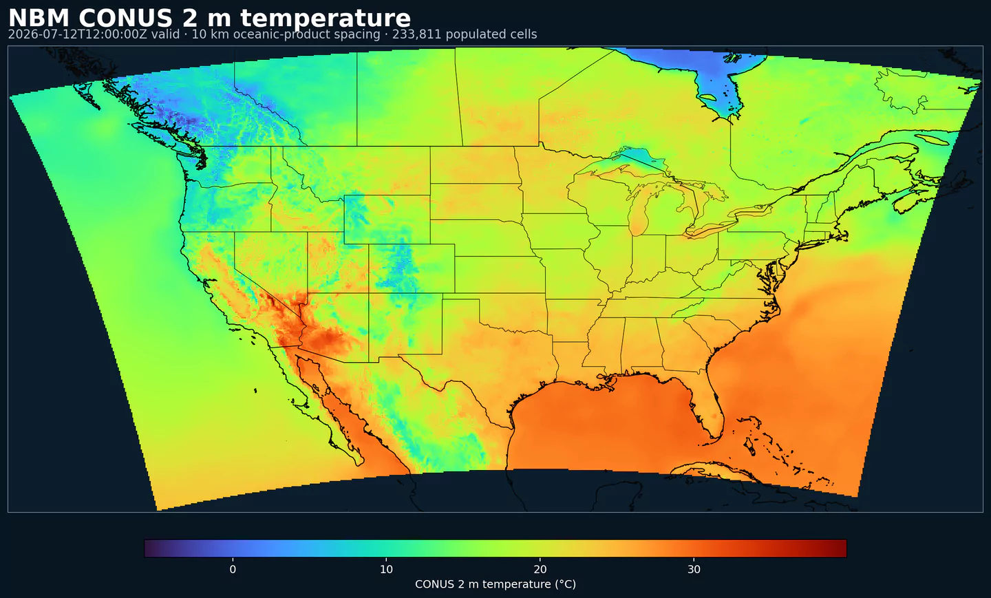
nbmparoc
Other NBM parallel core grids: nbmpar, nbmparak, nbmparhi, nbmparpr, nbmpargu
Operational counterpart: nbmoc
Deprecation note: NBM v5 is now operational in the permanent GribStream archive under nbmoc. For NBM v5 production workflows, use nbmoc; runs before 2026-05-05 12:00 UTC contain the previous operational NBM version, and runs from 2026-05-05 12:00 UTC onward use NBM v5. The nbmpar* datasets are reserved for future experimental NBM iterations if NOAA publishes them through the parallel feed.
Public NBM parallel feed on the oceanic core grid, kept separate from operational NBM Oceanic for marine validation workflows while NOAA keeps the parallel bucket available. Use nbmoc for operational NBM v5 production workflows.
The upstream bucket is noaa-nbm-para-pds. GribStream keeps the parallel feed under dedicated dataset codes so you can compare it to the operational NBM family instead of swapping existing archives underneath current workflows.
NBM v5 is more than a parameter refresh. NOAA's July 15, 2025 change notice highlights one especially visible change for API users: most hourly guidance extends from 36 hours to 48 hours, which matters if you use NBM as an hourly time series rather than just a daily summary.
NOAA also revised the blend itself, including more quantile-mapped processing for key temperature, moisture, and precipitation guidance, a percentile-picking approach for deterministic wind and gusts, higher-resolution ECMWF and Canadian inputs, and ECAIFS as a new input for several core fields. See PNS 25-45, winter configuration notes, and NBM Versions.
For the Oceanic domain, NOAA's v5 notes call out probabilistic QM bias-corrected wind speed and gust guidance, updated bias-corrected temperature, dew point, and sky-cover products, and a significant-wave-height bias correction that moves to QM and a much larger input set.
nbmoc for operational NBM v5.Click a parameter to reveal variants in a compact table with ready-to-copy JSON selectors.
Apparent temperature combines air temperature, humidity, and wind to estimate how hot or cold it feels to humans. It is useful for heat and cold stress assessments.
| Level | Info | Horizon | Introduced | Selector |
|---|---|---|---|---|
2 m above ground |
2h-264h | 5 days ago |
{"name":"APTMP","level":"2 m above ground","info":""}
|
Dew point temperature is the temperature at which the air becomes saturated. It is a direct measure of moisture content.
| Level | Info | Horizon | Introduced | Selector |
|---|---|---|---|---|
2 m above ground |
50% level |
2h-264h | 5 days ago |
{"name":"DPT","level":"2 m above ground","info":"50% level"}
|
Freezing spray indicator flags marine conditions favorable for ice accretion on vessels. It depends on wind, air temperature, and wave conditions.
| Level | Info | Horizon | Introduced | Selector |
|---|---|---|---|---|
surface |
2h-264h | 5 days ago |
{"name":"FRZSPR","level":"surface","info":""}
|
Wind gust is the peak short-duration wind speed. It captures brief, hazardous bursts that can exceed sustained winds.
| Level | Info | Horizon | Introduced | Selector |
|---|---|---|---|---|
10 m above ground |
50% level |
2h-264h | 5 days ago |
{"name":"GUST","level":"10 m above ground","info":"50% level"}
|
Precipitable water is the total column water vapor from the surface to the top of the atmosphere. It is a key moisture indicator.
| Level | Info | Horizon | Introduced | Selector |
|---|---|---|---|---|
entire atmosphere (considered as a single layer) |
1h-264h | 5 days ago |
{"name":"PWAT","level":"entire atmosphere (considered as a single layer)","info":""}
|
|
entire atmosphere (considered as a single layer) |
10% level |
1h-264h | 5 days ago |
{"name":"PWAT","level":"entire atmosphere (considered as a single layer)","info":"10% level"}
|
entire atmosphere (considered as a single layer) |
50% level |
1h-264h | 5 days ago |
{"name":"PWAT","level":"entire atmosphere (considered as a single layer)","info":"50% level"}
|
entire atmosphere (considered as a single layer) |
90% level |
1h-264h | 5 days ago |
{"name":"PWAT","level":"entire atmosphere (considered as a single layer)","info":"90% level"}
|
entire atmosphere (considered as a single layer) |
prob >12.7 |
1h-264h | 5 days ago |
{"name":"PWAT","level":"entire atmosphere (considered as a single layer)","info":"prob >12.7"}
|
entire atmosphere (considered as a single layer) |
prob >25.4 |
1h-264h | 5 days ago |
{"name":"PWAT","level":"entire atmosphere (considered as a single layer)","info":"prob >25.4"}
|
entire atmosphere (considered as a single layer) |
prob >38.1 |
1h-264h | 5 days ago |
{"name":"PWAT","level":"entire atmosphere (considered as a single layer)","info":"prob >38.1"}
|
entire atmosphere (considered as a single layer) |
prob >50.8 |
1h-264h | 5 days ago |
{"name":"PWAT","level":"entire atmosphere (considered as a single layer)","info":"prob >50.8"}
|
entire atmosphere (considered as a single layer) |
prob >63.5 |
1h-264h | 5 days ago |
{"name":"PWAT","level":"entire atmosphere (considered as a single layer)","info":"prob >63.5"}
|
Total cloud cover is the fraction of the grid cell covered by clouds at any level. It influences radiation, temperature, and visibility.
| Level | Info | Horizon | Introduced | Selector |
|---|---|---|---|---|
surface |
2h-264h | 5 days ago |
{"name":"TCDC","level":"surface","info":""}
|
|
surface |
ens std dev |
2h-264h | 5 days ago |
{"name":"TCDC","level":"surface","info":"ens std dev"}
|
Thunderstorm probability gives the chance of thunderstorms during the valid period. It is used for convective hazard guidance.
| Level | Info | Horizon | Introduced | Selector |
|---|---|---|---|---|
entire atmosphere |
1h-36h | 5 days ago |
{"name":"THUNC","level":"entire atmosphere","info":""}
|
Air temperature is the thermal state of the atmosphere at the specified level. It influences density, stability, and energy exchange.
| Level | Info | Horizon | Introduced | Selector |
|---|---|---|---|---|
2 m above ground |
50% level |
2h-264h | 5 days ago |
{"name":"TMP","level":"2 m above ground","info":"50% level"}
|
surface |
2h-264h | 5 days ago |
{"name":"TMP","level":"surface","info":""}
|
Total precipitable water transport direction is the direction of column‑integrated moisture flux. It indicates moisture transport pathways.
| Level | Info | Horizon | Introduced | Selector |
|---|---|---|---|---|
10 m above ground |
2h-167h | 5 days ago |
{"name":"TPWDIR","level":"10 m above ground","info":""}
|
Total precipitable water transport speed is the magnitude of column‑integrated moisture transport. It highlights atmospheric river strength.
| Level | Info | Horizon | Introduced | Selector |
|---|---|---|---|---|
10 m above ground |
2h-167h | 5 days ago |
{"name":"TPWSPD","level":"10 m above ground","info":""}
|
Thunderstorm indicator flags the presence of thunderstorm conditions in the grid cell. It is used as a categorical hazard field.
| Level | Info | Horizon | Introduced | Selector |
|---|---|---|---|---|
surface |
probability forecast |
1h-192h | 5 days ago |
{"name":"TSTM","level":"surface","info":"probability forecast"}
|
Horizontal visibility at the surface. Lower values indicate reduced visibility due to fog, precipitation, or aerosols.
| Level | Info | Horizon | Introduced | Selector |
|---|---|---|---|---|
surface |
50% level |
2h-264h | 5 days ago |
{"name":"VIS","level":"surface","info":"50% level"}
|
Wind direction indicates the direction from which the wind is blowing at the specified level.
| Level | Info | Horizon | Introduced | Selector |
|---|---|---|---|---|
10 m above ground |
5h-264h | 5 days ago |
{"name":"WDIR","level":"10 m above ground","info":""}
|
|
10 m above ground |
50% level |
5h-264h | 5 days ago |
{"name":"WDIR","level":"10 m above ground","info":"50% level"}
|
10 m above ground |
75% level |
5h-264h | 5 days ago |
{"name":"WDIR","level":"10 m above ground","info":"75% level"}
|
10 m above ground |
90% level |
5h-264h | 5 days ago |
{"name":"WDIR","level":"10 m above ground","info":"90% level"}
|
30 m above ground |
50% level |
5h-264h | 5 days ago |
{"name":"WDIR","level":"30 m above ground","info":"50% level"}
|
80 m above ground |
50% level |
5h-264h | 5 days ago |
{"name":"WDIR","level":"80 m above ground","info":"50% level"}
|
Wind speed is the magnitude of the horizontal wind at the specified level. It is used for transport, mixing, and hazards.
| Level | Info | Horizon | Introduced | Selector |
|---|---|---|---|---|
10 m above ground |
5h-264h | 5 days ago |
{"name":"WIND","level":"10 m above ground","info":""}
|
|
10 m above ground |
10% level |
2h-264h | 5 days ago |
{"name":"WIND","level":"10 m above ground","info":"10% level"}
|
10 m above ground |
25% level |
2h-264h | 5 days ago |
{"name":"WIND","level":"10 m above ground","info":"25% level"}
|
10 m above ground |
50% level |
2h-264h | 5 days ago |
{"name":"WIND","level":"10 m above ground","info":"50% level"}
|
10 m above ground |
75% level |
2h-264h | 5 days ago |
{"name":"WIND","level":"10 m above ground","info":"75% level"}
|
10 m above ground |
90% level |
2h-264h | 5 days ago |
{"name":"WIND","level":"10 m above ground","info":"90% level"}
|
30 m above ground |
50% level |
2h-264h | 5 days ago |
{"name":"WIND","level":"30 m above ground","info":"50% level"}
|
80 m above ground |
50% level |
2h-264h | 5 days ago |
{"name":"WIND","level":"80 m above ground","info":"50% level"}
|
No parameters match your search.