Accumulated total evapotranspiration (mm).

GribStream
GribStream Code: nwmmediumlandens
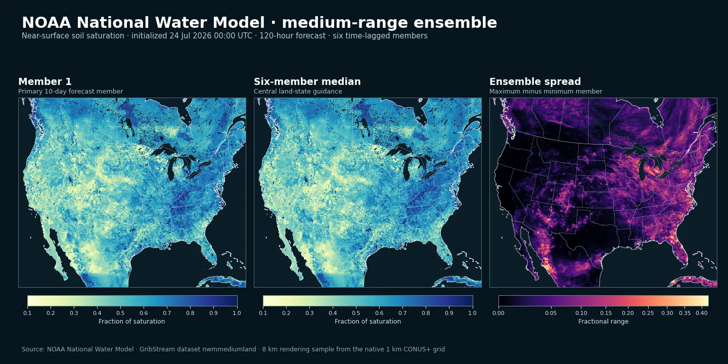
Current archive: GribStream indexes compatible source objects beginning January 1, 2025. NOAA describes the AWS source as a rolling four-week archive, so older retained objects should be treated as opportunistic rather than guaranteed permanent history.
Forecast timing: four cycles run each day. Member 1 reaches 240 hours, while members 2 through 6 reach 204 hours; all available land fields use 3-hour lead-time spacing.
Ensemble interpretation: these are six time-lagged, GFS-forced members. Their spread shows sensitivity to the forcing represented by those members; it is not by itself a calibrated probability.
Land fields only: this dataset contains the fixed 1 km land grid, not NWM's separate channel, reservoir, or terrain-routing outputs. Operational gaps and future NWM upgrades can affect availability or compatibility.
The National Water Model is NOAA's operational continental-scale hydrologic forecasting system. Its land component uses Noah-MP to represent exchanges of water and energy among soil, vegetation, snowpack, and the atmosphere.
nwmmediumlandens extends that land view into the medium range with a six-member, time-lagged ensemble forced by GFS. Users can follow each member separately or combine members to examine central guidance and spread.
All members share the same 1 km CONUS+ grid and the same six land variables. Member 1 extends to ten days; the five lagged members end at 8.5 days. The collection is therefore most directly comparable across all six members through forecast hour 204.
This is a land-state dataset rather than a streamflow product. The inventory below lists the exact selectors, levels, units, lead times, and currently indexed availability.
ACCET, FSNO, SNEQV, SNOWH, SNOWT_AVG, and SOILSAT_TOP.Click a parameter to reveal variants in a compact table with ready-to-copy JSON selectors.
Accumulated total evapotranspiration (mm).
| Level | Info | Horizon | Introduced | Selector |
|---|---|---|---|---|
land surface |
3h-240h | 2025-01-01 |
{"name":"ACCET","level":"land surface","info":""}
|
Snow-cover fraction on the ground (1).
| Level | Info | Horizon | Introduced | Selector |
|---|---|---|---|---|
ground |
3h-240h | 2025-01-01 |
{"name":"FSNO","level":"ground","info":""}
|
Snow water equivalent (kg m-2).
| Level | Info | Horizon | Introduced | Selector |
|---|---|---|---|---|
ground |
3h-240h | 2025-01-01 |
{"name":"SNEQV","level":"ground","info":""}
|
Snow depth (m).
| Level | Info | Horizon | Introduced | Selector |
|---|---|---|---|---|
ground |
3h-240h | 2025-01-01 |
{"name":"SNOWH","level":"ground","info":""}
|
Average snow temperature by layer mass (K).
| Level | Info | Horizon | Introduced | Selector |
|---|---|---|---|---|
snow column |
3h-240h | 2025-01-01 |
{"name":"SNOWT_AVG","level":"snow column","info":""}
|
Fraction of soil saturation in the top two layers (1).
| Level | Info | Horizon | Introduced | Selector |
|---|---|---|---|---|
0-0.4 m below ground |
3h-240h | 2025-01-01 |
{"name":"SOILSAT_TOP","level":"0-0.4 m below ground","info":""}
|
No parameters match your search.