Best (4-layer) lifted index uses parcels from the lowest four model layers to assess stability at 500 hPa. More negative values indicate greater instability.
- Units: K.
- Often used alongside CAPE and CIN in convective forecasting.
GribStream-Code: rrfs2dfld
Status: NOAA kennzeichnet die Echtzeit-RRFS-Daten als Prototyp vor der operativen Einführung. Die Verfügbarkeit kann daher dem experimentellen Zeitplan der Quelle folgen.
Offizielle Referenzen: NOAA RRFS AWS Open Data registry, NOAA GSL RRFS predictions overview, Unified Forecast System overview und NCEP/EMC RRFS and REFS v1 evaluation page.
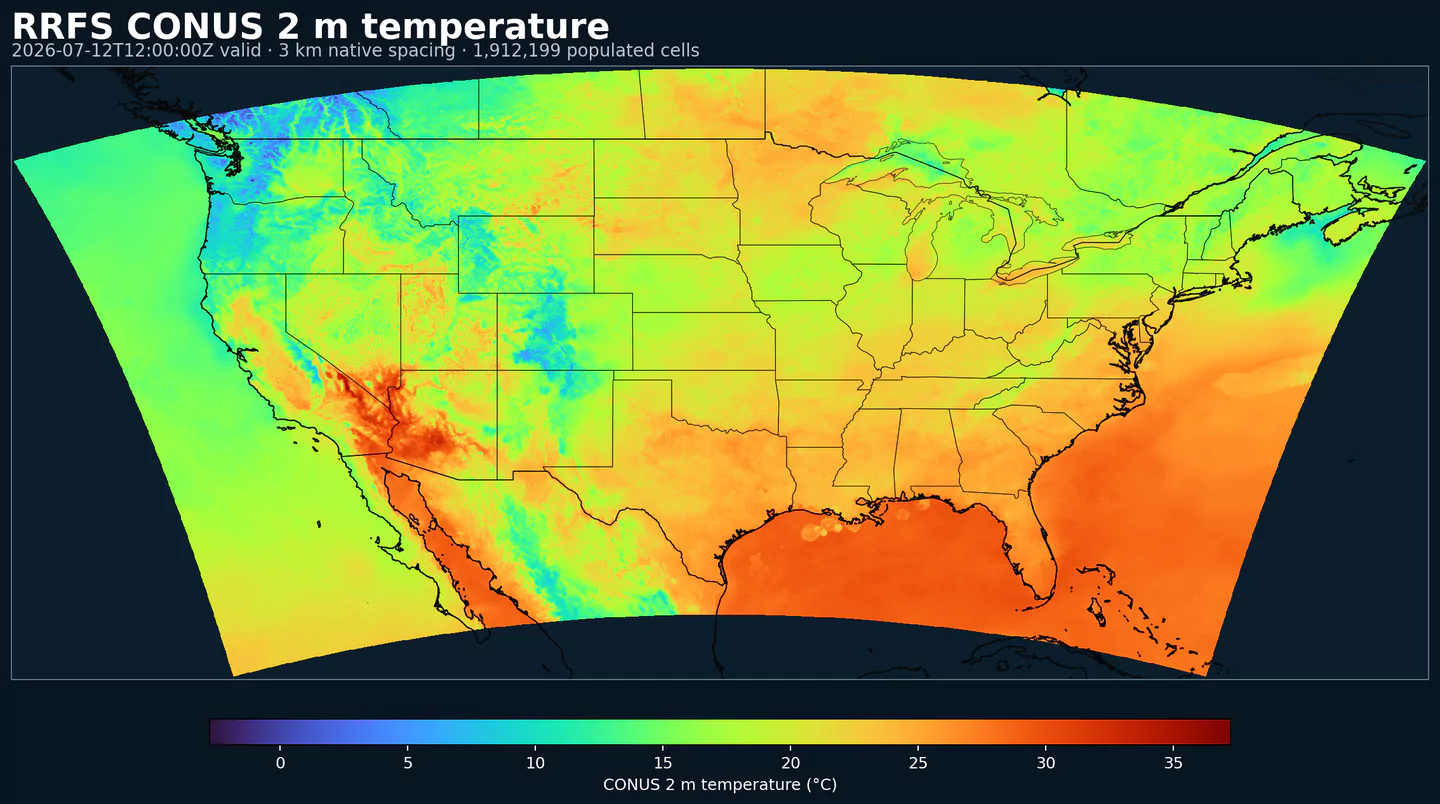
rrfs2dfld liefert die 2D-Felder des NOAA Rapid Refresh Forecast System (RRFS) auf dem CONUS-Grid.
Es ist das Oberflächen- und Diagnostik-Gegenstück zu rrfsprslev. Statt Profilen auf Druckleveln bündelt es endanwendungsnahe Variablen: Wind, Temperatur, Niederschlag, Wolken, Strahlung, Boden und Gewitterindikatoren.
RRFS gehört zur regionalen nächsten Generation von NOAA und basiert auf dem Unified Forecast System (UFS), mit gemeinsamen Komponenten für Physik, Datenassimilation, Preprocessing, Postprocessing und Verifikation.
Diese Seite ist meist der erste RRFS-Startpunkt, wenn Ihr Anwendungsfall Punktabfragen, Energie, Luftfahrt, Transport, Starkregen, Schnee, Oberflächenwind, Sichtweite oder Bodenvariablen über CONUS benötigt.
Die Quelle bleibt in einer Phase vor der operativen Einführung, daher kann sich der verfügbare Feldumfang weiter ändern. In GribStream sind die Katalogselektoren name, level und info die stabile Referenz für Abfragen und Integrationen.
Für GribStream-Kunden ist rrfs2dfld die direkteste RRFS-Option, wenn ein Produkt 3-km-Oberflächenfelder im Kurzfristbereich mit demselben API-Muster wie der restliche Katalog benötigt.
rrfsprslev: Nutzen Sie rrfs2dfld für endanwendungsnahe Variablen und rrfsprslev für Struktur in der Höhe.Klicken Sie auf einen Parameter, um Varianten in einer kompakten Tabelle mit kopierbaren JSON-Selektoren zu sehen. Codes, Levels und Selector-Werte bleiben exakt so, wie die API sie ausgibt.
Best (4-layer) lifted index uses parcels from the lowest four model layers to assess stability at 500 hPa. More negative values indicate greater instability.
| Level | Info | Horizon | Introduced | Selector |
|---|---|---|---|---|
180-0 mb above ground |
0h-84h | 15 days ago |
{"name":"4LFTX","level":"180-0 mb above ground","info":""}
|
Aerosol emission flux represents the rate at which aerosols are emitted into the atmosphere from the surface. It reflects source strength from dust, smoke, and other particulates.
| Level | Info | Horizon | Introduced | Selector |
|---|---|---|---|---|
entire atmosphere (considered as a single layer) |
aerosol=Dust dry |
0h-84h | 15 days ago |
{"name":"AEMFLX","level":"entire atmosphere (considered as a single layer)","info":"aerosol=Dust dry"}
|
entire atmosphere (considered as a single layer) |
aerosol=Particulate organic matter dry |
0h-84h | 15 days ago |
{"name":"AEMFLX","level":"entire atmosphere (considered as a single layer)","info":"aerosol=Particulate organic matter dry"}
|
Surface albedo is the fraction of incoming shortwave radiation reflected by the surface. Higher albedo means less solar energy absorbed and a cooler surface.
| Level | Info | Horizon | Introduced | Selector |
|---|---|---|---|---|
surface |
0h-84h | 15 days ago |
{"name":"ALBDO","level":"surface","info":""}
|
Aerosol optical thickness represents the column-integrated attenuation of solar radiation by aerosols. Larger values indicate hazier conditions and reduced surface sunlight.
| Level | Info | Horizon | Introduced | Selector |
|---|---|---|---|---|
entire atmosphere (considered as a single layer) |
0h-84h | 15 days ago |
{"name":"AOTK","level":"entire atmosphere (considered as a single layer)","info":""}
|
Accumulated precipitation represents the total water-equivalent amount of rain and snow during the output period. It is a primary field for hydrologic impacts and event totals.
| Level | Info | Horizon | Introduced | Selector |
|---|---|---|---|---|
surface |
1h-84h | 15 days ago |
{"name":"APCP","level":"surface","info":""}
|
Accumulated snow depth is the total depth of snow on the ground over the period. It is a physical depth, not water equivalent.
| Level | Info | Horizon | Introduced | Selector |
|---|---|---|---|---|
surface |
1h-84h | 15 days ago |
{"name":"ASNOW","level":"surface","info":""}
|
Brightness Temperature (K).
| Level | Info | Horizon | Introduced | Selector |
|---|---|---|---|---|
top of atmosphere |
0h-84h | 15 days ago |
{"name":"BRTEMP","level":"top of atmosphere","info":""}
|
Critical Angle (degree).
| Level | Info | Horizon | Introduced | Selector |
|---|---|---|---|---|
0-500 m above ground |
0h-84h | 15 days ago |
{"name":"CANGLE","level":"0-500 m above ground","info":""}
|
Convective Available Potential Energy (CAPE) quantifies buoyant energy available to rising air parcels. Larger values generally imply stronger potential updrafts and greater convective intensity.
| Level | Info | Horizon | Introduced | Selector |
|---|---|---|---|---|
0-3000 m above ground |
0h-84h | 15 days ago |
{"name":"CAPE","level":"0-3000 m above ground","info":""}
|
|
180-0 mb above ground |
0h-84h | 15 days ago |
{"name":"CAPE","level":"180-0 mb above ground","info":""}
|
|
255-0 mb above ground |
0h-84h | 15 days ago |
{"name":"CAPE","level":"255-0 mb above ground","info":""}
|
|
90-0 mb above ground |
0h-84h | 15 days ago |
{"name":"CAPE","level":"90-0 mb above ground","info":""}
|
|
surface |
0h-84h | 15 days ago |
{"name":"CAPE","level":"surface","info":""}
|
Drag coefficient represents the aerodynamic resistance between the surface and the atmosphere. It controls surface stress and is used in momentum and heat flux calculations.
| Level | Info | Horizon | Introduced | Selector |
|---|---|---|---|---|
surface |
0h-84h | 15 days ago |
{"name":"CD","level":"surface","info":""}
|
Ceiling height is the altitude of the lowest cloud base that covers a significant portion of the sky. It is a key aviation and surface-visibility metric.
| Level | Info | Horizon | Introduced | Selector |
|---|---|---|---|---|
cloud ceiling |
0h-84h | 15 days ago |
{"name":"CEIL","level":"cloud ceiling","info":""}
|
Categorical indicator of freezing rain occurrence at the surface during the output period.
| Level | Info | Horizon | Introduced | Selector |
|---|---|---|---|---|
surface |
0h-84h | 15 days ago |
{"name":"CFRZR","level":"surface","info":""}
|
Categorical indicator of ice pellet (sleet) occurrence at the surface during the output period.
| Level | Info | Horizon | Introduced | Selector |
|---|---|---|---|---|
surface |
0h-84h | 15 days ago |
{"name":"CICEP","level":"surface","info":""}
|
Convective Inhibition (CIN) measures the energy barrier that must be overcome to initiate convection. More negative values indicate a stronger cap that can suppress storms.
| Level | Info | Horizon | Introduced | Selector |
|---|---|---|---|---|
180-0 mb above ground |
0h-84h | 15 days ago |
{"name":"CIN","level":"180-0 mb above ground","info":""}
|
|
255-0 mb above ground |
0h-84h | 15 days ago |
{"name":"CIN","level":"255-0 mb above ground","info":""}
|
|
90-0 mb above ground |
0h-84h | 15 days ago |
{"name":"CIN","level":"90-0 mb above ground","info":""}
|
|
surface |
0h-84h | 15 days ago |
{"name":"CIN","level":"surface","info":""}
|
Column-integrated soil moisture is the vertically integrated amount of water stored in the soil column.
| Level | Info | Horizon | Introduced | Selector |
|---|---|---|---|---|
0 m underground |
0h-84h | 15 days ago |
{"name":"CISOILM","level":"0 m underground","info":""}
|
Plant canopy surface water is liquid water intercepted by vegetation. It represents interception storage and evaporation potential.
| Level | Info | Horizon | Introduced | Selector |
|---|---|---|---|---|
surface |
0h-84h | 15 days ago |
{"name":"CNWAT","level":"surface","info":""}
|
Column-integrated mass density is the total mass per unit area through the vertical column for the specified species. It summarizes column burden and is useful for transport diagnostics.
| Level | Info | Horizon | Introduced | Selector |
|---|---|---|---|---|
entire atmosphere (considered as a single layer) |
aerosol=Dust dry |
0h-84h | 15 days ago |
{"name":"COLMD","level":"entire atmosphere (considered as a single layer)","info":"aerosol=Dust dry"}
|
entire atmosphere (considered as a single layer) |
aerosol=Particulate organic matter dry |
0h-84h | 15 days ago |
{"name":"COLMD","level":"entire atmosphere (considered as a single layer)","info":"aerosol=Particulate organic matter dry"}
|
Percent frozen precipitation indicates the fraction of total precipitation that is falling in frozen form. It helps distinguish mixed-phase and winter precipitation impacts.
| Level | Info | Horizon | Introduced | Selector |
|---|---|---|---|---|
surface |
0h-84h | 15 days ago |
{"name":"CPOFP","level":"surface","info":""}
|
Categorical indicator of rain occurrence at the surface during the output period. Useful as a yes/no mask for rain.
| Level | Info | Horizon | Introduced | Selector |
|---|---|---|---|---|
surface |
0h-84h | 15 days ago |
{"name":"CRAIN","level":"surface","info":""}
|
Clear‑sky downward shortwave flux is broadband solar energy at the surface without cloud effects.
| Level | Info | Horizon | Introduced | Selector |
|---|---|---|---|---|
surface |
0h-84h | 15 days ago |
{"name":"CSDSF","level":"surface","info":""}
|
Categorical indicator of snow occurrence at the surface during the output period.
| Level | Info | Horizon | Introduced | Selector |
|---|---|---|---|---|
surface |
0h-84h | 15 days ago |
{"name":"CSNOW","level":"surface","info":""}
|
Downdraft Convective Available Potential Energy (J/kg).
| Level | Info | Horizon | Introduced | Selector |
|---|---|---|---|---|
400-0 mb above ground |
0h-84h | 15 days ago |
{"name":"DCAPE","level":"400-0 mb above ground","info":""}
|
Dew point depression is the difference between air temperature and dew point. Small values indicate near‑saturation.
| Level | Info | Horizon | Introduced | Selector |
|---|---|---|---|---|
2 m above ground |
0h-84h | 15 days ago |
{"name":"DEPR","level":"2 m above ground","info":""}
|
Downward longwave (thermal) flux represents incoming energy at the surface. It is a key driver of surface heating and cooling.
| Level | Info | Horizon | Introduced | Selector |
|---|---|---|---|---|
surface |
0h-84h | 15 days ago |
{"name":"DLWRF","level":"surface","info":""}
|
Dew point temperature is the temperature at which the air becomes saturated. It is a direct measure of moisture content.
| Level | Info | Horizon | Introduced | Selector |
|---|---|---|---|---|
2 m above ground |
0h-84h | 15 days ago |
{"name":"DPT","level":"2 m above ground","info":""}
|
Downward radiative flux represents incoming energy at the surface. It is a key driver of surface heating and cooling.
| Level | Info | Horizon | Introduced | Selector |
|---|---|---|---|---|
surface |
0h-84h | 15 days ago |
{"name":"DSWRF","level":"surface","info":""}
|
Effective Storm Relative Helicity (m2 s-2).
| Level | Info | Horizon | Introduced | Selector |
|---|---|---|---|---|
surface |
0h-84h | 15 days ago |
{"name":"EFHL","level":"surface","info":""}
|
Equilibrium Level Melting Potential (K).
| Level | Info | Horizon | Introduced | Selector |
|---|---|---|---|---|
equilibrium level |
0h-84h | 15 days ago |
{"name":"ELMELT","level":"equilibrium level","info":""}
|
East longitude gives the longitude position of the grid point in degrees east. It is a static geographic coordinate field.
| Level | Info | Horizon | Introduced | Selector |
|---|---|---|---|---|
surface |
0h-84h | 15 days ago |
{"name":"ELON","level":"surface","info":""}
|
Fire Radiative Power (W).
| Level | Info | Horizon | Introduced | Selector |
|---|---|---|---|---|
surface |
0h-84h | 15 days ago |
{"name":"FRADPOW","level":"surface","info":""}
|
Friction velocity (u*) is a measure of near‑surface shear stress. It is commonly used in turbulence, dust, and air‑sea exchange calculations.
| Level | Info | Horizon | Introduced | Selector |
|---|---|---|---|---|
surface |
0h-84h | 15 days ago |
{"name":"FRICV","level":"surface","info":""}
|
Freezing rain accumulation is the water-equivalent amount of freezing rain during the period. It relates directly to ice accretion risk.
| Level | Info | Horizon | Introduced | Selector |
|---|---|---|---|---|
surface |
1h-84h | 15 days ago |
{"name":"FROZR","level":"surface","info":""}
|
Freezing rain accumulation is the water-equivalent amount of freezing rain during the period. It relates directly to ice accretion risk.
| Level | Info | Horizon | Introduced | Selector |
|---|---|---|---|---|
surface |
1h-84h | 15 days ago |
{"name":"FRZR","level":"surface","info":""}
|
Ground heat flux is the conductive heat exchange between the surface and the subsurface. It is a key term in the surface energy balance.
| Level | Info | Horizon | Introduced | Selector |
|---|---|---|---|---|
surface |
0h-84h | 15 days ago |
{"name":"GFLUX","level":"surface","info":""}
|
Wind gust is the peak short-duration wind speed. It captures brief, hazardous bursts that can exceed sustained winds.
| Level | Info | Horizon | Introduced | Selector |
|---|---|---|---|---|
surface |
0h-84h | 15 days ago |
{"name":"GUST","level":"surface","info":""}
|
Hail represents hail size as a length measure. Larger values indicate more severe hail potential.
| Level | Info | Horizon | Introduced | Selector |
|---|---|---|---|---|
surface |
1h-84h | 15 days ago |
{"name":"HAIL","level":"surface","info":""}
|
High cloud cover is the fraction of the grid cell covered by clouds in the upper troposphere. It affects longwave radiation and aviation.
| Level | Info | Horizon | Introduced | Selector |
|---|---|---|---|---|
high cloud layer |
0h-84h | 15 days ago |
{"name":"HCDC","level":"high cloud layer","info":""}
|
Geopotential height is the altitude of a pressure surface in the atmosphere. It is the primary field for identifying ridges, troughs, and large‑scale flow patterns.
| Level | Info | Horizon | Introduced | Selector |
|---|---|---|---|---|
0C isotherm |
0h-84h | 15 days ago |
{"name":"HGT","level":"0C isotherm","info":""}
|
|
253 K level |
0h-84h | 15 days ago |
{"name":"HGT","level":"253 K level","info":""}
|
|
cloud base |
0h-84h | 15 days ago |
{"name":"HGT","level":"cloud base","info":""}
|
|
cloud ceiling |
0h-84h | 15 days ago |
{"name":"HGT","level":"cloud ceiling","info":""}
|
|
cloud top |
0h-84h | 15 days ago |
{"name":"HGT","level":"cloud top","info":""}
|
|
equilibrium level |
0h-84h | 15 days ago |
{"name":"HGT","level":"equilibrium level","info":""}
|
|
highest top level of supercooled liquid water layer |
0h-84h | 15 days ago |
{"name":"HGT","level":"highest top level of supercooled liquid water layer","info":""}
|
|
highest tropospheric freezing level |
0h-84h | 15 days ago |
{"name":"HGT","level":"highest tropospheric freezing level","info":""}
|
|
level of adiabatic condensation from sfc |
0h-84h | 15 days ago |
{"name":"HGT","level":"level of adiabatic condensation from sfc","info":""}
|
|
lowest bottom level of supercooled liquid water layer |
0h-84h | 15 days ago |
{"name":"HGT","level":"lowest bottom level of supercooled liquid water layer","info":""}
|
|
lowest level of the wet bulb zero |
0h-84h | 15 days ago |
{"name":"HGT","level":"lowest level of the wet bulb zero","info":""}
|
|
max wind |
0h-84h | 15 days ago |
{"name":"HGT","level":"max wind","info":""}
|
|
surface |
0h-84h | 15 days ago |
{"name":"HGT","level":"surface","info":""}
|
|
tropopause |
0h-84h | 15 days ago |
{"name":"HGT","level":"tropopause","info":""}
|
Mass Density Height (m).
| Level | Info | Horizon | Introduced | Selector |
|---|---|---|---|---|
entire atmosphere (considered as a single layer) |
0h-84h | 15 days ago |
{"name":"HGTMD","level":"entire atmosphere (considered as a single layer)","info":""}
|
|
highest level > 1e-09 kg/m^3 |
0h-84h | 15 days ago |
{"name":"HGTMD","level":"highest level > 1e-09 kg/m^3","info":""}
|
|
lowest level > 1e-09 kg/m^3 |
0h-84h | 15 days ago |
{"name":"HGTMD","level":"lowest level > 1e-09 kg/m^3","info":""}
|
Storm-relative helicity measures the potential for streamwise vorticity to be ingested by a storm updraft. Higher values suggest a greater likelihood of rotating updrafts.
| Level | Info | Horizon | Introduced | Selector |
|---|---|---|---|---|
1000-0 m above ground |
0h-84h | 15 days ago |
{"name":"HLCY","level":"1000-0 m above ground","info":""}
|
|
3000-0 m above ground |
0h-84h | 15 days ago |
{"name":"HLCY","level":"3000-0 m above ground","info":""}
|
Boundary layer height marks the depth of the turbulent surface-influenced layer. It affects mixing, dispersion, and surface fluxes.
| Level | Info | Horizon | Introduced | Selector |
|---|---|---|---|---|
surface |
0h-84h | 15 days ago |
{"name":"HPBL","level":"surface","info":""}
|
Ice cover is the proportion of the grid cell covered by ice. It is used as a surface-state mask for sea ice and related cryosphere diagnostics.
| Level | Info | Horizon | Introduced | Selector |
|---|---|---|---|---|
surface |
0h-84h | 15 days ago |
{"name":"ICEC","level":"surface","info":""}
|
Ice growth rate represents the rate of sea-ice thickness increase. It reflects freezing conditions at the surface and in the upper ocean.
| Level | Info | Horizon | Introduced | Selector |
|---|---|---|---|---|
10 m above mean sea level |
0h-84h | 15 days ago |
{"name":"ICEG","level":"10 m above mean sea level","info":""}
|
Leaf Area Index (dimensionless).
| Level | Info | Horizon | Introduced | Selector |
|---|---|---|---|---|
surface |
0h-84h | 15 days ago |
{"name":"LAI","level":"surface","info":""}
|
Land cover is a land/sea mask where 0 indicates sea and 1 indicates land. It is used to separate land and ocean surface processes.
| Level | Info | Horizon | Introduced | Selector |
|---|---|---|---|---|
surface |
0h-84h | 15 days ago |
{"name":"LAND","level":"surface","info":""}
|
Layer thickness is the vertical distance between the bounds of a layer. It helps interpret thermodynamic and lifted-layer diagnostics.
| Level | Info | Horizon | Introduced | Selector |
|---|---|---|---|---|
261 K level - 256 K level |
0h-84h | 15 days ago |
{"name":"LAYTH","level":"261 K level - 256 K level","info":""}
|
Low cloud cover is the fraction of the grid cell covered by low clouds. It strongly affects visibility, fog potential, and surface temperatures.
| Level | Info | Horizon | Introduced | Selector |
|---|---|---|---|---|
low cloud layer |
0h-84h | 15 days ago |
{"name":"LCDC","level":"low cloud layer","info":""}
|
Lifted Index compares a lifted parcel's temperature to the environment at 500 hPa. More negative values indicate greater instability and thunderstorm potential.
| Level | Info | Horizon | Introduced | Selector |
|---|---|---|---|---|
500-1000 mb |
0h-84h | 15 days ago |
{"name":"LFTX","level":"500-1000 mb","info":""}
|
Latent heat net flux represents energy exchange due to evaporation/condensation at the surface. It links moisture and energy budgets.
| Level | Info | Horizon | Introduced | Selector |
|---|---|---|---|---|
surface |
0h-84h | 15 days ago |
{"name":"LHTFL","level":"surface","info":""}
|
Mass-Point Land Mask (flag).
| Level | Info | Horizon | Introduced | Selector |
|---|---|---|---|---|
surface |
0h-84h | 15 days ago |
{"name":"LMH","level":"surface","info":""}
|
Velocity-Point Land Mask (flag).
| Level | Info | Horizon | Introduced | Selector |
|---|---|---|---|---|
surface |
0h-84h | 15 days ago |
{"name":"LMV","level":"surface","info":""}
|
Lightning is a dimensionless model diagnostic in these NOAA mesoscale inventories. Higher values indicate greater modeled lightning or convective electrical activity.
| Level | Info | Horizon | Introduced | Selector |
|---|---|---|---|---|
entire atmosphere |
1h-84h | 15 days ago |
{"name":"LTNG","level":"entire atmosphere","info":""}
|
Lightning Strike Density (flashes km-2).
| Level | Info | Horizon | Introduced | Selector |
|---|---|---|---|---|
1 m above ground |
1h-84h | 15 days ago |
{"name":"LTNGSD","level":"1 m above ground","info":""}
|
|
2 m above ground |
1h-84h | 15 days ago |
{"name":"LTNGSD","level":"2 m above ground","info":""}
|
Mass density (concentration) represents mass per unit volume of the named species or medium. It is used for concentration and transport analyses.
| Level | Info | Horizon | Introduced | Selector |
|---|---|---|---|---|
8 m above ground |
aerosol=Dust dry |
0h-84h | 15 days ago |
{"name":"MASSDEN","level":"8 m above ground","info":"aerosol=Dust dry"}
|
8 m above ground |
aerosol=Particulate organic matter dry |
0h-84h | 15 days ago |
{"name":"MASSDEN","level":"8 m above ground","info":"aerosol=Particulate organic matter dry"}
|
8 m above ground |
aerosol=Total aerosol |
1h-84h | 15 days ago |
{"name":"MASSDEN","level":"8 m above ground","info":"aerosol=Total aerosol"}
|
Hourly maximum downward vertical velocity in the lowest 400 hPa highlights the strongest subsidence within the lower troposphere during the hour.
| Level | Info | Horizon | Introduced | Selector |
|---|---|---|---|---|
100-1000 mb |
1h-84h | 15 days ago |
{"name":"MAXDVV","level":"100-1000 mb","info":""}
|
Hourly maximum simulated reflectivity at 1 km AGL captures the strongest modeled reflectivity near the surface. It is used to identify peak convective intensity and heavy precipitation cores.
| Level | Info | Horizon | Introduced | Selector |
|---|---|---|---|---|
1000 m above ground |
1h-84h | 15 days ago |
{"name":"MAXREF","level":"1000 m above ground","info":""}
|
|
263 K level |
1h-84h | 15 days ago |
{"name":"MAXREF","level":"263 K level","info":""}
|
Maximum relative humidity is the highest RH reached during the period. It can indicate peak cloud or fog potential.
| Level | Info | Horizon | Introduced | Selector |
|---|---|---|---|---|
2 m above ground |
1h-84h | 15 days ago |
{"name":"MAXRH","level":"2 m above ground","info":""}
|
Hourly maximum upward vertical velocity in the lowest 400 hPa highlights the strongest updrafts within the lower troposphere during the hour.
| Level | Info | Horizon | Introduced | Selector |
|---|---|---|---|---|
100-1000 mb |
1h-84h | 15 days ago |
{"name":"MAXUVV","level":"100-1000 mb","info":""}
|
Maximum u‑component of wind is the strongest east‑west flow during the period. It helps identify peak wind directions.
| Level | Info | Horizon | Introduced | Selector |
|---|---|---|---|---|
10 m above ground |
1h-84h | 15 days ago |
{"name":"MAXUW","level":"10 m above ground","info":""}
|
Maximum v‑component of wind is the strongest north‑south flow during the period.
| Level | Info | Horizon | Introduced | Selector |
|---|---|---|---|---|
10 m above ground |
1h-84h | 15 days ago |
{"name":"MAXVW","level":"10 m above ground","info":""}
|
Mid-level cloud cover is the fraction of the grid cell covered by clouds in the middle troposphere. It influences both shortwave and longwave radiation.
| Level | Info | Horizon | Introduced | Selector |
|---|---|---|---|---|
middle cloud layer |
0h-84h | 15 days ago |
{"name":"MCDC","level":"middle cloud layer","info":""}
|
Moisture convergence is the horizontal convergence of water vapor transport. Areas of convergence favor rising motion and precipitation development.
| Level | Info | Horizon | Introduced | Selector |
|---|---|---|---|---|
entire atmosphere (considered as a single layer) |
0h-84h | 15 days ago |
{"name":"MCONV","level":"entire atmosphere (considered as a single layer)","info":""}
|
Minimum relative humidity is the lowest RH reached during the period. It is used in fire‑weather and drying assessments.
| Level | Info | Horizon | Introduced | Selector |
|---|---|---|---|---|
2 m above ground |
1h-84h | 15 days ago |
{"name":"MINRH","level":"2 m above ground","info":""}
|
Hourly minimum updraft helicity is the lowest helicity value during the hour. It provides a lower bound on rotating updraft potential.
| Level | Info | Horizon | Introduced | Selector |
|---|---|---|---|---|
3000-0 m above ground |
1h-84h | 15 days ago |
{"name":"MNUPHL","level":"3000-0 m above ground","info":""}
|
|
5000-2000 m above ground |
1h-84h | 15 days ago |
{"name":"MNUPHL","level":"5000-2000 m above ground","info":""}
|
Mean sea level pressure (ETA reduction) is MSLP computed using the ETA model reduction method. It is used for synoptic analysis.
| Level | Info | Horizon | Introduced | Selector |
|---|---|---|---|---|
mean sea level |
0h-84h | 15 days ago |
{"name":"MSLET","level":"mean sea level","info":""}
|
Moisture availability represents how much moisture is available at the surface for evaporation. It is used in land-surface and fire-weather diagnostics.
| Level | Info | Horizon | Introduced | Selector |
|---|---|---|---|---|
0 m underground |
0h-84h | 15 days ago |
{"name":"MSTAV","level":"0 m underground","info":""}
|
Maximum snow albedo is the highest reflectivity of the snow surface during the period. Higher values indicate fresher, brighter snow.
| Level | Info | Horizon | Introduced | Selector |
|---|---|---|---|---|
surface |
0h-84h | 15 days ago |
{"name":"MXSALB","level":"surface","info":""}
|
Hourly maximum updraft helicity (2–5 km AGL) highlights the strongest rotating updrafts during the hour.
| Level | Info | Horizon | Introduced | Selector |
|---|---|---|---|---|
3000-0 m above ground |
1h-84h | 15 days ago |
{"name":"MXUPHL","level":"3000-0 m above ground","info":""}
|
|
5000-2000 m above ground |
1h-84h | 15 days ago |
{"name":"MXUPHL","level":"5000-2000 m above ground","info":""}
|
North latitude gives the latitude position of the grid point in degrees north. It is a static geographic coordinate field.
| Level | Info | Horizon | Introduced | Selector |
|---|---|---|---|---|
surface |
0h-84h | 15 days ago |
{"name":"NLAT","level":"surface","info":""}
|
Potential evaporation is the amount of water that could evaporate if sufficient moisture were available. It reflects atmospheric demand.
| Level | Info | Horizon | Introduced | Selector |
|---|---|---|---|---|
surface |
1h-84h | 15 days ago |
{"name":"PEVAP","level":"surface","info":""}
|
Potential evaporation rate is the potential latent heat flux for evaporation under an assumed unlimited water supply.
| Level | Info | Horizon | Introduced | Selector |
|---|---|---|---|---|
surface |
0h-84h | 15 days ago |
{"name":"PEVPR","level":"surface","info":""}
|
Pressure of the level from which the parcel was lifted indicates the parcel source level used for stability indices. It helps interpret lifted index and CAPE products.
| Level | Info | Horizon | Introduced | Selector |
|---|---|---|---|---|
255-0 mb above ground |
0h-84h | 15 days ago |
{"name":"PLPL","level":"255-0 mb above ground","info":""}
|
Soil porosity is the fraction of soil volume that is pore space. It governs storage and drainage capacity.
| Level | Info | Horizon | Introduced | Selector |
|---|---|---|---|---|
surface |
0h-84h | 15 days ago |
{"name":"POROS","level":"surface","info":""}
|
Potential temperature is the temperature a parcel would have if brought dry‑adiabatically to a reference pressure. It is used for stability.
| Level | Info | Horizon | Introduced | Selector |
|---|---|---|---|---|
surface |
0h-84h | 15 days ago |
{"name":"POT","level":"surface","info":""}
|
|
tropopause |
0h-84h | 15 days ago |
{"name":"POT","level":"tropopause","info":""}
|
Precipitation rate is the total intensity of precipitation over the period. It combines convective and stratiform contributions.
| Level | Info | Horizon | Introduced | Selector |
|---|---|---|---|---|
surface |
0h-84h | 15 days ago |
{"name":"PRATE","level":"surface","info":""}
|
Pressure is the atmospheric pressure at the specified level. It is a fundamental mass-field variable for dynamics and thermodynamics.
| Level | Info | Horizon | Introduced | Selector |
|---|---|---|---|---|
0C isotherm |
0h-84h | 15 days ago |
{"name":"PRES","level":"0C isotherm","info":""}
|
|
80 m above ground |
0h-84h | 15 days ago |
{"name":"PRES","level":"80 m above ground","info":""}
|
|
cloud base |
0h-84h | 15 days ago |
{"name":"PRES","level":"cloud base","info":""}
|
|
cloud top |
0h-84h | 15 days ago |
{"name":"PRES","level":"cloud top","info":""}
|
|
grid scale cloud bottom level |
0h-84h | 15 days ago |
{"name":"PRES","level":"grid scale cloud bottom level","info":""}
|
|
grid scale cloud top level |
0h-84h | 15 days ago |
{"name":"PRES","level":"grid scale cloud top level","info":""}
|
|
highest tropospheric freezing level |
0h-84h | 15 days ago |
{"name":"PRES","level":"highest tropospheric freezing level","info":""}
|
|
level of adiabatic condensation from sfc |
0h-84h | 15 days ago |
{"name":"PRES","level":"level of adiabatic condensation from sfc","info":""}
|
|
max wind |
0h-84h | 15 days ago |
{"name":"PRES","level":"max wind","info":""}
|
|
surface |
0h-84h | 15 days ago |
{"name":"PRES","level":"surface","info":""}
|
|
top of atmosphere |
0h-84h | 15 days ago |
{"name":"PRES","level":"top of atmosphere","info":""}
|
|
tropopause |
0h-84h | 15 days ago |
{"name":"PRES","level":"tropopause","info":""}
|
Precipitable water is the total column water vapor from the surface to the top of the atmosphere. It is a key moisture indicator.
| Level | Info | Horizon | Introduced | Selector |
|---|---|---|---|---|
entire atmosphere (considered as a single layer) |
0h-84h | 15 days ago |
{"name":"PWAT","level":"entire atmosphere (considered as a single layer)","info":""}
|
Quantitative Precipitation Forecast Average Recurrence Interval (year).
| Level | Info | Horizon | Introduced | Selector |
|---|---|---|---|---|
surface |
prob >10 |
1h-84h | 15 days ago |
{"name":"QPFARI","level":"surface","info":"prob >10"}
|
surface |
prob >100 |
1h-84h | 15 days ago |
{"name":"QPFARI","level":"surface","info":"prob >100"}
|
surface |
prob >2 |
1h-84h | 15 days ago |
{"name":"QPFARI","level":"surface","info":"prob >2"}
|
surface |
prob >5 |
1h-84h | 15 days ago |
{"name":"QPFARI","level":"surface","info":"prob >5"}
|
Quantitative Precipitation Forecast Relative to Flash Flood Guidance (%).
| Level | Info | Horizon | Introduced | Selector |
|---|---|---|---|---|
surface |
prob >1 |
1h-84h | 15 days ago |
{"name":"QPFFFG","level":"surface","info":"prob >1"}
|
Composite reflectivity is the maximum reflectivity in the column. It is a standard radar‑style field for identifying convective cores and precipitation intensity.
| Level | Info | Horizon | Introduced | Selector |
|---|---|---|---|---|
entire atmosphere (considered as a single layer) |
0h-84h | 15 days ago |
{"name":"REFC","level":"entire atmosphere (considered as a single layer)","info":""}
|
Reflectivity is a radar‑style measure of hydrometeor concentration at a given level. Higher values generally correspond to heavier precipitation.
| Level | Info | Horizon | Introduced | Selector |
|---|---|---|---|---|
1000 m above ground |
0h-84h | 15 days ago |
{"name":"REFD","level":"1000 m above ground","info":""}
|
|
263 K level |
0h-84h | 15 days ago |
{"name":"REFD","level":"263 K level","info":""}
|
|
4000 m above ground |
0h-84h | 15 days ago |
{"name":"REFD","level":"4000 m above ground","info":""}
|
Relative vorticity measures local rotation of the horizontal wind field. Positive values indicate cyclonic rotation and negative values anticyclonic rotation.
| Level | Info | Horizon | Introduced | Selector |
|---|---|---|---|---|
1 hybrid level |
1h-84h | 15 days ago |
{"name":"RELV","level":"1 hybrid level","info":""}
|
|
1000-0 m above ground |
1h-84h | 15 days ago |
{"name":"RELV","level":"1000-0 m above ground","info":""}
|
|
2000-0 m above ground |
1h-84h | 15 days ago |
{"name":"RELV","level":"2000-0 m above ground","info":""}
|
Echo top height is the altitude of the highest reflectivity in the column. It is a proxy for storm depth and convective vigor.
| Level | Info | Horizon | Introduced | Selector |
|---|---|---|---|---|
entire atmosphere (considered as a single layer) |
0h-84h | 15 days ago |
{"name":"RETOP","level":"entire atmosphere (considered as a single layer)","info":""}
|
Relative humidity describes how close the air is to saturation at the specified level. High values favor cloud formation.
| Level | Info | Horizon | Introduced | Selector |
|---|---|---|---|---|
0C isotherm |
0h-84h | 15 days ago |
{"name":"RH","level":"0C isotherm","info":""}
|
|
2 m above ground |
0h-84h | 15 days ago |
{"name":"RH","level":"2 m above ground","info":""}
|
|
highest tropospheric freezing level |
0h-84h | 15 days ago |
{"name":"RH","level":"highest tropospheric freezing level","info":""}
|
Relative humidity with respect to precipitable water is a column‑scale moisture indicator based on total water vapor content.
| Level | Info | Horizon | Introduced | Selector |
|---|---|---|---|---|
entire atmosphere |
0h-84h | 15 days ago |
{"name":"RHPW","level":"entire atmosphere","info":""}
|
Number of soil layers is a static model metadata field describing the soil discretization.
| Level | Info | Horizon | Introduced | Selector |
|---|---|---|---|---|
surface |
0h-84h | 15 days ago |
{"name":"RLYRS","level":"surface","info":""}
|
Minimum stomatal resistance is a vegetation parameter controlling transpiration efficiency. Lower values allow stronger evapotranspiration under favorable conditions.
| Level | Info | Horizon | Introduced | Selector |
|---|---|---|---|---|
surface |
0h-84h | 15 days ago |
{"name":"RSMIN","level":"surface","info":""}
|
Snow sublimation is the loss of snow directly to water vapor. It reduces snowpack without melting and can be important in dry, windy conditions.
| Level | Info | Horizon | Introduced | Selector |
|---|---|---|---|---|
surface |
0h-84h | 15 days ago |
{"name":"SBSNO","level":"surface","info":""}
|
Simulated Brightness Temperature ABI Channel 10 (K).
| Level | Info | Horizon | Introduced | Selector |
|---|---|---|---|---|
top of atmosphere |
0h-84h | 15 days ago |
{"name":"SBTA1610","level":"top of atmosphere","info":""}
|
Simulated Brightness Temperature ABI Channel 11 (K).
| Level | Info | Horizon | Introduced | Selector |
|---|---|---|---|---|
top of atmosphere |
0h-84h | 15 days ago |
{"name":"SBTA1611","level":"top of atmosphere","info":""}
|
Simulated Brightness Temperature ABI Channel 12 (K).
| Level | Info | Horizon | Introduced | Selector |
|---|---|---|---|---|
top of atmosphere |
0h-84h | 15 days ago |
{"name":"SBTA1612","level":"top of atmosphere","info":""}
|
Simulated Brightness Temperature ABI Channel 13 (K).
| Level | Info | Horizon | Introduced | Selector |
|---|---|---|---|---|
top of atmosphere |
0h-84h | 15 days ago |
{"name":"SBTA1613","level":"top of atmosphere","info":""}
|
Simulated Brightness Temperature ABI Channel 14 (K).
| Level | Info | Horizon | Introduced | Selector |
|---|---|---|---|---|
top of atmosphere |
0h-84h | 15 days ago |
{"name":"SBTA1614","level":"top of atmosphere","info":""}
|
Simulated Brightness Temperature ABI Channel 15 (K).
| Level | Info | Horizon | Introduced | Selector |
|---|---|---|---|---|
top of atmosphere |
0h-84h | 15 days ago |
{"name":"SBTA1615","level":"top of atmosphere","info":""}
|
Simulated Brightness Temperature ABI Channel 16 (K).
| Level | Info | Horizon | Introduced | Selector |
|---|---|---|---|---|
top of atmosphere |
0h-84h | 15 days ago |
{"name":"SBTA1616","level":"top of atmosphere","info":""}
|
Simulated Brightness Temperature ABI Channel 7 (K).
| Level | Info | Horizon | Introduced | Selector |
|---|---|---|---|---|
top of atmosphere |
0h-84h | 15 days ago |
{"name":"SBTA167","level":"top of atmosphere","info":""}
|
Simulated Brightness Temperature ABI Channel 8 (K).
| Level | Info | Horizon | Introduced | Selector |
|---|---|---|---|---|
top of atmosphere |
0h-84h | 15 days ago |
{"name":"SBTA168","level":"top of atmosphere","info":""}
|
Simulated Brightness Temperature ABI Channel 9 (K).
| Level | Info | Horizon | Introduced | Selector |
|---|---|---|---|---|
top of atmosphere |
0h-84h | 15 days ago |
{"name":"SBTA169","level":"top of atmosphere","info":""}
|
Simulated Brightness Temperature ABI Channel 10 (K).
| Level | Info | Horizon | Introduced | Selector |
|---|---|---|---|---|
top of atmosphere |
0h-84h | 15 days ago |
{"name":"SBTA1810","level":"top of atmosphere","info":""}
|
Simulated Brightness Temperature ABI Channel 11 (K).
| Level | Info | Horizon | Introduced | Selector |
|---|---|---|---|---|
top of atmosphere |
0h-84h | 15 days ago |
{"name":"SBTA1811","level":"top of atmosphere","info":""}
|
Simulated Brightness Temperature ABI Channel 12 (K).
| Level | Info | Horizon | Introduced | Selector |
|---|---|---|---|---|
top of atmosphere |
0h-84h | 15 days ago |
{"name":"SBTA1812","level":"top of atmosphere","info":""}
|
Simulated Brightness Temperature ABI Channel 13 (K).
| Level | Info | Horizon | Introduced | Selector |
|---|---|---|---|---|
top of atmosphere |
0h-84h | 15 days ago |
{"name":"SBTA1813","level":"top of atmosphere","info":""}
|
Simulated Brightness Temperature ABI Channel 14 (K).
| Level | Info | Horizon | Introduced | Selector |
|---|---|---|---|---|
top of atmosphere |
0h-84h | 15 days ago |
{"name":"SBTA1814","level":"top of atmosphere","info":""}
|
Simulated Brightness Temperature ABI Channel 15 (K).
| Level | Info | Horizon | Introduced | Selector |
|---|---|---|---|---|
top of atmosphere |
0h-84h | 15 days ago |
{"name":"SBTA1815","level":"top of atmosphere","info":""}
|
Simulated Brightness Temperature ABI Channel 16 (K).
| Level | Info | Horizon | Introduced | Selector |
|---|---|---|---|---|
top of atmosphere |
0h-84h | 15 days ago |
{"name":"SBTA1816","level":"top of atmosphere","info":""}
|
Simulated Brightness Temperature ABI Channel 8 (K).
| Level | Info | Horizon | Introduced | Selector |
|---|---|---|---|---|
top of atmosphere |
0h-84h | 15 days ago |
{"name":"SBTA188","level":"top of atmosphere","info":""}
|
Simulated Brightness Temperature ABI Channel 9 (K).
| Level | Info | Horizon | Introduced | Selector |
|---|---|---|---|---|
top of atmosphere |
0h-84h | 15 days ago |
{"name":"SBTA189","level":"top of atmosphere","info":""}
|
Snow Density (kg m-3).
| Level | Info | Horizon | Introduced | Selector |
|---|---|---|---|---|
surface |
0h-84h | 15 days ago |
{"name":"SDEN","level":"surface","info":""}
|
Surface roughness length is the effective height of surface obstacles that control drag. It strongly influences near-surface wind, turbulence, and exchange fluxes.
| Level | Info | Horizon | Introduced | Selector |
|---|---|---|---|---|
surface |
0h-84h | 15 days ago |
{"name":"SFCR","level":"surface","info":""}
|
Surface exchange coefficient is the bulk transfer coefficient used to compute turbulent heat and moisture fluxes. It depends on stability and roughness.
| Level | Info | Horizon | Introduced | Selector |
|---|---|---|---|---|
surface |
0h-84h | 15 days ago |
{"name":"SFEXC","level":"surface","info":""}
|
Sensible heat net flux is turbulent heat exchange driven by temperature differences. It affects near‑surface temperature and stability.
| Level | Info | Horizon | Introduced | Selector |
|---|---|---|---|---|
surface |
0h-84h | 15 days ago |
{"name":"SHTFL","level":"surface","info":""}
|
Direct evaporation cease (soil moisture) is the threshold below which bare-soil evaporation is shut off in the land-surface model.
| Level | Info | Horizon | Introduced | Selector |
|---|---|---|---|---|
surface |
0h-84h | 15 days ago |
{"name":"SMDRY","level":"surface","info":""}
|
Transpiration stress-onset (soil moisture) is the threshold at which plants begin to experience moisture stress in the land-surface model.
| Level | Info | Horizon | Introduced | Selector |
|---|---|---|---|---|
surface |
0h-84h | 15 days ago |
{"name":"SMREF","level":"surface","info":""}
|
Snow depth is the physical thickness of the snowpack. It is distinct from snow water equivalent, which measures water content.
| Level | Info | Horizon | Introduced | Selector |
|---|---|---|---|---|
surface |
0h-84h | 15 days ago |
{"name":"SNOD","level":"surface","info":""}
|
Snow phase change heat flux is the energy used for melting or freezing snow. It links radiation and snowpack evolution.
| Level | Info | Horizon | Introduced | Selector |
|---|---|---|---|---|
surface |
1h-84h | 15 days ago |
{"name":"SNOHF","level":"surface","info":""}
|
Snow melt represents water released by melting snowpack during the period. It is a key driver of runoff and flooding.
| Level | Info | Horizon | Introduced | Selector |
|---|---|---|---|---|
surface |
1h-84h | 15 days ago |
{"name":"SNOM","level":"surface","info":""}
|
Snow cover is the fraction of the grid cell covered by snow. It helps interpret albedo, runoff timing, and surface energy balance.
| Level | Info | Horizon | Introduced | Selector |
|---|---|---|---|---|
surface |
0h-84h | 15 days ago |
{"name":"SNOWC","level":"surface","info":""}
|
Liquid volumetric soil moisture (non-frozen) is the liquid portion of soil water expressed as a proportion of soil volume, excluding soil ice.
| Level | Info | Horizon | Introduced | Selector |
|---|---|---|---|---|
0-0 m below ground |
0h-84h | 15 days ago |
{"name":"SOILL","level":"0-0 m below ground","info":""}
|
|
0.01-0.01 m below ground |
0h-84h | 15 days ago |
{"name":"SOILL","level":"0.01-0.01 m below ground","info":""}
|
|
0.04-0.04 m below ground |
0h-84h | 15 days ago |
{"name":"SOILL","level":"0.04-0.04 m below ground","info":""}
|
|
0.1-0.1 m below ground |
0h-84h | 15 days ago |
{"name":"SOILL","level":"0.1-0.1 m below ground","info":""}
|
|
0.3-0.3 m below ground |
0h-84h | 15 days ago |
{"name":"SOILL","level":"0.3-0.3 m below ground","info":""}
|
|
0.6-0.6 m below ground |
0h-84h | 15 days ago |
{"name":"SOILL","level":"0.6-0.6 m below ground","info":""}
|
|
1-1 m below ground |
0h-84h | 15 days ago |
{"name":"SOILL","level":"1-1 m below ground","info":""}
|
|
1.6-1.6 m below ground |
0h-84h | 15 days ago |
{"name":"SOILL","level":"1.6-1.6 m below ground","info":""}
|
|
3-3 m below ground |
0h-84h | 15 days ago |
{"name":"SOILL","level":"3-3 m below ground","info":""}
|
Volumetric soil moisture is the fraction of soil volume occupied by water. It is commonly used in hydrology and drought monitoring.
| Level | Info | Horizon | Introduced | Selector |
|---|---|---|---|---|
0-0 m below ground |
0h-84h | 15 days ago |
{"name":"SOILW","level":"0-0 m below ground","info":""}
|
|
0.01-0.01 m below ground |
0h-84h | 15 days ago |
{"name":"SOILW","level":"0.01-0.01 m below ground","info":""}
|
|
0.04-0.04 m below ground |
0h-84h | 15 days ago |
{"name":"SOILW","level":"0.04-0.04 m below ground","info":""}
|
|
0.1-0.1 m below ground |
0h-84h | 15 days ago |
{"name":"SOILW","level":"0.1-0.1 m below ground","info":""}
|
|
0.3-0.3 m below ground |
0h-84h | 15 days ago |
{"name":"SOILW","level":"0.3-0.3 m below ground","info":""}
|
|
0.6-0.6 m below ground |
0h-84h | 15 days ago |
{"name":"SOILW","level":"0.6-0.6 m below ground","info":""}
|
|
1-1 m below ground |
0h-84h | 15 days ago |
{"name":"SOILW","level":"1-1 m below ground","info":""}
|
|
1.6-1.6 m below ground |
0h-84h | 15 days ago |
{"name":"SOILW","level":"1.6-1.6 m below ground","info":""}
|
|
3-3 m below ground |
0h-84h | 15 days ago |
{"name":"SOILW","level":"3-3 m below ground","info":""}
|
Soil type class used by the land-surface model. It controls infiltration, drainage, and heat/moisture storage, and strongly affects runoff and evapotranspiration.
| Level | Info | Horizon | Introduced | Selector |
|---|---|---|---|---|
surface |
0h-84h | 15 days ago |
{"name":"SOTYP","level":"surface","info":""}
|
Specific humidity is the mass of water vapor per mass of air at the specified level. It is central to moisture transport.
| Level | Info | Horizon | Introduced | Selector |
|---|---|---|---|---|
2 m above ground |
0h-84h | 15 days ago |
{"name":"SPFH","level":"2 m above ground","info":""}
|
|
305 m above mean sea level |
0h-84h | 15 days ago |
{"name":"SPFH","level":"305 m above mean sea level","info":""}
|
|
80 m above ground |
0h-84h | 15 days ago |
{"name":"SPFH","level":"80 m above ground","info":""}
|
|
surface |
0h-84h | 15 days ago |
{"name":"SPFH","level":"surface","info":""}
|
Storm surface runoff represents overland flow generated by rainfall or snowmelt. It responds quickly to heavy precipitation.
| Level | Info | Horizon | Introduced | Selector |
|---|---|---|---|---|
surface |
1h-84h | 15 days ago |
{"name":"SSRUN","level":"surface","info":""}
|
Total cloud cover is the fraction of the grid cell covered by clouds at any level. It influences radiation, temperature, and visibility.
| Level | Info | Horizon | Introduced | Selector |
|---|---|---|---|---|
boundary layer cloud layer |
0h-84h | 15 days ago |
{"name":"TCDC","level":"boundary layer cloud layer","info":""}
|
|
entire atmosphere (considered as a single layer) |
0h-84h | 15 days ago |
{"name":"TCDC","level":"entire atmosphere (considered as a single layer)","info":""}
|
Maximum temperature is the highest temperature reached during the output period. It is commonly used for heat stress and daily extremes.
| Level | Info | Horizon | Introduced | Selector |
|---|---|---|---|---|
2 m above ground |
1h-84h | 15 days ago |
{"name":"TMAX","level":"2 m above ground","info":""}
|
Minimum temperature is the lowest temperature reached during the output period. It is commonly used for frost and cold-stress assessment.
| Level | Info | Horizon | Introduced | Selector |
|---|---|---|---|---|
2 m above ground |
1h-84h | 15 days ago |
{"name":"TMIN","level":"2 m above ground","info":""}
|
Air temperature is the thermal state of the atmosphere at the specified level. It influences density, stability, and energy exchange.
| Level | Info | Horizon | Introduced | Selector |
|---|---|---|---|---|
100 m above ground |
0h-84h | 15 days ago |
{"name":"TMP","level":"100 m above ground","info":""}
|
|
1524 m above mean sea level |
0h-84h | 15 days ago |
{"name":"TMP","level":"1524 m above mean sea level","info":""}
|
|
160 m above ground |
0h-84h | 15 days ago |
{"name":"TMP","level":"160 m above ground","info":""}
|
|
1829 m above mean sea level |
0h-84h | 15 days ago |
{"name":"TMP","level":"1829 m above mean sea level","info":""}
|
|
2 m above ground |
0h-84h | 15 days ago |
{"name":"TMP","level":"2 m above ground","info":""}
|
|
2134 m above mean sea level |
0h-84h | 15 days ago |
{"name":"TMP","level":"2134 m above mean sea level","info":""}
|
|
2743 m above mean sea level |
0h-84h | 15 days ago |
{"name":"TMP","level":"2743 m above mean sea level","info":""}
|
|
30 m above ground |
0h-84h | 15 days ago |
{"name":"TMP","level":"30 m above ground","info":""}
|
|
305 m above mean sea level |
0h-84h | 15 days ago |
{"name":"TMP","level":"305 m above mean sea level","info":""}
|
|
320 m above ground |
0h-84h | 15 days ago |
{"name":"TMP","level":"320 m above ground","info":""}
|
|
3658 m above mean sea level |
0h-84h | 15 days ago |
{"name":"TMP","level":"3658 m above mean sea level","info":""}
|
|
457 m above mean sea level |
0h-84h | 15 days ago |
{"name":"TMP","level":"457 m above mean sea level","info":""}
|
|
4572 m above mean sea level |
0h-84h | 15 days ago |
{"name":"TMP","level":"4572 m above mean sea level","info":""}
|
|
50 m above ground |
0h-84h | 15 days ago |
{"name":"TMP","level":"50 m above ground","info":""}
|
|
610 m above mean sea level |
0h-84h | 15 days ago |
{"name":"TMP","level":"610 m above mean sea level","info":""}
|
|
80 m above ground |
0h-84h | 15 days ago |
{"name":"TMP","level":"80 m above ground","info":""}
|
|
914 m above mean sea level |
0h-84h | 15 days ago |
{"name":"TMP","level":"914 m above mean sea level","info":""}
|
|
cloud top |
0h-84h | 15 days ago |
{"name":"TMP","level":"cloud top","info":""}
|
|
surface |
0h-84h | 15 days ago |
{"name":"TMP","level":"surface","info":""}
|
|
tropopause |
0h-84h | 15 days ago |
{"name":"TMP","level":"tropopause","info":""}
|
Total snowfall probability gives the chance of measurable snowfall during the period.
| Level | Info | Horizon | Introduced | Selector |
|---|---|---|---|---|
surface |
1h-84h | 15 days ago |
{"name":"TSNOWP","level":"surface","info":""}
|
Soil temperature describes the thermal state of the soil layer. It affects ground heat flux and freeze/thaw processes.
| Level | Info | Horizon | Introduced | Selector |
|---|---|---|---|---|
0-0 m below ground |
0h-84h | 15 days ago |
{"name":"TSOIL","level":"0-0 m below ground","info":""}
|
|
0.01-0.01 m below ground |
0h-84h | 15 days ago |
{"name":"TSOIL","level":"0.01-0.01 m below ground","info":""}
|
|
0.04-0.04 m below ground |
0h-84h | 15 days ago |
{"name":"TSOIL","level":"0.04-0.04 m below ground","info":""}
|
|
0.1-0.1 m below ground |
0h-84h | 15 days ago |
{"name":"TSOIL","level":"0.1-0.1 m below ground","info":""}
|
|
0.3-0.3 m below ground |
0h-84h | 15 days ago |
{"name":"TSOIL","level":"0.3-0.3 m below ground","info":""}
|
|
0.6-0.6 m below ground |
0h-84h | 15 days ago |
{"name":"TSOIL","level":"0.6-0.6 m below ground","info":""}
|
|
1-1 m below ground |
0h-84h | 15 days ago |
{"name":"TSOIL","level":"1-1 m below ground","info":""}
|
|
1.6-1.6 m below ground |
0h-84h | 15 days ago |
{"name":"TSOIL","level":"1.6-1.6 m below ground","info":""}
|
|
3-3 m below ground |
0h-84h | 15 days ago |
{"name":"TSOIL","level":"3-3 m below ground","info":""}
|
U-Component of Effective Inflow Layer Wind (m/s).
| Level | Info | Horizon | Introduced | Selector |
|---|---|---|---|---|
level of free convection |
0h-84h | 15 days ago |
{"name":"UEID","level":"level of free convection","info":""}
|
U-Component of Effective Shear (m/s).
| Level | Info | Horizon | Introduced | Selector |
|---|---|---|---|---|
level of free convection |
0h-84h | 15 days ago |
{"name":"UESH","level":"level of free convection","info":""}
|
U‑component of wind is the east‑west component of the horizontal wind. Combine with v for speed and direction.
| Level | Info | Horizon | Introduced | Selector |
|---|---|---|---|---|
10 m above ground |
0h-84h | 15 days ago |
{"name":"UGRD","level":"10 m above ground","info":""}
|
|
100 m above ground |
0h-84h | 15 days ago |
{"name":"UGRD","level":"100 m above ground","info":""}
|
|
1524 m above mean sea level |
0h-84h | 15 days ago |
{"name":"UGRD","level":"1524 m above mean sea level","info":""}
|
|
160 m above ground |
0h-84h | 15 days ago |
{"name":"UGRD","level":"160 m above ground","info":""}
|
|
1829 m above mean sea level |
0h-84h | 15 days ago |
{"name":"UGRD","level":"1829 m above mean sea level","info":""}
|
|
2134 m above mean sea level |
0h-84h | 15 days ago |
{"name":"UGRD","level":"2134 m above mean sea level","info":""}
|
|
2743 m above mean sea level |
0h-84h | 15 days ago |
{"name":"UGRD","level":"2743 m above mean sea level","info":""}
|
|
30 m above ground |
0h-84h | 15 days ago |
{"name":"UGRD","level":"30 m above ground","info":""}
|
|
305 m above mean sea level |
0h-84h | 15 days ago |
{"name":"UGRD","level":"305 m above mean sea level","info":""}
|
|
320 m above ground |
0h-84h | 15 days ago |
{"name":"UGRD","level":"320 m above ground","info":""}
|
|
3658 m above mean sea level |
0h-84h | 15 days ago |
{"name":"UGRD","level":"3658 m above mean sea level","info":""}
|
|
457 m above mean sea level |
0h-84h | 15 days ago |
{"name":"UGRD","level":"457 m above mean sea level","info":""}
|
|
4572 m above mean sea level |
0h-84h | 15 days ago |
{"name":"UGRD","level":"4572 m above mean sea level","info":""}
|
|
50 m above ground |
0h-84h | 15 days ago |
{"name":"UGRD","level":"50 m above ground","info":""}
|
|
610 m above mean sea level |
0h-84h | 15 days ago |
{"name":"UGRD","level":"610 m above mean sea level","info":""}
|
|
80 m above ground |
0h-84h | 15 days ago |
{"name":"UGRD","level":"80 m above ground","info":""}
|
|
914 m above mean sea level |
0h-84h | 15 days ago |
{"name":"UGRD","level":"914 m above mean sea level","info":""}
|
|
max wind |
0h-84h | 15 days ago |
{"name":"UGRD","level":"max wind","info":""}
|
|
planetary boundary layer |
0h-84h | 15 days ago |
{"name":"UGRD","level":"planetary boundary layer","info":""}
|
|
tropopause |
0h-84h | 15 days ago |
{"name":"UGRD","level":"tropopause","info":""}
|
Upward longwave (thermal) flux represents outgoing energy at the surface. It is a key driver of surface heating and cooling.
| Level | Info | Horizon | Introduced | Selector |
|---|---|---|---|---|
surface |
0h-84h | 15 days ago |
{"name":"ULWRF","level":"surface","info":""}
|
|
top of atmosphere |
0h-84h | 15 days ago |
{"name":"ULWRF","level":"top of atmosphere","info":""}
|
Updraft helicity is the vertical integral of rotating updraft strength. It is used to identify supercell potential.
| Level | Info | Horizon | Introduced | Selector |
|---|---|---|---|---|
5000-2000 m above ground |
0h-84h | 15 days ago |
{"name":"UPHL","level":"5000-2000 m above ground","info":""}
|
U‑component of storm motion is the east‑west component of the storm translation vector.
| Level | Info | Horizon | Introduced | Selector |
|---|---|---|---|---|
6000-0 m above ground |
0h-84h | 15 days ago |
{"name":"USTM","level":"6000-0 m above ground","info":""}
|
Upward radiative flux represents outgoing energy at the surface. It is a key driver of surface heating and cooling.
| Level | Info | Horizon | Introduced | Selector |
|---|---|---|---|---|
surface |
0h-84h | 15 days ago |
{"name":"USWRF","level":"surface","info":""}
|
|
top of atmosphere |
1h-84h | 15 days ago |
{"name":"USWRF","level":"top of atmosphere","info":""}
|
Visible beam downward solar flux is the direct visible sunlight at the surface. It is important for illumination and solar energy.
| Level | Info | Horizon | Introduced | Selector |
|---|---|---|---|---|
surface |
0h-84h | 15 days ago |
{"name":"VBDSF","level":"surface","info":""}
|
Visible diffuse downward solar flux is the scattered visible light at the surface. It increases under clouds or aerosol loading.
| Level | Info | Horizon | Introduced | Selector |
|---|---|---|---|---|
surface |
0h-84h | 15 days ago |
{"name":"VDDSF","level":"surface","info":""}
|
Vegetation fraction is the portion of the grid cell covered by vegetation. It affects albedo, roughness, and evapotranspiration.
| Level | Info | Horizon | Introduced | Selector |
|---|---|---|---|---|
surface |
0h-84h | 15 days ago |
{"name":"VEG","level":"surface","info":""}
|
Maximum Vegetation Fraction (%).
| Level | Info | Horizon | Introduced | Selector |
|---|---|---|---|---|
surface |
0h | 15 days ago |
{"name":"VEGMAX","level":"surface","info":""}
|
Minimum Vegetation Fraction (%).
| Level | Info | Horizon | Introduced | Selector |
|---|---|---|---|---|
surface |
0h | 15 days ago |
{"name":"VEGMIN","level":"surface","info":""}
|
V-Component of Effective Inflow Layer Wind (m/s).
| Level | Info | Horizon | Introduced | Selector |
|---|---|---|---|---|
level of free convection |
0h-84h | 15 days ago |
{"name":"VEID","level":"level of free convection","info":""}
|
V-Component of Effective Shear (m/s).
| Level | Info | Horizon | Introduced | Selector |
|---|---|---|---|---|
level of free convection |
0h-84h | 15 days ago |
{"name":"VESH","level":"level of free convection","info":""}
|
V‑component of wind is the north‑south component of the horizontal wind. Combine with u for speed and direction.
| Level | Info | Horizon | Introduced | Selector |
|---|---|---|---|---|
10 m above ground |
0h-84h | 15 days ago |
{"name":"VGRD","level":"10 m above ground","info":""}
|
|
100 m above ground |
0h-84h | 15 days ago |
{"name":"VGRD","level":"100 m above ground","info":""}
|
|
1524 m above mean sea level |
0h-84h | 15 days ago |
{"name":"VGRD","level":"1524 m above mean sea level","info":""}
|
|
160 m above ground |
0h-84h | 15 days ago |
{"name":"VGRD","level":"160 m above ground","info":""}
|
|
1829 m above mean sea level |
0h-84h | 15 days ago |
{"name":"VGRD","level":"1829 m above mean sea level","info":""}
|
|
2134 m above mean sea level |
0h-84h | 15 days ago |
{"name":"VGRD","level":"2134 m above mean sea level","info":""}
|
|
2743 m above mean sea level |
0h-84h | 15 days ago |
{"name":"VGRD","level":"2743 m above mean sea level","info":""}
|
|
30 m above ground |
0h-84h | 15 days ago |
{"name":"VGRD","level":"30 m above ground","info":""}
|
|
305 m above mean sea level |
0h-84h | 15 days ago |
{"name":"VGRD","level":"305 m above mean sea level","info":""}
|
|
320 m above ground |
0h-84h | 15 days ago |
{"name":"VGRD","level":"320 m above ground","info":""}
|
|
3658 m above mean sea level |
0h-84h | 15 days ago |
{"name":"VGRD","level":"3658 m above mean sea level","info":""}
|
|
457 m above mean sea level |
0h-84h | 15 days ago |
{"name":"VGRD","level":"457 m above mean sea level","info":""}
|
|
4572 m above mean sea level |
0h-84h | 15 days ago |
{"name":"VGRD","level":"4572 m above mean sea level","info":""}
|
|
50 m above ground |
0h-84h | 15 days ago |
{"name":"VGRD","level":"50 m above ground","info":""}
|
|
610 m above mean sea level |
0h-84h | 15 days ago |
{"name":"VGRD","level":"610 m above mean sea level","info":""}
|
|
80 m above ground |
0h-84h | 15 days ago |
{"name":"VGRD","level":"80 m above ground","info":""}
|
|
914 m above mean sea level |
0h-84h | 15 days ago |
{"name":"VGRD","level":"914 m above mean sea level","info":""}
|
|
max wind |
0h-84h | 15 days ago |
{"name":"VGRD","level":"max wind","info":""}
|
|
planetary boundary layer |
0h-84h | 15 days ago |
{"name":"VGRD","level":"planetary boundary layer","info":""}
|
|
tropopause |
0h-84h | 15 days ago |
{"name":"VGRD","level":"tropopause","info":""}
|
Categorical land-use/vegetation class. It is used to set roughness, albedo, canopy properties, and other surface-exchange parameters.
| Level | Info | Horizon | Introduced | Selector |
|---|---|---|---|---|
surface |
0h-84h | 15 days ago |
{"name":"VGTYP","level":"surface","info":""}
|
Vertically‑integrated liquid water is the total column liquid water content. It is used as a proxy for precipitation intensity and hail potential.
| Level | Info | Horizon | Introduced | Selector |
|---|---|---|---|---|
entire atmosphere (considered as a single layer) |
0h-84h | 15 days ago |
{"name":"VIL","level":"entire atmosphere (considered as a single layer)","info":""}
|
Horizontal visibility at the surface. Lower values indicate reduced visibility due to fog, precipitation, or aerosols.
| Level | Info | Horizon | Introduced | Selector |
|---|---|---|---|---|
surface |
0h-84h | 15 days ago |
{"name":"VIS","level":"surface","info":""}
|
Ventilation rate combines mixing depth and transport wind to estimate the atmosphere's ability to disperse smoke and pollutants.
| Level | Info | Horizon | Introduced | Selector |
|---|---|---|---|---|
planetary boundary layer |
0h-84h | 15 days ago |
{"name":"VRATE","level":"planetary boundary layer","info":""}
|
V-component storm motion represents the north-south component of storm motion. Positive values indicate motion toward the north.
| Level | Info | Horizon | Introduced | Selector |
|---|---|---|---|---|
6000-0 m above ground |
0h-84h | 15 days ago |
{"name":"VSTM","level":"6000-0 m above ground","info":""}
|
Vertical u-component shear describes how the east-west wind component changes with height.
| Level | Info | Horizon | Introduced | Selector |
|---|---|---|---|---|
0-1000 m above ground |
0h-84h | 15 days ago |
{"name":"VUCSH","level":"0-1000 m above ground","info":""}
|
|
0-6000 m above ground |
0h-84h | 15 days ago |
{"name":"VUCSH","level":"0-6000 m above ground","info":""}
|
Vertical v-component shear describes how the north-south wind component changes with height.
| Level | Info | Horizon | Introduced | Selector |
|---|---|---|---|---|
0-1000 m above ground |
0h-84h | 15 days ago |
{"name":"VVCSH","level":"0-1000 m above ground","info":""}
|
|
0-6000 m above ground |
0h-84h | 15 days ago |
{"name":"VVCSH","level":"0-6000 m above ground","info":""}
|
Vertical wind shear measures how wind changes with height. It influences storm organization and aviation turbulence.
| Level | Info | Horizon | Introduced | Selector |
|---|---|---|---|---|
tropopause |
0h-84h | 15 days ago |
{"name":"VWSH","level":"tropopause","info":""}
|
Snow water equivalent (SWE) is the total liquid water stored in the snowpack. It integrates depth and density of existing snow.
| Level | Info | Horizon | Introduced | Selector |
|---|---|---|---|---|
surface |
0h-84h | 15 days ago |
{"name":"WEASD","level":"surface","info":""}
|
Wildfire Potential (dimensionless).
| Level | Info | Horizon | Introduced | Selector |
|---|---|---|---|---|
surface |
0h-84h | 15 days ago |
{"name":"WFIREPOT","level":"surface","info":""}
|
Wilting point is the soil moisture threshold below which plants can no longer extract water. It is used in drought and vegetation stress diagnostics.
| Level | Info | Horizon | Introduced | Selector |
|---|---|---|---|---|
surface |
0h-84h | 15 days ago |
{"name":"WILT","level":"surface","info":""}
|
Wind speed is the magnitude of the horizontal wind at the specified level. It is used for transport, mixing, and hazards.
| Level | Info | Horizon | Introduced | Selector |
|---|---|---|---|---|
10 m above ground |
1h-84h | 15 days ago |
{"name":"WIND","level":"10 m above ground","info":""}
|
Water temperature is the thermal state of the ocean or lake surface. It influences air-sea fluxes and marine hazards.
| Level | Info | Horizon | Introduced | Selector |
|---|---|---|---|---|
surface |
0h-84h | 15 days ago |
{"name":"WTMP","level":"surface","info":""}
|
Keine Parameter passen zur Suche.