Best (4-layer) lifted index uses parcels from the lowest four model layers to assess stability at 500 hPa. More negative values indicate greater instability.
- Units: K.
- Often used alongside CAPE and CIN in convective forecasting.

GribStream code: rrfs2dfld
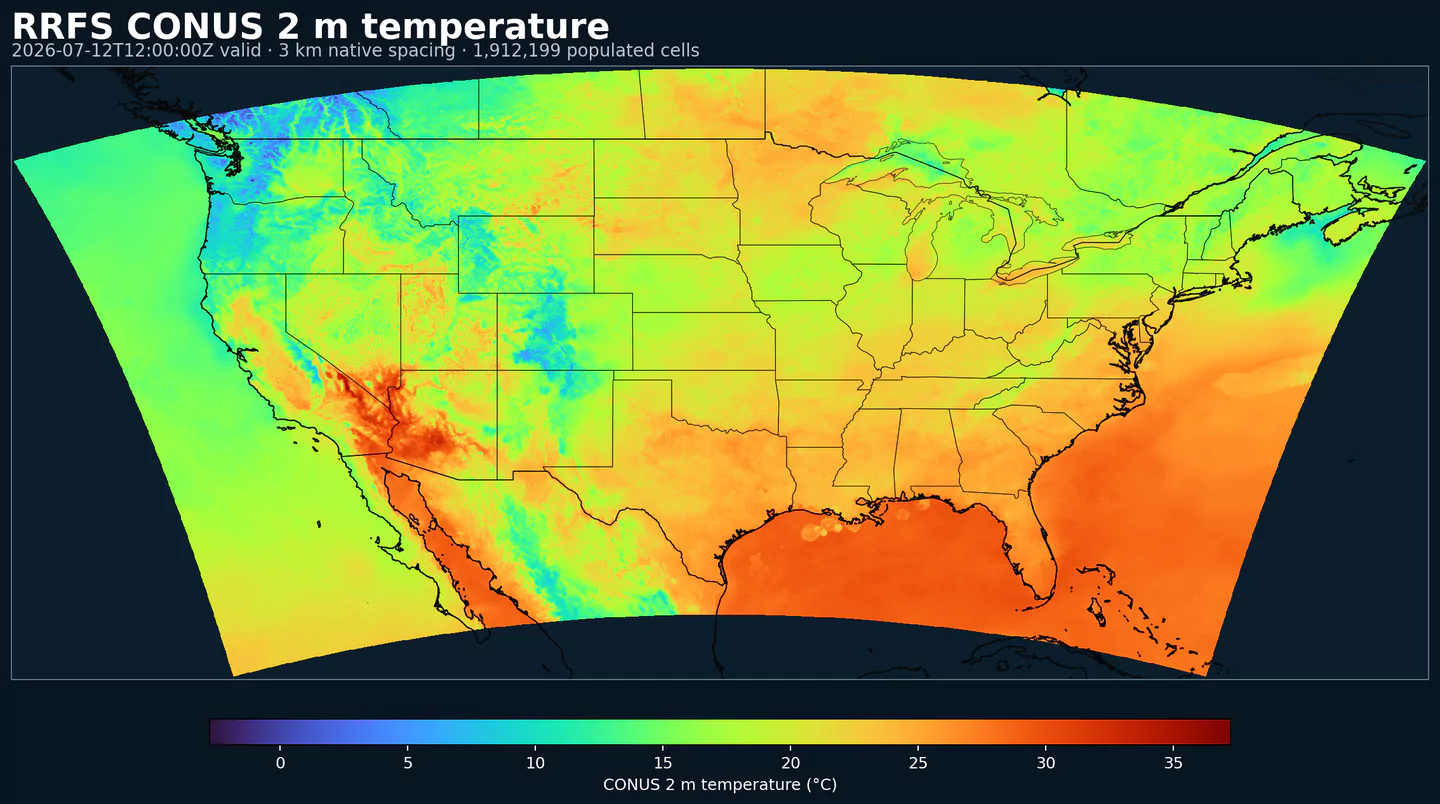
rrfs2dfld provides NOAA Rapid Refresh Forecast System (RRFS) 2D forecast fields on the CONUS grid. It contains the surface, near-surface, column, cloud, radiation, precipitation, soil, canopy, fire-weather, and storm-diagnostic variables that operational weather applications typically need from a short-range convection-allowing model.
RRFS is NOAA's next-generation rapidly updated prediction system for high-impact weather. The model family is developed within the Unified Forecast System (UFS), which brings shared model physics, data assimilation, pre-processing, post-processing, and verification into NOAA's research-to-operations forecast workflow.
RRFS 2D fields are useful for point weather APIs, energy forecasting, aviation and transportation decision support, heavy-rain and snow monitoring, convective nowcasting, surface wind and gust risk, cloud and visibility workflows, soil and land-surface signals, and machine-learning datasets that need storm-scale predictors over the contiguous United States.
rrfsprslev provides upper-air fields on isobaric levels.Click a parameter to reveal variants in a compact table with ready-to-copy JSON selectors.
Best (4-layer) lifted index uses parcels from the lowest four model layers to assess stability at 500 hPa. More negative values indicate greater instability.
| Level | Info | Horizon | Introduced | Selector |
|---|---|---|---|---|
180-0 mb above ground |
0h-84h | 15 days ago |
{"name":"4LFTX","level":"180-0 mb above ground","info":""}
|
Aerosol emission flux represents the rate at which aerosols are emitted into the atmosphere from the surface. It reflects source strength from dust, smoke, and other particulates.
| Level | Info | Horizon | Introduced | Selector |
|---|---|---|---|---|
entire atmosphere (considered as a single layer) |
aerosol=Dust dry | aerosol_size <1e-05 |
0h-84h | 15 days ago |
{"name":"AEMFLX","level":"entire atmosphere (considered as a single layer)","info":"aerosol=Dust dry | aerosol_size <1e-05"}
|
entire atmosphere (considered as a single layer) |
aerosol=Particulate organic matter dry | aerosol_size <2.5e-06 |
0h-84h | 15 days ago |
{"name":"AEMFLX","level":"entire atmosphere (considered as a single layer)","info":"aerosol=Particulate organic matter dry | aerosol_size <2.5e-06"}
|
Surface albedo is the fraction of incoming shortwave radiation reflected by the surface. Higher albedo means less solar energy absorbed and a cooler surface.
| Level | Info | Horizon | Introduced | Selector |
|---|---|---|---|---|
surface |
0h-84h | 15 days ago |
{"name":"ALBDO","level":"surface","info":""}
|
Aerosol optical thickness represents the column-integrated attenuation of solar radiation by aerosols. Larger values indicate hazier conditions and reduced surface sunlight.
| Level | Info | Horizon | Introduced | Selector |
|---|---|---|---|---|
entire atmosphere (considered as a single layer) |
0h-84h | 15 days ago |
{"name":"AOTK","level":"entire atmosphere (considered as a single layer)","info":""}
|
Accumulated precipitation represents the total water-equivalent amount of rain and snow during the output period. It is a primary field for hydrologic impacts and event totals.
| Level | Info | Horizon | Introduced | Selector |
|---|---|---|---|---|
surface |
1h-84h | 15 days ago |
{"name":"APCP","level":"surface","info":""}
|
|
surface |
acc-from-init |
1h-84h | 15 days ago |
{"name":"APCP","level":"surface","info":"acc-from-init"}
|
Accumulated snow depth is the total depth of snow on the ground over the period. It is a physical depth, not water equivalent.
| Level | Info | Horizon | Introduced | Selector |
|---|---|---|---|---|
surface |
acc-from-init |
1h-84h | 15 days ago |
{"name":"ASNOW","level":"surface","info":"acc-from-init"}
|
Brightness Temperature (K).
| Level | Info | Horizon | Introduced | Selector |
|---|---|---|---|---|
top of atmosphere |
0h-84h | 15 days ago |
{"name":"BRTEMP","level":"top of atmosphere","info":""}
|
Critical Angle (degree).
| Level | Info | Horizon | Introduced | Selector |
|---|---|---|---|---|
0-500 m above ground |
0h-84h | 15 days ago |
{"name":"CANGLE","level":"0-500 m above ground","info":""}
|
Convective Available Potential Energy (CAPE) quantifies buoyant energy available to rising air parcels. Larger values generally imply stronger potential updrafts and greater convective intensity.
| Level | Info | Horizon | Introduced | Selector |
|---|---|---|---|---|
0-3000 m above ground |
0h-84h | 15 days ago |
{"name":"CAPE","level":"0-3000 m above ground","info":""}
|
|
180-0 mb above ground |
0h-84h | 15 days ago |
{"name":"CAPE","level":"180-0 mb above ground","info":""}
|
|
255-0 mb above ground |
0h-84h | 15 days ago |
{"name":"CAPE","level":"255-0 mb above ground","info":""}
|
|
90-0 mb above ground |
0h-84h | 15 days ago |
{"name":"CAPE","level":"90-0 mb above ground","info":""}
|
|
surface |
0h-84h | 15 days ago |
{"name":"CAPE","level":"surface","info":""}
|
Drag coefficient represents the aerodynamic resistance between the surface and the atmosphere. It controls surface stress and is used in momentum and heat flux calculations.
| Level | Info | Horizon | Introduced | Selector |
|---|---|---|---|---|
surface |
0h-84h | 15 days ago |
{"name":"CD","level":"surface","info":""}
|
Ceiling height is the altitude of the lowest cloud base that covers a significant portion of the sky. It is a key aviation and surface-visibility metric.
| Level | Info | Horizon | Introduced | Selector |
|---|---|---|---|---|
cloud ceiling |
0h-84h | 15 days ago |
{"name":"CEIL","level":"cloud ceiling","info":""}
|
Categorical indicator of freezing rain occurrence at the surface during the output period.
| Level | Info | Horizon | Introduced | Selector |
|---|---|---|---|---|
surface |
0h-84h | 15 days ago |
{"name":"CFRZR","level":"surface","info":""}
|
Categorical indicator of ice pellet (sleet) occurrence at the surface during the output period.
| Level | Info | Horizon | Introduced | Selector |
|---|---|---|---|---|
surface |
0h-84h | 15 days ago |
{"name":"CICEP","level":"surface","info":""}
|
Convective Inhibition (CIN) measures the energy barrier that must be overcome to initiate convection. More negative values indicate a stronger cap that can suppress storms.
| Level | Info | Horizon | Introduced | Selector |
|---|---|---|---|---|
180-0 mb above ground |
0h-84h | 15 days ago |
{"name":"CIN","level":"180-0 mb above ground","info":""}
|
|
255-0 mb above ground |
0h-84h | 15 days ago |
{"name":"CIN","level":"255-0 mb above ground","info":""}
|
|
90-0 mb above ground |
0h-84h | 15 days ago |
{"name":"CIN","level":"90-0 mb above ground","info":""}
|
|
surface |
0h-84h | 15 days ago |
{"name":"CIN","level":"surface","info":""}
|
Column-integrated soil moisture is the vertically integrated amount of water stored in the soil column.
| Level | Info | Horizon | Introduced | Selector |
|---|---|---|---|---|
0 m underground |
0h-84h | 15 days ago |
{"name":"CISOILM","level":"0 m underground","info":""}
|
Plant canopy surface water is liquid water intercepted by vegetation. It represents interception storage and evaporation potential.
| Level | Info | Horizon | Introduced | Selector |
|---|---|---|---|---|
surface |
0h-84h | 15 days ago |
{"name":"CNWAT","level":"surface","info":""}
|
Column-integrated mass density is the total mass per unit area through the vertical column for the specified species. It summarizes column burden and is useful for transport diagnostics.
| Level | Info | Horizon | Introduced | Selector |
|---|---|---|---|---|
entire atmosphere (considered as a single layer) |
aerosol=Dust dry | aerosol_size <1e-05 |
0h-84h | 15 days ago |
{"name":"COLMD","level":"entire atmosphere (considered as a single layer)","info":"aerosol=Dust dry | aerosol_size <1e-05"}
|
entire atmosphere (considered as a single layer) |
aerosol=Dust dry | aerosol_size <2.5e-06 |
0h-84h | 15 days ago |
{"name":"COLMD","level":"entire atmosphere (considered as a single layer)","info":"aerosol=Dust dry | aerosol_size <2.5e-06"}
|
entire atmosphere (considered as a single layer) |
aerosol=Dust dry | aerosol_size >=2.5e-06,<1e-05 |
0h-84h | 15 days ago |
{"name":"COLMD","level":"entire atmosphere (considered as a single layer)","info":"aerosol=Dust dry | aerosol_size >=2.5e-06,<1e-05"}
|
entire atmosphere (considered as a single layer) |
aerosol=Particulate organic matter dry | aerosol_size <2.5e-06 |
0h-84h | 15 days ago |
{"name":"COLMD","level":"entire atmosphere (considered as a single layer)","info":"aerosol=Particulate organic matter dry | aerosol_size <2.5e-06"}
|
Percent frozen precipitation indicates the fraction of total precipitation that is falling in frozen form. It helps distinguish mixed-phase and winter precipitation impacts.
| Level | Info | Horizon | Introduced | Selector |
|---|---|---|---|---|
surface |
0h-84h | 15 days ago |
{"name":"CPOFP","level":"surface","info":""}
|
Categorical indicator of rain occurrence at the surface during the output period. Useful as a yes/no mask for rain.
| Level | Info | Horizon | Introduced | Selector |
|---|---|---|---|---|
surface |
0h-84h | 15 days ago |
{"name":"CRAIN","level":"surface","info":""}
|
Clear‑sky downward shortwave flux is broadband solar energy at the surface without cloud effects.
| Level | Info | Horizon | Introduced | Selector |
|---|---|---|---|---|
surface |
0h-84h | 15 days ago |
{"name":"CSDSF","level":"surface","info":""}
|
Categorical indicator of snow occurrence at the surface during the output period.
| Level | Info | Horizon | Introduced | Selector |
|---|---|---|---|---|
surface |
0h-84h | 15 days ago |
{"name":"CSNOW","level":"surface","info":""}
|
Downdraft Convective Available Potential Energy (J/kg).
| Level | Info | Horizon | Introduced | Selector |
|---|---|---|---|---|
400-0 mb above ground |
0h-84h | 15 days ago |
{"name":"DCAPE","level":"400-0 mb above ground","info":""}
|
Dew point depression is the difference between air temperature and dew point. Small values indicate near‑saturation.
| Level | Info | Horizon | Introduced | Selector |
|---|---|---|---|---|
2 m above ground |
0h-84h | 15 days ago |
{"name":"DEPR","level":"2 m above ground","info":""}
|
Downward longwave (thermal) flux represents incoming energy at the surface. It is a key driver of surface heating and cooling.
| Level | Info | Horizon | Introduced | Selector |
|---|---|---|---|---|
surface |
0h-84h | 15 days ago |
{"name":"DLWRF","level":"surface","info":""}
|
|
surface |
ave-1h |
1h-84h | 15 days ago |
{"name":"DLWRF","level":"surface","info":"ave-1h"}
|
Dew point temperature is the temperature at which the air becomes saturated. It is a direct measure of moisture content.
| Level | Info | Horizon | Introduced | Selector |
|---|---|---|---|---|
2 m above ground |
0h-84h | 15 days ago |
{"name":"DPT","level":"2 m above ground","info":""}
|
Downward radiative flux represents incoming energy at the surface. It is a key driver of surface heating and cooling.
| Level | Info | Horizon | Introduced | Selector |
|---|---|---|---|---|
surface |
0h-84h | 15 days ago |
{"name":"DSWRF","level":"surface","info":""}
|
|
surface |
ave-1h |
1h-84h | 15 days ago |
{"name":"DSWRF","level":"surface","info":"ave-1h"}
|
Effective Storm Relative Helicity (m2 s-2).
| Level | Info | Horizon | Introduced | Selector |
|---|---|---|---|---|
surface |
0h-84h | 15 days ago |
{"name":"EFHL","level":"surface","info":""}
|
Equilibrium Level Melting Potential (K).
| Level | Info | Horizon | Introduced | Selector |
|---|---|---|---|---|
equilibrium level |
0h-84h | 15 days ago |
{"name":"ELMELT","level":"equilibrium level","info":""}
|
East longitude gives the longitude position of the grid point in degrees east. It is a static geographic coordinate field.
| Level | Info | Horizon | Introduced | Selector |
|---|---|---|---|---|
surface |
0h-84h | 15 days ago |
{"name":"ELON","level":"surface","info":""}
|
Friction velocity (u*) is a measure of near‑surface shear stress. It is commonly used in turbulence, dust, and air‑sea exchange calculations.
| Level | Info | Horizon | Introduced | Selector |
|---|---|---|---|---|
surface |
0h-84h | 15 days ago |
{"name":"FRICV","level":"surface","info":""}
|
Freezing rain accumulation is the water-equivalent amount of freezing rain during the period. It relates directly to ice accretion risk.
| Level | Info | Horizon | Introduced | Selector |
|---|---|---|---|---|
surface |
1h-84h | 15 days ago |
{"name":"FROZR","level":"surface","info":""}
|
|
surface |
acc-from-init |
1h-84h | 15 days ago |
{"name":"FROZR","level":"surface","info":"acc-from-init"}
|
Freezing rain accumulation is the water-equivalent amount of freezing rain during the period. It relates directly to ice accretion risk.
| Level | Info | Horizon | Introduced | Selector |
|---|---|---|---|---|
surface |
1h-84h | 15 days ago |
{"name":"FRZR","level":"surface","info":""}
|
|
surface |
acc-from-init |
1h-84h | 15 days ago |
{"name":"FRZR","level":"surface","info":"acc-from-init"}
|
Ground heat flux is the conductive heat exchange between the surface and the subsurface. It is a key term in the surface energy balance.
| Level | Info | Horizon | Introduced | Selector |
|---|---|---|---|---|
surface |
0h-84h | 15 days ago |
{"name":"GFLUX","level":"surface","info":""}
|
|
surface |
ave-1h |
1h-84h | 15 days ago |
{"name":"GFLUX","level":"surface","info":"ave-1h"}
|
Wind gust is the peak short-duration wind speed. It captures brief, hazardous bursts that can exceed sustained winds.
| Level | Info | Horizon | Introduced | Selector |
|---|---|---|---|---|
surface |
0h-84h | 15 days ago |
{"name":"GUST","level":"surface","info":""}
|
Hail represents hail size as a length measure. Larger values indicate more severe hail potential.
| Level | Info | Horizon | Introduced | Selector |
|---|---|---|---|---|
surface |
max-1h |
1h-84h | 15 days ago |
{"name":"HAIL","level":"surface","info":"max-1h"}
|
High cloud cover is the fraction of the grid cell covered by clouds in the upper troposphere. It affects longwave radiation and aviation.
| Level | Info | Horizon | Introduced | Selector |
|---|---|---|---|---|
high cloud layer |
0h-84h | 15 days ago |
{"name":"HCDC","level":"high cloud layer","info":""}
|
Geopotential height is the altitude of a pressure surface in the atmosphere. It is the primary field for identifying ridges, troughs, and large‑scale flow patterns.
| Level | Info | Horizon | Introduced | Selector |
|---|---|---|---|---|
0C isotherm |
0h-84h | 15 days ago |
{"name":"HGT","level":"0C isotherm","info":""}
|
|
253 K level |
0h-84h | 15 days ago |
{"name":"HGT","level":"253 K level","info":""}
|
|
cloud base |
0h-84h | 15 days ago |
{"name":"HGT","level":"cloud base","info":""}
|
|
cloud ceiling |
0h-84h | 15 days ago |
{"name":"HGT","level":"cloud ceiling","info":""}
|
|
cloud top |
0h-84h | 15 days ago |
{"name":"HGT","level":"cloud top","info":""}
|
|
equilibrium level |
0h-84h | 15 days ago |
{"name":"HGT","level":"equilibrium level","info":""}
|
|
highest top level of supercooled liquid water layer |
0h-84h | 15 days ago |
{"name":"HGT","level":"highest top level of supercooled liquid water layer","info":""}
|
|
highest tropospheric freezing level |
0h-84h | 15 days ago |
{"name":"HGT","level":"highest tropospheric freezing level","info":""}
|
|
level of adiabatic condensation from sfc |
0h-84h | 15 days ago |
{"name":"HGT","level":"level of adiabatic condensation from sfc","info":""}
|
|
lowest bottom level of supercooled liquid water layer |
0h-84h | 15 days ago |
{"name":"HGT","level":"lowest bottom level of supercooled liquid water layer","info":""}
|
|
lowest level of the wet bulb zero |
0h-84h | 15 days ago |
{"name":"HGT","level":"lowest level of the wet bulb zero","info":""}
|
|
max wind |
0h-84h | 15 days ago |
{"name":"HGT","level":"max wind","info":""}
|
|
surface |
0h-84h | 15 days ago |
{"name":"HGT","level":"surface","info":""}
|
|
tropopause |
0h-84h | 15 days ago |
{"name":"HGT","level":"tropopause","info":""}
|
Mass Density Height (m).
| Level | Info | Horizon | Introduced | Selector |
|---|---|---|---|---|
entire atmosphere (considered as a single layer) |
0h-84h | 15 days ago |
{"name":"HGTMD","level":"entire atmosphere (considered as a single layer)","info":""}
|
|
highest level > 1e-09 kg/m^3 |
0h-84h | 15 days ago |
{"name":"HGTMD","level":"highest level > 1e-09 kg/m^3","info":""}
|
|
lowest level > 1e-09 kg/m^3 |
0h-84h | 15 days ago |
{"name":"HGTMD","level":"lowest level > 1e-09 kg/m^3","info":""}
|
Storm-relative helicity measures the potential for streamwise vorticity to be ingested by a storm updraft. Higher values suggest a greater likelihood of rotating updrafts.
| Level | Info | Horizon | Introduced | Selector |
|---|---|---|---|---|
1000-0 m above ground |
0h-84h | 15 days ago |
{"name":"HLCY","level":"1000-0 m above ground","info":""}
|
|
3000-0 m above ground |
0h-84h | 15 days ago |
{"name":"HLCY","level":"3000-0 m above ground","info":""}
|
Boundary layer height marks the depth of the turbulent surface-influenced layer. It affects mixing, dispersion, and surface fluxes.
| Level | Info | Horizon | Introduced | Selector |
|---|---|---|---|---|
surface |
0h-84h | 15 days ago |
{"name":"HPBL","level":"surface","info":""}
|
Ice cover is the proportion of the grid cell covered by ice. It is used as a surface-state mask for sea ice and related cryosphere diagnostics.
| Level | Info | Horizon | Introduced | Selector |
|---|---|---|---|---|
surface |
0h-84h | 15 days ago |
{"name":"ICEC","level":"surface","info":""}
|
Ice growth rate represents the rate of sea-ice thickness increase. It reflects freezing conditions at the surface and in the upper ocean.
| Level | Info | Horizon | Introduced | Selector |
|---|---|---|---|---|
10 m above mean sea level |
0h-84h | 15 days ago |
{"name":"ICEG","level":"10 m above mean sea level","info":""}
|
Leaf Area Index (dimensionless).
| Level | Info | Horizon | Introduced | Selector |
|---|---|---|---|---|
surface |
0h-84h | 15 days ago |
{"name":"LAI","level":"surface","info":""}
|
Land cover is a land/sea mask where 0 indicates sea and 1 indicates land. It is used to separate land and ocean surface processes.
| Level | Info | Horizon | Introduced | Selector |
|---|---|---|---|---|
surface |
0h-84h | 15 days ago |
{"name":"LAND","level":"surface","info":""}
|
Layer thickness is the vertical distance between the bounds of a layer. It helps interpret thermodynamic and lifted-layer diagnostics.
| Level | Info | Horizon | Introduced | Selector |
|---|---|---|---|---|
261 K level - 256 K level |
0h-84h | 15 days ago |
{"name":"LAYTH","level":"261 K level - 256 K level","info":""}
|
Low cloud cover is the fraction of the grid cell covered by low clouds. It strongly affects visibility, fog potential, and surface temperatures.
| Level | Info | Horizon | Introduced | Selector |
|---|---|---|---|---|
low cloud layer |
0h-84h | 15 days ago |
{"name":"LCDC","level":"low cloud layer","info":""}
|
Lifted Index compares a lifted parcel's temperature to the environment at 500 hPa. More negative values indicate greater instability and thunderstorm potential.
| Level | Info | Horizon | Introduced | Selector |
|---|---|---|---|---|
500-1000 mb |
0h-84h | 15 days ago |
{"name":"LFTX","level":"500-1000 mb","info":""}
|
Latent heat net flux represents energy exchange due to evaporation/condensation at the surface. It links moisture and energy budgets.
| Level | Info | Horizon | Introduced | Selector |
|---|---|---|---|---|
surface |
0h-84h | 15 days ago |
{"name":"LHTFL","level":"surface","info":""}
|
|
surface |
ave-1h |
1h-84h | 15 days ago |
{"name":"LHTFL","level":"surface","info":"ave-1h"}
|
Mass-Point Land Mask (flag).
| Level | Info | Horizon | Introduced | Selector |
|---|---|---|---|---|
surface |
0h-84h | 15 days ago |
{"name":"LMH","level":"surface","info":""}
|
Velocity-Point Land Mask (flag).
| Level | Info | Horizon | Introduced | Selector |
|---|---|---|---|---|
surface |
0h-84h | 15 days ago |
{"name":"LMV","level":"surface","info":""}
|
Lightning is a dimensionless model diagnostic in these NOAA mesoscale inventories. Higher values indicate greater modeled lightning or convective electrical activity.
| Level | Info | Horizon | Introduced | Selector |
|---|---|---|---|---|
entire atmosphere |
max-1h |
1h-84h | 15 days ago |
{"name":"LTNG","level":"entire atmosphere","info":"max-1h"}
|
Lightning Strike Density (flashes km-2).
| Level | Info | Horizon | Introduced | Selector |
|---|---|---|---|---|
1 m above ground |
max-1h |
1h-84h | 15 days ago |
{"name":"LTNGSD","level":"1 m above ground","info":"max-1h"}
|
2 m above ground |
max-1h |
1h-84h | 15 days ago |
{"name":"LTNGSD","level":"2 m above ground","info":"max-1h"}
|
Mass density (concentration) represents mass per unit volume of the named species or medium. It is used for concentration and transport analyses.
| Level | Info | Horizon | Introduced | Selector |
|---|---|---|---|---|
8 m above ground |
aerosol=Dust dry | aerosol_size <2.5e-06 |
0h-84h | 15 days ago |
{"name":"MASSDEN","level":"8 m above ground","info":"aerosol=Dust dry | aerosol_size <2.5e-06"}
|
8 m above ground |
aerosol=Dust dry | aerosol_size >=2.5e-06,<1e-05 |
0h-84h | 15 days ago |
{"name":"MASSDEN","level":"8 m above ground","info":"aerosol=Dust dry | aerosol_size >=2.5e-06,<1e-05"}
|
8 m above ground |
aerosol=Particulate organic matter dry | aerosol_size <2.5e-06 |
0h-84h | 15 days ago |
{"name":"MASSDEN","level":"8 m above ground","info":"aerosol=Particulate organic matter dry | aerosol_size <2.5e-06"}
|
8 m above ground |
aerosol=Total aerosol | aerosol_size <1e-05 | ave-1h |
1h-84h | 15 days ago |
{"name":"MASSDEN","level":"8 m above ground","info":"aerosol=Total aerosol | aerosol_size <1e-05 | ave-1h"}
|
8 m above ground |
aerosol=Total aerosol | aerosol_size <2.5e-06 | ave-1h |
1h-84h | 15 days ago |
{"name":"MASSDEN","level":"8 m above ground","info":"aerosol=Total aerosol | aerosol_size <2.5e-06 | ave-1h"}
|
Hourly maximum downward vertical velocity in the lowest 400 hPa highlights the strongest subsidence within the lower troposphere during the hour.
| Level | Info | Horizon | Introduced | Selector |
|---|---|---|---|---|
100-1000 mb |
max-1h |
1h-84h | 15 days ago |
{"name":"MAXDVV","level":"100-1000 mb","info":"max-1h"}
|
Hourly maximum simulated reflectivity at 1 km AGL captures the strongest modeled reflectivity near the surface. It is used to identify peak convective intensity and heavy precipitation cores.
| Level | Info | Horizon | Introduced | Selector |
|---|---|---|---|---|
1000 m above ground |
max-1h |
1h-84h | 15 days ago |
{"name":"MAXREF","level":"1000 m above ground","info":"max-1h"}
|
263 K level |
max-1h |
1h-84h | 15 days ago |
{"name":"MAXREF","level":"263 K level","info":"max-1h"}
|
Maximum relative humidity is the highest RH reached during the period. It can indicate peak cloud or fog potential.
| Level | Info | Horizon | Introduced | Selector |
|---|---|---|---|---|
2 m above ground |
max-1h |
1h-84h | 15 days ago |
{"name":"MAXRH","level":"2 m above ground","info":"max-1h"}
|
Hourly maximum upward vertical velocity in the lowest 400 hPa highlights the strongest updrafts within the lower troposphere during the hour.
| Level | Info | Horizon | Introduced | Selector |
|---|---|---|---|---|
100-1000 mb |
max-1h |
1h-84h | 15 days ago |
{"name":"MAXUVV","level":"100-1000 mb","info":"max-1h"}
|
Maximum u‑component of wind is the strongest east‑west flow during the period. It helps identify peak wind directions.
| Level | Info | Horizon | Introduced | Selector |
|---|---|---|---|---|
10 m above ground |
max-1h |
1h-84h | 15 days ago |
{"name":"MAXUW","level":"10 m above ground","info":"max-1h"}
|
Maximum v‑component of wind is the strongest north‑south flow during the period.
| Level | Info | Horizon | Introduced | Selector |
|---|---|---|---|---|
10 m above ground |
max-1h |
1h-84h | 15 days ago |
{"name":"MAXVW","level":"10 m above ground","info":"max-1h"}
|
Mid-level cloud cover is the fraction of the grid cell covered by clouds in the middle troposphere. It influences both shortwave and longwave radiation.
| Level | Info | Horizon | Introduced | Selector |
|---|---|---|---|---|
middle cloud layer |
0h-84h | 15 days ago |
{"name":"MCDC","level":"middle cloud layer","info":""}
|
Moisture convergence is the horizontal convergence of water vapor transport. Areas of convergence favor rising motion and precipitation development.
| Level | Info | Horizon | Introduced | Selector |
|---|---|---|---|---|
entire atmosphere (considered as a single layer) |
0h-84h | 15 days ago |
{"name":"MCONV","level":"entire atmosphere (considered as a single layer)","info":""}
|
Minimum relative humidity is the lowest RH reached during the period. It is used in fire‑weather and drying assessments.
| Level | Info | Horizon | Introduced | Selector |
|---|---|---|---|---|
2 m above ground |
min-1h |
1h-84h | 15 days ago |
{"name":"MINRH","level":"2 m above ground","info":"min-1h"}
|
Hourly minimum updraft helicity is the lowest helicity value during the hour. It provides a lower bound on rotating updraft potential.
| Level | Info | Horizon | Introduced | Selector |
|---|---|---|---|---|
3000-0 m above ground |
min-1h |
1h-84h | 15 days ago |
{"name":"MNUPHL","level":"3000-0 m above ground","info":"min-1h"}
|
5000-2000 m above ground |
min-1h |
1h-84h | 15 days ago |
{"name":"MNUPHL","level":"5000-2000 m above ground","info":"min-1h"}
|
Mean sea level pressure (ETA reduction) is MSLP computed using the ETA model reduction method. It is used for synoptic analysis.
| Level | Info | Horizon | Introduced | Selector |
|---|---|---|---|---|
mean sea level |
0h-84h | 15 days ago |
{"name":"MSLET","level":"mean sea level","info":""}
|
Moisture availability represents how much moisture is available at the surface for evaporation. It is used in land-surface and fire-weather diagnostics.
| Level | Info | Horizon | Introduced | Selector |
|---|---|---|---|---|
0 m underground |
0h-84h | 15 days ago |
{"name":"MSTAV","level":"0 m underground","info":""}
|
Maximum snow albedo is the highest reflectivity of the snow surface during the period. Higher values indicate fresher, brighter snow.
| Level | Info | Horizon | Introduced | Selector |
|---|---|---|---|---|
surface |
0h-84h | 15 days ago |
{"name":"MXSALB","level":"surface","info":""}
|
Hourly maximum updraft helicity (2–5 km AGL) highlights the strongest rotating updrafts during the hour.
| Level | Info | Horizon | Introduced | Selector |
|---|---|---|---|---|
3000-0 m above ground |
max-1h |
1h-84h | 15 days ago |
{"name":"MXUPHL","level":"3000-0 m above ground","info":"max-1h"}
|
5000-2000 m above ground |
max-1h |
1h-84h | 15 days ago |
{"name":"MXUPHL","level":"5000-2000 m above ground","info":"max-1h"}
|
North latitude gives the latitude position of the grid point in degrees north. It is a static geographic coordinate field.
| Level | Info | Horizon | Introduced | Selector |
|---|---|---|---|---|
surface |
0h-84h | 15 days ago |
{"name":"NLAT","level":"surface","info":""}
|
Potential evaporation is the amount of water that could evaporate if sufficient moisture were available. It reflects atmospheric demand.
| Level | Info | Horizon | Introduced | Selector |
|---|---|---|---|---|
surface |
1h-84h | 15 days ago |
{"name":"PEVAP","level":"surface","info":""}
|
Potential evaporation rate is the potential latent heat flux for evaporation under an assumed unlimited water supply.
| Level | Info | Horizon | Introduced | Selector |
|---|---|---|---|---|
surface |
0h-84h | 15 days ago |
{"name":"PEVPR","level":"surface","info":""}
|
Pressure of the level from which the parcel was lifted indicates the parcel source level used for stability indices. It helps interpret lifted index and CAPE products.
| Level | Info | Horizon | Introduced | Selector |
|---|---|---|---|---|
255-0 mb above ground |
0h-84h | 15 days ago |
{"name":"PLPL","level":"255-0 mb above ground","info":""}
|
Soil porosity is the fraction of soil volume that is pore space. It governs storage and drainage capacity.
| Level | Info | Horizon | Introduced | Selector |
|---|---|---|---|---|
surface |
0h-84h | 15 days ago |
{"name":"POROS","level":"surface","info":""}
|
Potential temperature is the temperature a parcel would have if brought dry‑adiabatically to a reference pressure. It is used for stability.
| Level | Info | Horizon | Introduced | Selector |
|---|---|---|---|---|
surface |
0h-84h | 15 days ago |
{"name":"POT","level":"surface","info":""}
|
|
tropopause |
0h-84h | 15 days ago |
{"name":"POT","level":"tropopause","info":""}
|
Precipitation rate is the total intensity of precipitation over the period. It combines convective and stratiform contributions.
| Level | Info | Horizon | Introduced | Selector |
|---|---|---|---|---|
surface |
0h-84h | 15 days ago |
{"name":"PRATE","level":"surface","info":""}
|
|
surface |
max-1h |
1h-84h | 15 days ago |
{"name":"PRATE","level":"surface","info":"max-1h"}
|
Pressure is the atmospheric pressure at the specified level. It is a fundamental mass-field variable for dynamics and thermodynamics.
| Level | Info | Horizon | Introduced | Selector |
|---|---|---|---|---|
0C isotherm |
0h-84h | 15 days ago |
{"name":"PRES","level":"0C isotherm","info":""}
|
|
80 m above ground |
0h-84h | 15 days ago |
{"name":"PRES","level":"80 m above ground","info":""}
|
|
cloud base |
0h-84h | 15 days ago |
{"name":"PRES","level":"cloud base","info":""}
|
|
cloud top |
0h-84h | 15 days ago |
{"name":"PRES","level":"cloud top","info":""}
|
|
grid scale cloud bottom level |
0h-84h | 15 days ago |
{"name":"PRES","level":"grid scale cloud bottom level","info":""}
|
|
grid scale cloud top level |
0h-84h | 15 days ago |
{"name":"PRES","level":"grid scale cloud top level","info":""}
|
|
highest tropospheric freezing level |
0h-84h | 15 days ago |
{"name":"PRES","level":"highest tropospheric freezing level","info":""}
|
|
level of adiabatic condensation from sfc |
0h-84h | 15 days ago |
{"name":"PRES","level":"level of adiabatic condensation from sfc","info":""}
|
|
max wind |
0h-84h | 15 days ago |
{"name":"PRES","level":"max wind","info":""}
|
|
surface |
0h-84h | 15 days ago |
{"name":"PRES","level":"surface","info":""}
|
|
top of atmosphere |
0h-84h | 15 days ago |
{"name":"PRES","level":"top of atmosphere","info":""}
|
|
tropopause |
0h-84h | 15 days ago |
{"name":"PRES","level":"tropopause","info":""}
|
Precipitable water is the total column water vapor from the surface to the top of the atmosphere. It is a key moisture indicator.
| Level | Info | Horizon | Introduced | Selector |
|---|---|---|---|---|
entire atmosphere (considered as a single layer) |
0h-84h | 15 days ago |
{"name":"PWAT","level":"entire atmosphere (considered as a single layer)","info":""}
|
Composite reflectivity is the maximum reflectivity in the column. It is a standard radar‑style field for identifying convective cores and precipitation intensity.
| Level | Info | Horizon | Introduced | Selector |
|---|---|---|---|---|
entire atmosphere (considered as a single layer) |
0h-84h | 15 days ago |
{"name":"REFC","level":"entire atmosphere (considered as a single layer)","info":""}
|
Reflectivity is a radar‑style measure of hydrometeor concentration at a given level. Higher values generally correspond to heavier precipitation.
| Level | Info | Horizon | Introduced | Selector |
|---|---|---|---|---|
1000 m above ground |
0h-84h | 15 days ago |
{"name":"REFD","level":"1000 m above ground","info":""}
|
|
263 K level |
0h-84h | 15 days ago |
{"name":"REFD","level":"263 K level","info":""}
|
|
4000 m above ground |
0h-84h | 15 days ago |
{"name":"REFD","level":"4000 m above ground","info":""}
|
Relative vorticity measures local rotation of the horizontal wind field. Positive values indicate cyclonic rotation and negative values anticyclonic rotation.
| Level | Info | Horizon | Introduced | Selector |
|---|---|---|---|---|
1 hybrid level |
max-1h |
1h-84h | 15 days ago |
{"name":"RELV","level":"1 hybrid level","info":"max-1h"}
|
1000-0 m above ground |
max-1h |
1h-84h | 15 days ago |
{"name":"RELV","level":"1000-0 m above ground","info":"max-1h"}
|
2000-0 m above ground |
max-1h |
1h-84h | 15 days ago |
{"name":"RELV","level":"2000-0 m above ground","info":"max-1h"}
|
Echo top height is the altitude of the highest reflectivity in the column. It is a proxy for storm depth and convective vigor.
| Level | Info | Horizon | Introduced | Selector |
|---|---|---|---|---|
entire atmosphere (considered as a single layer) |
0h-84h | 15 days ago |
{"name":"RETOP","level":"entire atmosphere (considered as a single layer)","info":""}
|
Relative humidity describes how close the air is to saturation at the specified level. High values favor cloud formation.
| Level | Info | Horizon | Introduced | Selector |
|---|---|---|---|---|
0C isotherm |
0h-84h | 15 days ago |
{"name":"RH","level":"0C isotherm","info":""}
|
|
2 m above ground |
0h-84h | 15 days ago |
{"name":"RH","level":"2 m above ground","info":""}
|
|
highest tropospheric freezing level |
0h-84h | 15 days ago |
{"name":"RH","level":"highest tropospheric freezing level","info":""}
|
Relative humidity with respect to precipitable water is a column‑scale moisture indicator based on total water vapor content.
| Level | Info | Horizon | Introduced | Selector |
|---|---|---|---|---|
entire atmosphere |
0h-84h | 15 days ago |
{"name":"RHPW","level":"entire atmosphere","info":""}
|
Number of soil layers is a static model metadata field describing the soil discretization.
| Level | Info | Horizon | Introduced | Selector |
|---|---|---|---|---|
surface |
0h-84h | 15 days ago |
{"name":"RLYRS","level":"surface","info":""}
|
Minimum stomatal resistance is a vegetation parameter controlling transpiration efficiency. Lower values allow stronger evapotranspiration under favorable conditions.
| Level | Info | Horizon | Introduced | Selector |
|---|---|---|---|---|
surface |
0h-84h | 15 days ago |
{"name":"RSMIN","level":"surface","info":""}
|
Snow sublimation is the loss of snow directly to water vapor. It reduces snowpack without melting and can be important in dry, windy conditions.
| Level | Info | Horizon | Introduced | Selector |
|---|---|---|---|---|
surface |
0h-84h | 15 days ago |
{"name":"SBSNO","level":"surface","info":""}
|
Simulated Brightness Temperature ABI Channel 10 (K).
| Level | Info | Horizon | Introduced | Selector |
|---|---|---|---|---|
top of atmosphere |
0h-84h | 15 days ago |
{"name":"SBTA1610","level":"top of atmosphere","info":""}
|
Simulated Brightness Temperature ABI Channel 11 (K).
| Level | Info | Horizon | Introduced | Selector |
|---|---|---|---|---|
top of atmosphere |
0h-84h | 15 days ago |
{"name":"SBTA1611","level":"top of atmosphere","info":""}
|
Simulated Brightness Temperature ABI Channel 12 (K).
| Level | Info | Horizon | Introduced | Selector |
|---|---|---|---|---|
top of atmosphere |
0h-84h | 15 days ago |
{"name":"SBTA1612","level":"top of atmosphere","info":""}
|
Simulated Brightness Temperature ABI Channel 13 (K).
| Level | Info | Horizon | Introduced | Selector |
|---|---|---|---|---|
top of atmosphere |
0h-84h | 15 days ago |
{"name":"SBTA1613","level":"top of atmosphere","info":""}
|
Simulated Brightness Temperature ABI Channel 14 (K).
| Level | Info | Horizon | Introduced | Selector |
|---|---|---|---|---|
top of atmosphere |
0h-84h | 15 days ago |
{"name":"SBTA1614","level":"top of atmosphere","info":""}
|
Simulated Brightness Temperature ABI Channel 15 (K).
| Level | Info | Horizon | Introduced | Selector |
|---|---|---|---|---|
top of atmosphere |
0h-84h | 15 days ago |
{"name":"SBTA1615","level":"top of atmosphere","info":""}
|
Simulated Brightness Temperature ABI Channel 16 (K).
| Level | Info | Horizon | Introduced | Selector |
|---|---|---|---|---|
top of atmosphere |
0h-84h | 15 days ago |
{"name":"SBTA1616","level":"top of atmosphere","info":""}
|
Simulated Brightness Temperature ABI Channel 7 (K).
| Level | Info | Horizon | Introduced | Selector |
|---|---|---|---|---|
top of atmosphere |
0h-84h | 15 days ago |
{"name":"SBTA167","level":"top of atmosphere","info":""}
|
Simulated Brightness Temperature ABI Channel 8 (K).
| Level | Info | Horizon | Introduced | Selector |
|---|---|---|---|---|
top of atmosphere |
0h-84h | 15 days ago |
{"name":"SBTA168","level":"top of atmosphere","info":""}
|
Simulated Brightness Temperature ABI Channel 9 (K).
| Level | Info | Horizon | Introduced | Selector |
|---|---|---|---|---|
top of atmosphere |
0h-84h | 15 days ago |
{"name":"SBTA169","level":"top of atmosphere","info":""}
|
Snow Density (kg m-3).
| Level | Info | Horizon | Introduced | Selector |
|---|---|---|---|---|
surface |
0h-84h | 15 days ago |
{"name":"SDEN","level":"surface","info":""}
|
Surface roughness length is the effective height of surface obstacles that control drag. It strongly influences near-surface wind, turbulence, and exchange fluxes.
| Level | Info | Horizon | Introduced | Selector |
|---|---|---|---|---|
surface |
0h-84h | 15 days ago |
{"name":"SFCR","level":"surface","info":""}
|
Surface exchange coefficient is the bulk transfer coefficient used to compute turbulent heat and moisture fluxes. It depends on stability and roughness.
| Level | Info | Horizon | Introduced | Selector |
|---|---|---|---|---|
surface |
0h-84h | 15 days ago |
{"name":"SFEXC","level":"surface","info":""}
|
Sensible heat net flux is turbulent heat exchange driven by temperature differences. It affects near‑surface temperature and stability.
| Level | Info | Horizon | Introduced | Selector |
|---|---|---|---|---|
surface |
0h-84h | 15 days ago |
{"name":"SHTFL","level":"surface","info":""}
|
|
surface |
ave-1h |
1h-84h | 15 days ago |
{"name":"SHTFL","level":"surface","info":"ave-1h"}
|
Direct evaporation cease (soil moisture) is the threshold below which bare-soil evaporation is shut off in the land-surface model.
| Level | Info | Horizon | Introduced | Selector |
|---|---|---|---|---|
surface |
0h-84h | 15 days ago |
{"name":"SMDRY","level":"surface","info":""}
|
Transpiration stress-onset (soil moisture) is the threshold at which plants begin to experience moisture stress in the land-surface model.
| Level | Info | Horizon | Introduced | Selector |
|---|---|---|---|---|
surface |
0h-84h | 15 days ago |
{"name":"SMREF","level":"surface","info":""}
|
Snow depth is the physical thickness of the snowpack. It is distinct from snow water equivalent, which measures water content.
| Level | Info | Horizon | Introduced | Selector |
|---|---|---|---|---|
surface |
0h-84h | 15 days ago |
{"name":"SNOD","level":"surface","info":""}
|
Snow phase change heat flux is the energy used for melting or freezing snow. It links radiation and snowpack evolution.
| Level | Info | Horizon | Introduced | Selector |
|---|---|---|---|---|
surface |
ave-1h |
1h-84h | 15 days ago |
{"name":"SNOHF","level":"surface","info":"ave-1h"}
|
Snow melt represents water released by melting snowpack during the period. It is a key driver of runoff and flooding.
| Level | Info | Horizon | Introduced | Selector |
|---|---|---|---|---|
surface |
1h-84h | 15 days ago |
{"name":"SNOM","level":"surface","info":""}
|
Snow cover is the fraction of the grid cell covered by snow. It helps interpret albedo, runoff timing, and surface energy balance.
| Level | Info | Horizon | Introduced | Selector |
|---|---|---|---|---|
surface |
0h-84h | 15 days ago |
{"name":"SNOWC","level":"surface","info":""}
|
Liquid volumetric soil moisture (non-frozen) is the liquid portion of soil water expressed as a proportion of soil volume, excluding soil ice.
| Level | Info | Horizon | Introduced | Selector |
|---|---|---|---|---|
0-0 m below ground |
0h-84h | 15 days ago |
{"name":"SOILL","level":"0-0 m below ground","info":""}
|
|
0.01-0.01 m below ground |
0h-84h | 15 days ago |
{"name":"SOILL","level":"0.01-0.01 m below ground","info":""}
|
|
0.04-0.04 m below ground |
0h-84h | 15 days ago |
{"name":"SOILL","level":"0.04-0.04 m below ground","info":""}
|
|
0.1-0.1 m below ground |
0h-84h | 15 days ago |
{"name":"SOILL","level":"0.1-0.1 m below ground","info":""}
|
|
0.3-0.3 m below ground |
0h-84h | 15 days ago |
{"name":"SOILL","level":"0.3-0.3 m below ground","info":""}
|
|
0.6-0.6 m below ground |
0h-84h | 15 days ago |
{"name":"SOILL","level":"0.6-0.6 m below ground","info":""}
|
|
1-1 m below ground |
0h-84h | 15 days ago |
{"name":"SOILL","level":"1-1 m below ground","info":""}
|
|
1.6-1.6 m below ground |
0h-84h | 15 days ago |
{"name":"SOILL","level":"1.6-1.6 m below ground","info":""}
|
|
3-3 m below ground |
0h-84h | 15 days ago |
{"name":"SOILL","level":"3-3 m below ground","info":""}
|
Volumetric soil moisture is the fraction of soil volume occupied by water. It is commonly used in hydrology and drought monitoring.
| Level | Info | Horizon | Introduced | Selector |
|---|---|---|---|---|
0-0 m below ground |
0h-84h | 15 days ago |
{"name":"SOILW","level":"0-0 m below ground","info":""}
|
|
0.01-0.01 m below ground |
0h-84h | 15 days ago |
{"name":"SOILW","level":"0.01-0.01 m below ground","info":""}
|
|
0.04-0.04 m below ground |
0h-84h | 15 days ago |
{"name":"SOILW","level":"0.04-0.04 m below ground","info":""}
|
|
0.1-0.1 m below ground |
0h-84h | 15 days ago |
{"name":"SOILW","level":"0.1-0.1 m below ground","info":""}
|
|
0.3-0.3 m below ground |
0h-84h | 15 days ago |
{"name":"SOILW","level":"0.3-0.3 m below ground","info":""}
|
|
0.6-0.6 m below ground |
0h-84h | 15 days ago |
{"name":"SOILW","level":"0.6-0.6 m below ground","info":""}
|
|
1-1 m below ground |
0h-84h | 15 days ago |
{"name":"SOILW","level":"1-1 m below ground","info":""}
|
|
1.6-1.6 m below ground |
0h-84h | 15 days ago |
{"name":"SOILW","level":"1.6-1.6 m below ground","info":""}
|
|
3-3 m below ground |
0h-84h | 15 days ago |
{"name":"SOILW","level":"3-3 m below ground","info":""}
|
Soil type class used by the land-surface model. It controls infiltration, drainage, and heat/moisture storage, and strongly affects runoff and evapotranspiration.
| Level | Info | Horizon | Introduced | Selector |
|---|---|---|---|---|
surface |
0h-84h | 15 days ago |
{"name":"SOTYP","level":"surface","info":""}
|
Specific humidity is the mass of water vapor per mass of air at the specified level. It is central to moisture transport.
| Level | Info | Horizon | Introduced | Selector |
|---|---|---|---|---|
2 m above ground |
0h-84h | 15 days ago |
{"name":"SPFH","level":"2 m above ground","info":""}
|
|
305 m above mean sea level |
0h-84h | 15 days ago |
{"name":"SPFH","level":"305 m above mean sea level","info":""}
|
|
80 m above ground |
0h-84h | 15 days ago |
{"name":"SPFH","level":"80 m above ground","info":""}
|
|
surface |
0h-84h | 15 days ago |
{"name":"SPFH","level":"surface","info":""}
|
Storm surface runoff represents overland flow generated by rainfall or snowmelt. It responds quickly to heavy precipitation.
| Level | Info | Horizon | Introduced | Selector |
|---|---|---|---|---|
surface |
1h-84h | 15 days ago |
{"name":"SSRUN","level":"surface","info":""}
|
Total cloud cover is the fraction of the grid cell covered by clouds at any level. It influences radiation, temperature, and visibility.
| Level | Info | Horizon | Introduced | Selector |
|---|---|---|---|---|
boundary layer cloud layer |
0h-84h | 15 days ago |
{"name":"TCDC","level":"boundary layer cloud layer","info":""}
|
|
entire atmosphere (considered as a single layer) |
0h-84h | 15 days ago |
{"name":"TCDC","level":"entire atmosphere (considered as a single layer)","info":""}
|
|
entire atmosphere (considered as a single layer) |
ave-1h |
1h-84h | 15 days ago |
{"name":"TCDC","level":"entire atmosphere (considered as a single layer)","info":"ave-1h"}
|
Maximum temperature is the highest temperature reached during the output period. It is commonly used for heat stress and daily extremes.
| Level | Info | Horizon | Introduced | Selector |
|---|---|---|---|---|
2 m above ground |
max-1h |
1h-84h | 15 days ago |
{"name":"TMAX","level":"2 m above ground","info":"max-1h"}
|
Minimum temperature is the lowest temperature reached during the output period. It is commonly used for frost and cold-stress assessment.
| Level | Info | Horizon | Introduced | Selector |
|---|---|---|---|---|
2 m above ground |
min-1h |
1h-84h | 15 days ago |
{"name":"TMIN","level":"2 m above ground","info":"min-1h"}
|
Air temperature is the thermal state of the atmosphere at the specified level. It influences density, stability, and energy exchange.
| Level | Info | Horizon | Introduced | Selector |
|---|---|---|---|---|
100 m above ground |
0h-84h | 15 days ago |
{"name":"TMP","level":"100 m above ground","info":""}
|
|
1524 m above mean sea level |
0h-84h | 15 days ago |
{"name":"TMP","level":"1524 m above mean sea level","info":""}
|
|
160 m above ground |
0h-84h | 15 days ago |
{"name":"TMP","level":"160 m above ground","info":""}
|
|
1829 m above mean sea level |
0h-84h | 15 days ago |
{"name":"TMP","level":"1829 m above mean sea level","info":""}
|
|
2 m above ground |
0h-84h | 15 days ago |
{"name":"TMP","level":"2 m above ground","info":""}
|
|
2134 m above mean sea level |
0h-84h | 15 days ago |
{"name":"TMP","level":"2134 m above mean sea level","info":""}
|
|
2743 m above mean sea level |
0h-84h | 15 days ago |
{"name":"TMP","level":"2743 m above mean sea level","info":""}
|
|
30 m above ground |
0h-84h | 15 days ago |
{"name":"TMP","level":"30 m above ground","info":""}
|
|
305 m above mean sea level |
0h-84h | 15 days ago |
{"name":"TMP","level":"305 m above mean sea level","info":""}
|
|
320 m above ground |
0h-84h | 15 days ago |
{"name":"TMP","level":"320 m above ground","info":""}
|
|
3658 m above mean sea level |
0h-84h | 15 days ago |
{"name":"TMP","level":"3658 m above mean sea level","info":""}
|
|
457 m above mean sea level |
0h-84h | 15 days ago |
{"name":"TMP","level":"457 m above mean sea level","info":""}
|
|
4572 m above mean sea level |
0h-84h | 15 days ago |
{"name":"TMP","level":"4572 m above mean sea level","info":""}
|
|
50 m above ground |
0h-84h | 15 days ago |
{"name":"TMP","level":"50 m above ground","info":""}
|
|
610 m above mean sea level |
0h-84h | 15 days ago |
{"name":"TMP","level":"610 m above mean sea level","info":""}
|
|
80 m above ground |
0h-84h | 15 days ago |
{"name":"TMP","level":"80 m above ground","info":""}
|
|
914 m above mean sea level |
0h-84h | 15 days ago |
{"name":"TMP","level":"914 m above mean sea level","info":""}
|
|
cloud top |
0h-84h | 15 days ago |
{"name":"TMP","level":"cloud top","info":""}
|
|
surface |
0h-84h | 15 days ago |
{"name":"TMP","level":"surface","info":""}
|
|
tropopause |
0h-84h | 15 days ago |
{"name":"TMP","level":"tropopause","info":""}
|
Soil temperature describes the thermal state of the soil layer. It affects ground heat flux and freeze/thaw processes.
| Level | Info | Horizon | Introduced | Selector |
|---|---|---|---|---|
0-0 m below ground |
0h-84h | 15 days ago |
{"name":"TSOIL","level":"0-0 m below ground","info":""}
|
|
0.01-0.01 m below ground |
0h-84h | 15 days ago |
{"name":"TSOIL","level":"0.01-0.01 m below ground","info":""}
|
|
0.04-0.04 m below ground |
0h-84h | 15 days ago |
{"name":"TSOIL","level":"0.04-0.04 m below ground","info":""}
|
|
0.1-0.1 m below ground |
0h-84h | 15 days ago |
{"name":"TSOIL","level":"0.1-0.1 m below ground","info":""}
|
|
0.3-0.3 m below ground |
0h-84h | 15 days ago |
{"name":"TSOIL","level":"0.3-0.3 m below ground","info":""}
|
|
0.6-0.6 m below ground |
0h-84h | 15 days ago |
{"name":"TSOIL","level":"0.6-0.6 m below ground","info":""}
|
|
1-1 m below ground |
0h-84h | 15 days ago |
{"name":"TSOIL","level":"1-1 m below ground","info":""}
|
|
1.6-1.6 m below ground |
0h-84h | 15 days ago |
{"name":"TSOIL","level":"1.6-1.6 m below ground","info":""}
|
|
3-3 m below ground |
0h-84h | 15 days ago |
{"name":"TSOIL","level":"3-3 m below ground","info":""}
|
U-Component of Effective Inflow Layer Wind (m/s).
| Level | Info | Horizon | Introduced | Selector |
|---|---|---|---|---|
level of free convection |
0h-84h | 15 days ago |
{"name":"UEID","level":"level of free convection","info":""}
|
U-Component of Effective Shear (m/s).
| Level | Info | Horizon | Introduced | Selector |
|---|---|---|---|---|
level of free convection |
0h-84h | 15 days ago |
{"name":"UESH","level":"level of free convection","info":""}
|
U‑component of wind is the east‑west component of the horizontal wind. Combine with v for speed and direction.
| Level | Info | Horizon | Introduced | Selector |
|---|---|---|---|---|
10 m above ground |
0h-84h | 15 days ago |
{"name":"UGRD","level":"10 m above ground","info":""}
|
|
100 m above ground |
0h-84h | 15 days ago |
{"name":"UGRD","level":"100 m above ground","info":""}
|
|
1524 m above mean sea level |
0h-84h | 15 days ago |
{"name":"UGRD","level":"1524 m above mean sea level","info":""}
|
|
160 m above ground |
0h-84h | 15 days ago |
{"name":"UGRD","level":"160 m above ground","info":""}
|
|
1829 m above mean sea level |
0h-84h | 15 days ago |
{"name":"UGRD","level":"1829 m above mean sea level","info":""}
|
|
2134 m above mean sea level |
0h-84h | 15 days ago |
{"name":"UGRD","level":"2134 m above mean sea level","info":""}
|
|
2743 m above mean sea level |
0h-84h | 15 days ago |
{"name":"UGRD","level":"2743 m above mean sea level","info":""}
|
|
30 m above ground |
0h-84h | 15 days ago |
{"name":"UGRD","level":"30 m above ground","info":""}
|
|
305 m above mean sea level |
0h-84h | 15 days ago |
{"name":"UGRD","level":"305 m above mean sea level","info":""}
|
|
320 m above ground |
0h-84h | 15 days ago |
{"name":"UGRD","level":"320 m above ground","info":""}
|
|
3658 m above mean sea level |
0h-84h | 15 days ago |
{"name":"UGRD","level":"3658 m above mean sea level","info":""}
|
|
457 m above mean sea level |
0h-84h | 15 days ago |
{"name":"UGRD","level":"457 m above mean sea level","info":""}
|
|
4572 m above mean sea level |
0h-84h | 15 days ago |
{"name":"UGRD","level":"4572 m above mean sea level","info":""}
|
|
50 m above ground |
0h-84h | 15 days ago |
{"name":"UGRD","level":"50 m above ground","info":""}
|
|
610 m above mean sea level |
0h-84h | 15 days ago |
{"name":"UGRD","level":"610 m above mean sea level","info":""}
|
|
80 m above ground |
0h-84h | 15 days ago |
{"name":"UGRD","level":"80 m above ground","info":""}
|
|
914 m above mean sea level |
0h-84h | 15 days ago |
{"name":"UGRD","level":"914 m above mean sea level","info":""}
|
|
max wind |
0h-84h | 15 days ago |
{"name":"UGRD","level":"max wind","info":""}
|
|
planetary boundary layer |
0h-84h | 15 days ago |
{"name":"UGRD","level":"planetary boundary layer","info":""}
|
|
tropopause |
0h-84h | 15 days ago |
{"name":"UGRD","level":"tropopause","info":""}
|
Upward longwave (thermal) flux represents outgoing energy at the surface. It is a key driver of surface heating and cooling.
| Level | Info | Horizon | Introduced | Selector |
|---|---|---|---|---|
surface |
0h-84h | 15 days ago |
{"name":"ULWRF","level":"surface","info":""}
|
|
surface |
ave-1h |
1h-84h | 15 days ago |
{"name":"ULWRF","level":"surface","info":"ave-1h"}
|
top of atmosphere |
0h-84h | 15 days ago |
{"name":"ULWRF","level":"top of atmosphere","info":""}
|
|
top of atmosphere |
ave-1h |
1h-84h | 15 days ago |
{"name":"ULWRF","level":"top of atmosphere","info":"ave-1h"}
|
Updraft helicity is the vertical integral of rotating updraft strength. It is used to identify supercell potential.
| Level | Info | Horizon | Introduced | Selector |
|---|---|---|---|---|
5000-2000 m above ground |
0h-84h | 15 days ago |
{"name":"UPHL","level":"5000-2000 m above ground","info":""}
|
U‑component of storm motion is the east‑west component of the storm translation vector.
| Level | Info | Horizon | Introduced | Selector |
|---|---|---|---|---|
6000-0 m above ground |
0h-84h | 15 days ago |
{"name":"USTM","level":"6000-0 m above ground","info":""}
|
Upward radiative flux represents outgoing energy at the surface. It is a key driver of surface heating and cooling.
| Level | Info | Horizon | Introduced | Selector |
|---|---|---|---|---|
surface |
0h-84h | 15 days ago |
{"name":"USWRF","level":"surface","info":""}
|
|
surface |
ave-1h |
1h-84h | 15 days ago |
{"name":"USWRF","level":"surface","info":"ave-1h"}
|
top of atmosphere |
ave-1h |
1h-84h | 15 days ago |
{"name":"USWRF","level":"top of atmosphere","info":"ave-1h"}
|
Visible beam downward solar flux is the direct visible sunlight at the surface. It is important for illumination and solar energy.
| Level | Info | Horizon | Introduced | Selector |
|---|---|---|---|---|
surface |
0h-84h | 15 days ago |
{"name":"VBDSF","level":"surface","info":""}
|
Visible diffuse downward solar flux is the scattered visible light at the surface. It increases under clouds or aerosol loading.
| Level | Info | Horizon | Introduced | Selector |
|---|---|---|---|---|
surface |
0h-84h | 15 days ago |
{"name":"VDDSF","level":"surface","info":""}
|
Vegetation fraction is the portion of the grid cell covered by vegetation. It affects albedo, roughness, and evapotranspiration.
| Level | Info | Horizon | Introduced | Selector |
|---|---|---|---|---|
surface |
0h-84h | 15 days ago |
{"name":"VEG","level":"surface","info":""}
|
Maximum Vegetation Fraction (%).
| Level | Info | Horizon | Introduced | Selector |
|---|---|---|---|---|
surface |
0h | 15 days ago |
{"name":"VEGMAX","level":"surface","info":""}
|
Minimum Vegetation Fraction (%).
| Level | Info | Horizon | Introduced | Selector |
|---|---|---|---|---|
surface |
0h | 15 days ago |
{"name":"VEGMIN","level":"surface","info":""}
|
V-Component of Effective Inflow Layer Wind (m/s).
| Level | Info | Horizon | Introduced | Selector |
|---|---|---|---|---|
level of free convection |
0h-84h | 15 days ago |
{"name":"VEID","level":"level of free convection","info":""}
|
V-Component of Effective Shear (m/s).
| Level | Info | Horizon | Introduced | Selector |
|---|---|---|---|---|
level of free convection |
0h-84h | 15 days ago |
{"name":"VESH","level":"level of free convection","info":""}
|
V‑component of wind is the north‑south component of the horizontal wind. Combine with u for speed and direction.
| Level | Info | Horizon | Introduced | Selector |
|---|---|---|---|---|
10 m above ground |
0h-84h | 15 days ago |
{"name":"VGRD","level":"10 m above ground","info":""}
|
|
100 m above ground |
0h-84h | 15 days ago |
{"name":"VGRD","level":"100 m above ground","info":""}
|
|
1524 m above mean sea level |
0h-84h | 15 days ago |
{"name":"VGRD","level":"1524 m above mean sea level","info":""}
|
|
160 m above ground |
0h-84h | 15 days ago |
{"name":"VGRD","level":"160 m above ground","info":""}
|
|
1829 m above mean sea level |
0h-84h | 15 days ago |
{"name":"VGRD","level":"1829 m above mean sea level","info":""}
|
|
2134 m above mean sea level |
0h-84h | 15 days ago |
{"name":"VGRD","level":"2134 m above mean sea level","info":""}
|
|
2743 m above mean sea level |
0h-84h | 15 days ago |
{"name":"VGRD","level":"2743 m above mean sea level","info":""}
|
|
30 m above ground |
0h-84h | 15 days ago |
{"name":"VGRD","level":"30 m above ground","info":""}
|
|
305 m above mean sea level |
0h-84h | 15 days ago |
{"name":"VGRD","level":"305 m above mean sea level","info":""}
|
|
320 m above ground |
0h-84h | 15 days ago |
{"name":"VGRD","level":"320 m above ground","info":""}
|
|
3658 m above mean sea level |
0h-84h | 15 days ago |
{"name":"VGRD","level":"3658 m above mean sea level","info":""}
|
|
457 m above mean sea level |
0h-84h | 15 days ago |
{"name":"VGRD","level":"457 m above mean sea level","info":""}
|
|
4572 m above mean sea level |
0h-84h | 15 days ago |
{"name":"VGRD","level":"4572 m above mean sea level","info":""}
|
|
50 m above ground |
0h-84h | 15 days ago |
{"name":"VGRD","level":"50 m above ground","info":""}
|
|
610 m above mean sea level |
0h-84h | 15 days ago |
{"name":"VGRD","level":"610 m above mean sea level","info":""}
|
|
80 m above ground |
0h-84h | 15 days ago |
{"name":"VGRD","level":"80 m above ground","info":""}
|
|
914 m above mean sea level |
0h-84h | 15 days ago |
{"name":"VGRD","level":"914 m above mean sea level","info":""}
|
|
max wind |
0h-84h | 15 days ago |
{"name":"VGRD","level":"max wind","info":""}
|
|
planetary boundary layer |
0h-84h | 15 days ago |
{"name":"VGRD","level":"planetary boundary layer","info":""}
|
|
tropopause |
0h-84h | 15 days ago |
{"name":"VGRD","level":"tropopause","info":""}
|
Categorical land-use/vegetation class. It is used to set roughness, albedo, canopy properties, and other surface-exchange parameters.
| Level | Info | Horizon | Introduced | Selector |
|---|---|---|---|---|
surface |
0h-84h | 15 days ago |
{"name":"VGTYP","level":"surface","info":""}
|
Vertically‑integrated liquid water is the total column liquid water content. It is used as a proxy for precipitation intensity and hail potential.
| Level | Info | Horizon | Introduced | Selector |
|---|---|---|---|---|
entire atmosphere (considered as a single layer) |
0h-84h | 15 days ago |
{"name":"VIL","level":"entire atmosphere (considered as a single layer)","info":""}
|
Horizontal visibility at the surface. Lower values indicate reduced visibility due to fog, precipitation, or aerosols.
| Level | Info | Horizon | Introduced | Selector |
|---|---|---|---|---|
surface |
0h-84h | 15 days ago |
{"name":"VIS","level":"surface","info":""}
|
Ventilation rate combines mixing depth and transport wind to estimate the atmosphere's ability to disperse smoke and pollutants.
| Level | Info | Horizon | Introduced | Selector |
|---|---|---|---|---|
planetary boundary layer |
0h-84h | 15 days ago |
{"name":"VRATE","level":"planetary boundary layer","info":""}
|
V-component storm motion represents the north-south component of storm motion. Positive values indicate motion toward the north.
| Level | Info | Horizon | Introduced | Selector |
|---|---|---|---|---|
6000-0 m above ground |
0h-84h | 15 days ago |
{"name":"VSTM","level":"6000-0 m above ground","info":""}
|
Vertical u-component shear describes how the east-west wind component changes with height.
| Level | Info | Horizon | Introduced | Selector |
|---|---|---|---|---|
0-1000 m above ground |
0h-84h | 15 days ago |
{"name":"VUCSH","level":"0-1000 m above ground","info":""}
|
|
0-6000 m above ground |
0h-84h | 15 days ago |
{"name":"VUCSH","level":"0-6000 m above ground","info":""}
|
Vertical v-component shear describes how the north-south wind component changes with height.
| Level | Info | Horizon | Introduced | Selector |
|---|---|---|---|---|
0-1000 m above ground |
0h-84h | 15 days ago |
{"name":"VVCSH","level":"0-1000 m above ground","info":""}
|
|
0-6000 m above ground |
0h-84h | 15 days ago |
{"name":"VVCSH","level":"0-6000 m above ground","info":""}
|
Vertical wind shear measures how wind changes with height. It influences storm organization and aviation turbulence.
| Level | Info | Horizon | Introduced | Selector |
|---|---|---|---|---|
tropopause |
0h-84h | 15 days ago |
{"name":"VWSH","level":"tropopause","info":""}
|
Snow water equivalent (SWE) is the total liquid water stored in the snowpack. It integrates depth and density of existing snow.
| Level | Info | Horizon | Introduced | Selector |
|---|---|---|---|---|
surface |
0h-84h | 15 days ago |
{"name":"WEASD","level":"surface","info":""}
|
Wilting point is the soil moisture threshold below which plants can no longer extract water. It is used in drought and vegetation stress diagnostics.
| Level | Info | Horizon | Introduced | Selector |
|---|---|---|---|---|
surface |
0h-84h | 15 days ago |
{"name":"WILT","level":"surface","info":""}
|
Wind speed is the magnitude of the horizontal wind at the specified level. It is used for transport, mixing, and hazards.
| Level | Info | Horizon | Introduced | Selector |
|---|---|---|---|---|
10 m above ground |
max-1h |
1h-84h | 15 days ago |
{"name":"WIND","level":"10 m above ground","info":"max-1h"}
|
Water temperature is the thermal state of the ocean or lake surface. It influences air-sea fluxes and marine hazards.
| Level | Info | Horizon | Introduced | Selector |
|---|---|---|---|---|
surface |
0h-84h | 15 days ago |
{"name":"WTMP","level":"surface","info":""}
|
No parameters match your search.