GribStream Code: hrrrsubh
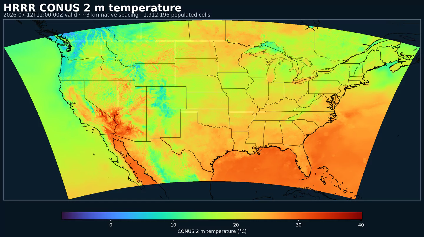
Representative HRRR coverage: 2 m temperature across the complete populated grid footprint at approximately 3 km spacing, with black state and country boundaries. This coverage reference was generated from hrrr for the hrrrsubh page; available variables may differ.
Description
HRRR Sub-hourly exposes high-frequency surface output from NOAA/NCEP's High-Resolution Rapid Refresh model. It is designed for workflows that care about intrahour ramps and sharp gradients: power markets (wind/solar ramp and load), aviation (winds, ceilings, visibility), and fast-evolving mesoscale weather.
This dataset is a focused subset of HRRR (the wrfsubhf product family): 15-minute valid times out to 18 hours . It is useful when an hourly value would hide a ramp, boundary, or short-lived surface signal.
For the full hourly HRRR archive, additional fields, and longer horizons, use HRRR . For analysis-style near-real-time surface fields rather than forecast valid times, compare with RTMA Rapid Update .
Detail
Archive begins: 2014-07-30Product page: https://www.nco.ncep.noaa.gov/pmb/products/hrrr/ Coverage: CONUS.Resolution: 3 km Lambert grid.Update cadence: Hourly cycles.Lead time: 0-18 hours with 15-minute valid times.Notes: Surface-focused subset; not a complete replacement for the full HRRR product.
Related datasets
HRRR for the full hourly model archiveRTMA Rapid Update for near-real-time surface analysisNBM for blended and postprocessed NOAA forecasts
Parameters
Click a parameter to reveal variants in a compact table with ready-to-copy JSON selectors.
APCP
– Accumulated Precipitation (kg/m^2)
1 variant
Accumulated precipitation represents the total water-equivalent amount of rain and snow during the output period. It is a primary field for hydrologic impacts and event totals.
Units: kg/m^2.
Use with the model time interval to interpret totals and compare to gauges.
Level
Info
Horizon
Introduced
Selector
surface0m-18h
2026-02-04
{"name":"APCP","level":"surface","info":""}
Copy
CFRZR
– Categorical Freezing Rain (flag)
1 variant
Categorical indicator of freezing rain occurrence at the surface during the output period.
Units: flag.
Useful as a mask for icing or glaze hazards.
Level
Info
Horizon
Introduced
Selector
surface0m-18h
2026-02-04
{"name":"CFRZR","level":"surface","info":""}
Copy
CICEP
– Categorical Ice Pellets (flag)
1 variant
Categorical indicator of ice pellet (sleet) occurrence at the surface during the output period.
Units: flag.
Use with precipitation fields to gauge intensity.
Level
Info
Horizon
Introduced
Selector
surface0m-18h
2026-02-04
{"name":"CICEP","level":"surface","info":""}
Copy
CPOFP
– Percent Frozen Precipitation (percent)
1 variant
Percent frozen precipitation indicates the fraction of total precipitation that is falling in frozen form. It helps distinguish mixed-phase and winter precipitation impacts.
Units: percent.
Higher values indicate a larger frozen contribution to the total precipitation.
Level
Info
Horizon
Introduced
Selector
surface0m-18h
2026-02-04
{"name":"CPOFP","level":"surface","info":""}
Copy
CRAIN
– Categorical Rain (flag)
1 variant
Categorical indicator of rain occurrence at the surface during the output period. Useful as a yes/no mask for rain.
Units: flag.
Use with accumulation or rate fields for intensity.
Level
Info
Horizon
Introduced
Selector
surface0m-18h
2026-02-04
{"name":"CRAIN","level":"surface","info":""}
Copy
CSNOW
– Categorical Snow (flag)
1 variant
Categorical indicator of snow occurrence at the surface during the output period.
Units: flag.
Use alongside snowfall/snow-water-equivalent fields.
Level
Info
Horizon
Introduced
Selector
surface0m-18h
2026-02-04
{"name":"CSNOW","level":"surface","info":""}
Copy
DLWRF
– Downward Longwave Radiation Flux (W/m^2)
1 variant
Downward longwave (thermal) flux represents incoming energy at the surface. It is a key driver of surface heating and cooling.
Units: W/m^2.
Shortwave affects surface heating; longwave affects radiative cooling.
Level
Info
Horizon
Introduced
Selector
surface0m-18h
2026-02-04
{"name":"DLWRF","level":"surface","info":""}
Copy
DPT
– Dew Point Temperature (K)
1 variant
Dew point temperature is the temperature at which the air becomes saturated. It is a direct measure of moisture content.
Units: K.
When dew point is close to air temperature, fog or low cloud potential increases.
Level
Info
Horizon
Introduced
Selector
2 m above ground0m-18h
2026-02-04
{"name":"DPT","level":"2 m above ground","info":""}
Copy
DSWRF
– Downward Short-Wave Radiation Flux (W/m^2)
1 variant
Downward radiative flux represents incoming energy at the surface. It is a key driver of surface heating and cooling.
Units: W/m^2.
Shortwave affects surface heating; longwave affects radiative cooling.
Level
Info
Horizon
Introduced
Selector
surface0m-18h
2026-02-04
{"name":"DSWRF","level":"surface","info":""}
Copy
FROZR
– Freezing Rain Accumulation (kg/m^2)
1 variant
Freezing rain accumulation is the water-equivalent amount of freezing rain during the period. It relates directly to ice accretion risk.
Units: kg/m^2.
Accumulations represent water-equivalent depth over the output interval; rates describe intensity.
Level
Info
Horizon
Introduced
Selector
surface0m-18h
2026-02-04
{"name":"FROZR","level":"surface","info":""}
Copy
GUST
– Wind Speed (Gust) (m/s)
1 variant
Wind gust is the peak short-duration wind speed. It captures brief, hazardous bursts that can exceed sustained winds.
Level
Info
Horizon
Introduced
Selector
surface0m-18h
2026-02-04
{"name":"GUST","level":"surface","info":""}
Copy
HGT
– Geopotential Height (gpm)
4 variants
Geopotential height is the altitude of a pressure surface in the atmosphere. It is the primary field for identifying ridges, troughs, and large‑scale flow patterns.
Level
Info
Horizon
Introduced
Selector
cloud base0m-18h
2026-02-04
{"name":"HGT","level":"cloud base","info":""}
Copy
cloud ceiling0m-18h
2026-02-04
{"name":"HGT","level":"cloud ceiling","info":""}
Copy
cloud top0m-18h
2026-02-04
{"name":"HGT","level":"cloud top","info":""}
Copy
surface0m-18h
2026-02-04
{"name":"HGT","level":"surface","info":""}
Copy
PRATE
– Precipitation Rate (kg/(m^2 s))
1 variant
Precipitation rate is the total intensity of precipitation over the period. It combines convective and stratiform contributions.
Units: kg/(m^2 s).
Accumulations represent water-equivalent depth over the output interval; rates describe intensity.
Level
Info
Horizon
Introduced
Selector
surface0m-18h
2026-02-04
{"name":"PRATE","level":"surface","info":""}
Copy
PRES
– Pressure (Pa)
1 variant
Pressure is the atmospheric pressure at the specified level. It is a fundamental mass-field variable for dynamics and thermodynamics.
Level
Info
Horizon
Introduced
Selector
surface0m-18h
2026-02-04
{"name":"PRES","level":"surface","info":""}
Copy
REFC
– Composite Reflectivity (dBZ)
1 variant
Composite reflectivity is the maximum reflectivity in the column. It is a standard radar‑style field for identifying convective cores and precipitation intensity.
Level
Info
Horizon
Introduced
Selector
entire atmosphere0m-18h
2026-02-04
{"name":"REFC","level":"entire atmosphere","info":""}
Copy
REFD
– Reflectivity (dBZ)
2 variants
Reflectivity is a radar‑style measure of hydrometeor concentration at a given level. Higher values generally correspond to heavier precipitation.
Level
Info
Horizon
Introduced
Selector
1000 m above ground0m-18h
2026-02-04
{"name":"REFD","level":"1000 m above ground","info":""}
Copy
4000 m above ground0m-18h
2026-02-04
{"name":"REFD","level":"4000 m above ground","info":""}
Copy
RETOP
– Radar Echo Top Height (m)
1 variant
Echo top height is the altitude of the highest reflectivity in the column. It is a proxy for storm depth and convective vigor.
Level
Info
Horizon
Introduced
Selector
cloud top0m-18h
2026-02-04
{"name":"RETOP","level":"cloud top","info":""}
Copy
SBT113
– Simulated Brightness Temperature for GOES 11, Channel 3 (K)
1 variant
Simulated brightness temperature for GOES-11 channel 3 represents modeled radiance converted to an equivalent blackbody temperature. It supports satellite comparison and cloud diagnostics.
Level
Info
Horizon
Introduced
Selector
top of atmosphere0m-18h
2026-02-04
{"name":"SBT113","level":"top of atmosphere","info":""}
Copy
SBT114
– Simulated Brightness Temperature for GOES 11, Channel 4 (K)
1 variant
Simulated brightness temperature for GOES-11 channel 4 represents modeled radiance converted to an equivalent blackbody temperature. It supports satellite comparison and cloud diagnostics.
Level
Info
Horizon
Introduced
Selector
top of atmosphere0m-18h
2026-02-04
{"name":"SBT114","level":"top of atmosphere","info":""}
Copy
SBT123
– Simulated Brightness Temperature for GOES 12, Channel 3 (K)
1 variant
Simulated brightness temperature for GOES-12 channel 3 represents modeled radiance converted to an equivalent blackbody temperature. It supports satellite comparison and cloud diagnostics.
Level
Info
Horizon
Introduced
Selector
top of atmosphere0m-18h
2026-02-04
{"name":"SBT123","level":"top of atmosphere","info":""}
Copy
SBT124
– Simulated Brightness Temperature for GOES 12, Channel 4 (K)
1 variant
Simulated brightness temperature for GOES-12 channel 4 represents modeled radiance converted to an equivalent blackbody temperature. It supports satellite comparison and cloud diagnostics.
Level
Info
Horizon
Introduced
Selector
top of atmosphere0m-18h
2026-02-04
{"name":"SBT124","level":"top of atmosphere","info":""}
Copy
SPFH
– Specific Humidity (kg/kg)
1 variant
Specific humidity is the mass of water vapor per mass of air at the specified level. It is central to moisture transport.
Units: kg/kg.
Higher values indicate more atmospheric moisture and greater cloud or precip potential.
Level
Info
Horizon
Introduced
Selector
2 m above ground0m-18h
2026-02-04
{"name":"SPFH","level":"2 m above ground","info":""}
Copy
TMP
– Temperature (K)
1 variant
Air temperature is the thermal state of the atmosphere at the specified level. It influences density, stability, and energy exchange.
Level
Info
Horizon
Introduced
Selector
2 m above ground0m-18h
2026-02-04
{"name":"TMP","level":"2 m above ground","info":""}
Copy
UGRD
– U-Component of Wind (m/s)
2 variants
U‑component of wind is the east‑west component of the horizontal wind. Combine with v for speed and direction.
Units: m/s.
Combine u and v components to compute speed and direction.
Level
Info
Horizon
Introduced
Selector
10 m above ground0m-18h
2026-02-04
{"name":"UGRD","level":"10 m above ground","info":""}
Copy
80 m above ground0m-18h
2026-02-04
{"name":"UGRD","level":"80 m above ground","info":""}
Copy
ULWRF
– Upward Longwave Radiation Flux (W/m^2)
2 variants
Upward longwave (thermal) flux represents outgoing energy at the surface. It is a key driver of surface heating and cooling.
Units: W/m^2.
Shortwave affects surface heating; longwave affects radiative cooling.
Level
Info
Horizon
Introduced
Selector
surface0m-18h
2026-02-04
{"name":"ULWRF","level":"surface","info":""}
Copy
top of atmosphere0m-18h
2026-02-04
{"name":"ULWRF","level":"top of atmosphere","info":""}
Copy
USWRF
– Upward Short-Wave Radiation Flux (W/m^2)
2 variants
Upward radiative flux represents outgoing energy at the surface. It is a key driver of surface heating and cooling.
Units: W/m^2.
Shortwave affects surface heating; longwave affects radiative cooling.
Level
Info
Horizon
Introduced
Selector
surface0m-18h
2026-02-04
{"name":"USWRF","level":"surface","info":""}
Copy
top of atmosphere0m-18h
2026-02-04
{"name":"USWRF","level":"top of atmosphere","info":""}
Copy
VBDSF
– Visible Beam Downward Solar Flux (W m-2)
1 variant
Visible beam downward solar flux is the direct visible sunlight at the surface. It is important for illumination and solar energy.
Level
Info
Horizon
Introduced
Selector
surface0m-18h
2026-02-04
{"name":"VBDSF","level":"surface","info":""}
Copy
VDDSF
– Visible Diffuse Downward Solar Flux (W m-2)
1 variant
Visible diffuse downward solar flux is the scattered visible light at the surface. It increases under clouds or aerosol loading.
Level
Info
Horizon
Introduced
Selector
surface0m-18h
2026-02-04
{"name":"VDDSF","level":"surface","info":""}
Copy
VGRD
– V-Component of Wind (m/s)
2 variants
V‑component of wind is the north‑south component of the horizontal wind. Combine with u for speed and direction.
Units: m/s.
Combine u and v components to compute speed and direction.
Level
Info
Horizon
Introduced
Selector
10 m above ground0m-18h
2026-02-04
{"name":"VGRD","level":"10 m above ground","info":""}
Copy
80 m above ground0m-18h
2026-02-04
{"name":"VGRD","level":"80 m above ground","info":""}
Copy
VIL
– Vertically-Integrated Liquid Water (kg/m^2)
1 variant
Vertically‑integrated liquid water is the total column liquid water content. It is used as a proxy for precipitation intensity and hail potential.
Level
Info
Horizon
Introduced
Selector
entire atmosphere0m-18h
2026-02-04
{"name":"VIL","level":"entire atmosphere","info":""}
Copy
VIS
– Visibility (m)
1 variant
Horizontal visibility at the surface. Lower values indicate reduced visibility due to fog, precipitation, or aerosols.
Level
Info
Horizon
Introduced
Selector
surface0m-18h
2026-02-04
{"name":"VIS","level":"surface","info":""}
Copy
WEASD
– Water Equivalent of Accumulated Snow Depth (kg/m^2)
1 variant
Snow water equivalent (SWE) is the total liquid water stored in the snowpack. It integrates depth and density of existing snow.
Units: kg/m^2.
Accumulations represent water-equivalent depth over the output interval; rates describe intensity.
Level
Info
Horizon
Introduced
Selector
surface0m-18h
2026-02-04
{"name":"WEASD","level":"surface","info":""}
Copy
WIND
– Wind Speed (m/s)
1 variant
Wind speed is the magnitude of the horizontal wind at the specified level. It is used for transport, mixing, and hazards.
Level
Info
Horizon
Introduced
Selector
10 m above ground0m-18h
2026-02-04
{"name":"WIND","level":"10 m above ground","info":""}
Copy
No parameters match your search.