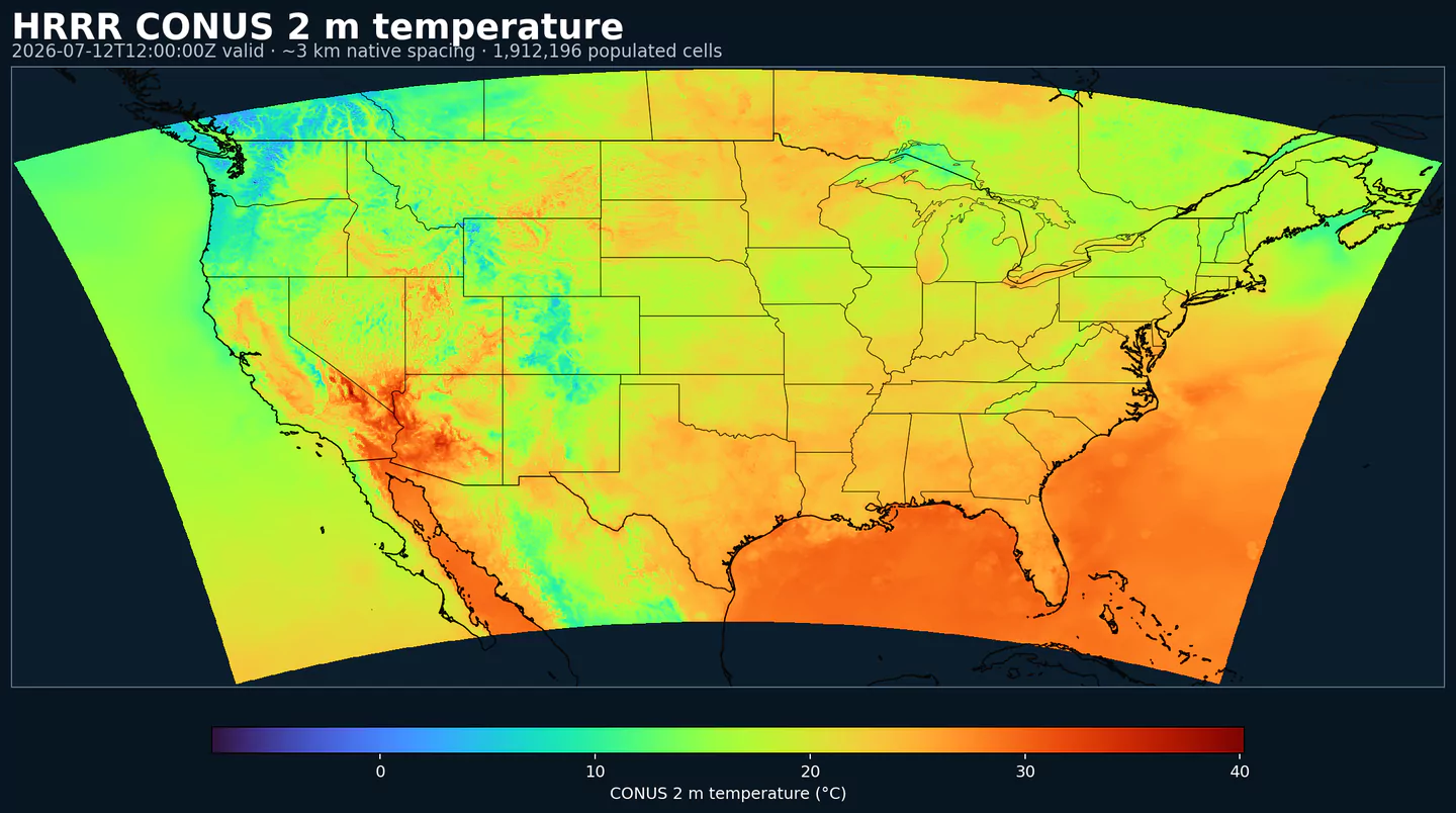
GribStream

HRRR Sub-hourly Surface Fields (CONUS)

Código GribStream: hrrrsubh

Descripción

HRRR Sub-hourly expone la salida de superficie de alta frecuencia del modelo High-Resolution Rapid Refresh de NOAA/NCEP para Estados Unidos continental.

El dataset hrrrsubh corresponde a la familia de productos wrfsubhf. Entrega tiempos válidos cada 15 minutos hasta 18 h, por lo que sirve cuando un valor horario ocultaría una rampa, un límite o un cambio de superficie de corta duración.

Es especialmente útil para productos que reaccionan a cambios dentro de la hora: mercados eléctricos, pronóstico de generación renovable, carga, vientos de aviación, techo de nubes, visibilidad y fenómenos de mesoescala de evolución rápida.

Para el archivo HRRR completo, con más campos y horizontes más largos, usa HRRR. Para campos de superficie de análisis casi en tiempo real, no tiempos válidos de pronóstico, compáralo con RTMA Rapid Update.

hrrrsubh es una vista enfocada, pensada para campos de superficie de muy corto plazo. No reemplaza al HRRR horario completo cuando necesitas niveles en altura, más variables o horizontes más largos.

Detalle

Datasets relacionados

Parámetros

0 parámetros

Haz clic en un parámetro para ver sus variantes en una tabla compacta con selectores JSON listos para copiar. Los códigos, niveles y valores de selector se mantienen exactamente como los expone la API.

APCP Accumulated Precipitation (kg/m^2)
1 variant

Accumulated precipitation represents the total water-equivalent amount of rain and snow during the output period. It is a primary field for hydrologic impacts and event totals.

  • Units: kg/m^2.
  • Use with the model time interval to interpret totals and compare to gauges.
Level Info Horizon Introduced Selector
surface 0m-18h 2026-02-04
{"name":"APCP","level":"surface","info":""}
CFRZR Categorical Freezing Rain (flag)
1 variant

Categorical indicator of freezing rain occurrence at the surface during the output period.

  • Units: flag.
  • Useful as a mask for icing or glaze hazards.
NOAA GRIB2 Table 4.222
Source
0
No
1
Yes
255
Missing
Level Info Horizon Introduced Selector
surface 0m-18h 2026-02-04
{"name":"CFRZR","level":"surface","info":""}
CICEP Categorical Ice Pellets (flag)
1 variant

Categorical indicator of ice pellet (sleet) occurrence at the surface during the output period.

  • Units: flag.
  • Use with precipitation fields to gauge intensity.
NOAA GRIB2 Table 4.222
Source
0
No
1
Yes
255
Missing
Level Info Horizon Introduced Selector
surface 0m-18h 2026-02-04
{"name":"CICEP","level":"surface","info":""}
CPOFP Percent Frozen Precipitation (percent)
1 variant

Percent frozen precipitation indicates the fraction of total precipitation that is falling in frozen form. It helps distinguish mixed-phase and winter precipitation impacts.

  • Units: percent.
  • Higher values indicate a larger frozen contribution to the total precipitation.
Level Info Horizon Introduced Selector
surface 0m-18h 2026-02-04
{"name":"CPOFP","level":"surface","info":""}
CRAIN Categorical Rain (flag)
1 variant

Categorical indicator of rain occurrence at the surface during the output period. Useful as a yes/no mask for rain.

  • Units: flag.
  • Use with accumulation or rate fields for intensity.
NOAA GRIB2 Table 4.222
Source
0
No
1
Yes
255
Missing
Level Info Horizon Introduced Selector
surface 0m-18h 2026-02-04
{"name":"CRAIN","level":"surface","info":""}
CSNOW Categorical Snow (flag)
1 variant

Categorical indicator of snow occurrence at the surface during the output period.

  • Units: flag.
  • Use alongside snowfall/snow-water-equivalent fields.
NOAA GRIB2 Table 4.222
Source
0
No
1
Yes
255
Missing
Level Info Horizon Introduced Selector
surface 0m-18h 2026-02-04
{"name":"CSNOW","level":"surface","info":""}
DLWRF Downward Longwave Radiation Flux (W/m^2)
1 variant

Downward longwave (thermal) flux represents incoming energy at the surface. It is a key driver of surface heating and cooling.

  • Units: W/m^2.
  • Shortwave affects surface heating; longwave affects radiative cooling.
Level Info Horizon Introduced Selector
surface 0m-18h 2026-02-04
{"name":"DLWRF","level":"surface","info":""}
DPT Dew Point Temperature (K)
1 variant

Dew point temperature is the temperature at which the air becomes saturated. It is a direct measure of moisture content.

  • Units: K.
  • When dew point is close to air temperature, fog or low cloud potential increases.
Level Info Horizon Introduced Selector
2 m above ground 0m-18h 2026-02-04
{"name":"DPT","level":"2 m above ground","info":""}
DSWRF Downward Short-Wave Radiation Flux (W/m^2)
1 variant

Downward radiative flux represents incoming energy at the surface. It is a key driver of surface heating and cooling.

  • Units: W/m^2.
  • Shortwave affects surface heating; longwave affects radiative cooling.
Level Info Horizon Introduced Selector
surface 0m-18h 2026-02-04
{"name":"DSWRF","level":"surface","info":""}
FROZR Freezing Rain Accumulation (kg/m^2)
1 variant

Freezing rain accumulation is the water-equivalent amount of freezing rain during the period. It relates directly to ice accretion risk.

  • Units: kg/m^2.
  • Accumulations represent water-equivalent depth over the output interval; rates describe intensity.
Level Info Horizon Introduced Selector
surface 0m-18h 2026-02-04
{"name":"FROZR","level":"surface","info":""}
GUST Wind Speed (Gust) (m/s)
1 variant

Wind gust is the peak short-duration wind speed. It captures brief, hazardous bursts that can exceed sustained winds.

  • Units: m/s.
Level Info Horizon Introduced Selector
surface 0m-18h 2026-02-04
{"name":"GUST","level":"surface","info":""}
HGT Geopotential Height (gpm)
4 variants

Geopotential height is the altitude of a pressure surface in the atmosphere. It is the primary field for identifying ridges, troughs, and large‑scale flow patterns.

  • Units: gpm.
Level Info Horizon Introduced Selector
cloud base 0m-18h 2026-02-04
{"name":"HGT","level":"cloud base","info":""}
cloud ceiling 0m-18h 2026-02-04
{"name":"HGT","level":"cloud ceiling","info":""}
cloud top 0m-18h 2026-02-04
{"name":"HGT","level":"cloud top","info":""}
surface 0m-18h 2026-02-04
{"name":"HGT","level":"surface","info":""}
PRATE Precipitation Rate (kg/(m^2 s))
1 variant

Precipitation rate is the total intensity of precipitation over the period. It combines convective and stratiform contributions.

  • Units: kg/(m^2 s).
  • Accumulations represent water-equivalent depth over the output interval; rates describe intensity.
Level Info Horizon Introduced Selector
surface 0m-18h 2026-02-04
{"name":"PRATE","level":"surface","info":""}
PRES Pressure (Pa)
1 variant

Pressure is the atmospheric pressure at the specified level. It is a fundamental mass-field variable for dynamics and thermodynamics.

  • Units: Pa.
Level Info Horizon Introduced Selector
surface 0m-18h 2026-02-04
{"name":"PRES","level":"surface","info":""}
REFC Composite Reflectivity (dBZ)
1 variant

Composite reflectivity is the maximum reflectivity in the column. It is a standard radar‑style field for identifying convective cores and precipitation intensity.

  • Units: dBZ.
Level Info Horizon Introduced Selector
entire atmosphere 0m-18h 2026-02-04
{"name":"REFC","level":"entire atmosphere","info":""}
REFD Reflectivity (dBZ)
2 variants

Reflectivity is a radar‑style measure of hydrometeor concentration at a given level. Higher values generally correspond to heavier precipitation.

  • Units: dBZ.
Level Info Horizon Introduced Selector
1000 m above ground 0m-18h 2026-02-04
{"name":"REFD","level":"1000 m above ground","info":""}
4000 m above ground 0m-18h 2026-02-04
{"name":"REFD","level":"4000 m above ground","info":""}
RETOP Radar Echo Top Height (m)
1 variant

Echo top height is the altitude of the highest reflectivity in the column. It is a proxy for storm depth and convective vigor.

  • Units: m.
Level Info Horizon Introduced Selector
cloud top 0m-18h 2026-02-04
{"name":"RETOP","level":"cloud top","info":""}
SBT113 Simulated Brightness Temperature for GOES 11, Channel 3 (K)
1 variant

Simulated brightness temperature for GOES-11 channel 3 represents modeled radiance converted to an equivalent blackbody temperature. It supports satellite comparison and cloud diagnostics.

  • Units: K.
Level Info Horizon Introduced Selector
top of atmosphere 0m-18h 2026-02-04
{"name":"SBT113","level":"top of atmosphere","info":""}
SBT114 Simulated Brightness Temperature for GOES 11, Channel 4 (K)
1 variant

Simulated brightness temperature for GOES-11 channel 4 represents modeled radiance converted to an equivalent blackbody temperature. It supports satellite comparison and cloud diagnostics.

  • Units: K.
Level Info Horizon Introduced Selector
top of atmosphere 0m-18h 2026-02-04
{"name":"SBT114","level":"top of atmosphere","info":""}
SBT123 Simulated Brightness Temperature for GOES 12, Channel 3 (K)
1 variant

Simulated brightness temperature for GOES-12 channel 3 represents modeled radiance converted to an equivalent blackbody temperature. It supports satellite comparison and cloud diagnostics.

  • Units: K.
Level Info Horizon Introduced Selector
top of atmosphere 0m-18h 2026-02-04
{"name":"SBT123","level":"top of atmosphere","info":""}
SBT124 Simulated Brightness Temperature for GOES 12, Channel 4 (K)
1 variant

Simulated brightness temperature for GOES-12 channel 4 represents modeled radiance converted to an equivalent blackbody temperature. It supports satellite comparison and cloud diagnostics.

  • Units: K.
Level Info Horizon Introduced Selector
top of atmosphere 0m-18h 2026-02-04
{"name":"SBT124","level":"top of atmosphere","info":""}
SPFH Specific Humidity (kg/kg)
1 variant

Specific humidity is the mass of water vapor per mass of air at the specified level. It is central to moisture transport.

  • Units: kg/kg.
  • Higher values indicate more atmospheric moisture and greater cloud or precip potential.
Level Info Horizon Introduced Selector
2 m above ground 0m-18h 2026-02-04
{"name":"SPFH","level":"2 m above ground","info":""}
TMP Temperature (K)
1 variant

Air temperature is the thermal state of the atmosphere at the specified level. It influences density, stability, and energy exchange.

  • Units: K.
Level Info Horizon Introduced Selector
2 m above ground 0m-18h 2026-02-04
{"name":"TMP","level":"2 m above ground","info":""}
UGRD U-Component of Wind (m/s)
2 variants

U‑component of wind is the east‑west component of the horizontal wind. Combine with v for speed and direction.

  • Units: m/s.
  • Combine u and v components to compute speed and direction.
Level Info Horizon Introduced Selector
10 m above ground 0m-18h 2026-02-04
{"name":"UGRD","level":"10 m above ground","info":""}
80 m above ground 0m-18h 2026-02-04
{"name":"UGRD","level":"80 m above ground","info":""}
ULWRF Upward Longwave Radiation Flux (W/m^2)
2 variants

Upward longwave (thermal) flux represents outgoing energy at the surface. It is a key driver of surface heating and cooling.

  • Units: W/m^2.
  • Shortwave affects surface heating; longwave affects radiative cooling.
Level Info Horizon Introduced Selector
surface 0m-18h 2026-02-04
{"name":"ULWRF","level":"surface","info":""}
top of atmosphere 0m-18h 2026-02-04
{"name":"ULWRF","level":"top of atmosphere","info":""}
USWRF Upward Short-Wave Radiation Flux (W/m^2)
2 variants

Upward radiative flux represents outgoing energy at the surface. It is a key driver of surface heating and cooling.

  • Units: W/m^2.
  • Shortwave affects surface heating; longwave affects radiative cooling.
Level Info Horizon Introduced Selector
surface 0m-18h 2026-02-04
{"name":"USWRF","level":"surface","info":""}
top of atmosphere 0m-18h 2026-02-04
{"name":"USWRF","level":"top of atmosphere","info":""}
VBDSF Visible Beam Downward Solar Flux (W m-2)
1 variant

Visible beam downward solar flux is the direct visible sunlight at the surface. It is important for illumination and solar energy.

  • Units: W m-2.
Level Info Horizon Introduced Selector
surface 0m-18h 2026-02-04
{"name":"VBDSF","level":"surface","info":""}
VDDSF Visible Diffuse Downward Solar Flux (W m-2)
1 variant

Visible diffuse downward solar flux is the scattered visible light at the surface. It increases under clouds or aerosol loading.

  • Units: W m-2.
Level Info Horizon Introduced Selector
surface 0m-18h 2026-02-04
{"name":"VDDSF","level":"surface","info":""}
VGRD V-Component of Wind (m/s)
2 variants

V‑component of wind is the north‑south component of the horizontal wind. Combine with u for speed and direction.

  • Units: m/s.
  • Combine u and v components to compute speed and direction.
Level Info Horizon Introduced Selector
10 m above ground 0m-18h 2026-02-04
{"name":"VGRD","level":"10 m above ground","info":""}
80 m above ground 0m-18h 2026-02-04
{"name":"VGRD","level":"80 m above ground","info":""}
VIL Vertically-Integrated Liquid Water (kg/m^2)
1 variant

Vertically‑integrated liquid water is the total column liquid water content. It is used as a proxy for precipitation intensity and hail potential.

  • Units: kg/m^2.
Level Info Horizon Introduced Selector
entire atmosphere 0m-18h 2026-02-04
{"name":"VIL","level":"entire atmosphere","info":""}
VIS Visibility (m)
1 variant

Horizontal visibility at the surface. Lower values indicate reduced visibility due to fog, precipitation, or aerosols.

  • Units: m.
Level Info Horizon Introduced Selector
surface 0m-18h 2026-02-04
{"name":"VIS","level":"surface","info":""}
WEASD Water Equivalent of Accumulated Snow Depth (kg/m^2)
1 variant

Snow water equivalent (SWE) is the total liquid water stored in the snowpack. It integrates depth and density of existing snow.

  • Units: kg/m^2.
  • Accumulations represent water-equivalent depth over the output interval; rates describe intensity.
Level Info Horizon Introduced Selector
surface 0m-18h 2026-02-04
{"name":"WEASD","level":"surface","info":""}
WIND Wind Speed (m/s)
1 variant

Wind speed is the magnitude of the horizontal wind at the specified level. It is used for transport, mixing, and hazards.

  • Units: m/s.
Level Info Horizon Introduced Selector
10 m above ground 0m-18h 2026-02-04
{"name":"WIND","level":"10 m above ground","info":""}

Ningún parámetro coincide con la búsqueda.