Código GribStream: ifsoper
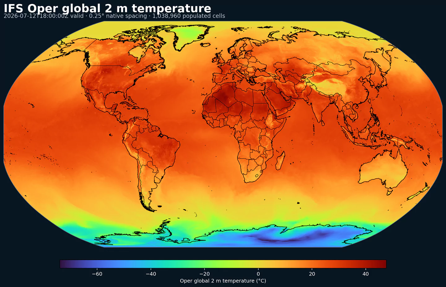
IFS Oper 2 m temperature across its complete 0.25 degree global grid, with black country boundaries. This plot was generated from the ifsoper dataset.
Descripción
IFS Oper (ECMWF IFS HRES) es el sistema global de predicción numérica de ECMWF para mediano plazo. Acopla atmósfera, océano, superficie terrestre y hielo marino en un único modelo físico.
El análisis usa 4D-Var con Ensemble of Data Assimilations para estimar errores de fondo que cambian con el flujo atmosférico. Asimila radiancias satelitales, ocultación GNSS, vientos de dispersómetro (scatterometer) y altímetro, observaciones de aeronaves, radiosondeos, observaciones de superficie, boyas y barcos.
Los campos de pronóstico incluyen temperatura, viento, humedad, precipitación, nubosidad, radiación, presión y un conjunto amplio de variables de superficie y niveles de presión.
En GribStream, ifsoper es una buena referencia global de alta calidad para productos de mediano plazo. Está estrechamente relacionado con el ensemble IFS ENS y el modelo de oleaje IFS Wave .
Detalle
Archivo desde: 2024-02-28Página del producto: https://www.ecmwf.int/en/forecasts/datasets/open-data Características principales:
Sistema global físico de ECMWF para pronóstico determinístico de mediano plazo.
Acopla atmósfera, océano, superficie terrestre y hielo marino en un único modelo.
Usa 4D-Var y Ensemble of Data Assimilations para estimar errores de fondo que cambian con el flujo atmosférico.
Pasos de 3 h hasta 144 h y de 6 h desde 150 h hasta 360 h.
Resolución: Grilla global de 0.25 grados, aproximadamente 28 km, en el subconjunto open data.Cobertura temporal: Cuatro ciclos por día: 00, 06, 12 y 18 UTC.Usos principales: Pronóstico de mediano plazo, rutas aéreas y marítimas, energía renovable, agricultura, logística y benchmarking (comparación de referencia) entre modelos.
Datasets relacionados
Parámetros
Haz clic en un parámetro para ver sus variantes en una tabla compacta con selectores JSON listos para copiar. Los códigos, niveles y valores de selector se mantienen exactamente como los expone la API.
100u
– 100 metre U wind component (m s-1)
1 variant
Eastward component of the 100 m wind, describing near-surface flow aloft.
Comparisons to observations require care because observations represent point measurements rather than grid-box means.
Combine with the 100 m V component to derive wind speed and direction.
Level
Info
Horizon
Introduced
Selector
sfc0h-360h
2024-03-05
{"name":"100u","level":"sfc","info":""}
Copy
100v
– 100 metre V wind component (m s-1)
1 variant
Northward component of the 100 m wind, describing near-surface flow aloft.
Comparisons to observations require care because observations represent point measurements rather than grid-box means.
Combine with the 100 m U component to derive wind speed and direction.
Level
Info
Horizon
Introduced
Selector
sfc0h-360h
2024-03-05
{"name":"100v","level":"sfc","info":""}
Copy
10fg
– Maximum 10 metre wind gust since previous post-processing (m s-1)
1 variant
Maximum 3‑second wind gust at 10 m height since the last post-processing step.
Convection effects are included after 2008-10-01; before that, only turbulence is represented.
Gusts are evaluated each time step and the maximum retained since the last post-processing.
Level
Info
Horizon
Introduced
Selector
sfc0h-360h
2024-11-12
{"name":"10fg","level":"sfc","info":""}
Copy
10fg3
– Maximum 10 metre wind gust in the last 3 hours (m s-1)
1 variant
Maximum 3‑second wind gust at 10 m height over the previous 3 hours.
ECMWF estimates gusts within each time step using surface stress, friction, wind shear, and stability, then selects the maximum over the 3‑hour window.
Comparisons to observations require care because observations are point measurements.
Level
Info
Horizon
Introduced
Selector
sfc93h-144h
2024-11-12
{"name":"10fg3","level":"sfc","info":""}
Copy
10u
– 10 metre U wind component (m s-1)
1 variant
Eastward (U) component of near-surface wind.
Combine with the 10 m V component to derive wind speed and direction.
Observations can diverge due to terrain, vegetation, and local exposure.
Level
Info
Horizon
Introduced
Selector
sfc0h-360h
2024-03-01
{"name":"10u","level":"sfc","info":""}
Copy
10v
– 10 metre V wind component (m s-1)
1 variant
Northward (V) component of near-surface wind.
Combine with the 10 m U component to derive wind speed and direction.
Observations can diverge due to terrain, vegetation, and local exposure.
Level
Info
Horizon
Introduced
Selector
sfc0h-360h
2024-03-01
{"name":"10v","level":"sfc","info":""}
Copy
2d
– 2 metre dewpoint temperature (K)
1 variant
Dewpoint temperature describing near-surface moisture conditions. Useful for humidity diagnostics.
Often combined with temperature and pressure to estimate relative humidity.
Computed by interpolating between the lowest model level and the surface.
Level
Info
Horizon
Introduced
Selector
sfc0h-360h
2024-03-05
{"name":"2d","level":"sfc","info":""}
Copy
2t
– 2 metre temperature (K)
1 variant
Near-surface air temperature representative of conditions over land, sea, or inland waters. Derived using surface and lowest model level information.
Units are kelvin (K); to convert to degrees Celsius (deg C), subtract 273.15.
Mean 2 metre temperature is encoded separately (parameter 228004).
Level
Info
Horizon
Introduced
Selector
sfc0h-360h
2024-03-01
{"name":"2t","level":"sfc","info":""}
Copy
asn
– Snow albedo ((0 - 1))
1 variant
Fraction of incoming shortwave radiation reflected by the snow-covered part of a grid box.
IFS represents snow as a single layer above the uppermost soil level.
Albedo varies with snow age and vegetation; typical ranges span 0.52–0.88 for low vegetation and 0.27–0.38 for high vegetation with snow underneath.
See parameter 228032 for the equivalent value expressed in percent.
Level
Info
Horizon
Introduced
Selector
sfc0h-360h
2024-03-05
{"name":"asn","level":"sfc","info":""}
Copy
d
– Divergence (s-1)
14 variants
Horizontal divergence of velocity, indicating spreading or convergence of airflow.
Positive values indicate divergence (air spreading out); negative values indicate convergence.
Level
Info
Horizon
Introduced
Selector
pl 100h-360h
2026-05-12
{"name":"d","level":"pl 10","info":""}
Copy
pl 1000h-360h
2024-03-05
{"name":"d","level":"pl 100","info":""}
Copy
pl 10000h-360h
2024-03-01
{"name":"d","level":"pl 1000","info":""}
Copy
pl 1500h-360h
2024-03-05
{"name":"d","level":"pl 150","info":""}
Copy
pl 2000h-360h
2024-03-01
{"name":"d","level":"pl 200","info":""}
Copy
pl 2500h-360h
2024-03-01
{"name":"d","level":"pl 250","info":""}
Copy
pl 3000h-360h
2024-03-01
{"name":"d","level":"pl 300","info":""}
Copy
pl 4000h-360h
2024-03-05
{"name":"d","level":"pl 400","info":""}
Copy
pl 500h-360h
2024-03-01
{"name":"d","level":"pl 50","info":""}
Copy
pl 5000h-360h
2024-03-01
{"name":"d","level":"pl 500","info":""}
Copy
pl 6000h-360h
2024-03-05
{"name":"d","level":"pl 600","info":""}
Copy
pl 7000h-360h
2024-03-01
{"name":"d","level":"pl 700","info":""}
Copy
pl 8500h-360h
2024-03-01
{"name":"d","level":"pl 850","info":""}
Copy
pl 9250h-360h
2024-03-01
{"name":"d","level":"pl 925","info":""}
Copy
ewss
– Time-integrated eastward turbulent surface stress (N m-2 s)
1 variant
Accumulated eastward surface stress from turbulent atmosphere–surface interactions and sub‑5 km orographic form drag.
Positive values denote stress toward the east; negative values denote westward stress.
Accumulated over the integration period of the extracted data.
Level
Info
Horizon
Introduced
Selector
sfc0h-360h
2024-11-12
{"name":"ewss","level":"sfc","info":""}
Copy
gh
– Geopotential height (gpm)
14 variants
Height derived from geopotential divided by standard gravity (9.80665 m s-2).
Used on constant pressure levels to diagnose synoptic features (e.g., troughs, ridges, cyclones).
At the surface, it reflects orography (geopotential height of the surface).
A geopotential metre is approximately 2% shorter than a geometric metre.
Level
Info
Horizon
Introduced
Selector
pl 100h-360h
2026-05-12
{"name":"gh","level":"pl 10","info":""}
Copy
pl 1000h-360h
2024-03-05
{"name":"gh","level":"pl 100","info":""}
Copy
pl 10000h-360h
2024-03-01
{"name":"gh","level":"pl 1000","info":""}
Copy
pl 1500h-360h
2024-03-05
{"name":"gh","level":"pl 150","info":""}
Copy
pl 2000h-360h
2024-03-01
{"name":"gh","level":"pl 200","info":""}
Copy
pl 2500h-360h
2024-03-01
{"name":"gh","level":"pl 250","info":""}
Copy
pl 3000h-360h
2024-03-01
{"name":"gh","level":"pl 300","info":""}
Copy
pl 4000h-360h
2024-03-05
{"name":"gh","level":"pl 400","info":""}
Copy
pl 500h-360h
2024-03-01
{"name":"gh","level":"pl 50","info":""}
Copy
pl 5000h-360h
2024-03-01
{"name":"gh","level":"pl 500","info":""}
Copy
pl 6000h-360h
2024-03-05
{"name":"gh","level":"pl 600","info":""}
Copy
pl 7000h-360h
2024-03-01
{"name":"gh","level":"pl 700","info":""}
Copy
pl 8500h-360h
2024-03-01
{"name":"gh","level":"pl 850","info":""}
Copy
pl 9250h-360h
2024-03-01
{"name":"gh","level":"pl 925","info":""}
Copy
lsm
– Land-sea mask ((0 - 1))
1 variant
Fraction of land within a grid box relative to ocean and inland waters.
Values range from 0 to 1 and are dimensionless.
From IFS CY41R1 (May 2015), grid boxes >0.5 may mix land and inland water; <=0.5 are water only.
Before CY41R1, >0.5 implied land only; <=0.5 implied ocean only (no inland water differentiation).
Level
Info
Horizon
Introduced
Selector
sfc0h-360h
2024-03-01
{"name":"lsm","level":"sfc","info":""}
Copy
mn2t3
– Minimum temperature at 2 metres in the last 3 hours (K)
1 variant
Lowest 2 m temperature observed over the previous 3 hours.
2 m temperature is derived by interpolating between the lowest model level and the surface.
Units are kelvin (K); to convert to degrees Celsius (deg C), subtract 273.15.
Level
Info
Horizon
Introduced
Selector
sfc3h-144h
2024-09-17
{"name":"mn2t3","level":"sfc","info":""}
Copy
mn2t6
– Minimum temperature at 2 metres in the last 6 hours (K)
1 variant
Lowest 2 m temperature observed over the previous 6 hours.
2 m temperature is derived by interpolating between the lowest model level and the surface.
Units are kelvin (K); to convert to degrees Celsius (deg C), subtract 273.15.
Level
Info
Horizon
Introduced
Selector
sfc150h-360h
2024-03-05
{"name":"mn2t6","level":"sfc","info":""}
Copy
msl
– Mean sea level pressure (Pa)
1 variant
Atmospheric pressure adjusted to mean sea level, reflecting the weight of the air column.
Maps of mean sea level pressure highlight cyclones, anticyclones, and wind strength via contour spacing.
Often expressed in hPa or millibars (1 hPa = 1 mb = 100 Pa).
Level
Info
Horizon
Introduced
Selector
sfc0h-360h
2024-03-01
{"name":"msl","level":"sfc","info":""}
Copy
mucape
– Most-unstable CAPE (J kg-1)
1 variant
Convective Available Potential Energy for the most unstable parcel in the layer from the surface to 350 hPa.
Relates to maximum potential updraft velocity.
In the lowest 60 hPa, 30‑hPa mixed‑layer parameters are used.
Level
Info
Horizon
Introduced
Selector
sfc0h-360h
2024-11-12
{"name":"mucape","level":"sfc","info":""}
Copy
mx2t3
– Maximum temperature at 2 metres in the last 3 hours (K)
1 variant
Highest 2 m temperature observed over the previous 3 hours.
2 m temperature is derived by interpolating between the lowest model level and the surface.
Units are kelvin (K); to convert to degrees Celsius (deg C), subtract 273.15.
Level
Info
Horizon
Introduced
Selector
sfc3h-144h
2024-09-17
{"name":"mx2t3","level":"sfc","info":""}
Copy
mx2t6
– Maximum temperature at 2 metres in the last 6 hours (K)
1 variant
Highest 2 m temperature observed over the previous 6 hours.
2 m temperature is derived by interpolating between the lowest model level and the surface.
Units are kelvin (K); to convert to degrees Celsius (deg C), subtract 273.15.
Level
Info
Horizon
Introduced
Selector
sfc150h-360h
2024-03-05
{"name":"mx2t6","level":"sfc","info":""}
Copy
nsss
– Time-integrated northward turbulent surface stress (N m-2 s)
1 variant
Accumulated northward surface stress from turbulent atmosphere–surface interactions and sub‑5 km orographic form drag.
Positive values denote stress toward the north; negative values denote southward stress.
Accumulated over the integration period of the extracted data.
Level
Info
Horizon
Introduced
Selector
sfc0h-360h
2024-11-12
{"name":"nsss","level":"sfc","info":""}
Copy
ptype
– Precipitation type (Code table 4.201)
1 variant
Surface precipitation type derived from predicted rain and snow fields plus atmospheric conditions.
Use alongside precipitation rate to flag events such as freezing rain.
IFS codes: 0 none, 1 rain, 3 freezing rain, 5 snow, 6 wet snow, 7 rain/snow mix, 8 ice pellets, 12 freezing drizzle.
IFS does not diagnose WMO codes 2, 4, 9, 10, 11.
Level
Info
Horizon
Introduced
Selector
sfc0h-360h
2024-11-12
{"name":"ptype","level":"sfc","info":""}
Copy
q
– Specific humidity (kg kg-1)
14 variants
Mass of water vapour per kilogram of moist air.
Moist air includes dry air, water vapour, cloud liquid, cloud ice, rain, and falling snow.
Level
Info
Horizon
Introduced
Selector
pl 100h-360h
2026-05-12
{"name":"q","level":"pl 10","info":""}
Copy
pl 1000h-360h
2024-03-05
{"name":"q","level":"pl 100","info":""}
Copy
pl 10000h-360h
2024-03-01
{"name":"q","level":"pl 1000","info":""}
Copy
pl 1500h-360h
2024-03-05
{"name":"q","level":"pl 150","info":""}
Copy
pl 2000h-360h
2024-03-01
{"name":"q","level":"pl 200","info":""}
Copy
pl 2500h-360h
2024-03-01
{"name":"q","level":"pl 250","info":""}
Copy
pl 3000h-360h
2024-03-01
{"name":"q","level":"pl 300","info":""}
Copy
pl 4000h-360h
2024-03-05
{"name":"q","level":"pl 400","info":""}
Copy
pl 500h-360h
2024-03-01
{"name":"q","level":"pl 50","info":""}
Copy
pl 5000h-360h
2024-03-01
{"name":"q","level":"pl 500","info":""}
Copy
pl 6000h-360h
2024-03-05
{"name":"q","level":"pl 600","info":""}
Copy
pl 7000h-360h
2024-03-01
{"name":"q","level":"pl 700","info":""}
Copy
pl 8500h-360h
2024-03-01
{"name":"q","level":"pl 850","info":""}
Copy
pl 9250h-360h
2024-03-01
{"name":"q","level":"pl 925","info":""}
Copy
r
– Relative humidity (%)
14 variants
Water vapour pressure as a percentage of saturation.
For temperatures >0°C, saturation is over water; below -23°C, over ice.
Between -23°C and 0°C, values are interpolated between ice and water using a quadratic function.
Level
Info
Horizon
Introduced
Selector
pl 100h-360h
2026-05-12
{"name":"r","level":"pl 10","info":""}
Copy
pl 1000h-360h
2024-03-05
{"name":"r","level":"pl 100","info":""}
Copy
pl 10000h-360h
2024-03-01
{"name":"r","level":"pl 1000","info":""}
Copy
pl 1500h-360h
2024-03-05
{"name":"r","level":"pl 150","info":""}
Copy
pl 2000h-360h
2024-03-01
{"name":"r","level":"pl 200","info":""}
Copy
pl 2500h-360h
2024-03-01
{"name":"r","level":"pl 250","info":""}
Copy
pl 3000h-360h
2024-03-01
{"name":"r","level":"pl 300","info":""}
Copy
pl 4000h-360h
2024-03-05
{"name":"r","level":"pl 400","info":""}
Copy
pl 500h-360h
2024-03-01
{"name":"r","level":"pl 50","info":""}
Copy
pl 5000h-360h
2024-03-01
{"name":"r","level":"pl 500","info":""}
Copy
pl 6000h-360h
2024-03-05
{"name":"r","level":"pl 600","info":""}
Copy
pl 7000h-360h
2024-03-01
{"name":"r","level":"pl 700","info":""}
Copy
pl 8500h-360h
2024-03-01
{"name":"r","level":"pl 850","info":""}
Copy
pl 9250h-360h
2024-03-01
{"name":"r","level":"pl 925","info":""}
Copy
ro
– Runoff (m)
1 variant
Total surface + subsurface runoff accumulated over the output period, expressed as equivalent water depth.
Useful as a drought or flood indicator; comparisons to observations require care due to scale and unit differences.
See parameter 231002 for the equivalent value expressed in kg m-2.
Level
Info
Horizon
Introduced
Selector
sfc0h-360h
2024-03-01
{"name":"ro","level":"sfc","info":""}
Copy
rsn
– Snow density (kg m-3)
1 variant
Mass of snow per cubic metre in the model snow layer.
The IFS represents snow as a layer over the uppermost soil level, with snow covering all or part of a grid box.
Level
Info
Horizon
Introduced
Selector
sfc0h-360h
2026-02-11
{"name":"rsn","level":"sfc","info":""}
Copy
sd
– Snow depth (m of water equivalent)
1 variant
Depth of snow expressed as the equivalent depth of water if the snow melted.
Represents snow over the snow-covered part of the grid box.
See parameter 228141 for the equivalent value expressed in kg m-2.
Level
Info
Horizon
Introduced
Selector
sfc0h-360h
2025-12-03
{"name":"sd","level":"sfc","info":""}
Copy
sdor
– Standard deviation of sub-gridscale orography (m)
1 variant
Standard deviation of sub-grid orography within a grid box (valleys, hills, and mountains below model resolution).
Derived from ~1 km land-surface data for features between 5 km and the model grid resolution.
Used by the sub-grid orography scheme for low-level blocking and gravity-wave drag.
Level
Info
Horizon
Introduced
Selector
sfc0h
2024-12-03
{"name":"sdor","level":"sfc","info":""}
Copy
sf
– Snowfall (m of water equivalent)
1 variant
Accumulated snowfall at the surface (large-scale + convective).
Accumulated over the extraction period; depth in metres of water equivalent.
See parameter 228144 for the equivalent value expressed in kg m-2.
Level
Info
Horizon
Introduced
Selector
sfc0h-360h
2025-12-03
{"name":"sf","level":"sfc","info":""}
Copy
sithick
– Sea-ice thickness (m)
1 variant
Thickness of sea ice within a grid box.
Level
Info
Horizon
Introduced
Selector
sfc0h-360h
2024-11-12
{"name":"sithick","level":"sfc","info":""}
Copy
skt
– Skin temperature (K)
1 variant
Temperature of the Earth's surface required to satisfy the surface energy balance.
Represents the uppermost surface layer with no heat capacity, so it responds instantly to surface flux changes.
Computed differently over land and sea.
Units are kelvin (K); to convert to degrees Celsius (deg C), subtract 273.15.
Mean skin temperature is encoded separately (parameter 235079).
Level
Info
Horizon
Introduced
Selector
sfc0h-360h
2024-03-01
{"name":"skt","level":"sfc","info":""}
Copy
slor
– Slope of sub-gridscale orography (Numeric)
1 variant
Slope metric for sub-grid orography derived from ~1 km terrain data.
Represents slopes of valleys, hills, and mountains unresolved by the model grid.
A flat surface has value 0; a 45° slope corresponds to 0.5.
Level
Info
Horizon
Introduced
Selector
sfc0h
2024-12-03
{"name":"slor","level":"sfc","info":""}
Copy
sot
– Soil temperature (K)
4 variants
Soil temperature.
Level
Info
Horizon
Introduced
Selector
sol 10h-360h
2024-11-12
{"name":"sot","level":"sol 1","info":""}
Copy
sol 20h-360h
2024-11-12
{"name":"sot","level":"sol 2","info":""}
Copy
sol 30h-360h
2024-11-12
{"name":"sot","level":"sol 3","info":""}
Copy
sol 40h-360h
2024-11-12
{"name":"sot","level":"sol 4","info":""}
Copy
sp
– Surface pressure (Pa)
1 variant
Atmospheric pressure at the surface of land, sea, and inland water.
Often used with temperature to estimate air density.
Mean sea level pressure is typically preferred for identifying large-scale pressure systems in mountainous regions.
Often expressed in hPa or millibars (1 hPa = 1 mb = 100 Pa).
Level
Info
Horizon
Introduced
Selector
sfc0h-360h
2024-03-01
{"name":"sp","level":"sfc","info":""}
Copy
ssr
– Surface net short-wave (solar) radiation (J m-2)
1 variant
Net shortwave radiation at the surface (downward minus reflected).
Depends on surface albedo and atmospheric absorption/scattering.
Accumulated over the extraction period; divide by seconds to convert to W m-2.
ECMWF convention for vertical fluxes is positive downward.
Level
Info
Horizon
Introduced
Selector
sfc0h-360h
2024-03-05
{"name":"ssr","level":"sfc","info":""}
Copy
ssrd
– Surface short-wave (solar) radiation downwards (J m-2)
1 variant
Downward shortwave radiation at the surface (direct + diffuse).
Approximate model equivalent of pyranometer measurements.
Accumulated over the extraction period; divide by seconds to convert to W m-2.
ECMWF convention for vertical fluxes is positive downward.
Level
Info
Horizon
Introduced
Selector
sfc0h-360h
2024-03-05
{"name":"ssrd","level":"sfc","info":""}
Copy
str
– Surface net long-wave (thermal) radiation (J m-2)
1 variant
Net longwave radiation at the surface (downward minus upward).
Includes atmospheric and cloud emission to the surface and surface emission/reflectance upward.
Accumulated over the extraction period; divide by seconds to convert to W m-2.
ECMWF convention for vertical fluxes is positive downward.
Level
Info
Horizon
Introduced
Selector
sfc0h-360h
2024-03-05
{"name":"str","level":"sfc","info":""}
Copy
strd
– Surface long-wave (thermal) radiation downwards (J m-2)
1 variant
Downward longwave radiation at the surface emitted by the atmosphere and clouds.
Accumulated over the extraction period; divide by seconds to convert to W m-2.
ECMWF convention for vertical fluxes is positive downward.
Level
Info
Horizon
Introduced
Selector
sfc0h-360h
2024-03-05
{"name":"strd","level":"sfc","info":""}
Copy
sve
– Eastward surface sea water velocity (m s-1)
1 variant
Eastward component of surface sea water velocity.
Level
Info
Horizon
Introduced
Selector
sfc0h-360h
2024-11-12
{"name":"sve","level":"sfc","info":""}
Copy
svn
– Northward surface sea water velocity (m s-1)
1 variant
Northward component of surface sea water velocity.
Level
Info
Horizon
Introduced
Selector
sfc0h-360h
2024-11-12
{"name":"svn","level":"sfc","info":""}
Copy
t
– Temperature (K)
14 variants
Air temperature throughout the atmosphere.
Units are kelvin (K); to convert to degrees Celsius (deg C), subtract 273.15.
Available on multiple vertical levels.
Level
Info
Horizon
Introduced
Selector
pl 100h-360h
2026-05-12
{"name":"t","level":"pl 10","info":""}
Copy
pl 1000h-360h
2024-03-05
{"name":"t","level":"pl 100","info":""}
Copy
pl 10000h-360h
2024-03-01
{"name":"t","level":"pl 1000","info":""}
Copy
pl 1500h-360h
2024-03-05
{"name":"t","level":"pl 150","info":""}
Copy
pl 2000h-360h
2024-03-01
{"name":"t","level":"pl 200","info":""}
Copy
pl 2500h-360h
2024-03-01
{"name":"t","level":"pl 250","info":""}
Copy
pl 3000h-360h
2024-03-01
{"name":"t","level":"pl 300","info":""}
Copy
pl 4000h-360h
2024-03-05
{"name":"t","level":"pl 400","info":""}
Copy
pl 500h-360h
2024-03-01
{"name":"t","level":"pl 50","info":""}
Copy
pl 5000h-360h
2024-03-01
{"name":"t","level":"pl 500","info":""}
Copy
pl 6000h-360h
2024-03-05
{"name":"t","level":"pl 600","info":""}
Copy
pl 7000h-360h
2024-03-01
{"name":"t","level":"pl 700","info":""}
Copy
pl 8500h-360h
2024-03-01
{"name":"t","level":"pl 850","info":""}
Copy
pl 9250h-360h
2024-03-01
{"name":"t","level":"pl 925","info":""}
Copy
tcc
– Total cloud cover ((0 - 1))
1 variant
Fraction of a grid box covered by cloud across all model levels.
Computed from cloud across different heights with overlap assumptions.
See parameter 228164 for the equivalent value in percent.
Level
Info
Horizon
Introduced
Selector
sfc0h-360h
2025-12-03
{"name":"tcc","level":"sfc","info":""}
Copy
tcw
– Total column water (kg m-2)
1 variant
Total column water including vapour, liquid water, cloud ice, rain, and snow.
Older IFS versions did not include rain and snow in the total.
Level
Info
Horizon
Introduced
Selector
sfc0h-360h
2024-10-24
{"name":"tcw","level":"sfc","info":""}
Copy
tcwv
– Total column vertically-integrated water vapour (kg m-2)
1 variant
Total water vapour in a column from the surface to the top of the atmosphere.
Represents a grid-box mean value.
Level
Info
Horizon
Introduced
Selector
sfc0h-360h
2024-03-01
{"name":"tcwv","level":"sfc","info":""}
Copy
tp
– Total precipitation (m)
1 variant
Accumulated rain + snow at the surface (large-scale + convective).
Does not include fog, dew, or precipitation that evaporates before reaching the surface.
Accumulated over the extraction period; depth in metres of water equivalent.
See parameter 228228 for the equivalent value expressed in kg m-2.
Level
Info
Horizon
Introduced
Selector
sfc0h-360h
2024-03-01
{"name":"tp","level":"sfc","info":""}
Copy
tprate
– Time-mean total precipitation rate (m s-1)
1 variant
Mean rate of total precipitation (accumulated precipitation divided by the accumulation period).
Total precipitation includes large-scale + convective rain and snow; excludes fog, dew, and precipitation that evaporates before reaching the surface.
Units represent depth of water equivalent per second.
Comparisons to observations require care due to spatial and temporal scale differences.
Level
Info
Horizon
Introduced
Selector
sfc0h-360h
2024-11-12
{"name":"tprate","level":"sfc","info":""}
Copy
ttr
– Top net long-wave (thermal) radiation (J m-2)
1 variant
Net longwave radiation at the top of the atmosphere (negative of OLR).
Accumulated over the extraction period; divide by seconds to convert to W m-2.
ECMWF convention for vertical fluxes is positive downward.
Level
Info
Horizon
Introduced
Selector
sfc0h-360h
2024-03-05
{"name":"ttr","level":"sfc","info":""}
Copy
u
– U component of wind (m s-1)
14 variants
Eastward wind component; negative values indicate westward flow.
Combine with the V component to derive wind speed and direction.
Level
Info
Horizon
Introduced
Selector
pl 100h-360h
2026-05-12
{"name":"u","level":"pl 10","info":""}
Copy
pl 1000h-360h
2024-03-05
{"name":"u","level":"pl 100","info":""}
Copy
pl 10000h-360h
2024-03-01
{"name":"u","level":"pl 1000","info":""}
Copy
pl 1500h-360h
2024-03-05
{"name":"u","level":"pl 150","info":""}
Copy
pl 2000h-360h
2024-03-01
{"name":"u","level":"pl 200","info":""}
Copy
pl 2500h-360h
2024-03-01
{"name":"u","level":"pl 250","info":""}
Copy
pl 3000h-360h
2024-03-01
{"name":"u","level":"pl 300","info":""}
Copy
pl 4000h-360h
2024-03-05
{"name":"u","level":"pl 400","info":""}
Copy
pl 500h-360h
2024-03-01
{"name":"u","level":"pl 50","info":""}
Copy
pl 5000h-360h
2024-03-01
{"name":"u","level":"pl 500","info":""}
Copy
pl 6000h-360h
2024-03-05
{"name":"u","level":"pl 600","info":""}
Copy
pl 7000h-360h
2024-03-01
{"name":"u","level":"pl 700","info":""}
Copy
pl 8500h-360h
2024-03-01
{"name":"u","level":"pl 850","info":""}
Copy
pl 9250h-360h
2024-03-01
{"name":"u","level":"pl 925","info":""}
Copy
v
– V component of wind (m s-1)
14 variants
Northward wind component; negative values indicate southward flow.
Combine with the U component to derive wind speed and direction.
Level
Info
Horizon
Introduced
Selector
pl 100h-360h
2026-05-12
{"name":"v","level":"pl 10","info":""}
Copy
pl 1000h-360h
2024-03-05
{"name":"v","level":"pl 100","info":""}
Copy
pl 10000h-360h
2024-03-01
{"name":"v","level":"pl 1000","info":""}
Copy
pl 1500h-360h
2024-03-05
{"name":"v","level":"pl 150","info":""}
Copy
pl 2000h-360h
2024-03-01
{"name":"v","level":"pl 200","info":""}
Copy
pl 2500h-360h
2024-03-01
{"name":"v","level":"pl 250","info":""}
Copy
pl 3000h-360h
2024-03-01
{"name":"v","level":"pl 300","info":""}
Copy
pl 4000h-360h
2024-03-05
{"name":"v","level":"pl 400","info":""}
Copy
pl 500h-360h
2024-03-01
{"name":"v","level":"pl 50","info":""}
Copy
pl 5000h-360h
2024-03-01
{"name":"v","level":"pl 500","info":""}
Copy
pl 6000h-360h
2024-03-05
{"name":"v","level":"pl 600","info":""}
Copy
pl 7000h-360h
2024-03-01
{"name":"v","level":"pl 700","info":""}
Copy
pl 8500h-360h
2024-03-01
{"name":"v","level":"pl 850","info":""}
Copy
pl 9250h-360h
2024-03-01
{"name":"v","level":"pl 925","info":""}
Copy
vo
– Vorticity (relative) (s-1)
14 variants
Rotation of horizontal flow about a vertical axis relative to the Earth’s surface.
Negative/positive values correspond to clockwise/anticlockwise rotation depending on hemisphere; adding the Coriolis parameter gives absolute vorticity.
Level
Info
Horizon
Introduced
Selector
pl 100h-360h
2026-05-12
{"name":"vo","level":"pl 10","info":""}
Copy
pl 1000h-360h
2024-03-05
{"name":"vo","level":"pl 100","info":""}
Copy
pl 10000h-360h
2024-03-01
{"name":"vo","level":"pl 1000","info":""}
Copy
pl 1500h-360h
2024-03-05
{"name":"vo","level":"pl 150","info":""}
Copy
pl 2000h-360h
2024-03-01
{"name":"vo","level":"pl 200","info":""}
Copy
pl 2500h-360h
2024-03-01
{"name":"vo","level":"pl 250","info":""}
Copy
pl 3000h-360h
2024-03-01
{"name":"vo","level":"pl 300","info":""}
Copy
pl 4000h-360h
2024-03-05
{"name":"vo","level":"pl 400","info":""}
Copy
pl 500h-360h
2024-03-01
{"name":"vo","level":"pl 50","info":""}
Copy
pl 5000h-360h
2024-03-01
{"name":"vo","level":"pl 500","info":""}
Copy
pl 6000h-360h
2024-03-05
{"name":"vo","level":"pl 600","info":""}
Copy
pl 7000h-360h
2024-03-01
{"name":"vo","level":"pl 700","info":""}
Copy
pl 8500h-360h
2024-03-01
{"name":"vo","level":"pl 850","info":""}
Copy
pl 9250h-360h
2024-03-01
{"name":"vo","level":"pl 925","info":""}
Copy
vsw
– Volumetric soil moisture (m3 m-3)
4 variants
Volumetric soil moisture content.
Time-mean volumetric soil moisture is encoded separately (parameter 235077).
Level
Info
Horizon
Introduced
Selector
sol 10h-360h
2024-11-12
{"name":"vsw","level":"sol 1","info":""}
Copy
sol 20h-360h
2024-11-12
{"name":"vsw","level":"sol 2","info":""}
Copy
sol 30h-360h
2024-11-12
{"name":"vsw","level":"sol 3","info":""}
Copy
sol 40h-360h
2024-11-12
{"name":"vsw","level":"sol 4","info":""}
Copy
w
– Vertical velocity (Pa s-1)
14 variants
Vertical motion in pressure coordinates; negative values indicate upward motion.
Useful for diagnosing large-scale ascent (negative) and subsidence (positive).
Level
Info
Horizon
Introduced
Selector
pl 100h-360h
2026-05-12
{"name":"w","level":"pl 10","info":""}
Copy
pl 1000h-360h
2024-03-05
{"name":"w","level":"pl 100","info":""}
Copy
pl 10000h-360h
2024-03-05
{"name":"w","level":"pl 1000","info":""}
Copy
pl 1500h-360h
2024-03-05
{"name":"w","level":"pl 150","info":""}
Copy
pl 2000h-360h
2024-03-05
{"name":"w","level":"pl 200","info":""}
Copy
pl 2500h-360h
2024-03-05
{"name":"w","level":"pl 250","info":""}
Copy
pl 3000h-360h
2024-03-05
{"name":"w","level":"pl 300","info":""}
Copy
pl 4000h-360h
2024-03-05
{"name":"w","level":"pl 400","info":""}
Copy
pl 500h-360h
2024-03-05
{"name":"w","level":"pl 50","info":""}
Copy
pl 5000h-360h
2024-03-05
{"name":"w","level":"pl 500","info":""}
Copy
pl 6000h-360h
2024-03-05
{"name":"w","level":"pl 600","info":""}
Copy
pl 7000h-360h
2024-03-05
{"name":"w","level":"pl 700","info":""}
Copy
pl 8500h-360h
2024-03-05
{"name":"w","level":"pl 850","info":""}
Copy
pl 9250h-360h
2024-03-05
{"name":"w","level":"pl 925","info":""}
Copy
z
– Geopotential (m2 s-2)
15 variants
Gravitational potential energy per unit mass relative to mean sea level.
Geopotential height = geopotential / g (9.80665 m s-2).
At the surface, reflects orography (geopotential height of the surface).
Constant-pressure charts of geopotential height are key for synoptic analysis.
Level
Info
Horizon
Introduced
Selector
pl 100h-360h
2026-05-12
{"name":"z","level":"pl 10","info":""}
Copy
pl 1000h-360h
2026-05-12
{"name":"z","level":"pl 100","info":""}
Copy
pl 10000h-360h
2026-05-12
{"name":"z","level":"pl 1000","info":""}
Copy
pl 1500h-360h
2026-05-12
{"name":"z","level":"pl 150","info":""}
Copy
pl 2000h-360h
2026-05-12
{"name":"z","level":"pl 200","info":""}
Copy
pl 2500h-360h
2026-05-12
{"name":"z","level":"pl 250","info":""}
Copy
pl 3000h-360h
2026-05-12
{"name":"z","level":"pl 300","info":""}
Copy
pl 4000h-360h
2026-05-12
{"name":"z","level":"pl 400","info":""}
Copy
pl 500h-360h
2026-05-12
{"name":"z","level":"pl 50","info":""}
Copy
pl 5000h-360h
2026-05-12
{"name":"z","level":"pl 500","info":""}
Copy
pl 6000h-360h
2026-05-12
{"name":"z","level":"pl 600","info":""}
Copy
pl 7000h-360h
2026-05-12
{"name":"z","level":"pl 700","info":""}
Copy
pl 8500h-360h
2026-05-12
{"name":"z","level":"pl 850","info":""}
Copy
pl 9250h-360h
2026-05-12
{"name":"z","level":"pl 925","info":""}
Copy
sfc0h
2024-12-03
{"name":"z","level":"sfc","info":""}
Copy
zos
– Sea surface height (m)
1 variant
Sea surface height.
Level
Info
Horizon
Introduced
Selector
sfc0h-360h
2024-11-12
{"name":"zos","level":"sfc","info":""}
Copy
Ningún parámetro coincide con la búsqueda.