Best (4-layer) lifted index uses parcels from the lowest four model layers to assess stability at 500 hPa. More negative values indicate greater instability.
- Units: K.
- Often used alongside CAPE and CIN in convective forecasting.
Código GribStream: namawphys
Referencias oficiales: NOAA NAM AWS Open Data registry y NCEP NAM products.
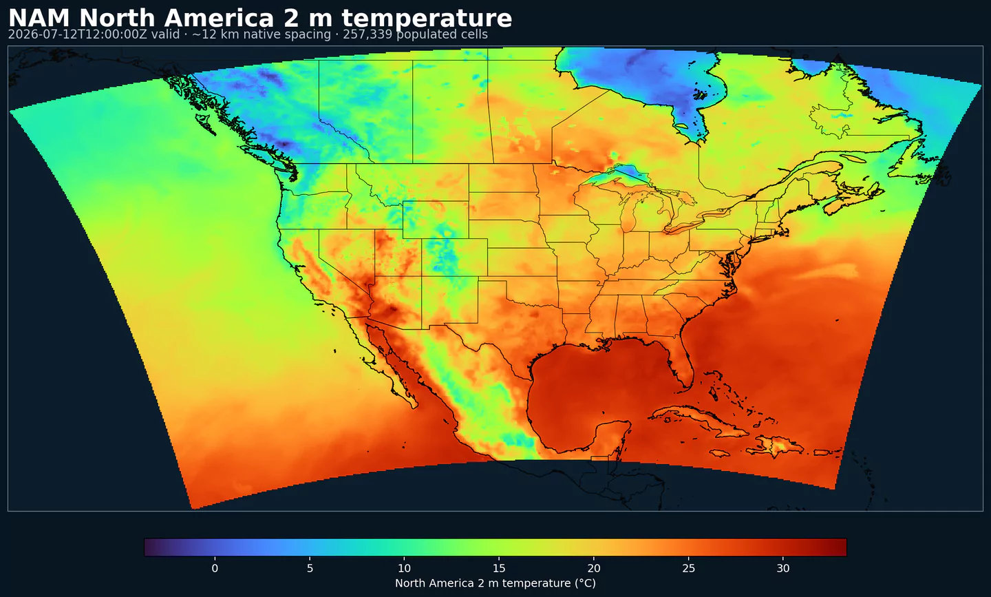
NAM CONUS Upper Air es la configuración del North American Mesoscale (NAM) orientada a campos en altura para Estados Unidos continental.
En GribStream, el dataset namawphys corresponde al producto público awphys en la grilla Lambert CONUS de 12 km. Es útil cuando necesitas más estructura regional que un modelo global, pero no necesitas toda la variabilidad de escala convectiva de HRRR.
La fuente incluye niveles de presión, superficie, capa límite, suelo y diagnósticos tipo radar en cuatro ciclos diarios. Ese equilibrio la hace práctica para planificación regional de corto plazo donde el horizonte de 84 h importa.
Para una salida más orientada a superficie, suelo, radiación y diagnósticos de columna, usa NAM CONUS Surface Diagnostics. Para detalle de 3 km dentro de la familia NAM, usa NAM CONUS Nest.
nam.tHHz.awphysFF.tm00.grib2 sobre la grilla Lambert CONUS 614x428.Haz clic en un parámetro para ver sus variantes en una tabla compacta con selectores JSON listos para copiar. Los códigos, niveles y valores de selector se mantienen exactamente como los expone la API.
Best (4-layer) lifted index uses parcels from the lowest four model layers to assess stability at 500 hPa. More negative values indicate greater instability.
| Level | Info | Horizon | Introduced | Selector |
|---|---|---|---|---|
180-0 mb above ground |
0h-84h | 2021-09-16 |
{"name":"4LFTX","level":"180-0 mb above ground","info":""}
|
Absolute vorticity combines relative vorticity and planetary vorticity from Earth's rotation. It highlights rotation and dynamical forcing in the flow.
| Level | Info | Horizon | Introduced | Selector |
|---|---|---|---|---|
1000 mb |
0h-84h | 2021-09-16 |
{"name":"ABSV","level":"1000 mb","info":""}
|
|
250 mb |
0h-84h | 2021-09-16 |
{"name":"ABSV","level":"250 mb","info":""}
|
|
500 mb |
0h-84h | 2021-09-16 |
{"name":"ABSV","level":"500 mb","info":""}
|
|
700 mb |
0h-84h | 2021-09-16 |
{"name":"ABSV","level":"700 mb","info":""}
|
|
850 mb |
0h-84h | 2021-09-16 |
{"name":"ABSV","level":"850 mb","info":""}
|
Convective precipitation accumulation represents precipitation produced by the convection scheme during the output period. It isolates convective rainfall from larger-scale precipitation.
| Level | Info | Horizon | Introduced | Selector |
|---|---|---|---|---|
surface |
0h-84h | 2021-09-16 |
{"name":"ACPCP","level":"surface","info":""}
|
Surface albedo is the fraction of incoming shortwave radiation reflected by the surface. Higher albedo means less solar energy absorbed and a cooler surface.
| Level | Info | Horizon | Introduced | Selector |
|---|---|---|---|---|
surface |
0h-84h | 2021-09-16 |
{"name":"ALBDO","level":"surface","info":""}
|
Accumulated precipitation represents the total water-equivalent amount of rain and snow during the output period. It is a primary field for hydrologic impacts and event totals.
| Level | Info | Horizon | Introduced | Selector |
|---|---|---|---|---|
surface |
0h-84h | 2021-09-16 |
{"name":"APCP","level":"surface","info":""}
|
Blackadar's mixing length scale is the turbulence length scale used by boundary-layer physics to limit the size of turbulent eddies. It directly affects the exchange coefficients that control momentum, heat, and moisture mixing near the surface and through the planetary boundary layer.
| Level | Info | Horizon | Introduced | Selector |
|---|---|---|---|---|
1 hybrid level |
0h-84h | 2021-09-16 |
{"name":"BMIXL","level":"1 hybrid level","info":""}
|
Convective Available Potential Energy (CAPE) quantifies buoyant energy available to rising air parcels. Larger values generally imply stronger potential updrafts and greater convective intensity.
| Level | Info | Horizon | Introduced | Selector |
|---|---|---|---|---|
180-0 mb above ground |
0h-84h | 2021-09-16 |
{"name":"CAPE","level":"180-0 mb above ground","info":""}
|
|
surface |
0h-84h | 2021-09-16 |
{"name":"CAPE","level":"surface","info":""}
|
Drag coefficient represents the aerodynamic resistance between the surface and the atmosphere. It controls surface stress and is used in momentum and heat flux calculations.
| Level | Info | Horizon | Introduced | Selector |
|---|---|---|---|---|
surface |
0h-84h | 2021-09-16 |
{"name":"CD","level":"surface","info":""}
|
Categorical indicator of freezing rain occurrence at the surface during the output period.
| Level | Info | Horizon | Introduced | Selector |
|---|---|---|---|---|
surface |
0h-84h | 2021-09-16 |
{"name":"CFRZR","level":"surface","info":""}
|
Categorical indicator of ice pellet (sleet) occurrence at the surface during the output period.
| Level | Info | Horizon | Introduced | Selector |
|---|---|---|---|---|
surface |
0h-84h | 2021-09-16 |
{"name":"CICEP","level":"surface","info":""}
|
Convective Inhibition (CIN) measures the energy barrier that must be overcome to initiate convection. More negative values indicate a stronger cap that can suppress storms.
| Level | Info | Horizon | Introduced | Selector |
|---|---|---|---|---|
180-0 mb above ground |
0h-84h | 2021-09-16 |
{"name":"CIN","level":"180-0 mb above ground","info":""}
|
|
surface |
0h-84h | 2021-09-16 |
{"name":"CIN","level":"surface","info":""}
|
Plant canopy surface water is liquid water intercepted by vegetation. It represents interception storage and evaporation potential.
| Level | Info | Horizon | Introduced | Selector |
|---|---|---|---|---|
surface |
0h-84h | 2021-09-16 |
{"name":"CNWAT","level":"surface","info":""}
|
Categorical indicator of rain occurrence at the surface during the output period. Useful as a yes/no mask for rain.
| Level | Info | Horizon | Introduced | Selector |
|---|---|---|---|---|
surface |
0h-84h | 2021-09-16 |
{"name":"CRAIN","level":"surface","info":""}
|
Categorical indicator of snow occurrence at the surface during the output period.
| Level | Info | Horizon | Introduced | Selector |
|---|---|---|---|---|
surface |
0h-84h | 2021-09-16 |
{"name":"CSNOW","level":"surface","info":""}
|
Downward longwave (thermal) flux represents incoming energy at the surface. It is a key driver of surface heating and cooling.
| Level | Info | Horizon | Introduced | Selector |
|---|---|---|---|---|
surface |
0h-84h | 2021-09-16 |
{"name":"DLWRF","level":"surface","info":""}
|
Dew point temperature is the temperature at which the air becomes saturated. It is a direct measure of moisture content.
| Level | Info | Horizon | Introduced | Selector |
|---|---|---|---|---|
2 m above ground |
0h-84h | 2021-09-16 |
{"name":"DPT","level":"2 m above ground","info":""}
|
Downward radiative flux represents incoming energy at the surface. It is a key driver of surface heating and cooling.
| Level | Info | Horizon | Introduced | Selector |
|---|---|---|---|---|
surface |
0h-84h | 2021-09-16 |
{"name":"DSWRF","level":"surface","info":""}
|
Geometric vertical velocity (dz/dt) is the vertical speed of air in height coordinates. Positive values indicate rising motion and negative values sinking motion.
| Level | Info | Horizon | Introduced | Selector |
|---|---|---|---|---|
10 mb |
0h-84h | 2021-09-16 |
{"name":"DZDT","level":"10 mb","info":""}
|
|
100 mb |
0h-84h | 2021-09-16 |
{"name":"DZDT","level":"100 mb","info":""}
|
|
1000 mb |
0h-84h | 2021-09-16 |
{"name":"DZDT","level":"1000 mb","info":""}
|
|
125 mb |
0h-84h | 2021-09-16 |
{"name":"DZDT","level":"125 mb","info":""}
|
|
150 mb |
0h-84h | 2021-09-16 |
{"name":"DZDT","level":"150 mb","info":""}
|
|
175 mb |
0h-84h | 2021-09-16 |
{"name":"DZDT","level":"175 mb","info":""}
|
|
20 mb |
0h-84h | 2021-09-16 |
{"name":"DZDT","level":"20 mb","info":""}
|
|
200 mb |
0h-84h | 2021-09-16 |
{"name":"DZDT","level":"200 mb","info":""}
|
|
225 mb |
0h-84h | 2021-09-16 |
{"name":"DZDT","level":"225 mb","info":""}
|
|
250 mb |
0h-84h | 2021-09-16 |
{"name":"DZDT","level":"250 mb","info":""}
|
|
275 mb |
0h-84h | 2021-09-16 |
{"name":"DZDT","level":"275 mb","info":""}
|
|
300 mb |
0h-84h | 2021-09-16 |
{"name":"DZDT","level":"300 mb","info":""}
|
|
325 mb |
0h-84h | 2021-09-16 |
{"name":"DZDT","level":"325 mb","info":""}
|
|
350 mb |
0h-84h | 2021-09-16 |
{"name":"DZDT","level":"350 mb","info":""}
|
|
375 mb |
0h-84h | 2021-09-16 |
{"name":"DZDT","level":"375 mb","info":""}
|
|
400 mb |
0h-84h | 2021-09-16 |
{"name":"DZDT","level":"400 mb","info":""}
|
|
425 mb |
0h-84h | 2021-09-16 |
{"name":"DZDT","level":"425 mb","info":""}
|
|
450 mb |
0h-84h | 2021-09-16 |
{"name":"DZDT","level":"450 mb","info":""}
|
|
475 mb |
0h-84h | 2021-09-16 |
{"name":"DZDT","level":"475 mb","info":""}
|
|
5 mb |
0h-84h | 2021-09-16 |
{"name":"DZDT","level":"5 mb","info":""}
|
|
50 mb |
0h-84h | 2021-09-16 |
{"name":"DZDT","level":"50 mb","info":""}
|
|
500 mb |
0h-84h | 2021-09-16 |
{"name":"DZDT","level":"500 mb","info":""}
|
|
525 mb |
0h-84h | 2021-09-16 |
{"name":"DZDT","level":"525 mb","info":""}
|
|
550 mb |
0h-84h | 2021-09-16 |
{"name":"DZDT","level":"550 mb","info":""}
|
|
575 mb |
0h-84h | 2021-09-16 |
{"name":"DZDT","level":"575 mb","info":""}
|
|
600 mb |
0h-84h | 2021-09-16 |
{"name":"DZDT","level":"600 mb","info":""}
|
|
625 mb |
0h-84h | 2021-09-16 |
{"name":"DZDT","level":"625 mb","info":""}
|
|
650 mb |
0h-84h | 2021-09-16 |
{"name":"DZDT","level":"650 mb","info":""}
|
|
675 mb |
0h-84h | 2021-09-16 |
{"name":"DZDT","level":"675 mb","info":""}
|
|
700 mb |
0h-84h | 2021-09-16 |
{"name":"DZDT","level":"700 mb","info":""}
|
|
725 mb |
0h-84h | 2021-09-16 |
{"name":"DZDT","level":"725 mb","info":""}
|
|
75 mb |
0h-84h | 2021-09-16 |
{"name":"DZDT","level":"75 mb","info":""}
|
|
750 mb |
0h-84h | 2021-09-16 |
{"name":"DZDT","level":"750 mb","info":""}
|
|
775 mb |
0h-84h | 2021-09-16 |
{"name":"DZDT","level":"775 mb","info":""}
|
|
800 mb |
0h-84h | 2021-09-16 |
{"name":"DZDT","level":"800 mb","info":""}
|
|
825 mb |
0h-84h | 2021-09-16 |
{"name":"DZDT","level":"825 mb","info":""}
|
|
850 mb |
0h-84h | 2021-09-16 |
{"name":"DZDT","level":"850 mb","info":""}
|
|
875 mb |
0h-84h | 2021-09-16 |
{"name":"DZDT","level":"875 mb","info":""}
|
|
900 mb |
0h-84h | 2021-09-16 |
{"name":"DZDT","level":"900 mb","info":""}
|
|
925 mb |
0h-84h | 2021-09-16 |
{"name":"DZDT","level":"925 mb","info":""}
|
|
950 mb |
0h-84h | 2021-09-16 |
{"name":"DZDT","level":"950 mb","info":""}
|
|
975 mb |
0h-84h | 2021-09-16 |
{"name":"DZDT","level":"975 mb","info":""}
|
Friction velocity (u*) is a measure of near‑surface shear stress. It is commonly used in turbulence, dust, and air‑sea exchange calculations.
| Level | Info | Horizon | Introduced | Selector |
|---|---|---|---|---|
surface |
0h-84h | 2021-09-16 |
{"name":"FRICV","level":"surface","info":""}
|
Wind gust is the peak short-duration wind speed. It captures brief, hazardous bursts that can exceed sustained winds.
| Level | Info | Horizon | Introduced | Selector |
|---|---|---|---|---|
surface |
0h-84h | 2021-09-16 |
{"name":"GUST","level":"surface","info":""}
|
Geopotential height is the altitude of a pressure surface in the atmosphere. It is the primary field for identifying ridges, troughs, and large‑scale flow patterns.
| Level | Info | Horizon | Introduced | Selector |
|---|---|---|---|---|
0C isotherm |
0h-84h | 2021-09-16 |
{"name":"HGT","level":"0C isotherm","info":""}
|
|
100 mb |
0h-84h | 2021-09-16 |
{"name":"HGT","level":"100 mb","info":""}
|
|
1000 mb |
0h-84h | 2021-09-16 |
{"name":"HGT","level":"1000 mb","info":""}
|
|
125 mb |
0h-84h | 2021-09-16 |
{"name":"HGT","level":"125 mb","info":""}
|
|
150 mb |
0h-84h | 2021-09-16 |
{"name":"HGT","level":"150 mb","info":""}
|
|
175 mb |
0h-84h | 2021-09-16 |
{"name":"HGT","level":"175 mb","info":""}
|
|
200 mb |
0h-84h | 2021-09-16 |
{"name":"HGT","level":"200 mb","info":""}
|
|
225 mb |
0h-84h | 2021-09-16 |
{"name":"HGT","level":"225 mb","info":""}
|
|
250 mb |
0h-84h | 2021-09-16 |
{"name":"HGT","level":"250 mb","info":""}
|
|
275 mb |
0h-84h | 2021-09-16 |
{"name":"HGT","level":"275 mb","info":""}
|
|
300 mb |
0h-84h | 2021-09-16 |
{"name":"HGT","level":"300 mb","info":""}
|
|
325 mb |
0h-84h | 2021-09-16 |
{"name":"HGT","level":"325 mb","info":""}
|
|
350 mb |
0h-84h | 2021-09-16 |
{"name":"HGT","level":"350 mb","info":""}
|
|
375 mb |
0h-84h | 2021-09-16 |
{"name":"HGT","level":"375 mb","info":""}
|
|
400 mb |
0h-84h | 2021-09-16 |
{"name":"HGT","level":"400 mb","info":""}
|
|
425 mb |
0h-84h | 2021-09-16 |
{"name":"HGT","level":"425 mb","info":""}
|
|
450 mb |
0h-84h | 2021-09-16 |
{"name":"HGT","level":"450 mb","info":""}
|
|
475 mb |
0h-84h | 2021-09-16 |
{"name":"HGT","level":"475 mb","info":""}
|
|
50 mb |
0h-84h | 2021-09-16 |
{"name":"HGT","level":"50 mb","info":""}
|
|
500 mb |
0h-84h | 2021-09-16 |
{"name":"HGT","level":"500 mb","info":""}
|
|
525 mb |
0h-84h | 2021-09-16 |
{"name":"HGT","level":"525 mb","info":""}
|
|
550 mb |
0h-84h | 2021-09-16 |
{"name":"HGT","level":"550 mb","info":""}
|
|
575 mb |
0h-84h | 2021-09-16 |
{"name":"HGT","level":"575 mb","info":""}
|
|
600 mb |
0h-84h | 2021-09-16 |
{"name":"HGT","level":"600 mb","info":""}
|
|
625 mb |
0h-84h | 2021-09-16 |
{"name":"HGT","level":"625 mb","info":""}
|
|
650 mb |
0h-84h | 2021-09-16 |
{"name":"HGT","level":"650 mb","info":""}
|
|
675 mb |
0h-84h | 2021-09-16 |
{"name":"HGT","level":"675 mb","info":""}
|
|
700 mb |
0h-84h | 2021-09-16 |
{"name":"HGT","level":"700 mb","info":""}
|
|
725 mb |
0h-84h | 2021-09-16 |
{"name":"HGT","level":"725 mb","info":""}
|
|
75 mb |
0h-84h | 2021-09-16 |
{"name":"HGT","level":"75 mb","info":""}
|
|
750 mb |
0h-84h | 2021-09-16 |
{"name":"HGT","level":"750 mb","info":""}
|
|
775 mb |
0h-84h | 2021-09-16 |
{"name":"HGT","level":"775 mb","info":""}
|
|
800 mb |
0h-84h | 2021-09-16 |
{"name":"HGT","level":"800 mb","info":""}
|
|
825 mb |
0h-84h | 2021-09-16 |
{"name":"HGT","level":"825 mb","info":""}
|
|
850 mb |
0h-84h | 2021-09-16 |
{"name":"HGT","level":"850 mb","info":""}
|
|
875 mb |
0h-84h | 2021-09-16 |
{"name":"HGT","level":"875 mb","info":""}
|
|
900 mb |
0h-84h | 2021-09-16 |
{"name":"HGT","level":"900 mb","info":""}
|
|
925 mb |
0h-84h | 2021-09-16 |
{"name":"HGT","level":"925 mb","info":""}
|
|
950 mb |
0h-84h | 2021-09-16 |
{"name":"HGT","level":"950 mb","info":""}
|
|
975 mb |
0h-84h | 2021-09-16 |
{"name":"HGT","level":"975 mb","info":""}
|
|
cloud base |
0h-84h | 2021-09-16 |
{"name":"HGT","level":"cloud base","info":""}
|
|
lowest level of the wet bulb zero |
0h-84h | 2021-09-16 |
{"name":"HGT","level":"lowest level of the wet bulb zero","info":""}
|
|
planetary boundary layer |
0h-84h | 2021-09-16 |
{"name":"HGT","level":"planetary boundary layer","info":""}
|
|
surface |
0h-84h | 2021-09-16 |
{"name":"HGT","level":"surface","info":""}
|
Haines Index combines atmospheric stability and dryness to estimate the potential for large fire growth. Higher values indicate a more favorable environment for extreme fire behavior.
| Level | Info | Horizon | Introduced | Selector |
|---|---|---|---|---|
surface |
0h-84h | 2021-09-16 |
{"name":"HINDEX","level":"surface","info":""}
|
Storm-relative helicity measures the potential for streamwise vorticity to be ingested by a storm updraft. Higher values suggest a greater likelihood of rotating updrafts.
| Level | Info | Horizon | Introduced | Selector |
|---|---|---|---|---|
3000-0 m above ground |
0h-84h | 2021-09-16 |
{"name":"HLCY","level":"3000-0 m above ground","info":""}
|
Boundary layer height marks the depth of the turbulent surface-influenced layer. It affects mixing, dispersion, and surface fluxes.
| Level | Info | Horizon | Introduced | Selector |
|---|---|---|---|---|
surface |
0h-84h | 2021-09-16 |
{"name":"HPBL","level":"surface","info":""}
|
Ice cover is the proportion of the grid cell covered by ice. It is used as a surface-state mask for sea ice and related cryosphere diagnostics.
| Level | Info | Horizon | Introduced | Selector |
|---|---|---|---|---|
surface |
0h-84h | 2021-09-16 |
{"name":"ICEC","level":"surface","info":""}
|
Land cover is a land/sea mask where 0 indicates sea and 1 indicates land. It is used to separate land and ocean surface processes.
| Level | Info | Horizon | Introduced | Selector |
|---|---|---|---|---|
surface |
0h-84h | 2021-09-16 |
{"name":"LAND","level":"surface","info":""}
|
Lifted Index compares a lifted parcel's temperature to the environment at 500 hPa. More negative values indicate greater instability and thunderstorm potential.
| Level | Info | Horizon | Introduced | Selector |
|---|---|---|---|---|
500-1000 mb |
0h-84h | 2021-09-16 |
{"name":"LFTX","level":"500-1000 mb","info":""}
|
Latent heat net flux represents energy exchange due to evaporation/condensation at the surface. It links moisture and energy budgets.
| Level | Info | Horizon | Introduced | Selector |
|---|---|---|---|---|
surface |
0h-84h | 2021-09-16 |
{"name":"LHTFL","level":"surface","info":""}
|
Lightning is a dimensionless model diagnostic in these NOAA mesoscale inventories. Higher values indicate greater modeled lightning or convective electrical activity.
| Level | Info | Horizon | Introduced | Selector |
|---|---|---|---|---|
surface |
0h-84h | 2021-09-16 |
{"name":"LTNG","level":"surface","info":""}
|
Maximum relative humidity is the highest RH reached during the period. It can indicate peak cloud or fog potential.
| Level | Info | Horizon | Introduced | Selector |
|---|---|---|---|---|
2 m above ground |
1h-84h | 2021-09-16 |
{"name":"MAXRH","level":"2 m above ground","info":""}
|
Maximum u‑component of wind is the strongest east‑west flow during the period. It helps identify peak wind directions.
| Level | Info | Horizon | Introduced | Selector |
|---|---|---|---|---|
10 m above ground |
1h-84h | 2021-09-16 |
{"name":"MAXUW","level":"10 m above ground","info":""}
|
Maximum v‑component of wind is the strongest north‑south flow during the period.
| Level | Info | Horizon | Introduced | Selector |
|---|---|---|---|---|
10 m above ground |
1h-84h | 2021-09-16 |
{"name":"MAXVW","level":"10 m above ground","info":""}
|
Minimum relative humidity is the lowest RH reached during the period. It is used in fire‑weather and drying assessments.
| Level | Info | Horizon | Introduced | Selector |
|---|---|---|---|---|
2 m above ground |
1h-84h | 2021-09-16 |
{"name":"MINRH","level":"2 m above ground","info":""}
|
Mean sea level pressure (ETA reduction) is MSLP computed using the ETA model reduction method. It is used for synoptic analysis.
| Level | Info | Horizon | Introduced | Selector |
|---|---|---|---|---|
mean sea level |
0h-84h | 2021-09-16 |
{"name":"MSLET","level":"mean sea level","info":""}
|
Moisture availability represents how much moisture is available at the surface for evaporation. It is used in land-surface and fire-weather diagnostics.
| Level | Info | Horizon | Introduced | Selector |
|---|---|---|---|---|
0-1 m below ground |
0h-84h | 2021-09-16 |
{"name":"MSTAV","level":"0-1 m below ground","info":""}
|
Parcel lifted index compares a lifted parcel temperature to the environment at 500 hPa. More negative values indicate greater instability and thunderstorm potential.
| Level | Info | Horizon | Introduced | Selector |
|---|---|---|---|---|
30-0 mb above ground |
0h-84h | 2021-09-16 |
{"name":"PLI","level":"30-0 mb above ground","info":""}
|
Soil porosity is the fraction of soil volume that is pore space. It governs storage and drainage capacity.
| Level | Info | Horizon | Introduced | Selector |
|---|---|---|---|---|
surface |
0h-84h | 2021-09-16 |
{"name":"POROS","level":"surface","info":""}
|
Pressure is the atmospheric pressure at the specified level. It is a fundamental mass-field variable for dynamics and thermodynamics.
| Level | Info | Horizon | Introduced | Selector |
|---|---|---|---|---|
80 m above ground |
0h-84h | 2021-09-16 |
{"name":"PRES","level":"80 m above ground","info":""}
|
|
max wind |
0h-84h | 2021-09-16 |
{"name":"PRES","level":"max wind","info":""}
|
|
surface |
0h-84h | 2021-09-16 |
{"name":"PRES","level":"surface","info":""}
|
|
tropopause |
0h-84h | 2021-09-16 |
{"name":"PRES","level":"tropopause","info":""}
|
Pressure reduced to mean sea level is MSLP computed from surface pressure and temperature. It is used to locate highs and lows.
| Level | Info | Horizon | Introduced | Selector |
|---|---|---|---|---|
mean sea level |
0h-84h | 2021-09-16 |
{"name":"PRMSL","level":"mean sea level","info":""}
|
Precipitable water is the total column water vapor from the surface to the top of the atmosphere. It is a key moisture indicator.
| Level | Info | Horizon | Introduced | Selector |
|---|---|---|---|---|
entire atmosphere (considered as a single layer) |
0h-84h | 2021-09-16 |
{"name":"PWAT","level":"entire atmosphere (considered as a single layer)","info":""}
|
Composite reflectivity is the maximum reflectivity in the column. It is a standard radar‑style field for identifying convective cores and precipitation intensity.
| Level | Info | Horizon | Introduced | Selector |
|---|---|---|---|---|
entire atmosphere (considered as a single layer) |
0h-84h | 2021-09-16 |
{"name":"REFC","level":"entire atmosphere (considered as a single layer)","info":""}
|
Reflectivity is a radar‑style measure of hydrometeor concentration at a given level. Higher values generally correspond to heavier precipitation.
| Level | Info | Horizon | Introduced | Selector |
|---|---|---|---|---|
1 hybrid level |
0h-84h | 2021-09-16 |
{"name":"REFD","level":"1 hybrid level","info":""}
|
|
1000 m above ground |
0h-84h | 2021-09-16 |
{"name":"REFD","level":"1000 m above ground","info":""}
|
|
4000 m above ground |
0h-84h | 2021-09-16 |
{"name":"REFD","level":"4000 m above ground","info":""}
|
Echo top height is the altitude of the highest reflectivity in the column. It is a proxy for storm depth and convective vigor.
| Level | Info | Horizon | Introduced | Selector |
|---|---|---|---|---|
entire atmosphere (considered as a single layer) |
0h-84h | 2021-09-16 |
{"name":"RETOP","level":"entire atmosphere (considered as a single layer)","info":""}
|
Relative humidity describes how close the air is to saturation at the specified level. High values favor cloud formation.
| Level | Info | Horizon | Introduced | Selector |
|---|---|---|---|---|
0.33-1 sigma layer |
0h-84h | 2021-09-16 |
{"name":"RH","level":"0.33-1 sigma layer","info":""}
|
|
0C isotherm |
0h-84h | 2021-09-16 |
{"name":"RH","level":"0C isotherm","info":""}
|
|
100 mb |
0h-84h | 2021-09-16 |
{"name":"RH","level":"100 mb","info":""}
|
|
1000 mb |
0h-84h | 2021-09-16 |
{"name":"RH","level":"1000 mb","info":""}
|
|
120-90 mb above ground |
0h-84h | 2021-09-16 |
{"name":"RH","level":"120-90 mb above ground","info":""}
|
|
125 mb |
0h-84h | 2021-09-16 |
{"name":"RH","level":"125 mb","info":""}
|
|
150 mb |
0h-84h | 2021-09-16 |
{"name":"RH","level":"150 mb","info":""}
|
|
150-120 mb above ground |
0h-84h | 2021-09-16 |
{"name":"RH","level":"150-120 mb above ground","info":""}
|
|
175 mb |
0h-84h | 2021-09-16 |
{"name":"RH","level":"175 mb","info":""}
|
|
180-150 mb above ground |
0h-84h | 2021-09-16 |
{"name":"RH","level":"180-150 mb above ground","info":""}
|
|
2 m above ground |
0h-84h | 2021-09-16 |
{"name":"RH","level":"2 m above ground","info":""}
|
|
200 mb |
0h-84h | 2021-09-16 |
{"name":"RH","level":"200 mb","info":""}
|
|
225 mb |
0h-84h | 2021-09-16 |
{"name":"RH","level":"225 mb","info":""}
|
|
250 mb |
0h-84h | 2021-09-16 |
{"name":"RH","level":"250 mb","info":""}
|
|
275 mb |
0h-84h | 2021-09-16 |
{"name":"RH","level":"275 mb","info":""}
|
|
30-0 mb above ground |
0h-84h | 2021-09-16 |
{"name":"RH","level":"30-0 mb above ground","info":""}
|
|
300 mb |
0h-84h | 2021-09-16 |
{"name":"RH","level":"300 mb","info":""}
|
|
325 mb |
0h-84h | 2021-09-16 |
{"name":"RH","level":"325 mb","info":""}
|
|
350 mb |
0h-84h | 2021-09-16 |
{"name":"RH","level":"350 mb","info":""}
|
|
375 mb |
0h-84h | 2021-09-16 |
{"name":"RH","level":"375 mb","info":""}
|
|
400 mb |
0h-84h | 2021-09-16 |
{"name":"RH","level":"400 mb","info":""}
|
|
425 mb |
0h-84h | 2021-09-16 |
{"name":"RH","level":"425 mb","info":""}
|
|
450 mb |
0h-84h | 2021-09-16 |
{"name":"RH","level":"450 mb","info":""}
|
|
475 mb |
0h-84h | 2021-09-16 |
{"name":"RH","level":"475 mb","info":""}
|
|
50 mb |
0h-84h | 2021-09-16 |
{"name":"RH","level":"50 mb","info":""}
|
|
500 mb |
0h-84h | 2021-09-16 |
{"name":"RH","level":"500 mb","info":""}
|
|
525 mb |
0h-84h | 2021-09-16 |
{"name":"RH","level":"525 mb","info":""}
|
|
550 mb |
0h-84h | 2021-09-16 |
{"name":"RH","level":"550 mb","info":""}
|
|
575 mb |
0h-84h | 2021-09-16 |
{"name":"RH","level":"575 mb","info":""}
|
|
60-30 mb above ground |
0h-84h | 2021-09-16 |
{"name":"RH","level":"60-30 mb above ground","info":""}
|
|
600 mb |
0h-84h | 2021-09-16 |
{"name":"RH","level":"600 mb","info":""}
|
|
625 mb |
0h-84h | 2021-09-16 |
{"name":"RH","level":"625 mb","info":""}
|
|
650 mb |
0h-84h | 2021-09-16 |
{"name":"RH","level":"650 mb","info":""}
|
|
675 mb |
0h-84h | 2021-09-16 |
{"name":"RH","level":"675 mb","info":""}
|
|
700 mb |
0h-84h | 2021-09-16 |
{"name":"RH","level":"700 mb","info":""}
|
|
725 mb |
0h-84h | 2021-09-16 |
{"name":"RH","level":"725 mb","info":""}
|
|
75 mb |
0h-84h | 2021-09-16 |
{"name":"RH","level":"75 mb","info":""}
|
|
750 mb |
0h-84h | 2021-09-16 |
{"name":"RH","level":"750 mb","info":""}
|
|
775 mb |
0h-84h | 2021-09-16 |
{"name":"RH","level":"775 mb","info":""}
|
|
800 mb |
0h-84h | 2021-09-16 |
{"name":"RH","level":"800 mb","info":""}
|
|
825 mb |
0h-84h | 2021-09-16 |
{"name":"RH","level":"825 mb","info":""}
|
|
850 mb |
0h-84h | 2021-09-16 |
{"name":"RH","level":"850 mb","info":""}
|
|
875 mb |
0h-84h | 2021-09-16 |
{"name":"RH","level":"875 mb","info":""}
|
|
90-60 mb above ground |
0h-84h | 2021-09-16 |
{"name":"RH","level":"90-60 mb above ground","info":""}
|
|
900 mb |
0h-84h | 2021-09-16 |
{"name":"RH","level":"900 mb","info":""}
|
|
925 mb |
0h-84h | 2021-09-16 |
{"name":"RH","level":"925 mb","info":""}
|
|
950 mb |
0h-84h | 2021-09-16 |
{"name":"RH","level":"950 mb","info":""}
|
|
975 mb |
0h-84h | 2021-09-16 |
{"name":"RH","level":"975 mb","info":""}
|
Number of soil layers is a static model metadata field describing the soil discretization.
| Level | Info | Horizon | Introduced | Selector |
|---|---|---|---|---|
surface |
0h-84h | 2021-09-16 |
{"name":"RLYRS","level":"surface","info":""}
|
Surface roughness length is the effective height of surface obstacles that control drag. It strongly influences near-surface wind, turbulence, and exchange fluxes.
| Level | Info | Horizon | Introduced | Selector |
|---|---|---|---|---|
surface |
0h-84h | 2021-09-16 |
{"name":"SFCR","level":"surface","info":""}
|
Sensible heat net flux is turbulent heat exchange driven by temperature differences. It affects near‑surface temperature and stability.
| Level | Info | Horizon | Introduced | Selector |
|---|---|---|---|---|
surface |
0h-84h | 2021-09-16 |
{"name":"SHTFL","level":"surface","info":""}
|
Direct evaporation cease (soil moisture) is the threshold below which bare-soil evaporation is shut off in the land-surface model.
| Level | Info | Horizon | Introduced | Selector |
|---|---|---|---|---|
surface |
0h-84h | 2021-09-16 |
{"name":"SMDRY","level":"surface","info":""}
|
Transpiration stress-onset (soil moisture) is the threshold at which plants begin to experience moisture stress in the land-surface model.
| Level | Info | Horizon | Introduced | Selector |
|---|---|---|---|---|
surface |
0h-84h | 2021-09-16 |
{"name":"SMREF","level":"surface","info":""}
|
Snow depth is the physical thickness of the snowpack. It is distinct from snow water equivalent, which measures water content.
| Level | Info | Horizon | Introduced | Selector |
|---|---|---|---|---|
surface |
0h-84h | 2021-09-16 |
{"name":"SNOD","level":"surface","info":""}
|
Snow cover is the fraction of the grid cell covered by snow. It helps interpret albedo, runoff timing, and surface energy balance.
| Level | Info | Horizon | Introduced | Selector |
|---|---|---|---|---|
surface |
0h-84h | 2021-09-16 |
{"name":"SNOWC","level":"surface","info":""}
|
Liquid volumetric soil moisture (non-frozen) is the liquid portion of soil water expressed as a proportion of soil volume, excluding soil ice.
| Level | Info | Horizon | Introduced | Selector |
|---|---|---|---|---|
0-0.1 m below ground |
0h-84h | 2021-09-16 |
{"name":"SOILL","level":"0-0.1 m below ground","info":""}
|
|
0.1-0.4 m below ground |
0h-84h | 2021-09-16 |
{"name":"SOILL","level":"0.1-0.4 m below ground","info":""}
|
|
0.4-1 m below ground |
0h-84h | 2021-09-16 |
{"name":"SOILL","level":"0.4-1 m below ground","info":""}
|
|
1-2 m below ground |
0h-84h | 2021-09-16 |
{"name":"SOILL","level":"1-2 m below ground","info":""}
|
Soil moisture content is the amount of water stored in the soil layer or column represented by the product.
| Level | Info | Horizon | Introduced | Selector |
|---|---|---|---|---|
0-2 m below ground |
0h-84h | 2021-09-16 |
{"name":"SOILM","level":"0-2 m below ground","info":""}
|
Volumetric soil moisture is the fraction of soil volume occupied by water. It is commonly used in hydrology and drought monitoring.
| Level | Info | Horizon | Introduced | Selector |
|---|---|---|---|---|
0-0.1 m below ground |
0h-84h | 2021-09-16 |
{"name":"SOILW","level":"0-0.1 m below ground","info":""}
|
|
0.1-0.4 m below ground |
0h-84h | 2021-09-16 |
{"name":"SOILW","level":"0.1-0.4 m below ground","info":""}
|
|
0.4-1 m below ground |
0h-84h | 2021-09-16 |
{"name":"SOILW","level":"0.4-1 m below ground","info":""}
|
|
1-2 m below ground |
0h-84h | 2021-09-16 |
{"name":"SOILW","level":"1-2 m below ground","info":""}
|
Soil type class used by the land-surface model. It controls infiltration, drainage, and heat/moisture storage, and strongly affects runoff and evapotranspiration.
| Level | Info | Horizon | Introduced | Selector |
|---|---|---|---|---|
surface |
0h-84h | 2021-09-16 |
{"name":"SOTYP","level":"surface","info":""}
|
Specific humidity is the mass of water vapor per mass of air at the specified level. It is central to moisture transport.
| Level | Info | Horizon | Introduced | Selector |
|---|---|---|---|---|
2 m above ground |
0h-84h | 2021-09-16 |
{"name":"SPFH","level":"2 m above ground","info":""}
|
|
80 m above ground |
0h-84h | 2021-09-16 |
{"name":"SPFH","level":"80 m above ground","info":""}
|
Total cloud cover is the fraction of the grid cell covered by clouds at any level. It influences radiation, temperature, and visibility.
| Level | Info | Horizon | Introduced | Selector |
|---|---|---|---|---|
entire atmosphere (considered as a single layer) |
0h-84h | 2021-09-16 |
{"name":"TCDC","level":"entire atmosphere (considered as a single layer)","info":""}
|
Turbulent kinetic energy represents the intensity of turbulent motions. Higher values indicate stronger mixing and potential turbulence.
| Level | Info | Horizon | Introduced | Selector |
|---|---|---|---|---|
100 mb |
0h-84h | 2021-09-16 |
{"name":"TKE","level":"100 mb","info":""}
|
|
1000 mb |
0h-84h | 2021-09-16 |
{"name":"TKE","level":"1000 mb","info":""}
|
|
125 mb |
0h-84h | 2021-09-16 |
{"name":"TKE","level":"125 mb","info":""}
|
|
150 mb |
0h-84h | 2021-09-16 |
{"name":"TKE","level":"150 mb","info":""}
|
|
175 mb |
0h-84h | 2021-09-16 |
{"name":"TKE","level":"175 mb","info":""}
|
|
200 mb |
0h-84h | 2021-09-16 |
{"name":"TKE","level":"200 mb","info":""}
|
|
225 mb |
0h-84h | 2021-09-16 |
{"name":"TKE","level":"225 mb","info":""}
|
|
250 mb |
0h-84h | 2021-09-16 |
{"name":"TKE","level":"250 mb","info":""}
|
|
275 mb |
0h-84h | 2021-09-16 |
{"name":"TKE","level":"275 mb","info":""}
|
|
300 mb |
0h-84h | 2021-09-16 |
{"name":"TKE","level":"300 mb","info":""}
|
|
325 mb |
0h-84h | 2021-09-16 |
{"name":"TKE","level":"325 mb","info":""}
|
|
350 mb |
0h-84h | 2021-09-16 |
{"name":"TKE","level":"350 mb","info":""}
|
|
375 mb |
0h-84h | 2021-09-16 |
{"name":"TKE","level":"375 mb","info":""}
|
|
400 mb |
0h-84h | 2021-09-16 |
{"name":"TKE","level":"400 mb","info":""}
|
|
425 mb |
0h-84h | 2021-09-16 |
{"name":"TKE","level":"425 mb","info":""}
|
|
450 mb |
0h-84h | 2021-09-16 |
{"name":"TKE","level":"450 mb","info":""}
|
|
475 mb |
0h-84h | 2021-09-16 |
{"name":"TKE","level":"475 mb","info":""}
|
|
50 mb |
0h-84h | 2021-09-16 |
{"name":"TKE","level":"50 mb","info":""}
|
|
500 mb |
0h-84h | 2021-09-16 |
{"name":"TKE","level":"500 mb","info":""}
|
|
525 mb |
0h-84h | 2021-09-16 |
{"name":"TKE","level":"525 mb","info":""}
|
|
550 mb |
0h-84h | 2021-09-16 |
{"name":"TKE","level":"550 mb","info":""}
|
|
575 mb |
0h-84h | 2021-09-16 |
{"name":"TKE","level":"575 mb","info":""}
|
|
600 mb |
0h-84h | 2021-09-16 |
{"name":"TKE","level":"600 mb","info":""}
|
|
625 mb |
0h-84h | 2021-09-16 |
{"name":"TKE","level":"625 mb","info":""}
|
|
650 mb |
0h-84h | 2021-09-16 |
{"name":"TKE","level":"650 mb","info":""}
|
|
675 mb |
0h-84h | 2021-09-16 |
{"name":"TKE","level":"675 mb","info":""}
|
|
700 mb |
0h-84h | 2021-09-16 |
{"name":"TKE","level":"700 mb","info":""}
|
|
725 mb |
0h-84h | 2021-09-16 |
{"name":"TKE","level":"725 mb","info":""}
|
|
75 mb |
0h-84h | 2021-09-16 |
{"name":"TKE","level":"75 mb","info":""}
|
|
750 mb |
0h-84h | 2021-09-16 |
{"name":"TKE","level":"750 mb","info":""}
|
|
775 mb |
0h-84h | 2021-09-16 |
{"name":"TKE","level":"775 mb","info":""}
|
|
800 mb |
0h-84h | 2021-09-16 |
{"name":"TKE","level":"800 mb","info":""}
|
|
825 mb |
0h-84h | 2021-09-16 |
{"name":"TKE","level":"825 mb","info":""}
|
|
850 mb |
0h-84h | 2021-09-16 |
{"name":"TKE","level":"850 mb","info":""}
|
|
875 mb |
0h-84h | 2021-09-16 |
{"name":"TKE","level":"875 mb","info":""}
|
|
900 mb |
0h-84h | 2021-09-16 |
{"name":"TKE","level":"900 mb","info":""}
|
|
925 mb |
0h-84h | 2021-09-16 |
{"name":"TKE","level":"925 mb","info":""}
|
|
950 mb |
0h-84h | 2021-09-16 |
{"name":"TKE","level":"950 mb","info":""}
|
|
975 mb |
0h-84h | 2021-09-16 |
{"name":"TKE","level":"975 mb","info":""}
|
Maximum temperature is the highest temperature reached during the output period. It is commonly used for heat stress and daily extremes.
| Level | Info | Horizon | Introduced | Selector |
|---|---|---|---|---|
2 m above ground |
1h-84h | 2021-09-16 |
{"name":"TMAX","level":"2 m above ground","info":""}
|
Minimum temperature is the lowest temperature reached during the output period. It is commonly used for frost and cold-stress assessment.
| Level | Info | Horizon | Introduced | Selector |
|---|---|---|---|---|
2 m above ground |
1h-84h | 2021-09-16 |
{"name":"TMIN","level":"2 m above ground","info":""}
|
Air temperature is the thermal state of the atmosphere at the specified level. It influences density, stability, and energy exchange.
| Level | Info | Horizon | Introduced | Selector |
|---|---|---|---|---|
100 mb |
0h-84h | 2021-09-16 |
{"name":"TMP","level":"100 mb","info":""}
|
|
1000 mb |
0h-84h | 2021-09-16 |
{"name":"TMP","level":"1000 mb","info":""}
|
|
120-90 mb above ground |
0h-84h | 2021-09-16 |
{"name":"TMP","level":"120-90 mb above ground","info":""}
|
|
125 mb |
0h-84h | 2021-09-16 |
{"name":"TMP","level":"125 mb","info":""}
|
|
150 mb |
0h-84h | 2021-09-16 |
{"name":"TMP","level":"150 mb","info":""}
|
|
150-120 mb above ground |
0h-84h | 2021-09-16 |
{"name":"TMP","level":"150-120 mb above ground","info":""}
|
|
175 mb |
0h-84h | 2021-09-16 |
{"name":"TMP","level":"175 mb","info":""}
|
|
180-150 mb above ground |
0h-84h | 2021-09-16 |
{"name":"TMP","level":"180-150 mb above ground","info":""}
|
|
2 m above ground |
0h-84h | 2021-09-16 |
{"name":"TMP","level":"2 m above ground","info":""}
|
|
200 mb |
0h-84h | 2021-09-16 |
{"name":"TMP","level":"200 mb","info":""}
|
|
225 mb |
0h-84h | 2021-09-16 |
{"name":"TMP","level":"225 mb","info":""}
|
|
250 mb |
0h-84h | 2021-09-16 |
{"name":"TMP","level":"250 mb","info":""}
|
|
275 mb |
0h-84h | 2021-09-16 |
{"name":"TMP","level":"275 mb","info":""}
|
|
30-0 mb above ground |
0h-84h | 2021-09-16 |
{"name":"TMP","level":"30-0 mb above ground","info":""}
|
|
300 mb |
0h-84h | 2021-09-16 |
{"name":"TMP","level":"300 mb","info":""}
|
|
325 mb |
0h-84h | 2021-09-16 |
{"name":"TMP","level":"325 mb","info":""}
|
|
350 mb |
0h-84h | 2021-09-16 |
{"name":"TMP","level":"350 mb","info":""}
|
|
375 mb |
0h-84h | 2021-09-16 |
{"name":"TMP","level":"375 mb","info":""}
|
|
400 mb |
0h-84h | 2021-09-16 |
{"name":"TMP","level":"400 mb","info":""}
|
|
425 mb |
0h-84h | 2021-09-16 |
{"name":"TMP","level":"425 mb","info":""}
|
|
450 mb |
0h-84h | 2021-09-16 |
{"name":"TMP","level":"450 mb","info":""}
|
|
475 mb |
0h-84h | 2021-09-16 |
{"name":"TMP","level":"475 mb","info":""}
|
|
50 mb |
0h-84h | 2021-09-16 |
{"name":"TMP","level":"50 mb","info":""}
|
|
500 mb |
0h-84h | 2021-09-16 |
{"name":"TMP","level":"500 mb","info":""}
|
|
525 mb |
0h-84h | 2021-09-16 |
{"name":"TMP","level":"525 mb","info":""}
|
|
550 mb |
0h-84h | 2021-09-16 |
{"name":"TMP","level":"550 mb","info":""}
|
|
575 mb |
0h-84h | 2021-09-16 |
{"name":"TMP","level":"575 mb","info":""}
|
|
60-30 mb above ground |
0h-84h | 2021-09-16 |
{"name":"TMP","level":"60-30 mb above ground","info":""}
|
|
600 mb |
0h-84h | 2021-09-16 |
{"name":"TMP","level":"600 mb","info":""}
|
|
625 mb |
0h-84h | 2021-09-16 |
{"name":"TMP","level":"625 mb","info":""}
|
|
650 mb |
0h-84h | 2021-09-16 |
{"name":"TMP","level":"650 mb","info":""}
|
|
675 mb |
0h-84h | 2021-09-16 |
{"name":"TMP","level":"675 mb","info":""}
|
|
700 mb |
0h-84h | 2021-09-16 |
{"name":"TMP","level":"700 mb","info":""}
|
|
725 mb |
0h-84h | 2021-09-16 |
{"name":"TMP","level":"725 mb","info":""}
|
|
75 mb |
0h-84h | 2021-09-16 |
{"name":"TMP","level":"75 mb","info":""}
|
|
750 mb |
0h-84h | 2021-09-16 |
{"name":"TMP","level":"750 mb","info":""}
|
|
775 mb |
0h-84h | 2021-09-16 |
{"name":"TMP","level":"775 mb","info":""}
|
|
80 m above ground |
0h-84h | 2021-09-16 |
{"name":"TMP","level":"80 m above ground","info":""}
|
|
800 mb |
0h-84h | 2021-09-16 |
{"name":"TMP","level":"800 mb","info":""}
|
|
825 mb |
0h-84h | 2021-09-16 |
{"name":"TMP","level":"825 mb","info":""}
|
|
850 mb |
0h-84h | 2021-09-16 |
{"name":"TMP","level":"850 mb","info":""}
|
|
875 mb |
0h-84h | 2021-09-16 |
{"name":"TMP","level":"875 mb","info":""}
|
|
90-60 mb above ground |
0h-84h | 2021-09-16 |
{"name":"TMP","level":"90-60 mb above ground","info":""}
|
|
900 mb |
0h-84h | 2021-09-16 |
{"name":"TMP","level":"900 mb","info":""}
|
|
925 mb |
0h-84h | 2021-09-16 |
{"name":"TMP","level":"925 mb","info":""}
|
|
950 mb |
0h-84h | 2021-09-16 |
{"name":"TMP","level":"950 mb","info":""}
|
|
975 mb |
0h-84h | 2021-09-16 |
{"name":"TMP","level":"975 mb","info":""}
|
|
surface |
0h-84h | 2021-09-16 |
{"name":"TMP","level":"surface","info":""}
|
|
tropopause |
0h-84h | 2021-09-16 |
{"name":"TMP","level":"tropopause","info":""}
|
Soil temperature describes the thermal state of the soil layer. It affects ground heat flux and freeze/thaw processes.
| Level | Info | Horizon | Introduced | Selector |
|---|---|---|---|---|
0-0.1 m below ground |
0h-84h | 2021-09-16 |
{"name":"TSOIL","level":"0-0.1 m below ground","info":""}
|
|
0.1-0.4 m below ground |
0h-84h | 2021-09-16 |
{"name":"TSOIL","level":"0.1-0.4 m below ground","info":""}
|
|
0.4-1 m below ground |
0h-84h | 2021-09-16 |
{"name":"TSOIL","level":"0.4-1 m below ground","info":""}
|
|
1-2 m below ground |
0h-84h | 2021-09-16 |
{"name":"TSOIL","level":"1-2 m below ground","info":""}
|
|
3 m underground |
0h-84h | 2021-09-16 |
{"name":"TSOIL","level":"3 m underground","info":""}
|
U‑component of wind is the east‑west component of the horizontal wind. Combine with v for speed and direction.
| Level | Info | Horizon | Introduced | Selector |
|---|---|---|---|---|
10 m above ground |
0h-84h | 2021-09-16 |
{"name":"UGRD","level":"10 m above ground","info":""}
|
|
100 mb |
0h-84h | 2021-09-16 |
{"name":"UGRD","level":"100 mb","info":""}
|
|
1000 mb |
0h-84h | 2021-09-16 |
{"name":"UGRD","level":"1000 mb","info":""}
|
|
120-90 mb above ground |
0h-84h | 2021-09-16 |
{"name":"UGRD","level":"120-90 mb above ground","info":""}
|
|
125 mb |
0h-84h | 2021-09-16 |
{"name":"UGRD","level":"125 mb","info":""}
|
|
150 mb |
0h-84h | 2021-09-16 |
{"name":"UGRD","level":"150 mb","info":""}
|
|
150-120 mb above ground |
0h-84h | 2021-09-16 |
{"name":"UGRD","level":"150-120 mb above ground","info":""}
|
|
175 mb |
0h-84h | 2021-09-16 |
{"name":"UGRD","level":"175 mb","info":""}
|
|
180-150 mb above ground |
0h-84h | 2021-09-16 |
{"name":"UGRD","level":"180-150 mb above ground","info":""}
|
|
200 mb |
0h-84h | 2021-09-16 |
{"name":"UGRD","level":"200 mb","info":""}
|
|
225 mb |
0h-84h | 2021-09-16 |
{"name":"UGRD","level":"225 mb","info":""}
|
|
250 mb |
0h-84h | 2021-09-16 |
{"name":"UGRD","level":"250 mb","info":""}
|
|
275 mb |
0h-84h | 2021-09-16 |
{"name":"UGRD","level":"275 mb","info":""}
|
|
30-0 mb above ground |
0h-84h | 2021-09-16 |
{"name":"UGRD","level":"30-0 mb above ground","info":""}
|
|
300 mb |
0h-84h | 2021-09-16 |
{"name":"UGRD","level":"300 mb","info":""}
|
|
325 mb |
0h-84h | 2021-09-16 |
{"name":"UGRD","level":"325 mb","info":""}
|
|
350 mb |
0h-84h | 2021-09-16 |
{"name":"UGRD","level":"350 mb","info":""}
|
|
375 mb |
0h-84h | 2021-09-16 |
{"name":"UGRD","level":"375 mb","info":""}
|
|
400 mb |
0h-84h | 2021-09-16 |
{"name":"UGRD","level":"400 mb","info":""}
|
|
425 mb |
0h-84h | 2021-09-16 |
{"name":"UGRD","level":"425 mb","info":""}
|
|
450 mb |
0h-84h | 2021-09-16 |
{"name":"UGRD","level":"450 mb","info":""}
|
|
475 mb |
0h-84h | 2021-09-16 |
{"name":"UGRD","level":"475 mb","info":""}
|
|
50 mb |
0h-84h | 2021-09-16 |
{"name":"UGRD","level":"50 mb","info":""}
|
|
500 mb |
0h-84h | 2021-09-16 |
{"name":"UGRD","level":"500 mb","info":""}
|
|
525 mb |
0h-84h | 2021-09-16 |
{"name":"UGRD","level":"525 mb","info":""}
|
|
550 mb |
0h-84h | 2021-09-16 |
{"name":"UGRD","level":"550 mb","info":""}
|
|
575 mb |
0h-84h | 2021-09-16 |
{"name":"UGRD","level":"575 mb","info":""}
|
|
60-30 mb above ground |
0h-84h | 2021-09-16 |
{"name":"UGRD","level":"60-30 mb above ground","info":""}
|
|
600 mb |
0h-84h | 2021-09-16 |
{"name":"UGRD","level":"600 mb","info":""}
|
|
625 mb |
0h-84h | 2021-09-16 |
{"name":"UGRD","level":"625 mb","info":""}
|
|
650 mb |
0h-84h | 2021-09-16 |
{"name":"UGRD","level":"650 mb","info":""}
|
|
675 mb |
0h-84h | 2021-09-16 |
{"name":"UGRD","level":"675 mb","info":""}
|
|
700 mb |
0h-84h | 2021-09-16 |
{"name":"UGRD","level":"700 mb","info":""}
|
|
725 mb |
0h-84h | 2021-09-16 |
{"name":"UGRD","level":"725 mb","info":""}
|
|
75 mb |
0h-84h | 2021-09-16 |
{"name":"UGRD","level":"75 mb","info":""}
|
|
750 mb |
0h-84h | 2021-09-16 |
{"name":"UGRD","level":"750 mb","info":""}
|
|
775 mb |
0h-84h | 2021-09-16 |
{"name":"UGRD","level":"775 mb","info":""}
|
|
80 m above ground |
0h-84h | 2021-09-16 |
{"name":"UGRD","level":"80 m above ground","info":""}
|
|
800 mb |
0h-84h | 2021-09-16 |
{"name":"UGRD","level":"800 mb","info":""}
|
|
825 mb |
0h-84h | 2021-09-16 |
{"name":"UGRD","level":"825 mb","info":""}
|
|
850 mb |
0h-84h | 2021-09-16 |
{"name":"UGRD","level":"850 mb","info":""}
|
|
875 mb |
0h-84h | 2021-09-16 |
{"name":"UGRD","level":"875 mb","info":""}
|
|
90-60 mb above ground |
0h-84h | 2021-09-16 |
{"name":"UGRD","level":"90-60 mb above ground","info":""}
|
|
900 mb |
0h-84h | 2021-09-16 |
{"name":"UGRD","level":"900 mb","info":""}
|
|
925 mb |
0h-84h | 2021-09-16 |
{"name":"UGRD","level":"925 mb","info":""}
|
|
950 mb |
0h-84h | 2021-09-16 |
{"name":"UGRD","level":"950 mb","info":""}
|
|
975 mb |
0h-84h | 2021-09-16 |
{"name":"UGRD","level":"975 mb","info":""}
|
|
max wind |
0h-84h | 2021-09-16 |
{"name":"UGRD","level":"max wind","info":""}
|
|
planetary boundary layer |
0h-84h | 2021-09-16 |
{"name":"UGRD","level":"planetary boundary layer","info":""}
|
|
tropopause |
0h-84h | 2021-09-16 |
{"name":"UGRD","level":"tropopause","info":""}
|
Upward longwave (thermal) flux represents outgoing energy at the surface. It is a key driver of surface heating and cooling.
| Level | Info | Horizon | Introduced | Selector |
|---|---|---|---|---|
surface |
0h-84h | 2021-09-16 |
{"name":"ULWRF","level":"surface","info":""}
|
Upward radiative flux represents outgoing energy at the surface. It is a key driver of surface heating and cooling.
| Level | Info | Horizon | Introduced | Selector |
|---|---|---|---|---|
surface |
0h-84h | 2021-09-16 |
{"name":"USWRF","level":"surface","info":""}
|
Vegetation fraction is the portion of the grid cell covered by vegetation. It affects albedo, roughness, and evapotranspiration.
| Level | Info | Horizon | Introduced | Selector |
|---|---|---|---|---|
surface |
0h-84h | 2021-09-16 |
{"name":"VEG","level":"surface","info":""}
|
V‑component of wind is the north‑south component of the horizontal wind. Combine with u for speed and direction.
| Level | Info | Horizon | Introduced | Selector |
|---|---|---|---|---|
10 m above ground |
0h-84h | 2021-09-16 |
{"name":"VGRD","level":"10 m above ground","info":""}
|
|
100 mb |
0h-84h | 2021-09-16 |
{"name":"VGRD","level":"100 mb","info":""}
|
|
1000 mb |
0h-84h | 2021-09-16 |
{"name":"VGRD","level":"1000 mb","info":""}
|
|
120-90 mb above ground |
0h-84h | 2021-09-16 |
{"name":"VGRD","level":"120-90 mb above ground","info":""}
|
|
125 mb |
0h-84h | 2021-09-16 |
{"name":"VGRD","level":"125 mb","info":""}
|
|
150 mb |
0h-84h | 2021-09-16 |
{"name":"VGRD","level":"150 mb","info":""}
|
|
150-120 mb above ground |
0h-84h | 2021-09-16 |
{"name":"VGRD","level":"150-120 mb above ground","info":""}
|
|
175 mb |
0h-84h | 2021-09-16 |
{"name":"VGRD","level":"175 mb","info":""}
|
|
180-150 mb above ground |
0h-84h | 2021-09-16 |
{"name":"VGRD","level":"180-150 mb above ground","info":""}
|
|
200 mb |
0h-84h | 2021-09-16 |
{"name":"VGRD","level":"200 mb","info":""}
|
|
225 mb |
0h-84h | 2021-09-16 |
{"name":"VGRD","level":"225 mb","info":""}
|
|
250 mb |
0h-84h | 2021-09-16 |
{"name":"VGRD","level":"250 mb","info":""}
|
|
275 mb |
0h-84h | 2021-09-16 |
{"name":"VGRD","level":"275 mb","info":""}
|
|
30-0 mb above ground |
0h-84h | 2021-09-16 |
{"name":"VGRD","level":"30-0 mb above ground","info":""}
|
|
300 mb |
0h-84h | 2021-09-16 |
{"name":"VGRD","level":"300 mb","info":""}
|
|
325 mb |
0h-84h | 2021-09-16 |
{"name":"VGRD","level":"325 mb","info":""}
|
|
350 mb |
0h-84h | 2021-09-16 |
{"name":"VGRD","level":"350 mb","info":""}
|
|
375 mb |
0h-84h | 2021-09-16 |
{"name":"VGRD","level":"375 mb","info":""}
|
|
400 mb |
0h-84h | 2021-09-16 |
{"name":"VGRD","level":"400 mb","info":""}
|
|
425 mb |
0h-84h | 2021-09-16 |
{"name":"VGRD","level":"425 mb","info":""}
|
|
450 mb |
0h-84h | 2021-09-16 |
{"name":"VGRD","level":"450 mb","info":""}
|
|
475 mb |
0h-84h | 2021-09-16 |
{"name":"VGRD","level":"475 mb","info":""}
|
|
50 mb |
0h-84h | 2021-09-16 |
{"name":"VGRD","level":"50 mb","info":""}
|
|
500 mb |
0h-84h | 2021-09-16 |
{"name":"VGRD","level":"500 mb","info":""}
|
|
525 mb |
0h-84h | 2021-09-16 |
{"name":"VGRD","level":"525 mb","info":""}
|
|
550 mb |
0h-84h | 2021-09-16 |
{"name":"VGRD","level":"550 mb","info":""}
|
|
575 mb |
0h-84h | 2021-09-16 |
{"name":"VGRD","level":"575 mb","info":""}
|
|
60-30 mb above ground |
0h-84h | 2021-09-16 |
{"name":"VGRD","level":"60-30 mb above ground","info":""}
|
|
600 mb |
0h-84h | 2021-09-16 |
{"name":"VGRD","level":"600 mb","info":""}
|
|
625 mb |
0h-84h | 2021-09-16 |
{"name":"VGRD","level":"625 mb","info":""}
|
|
650 mb |
0h-84h | 2021-09-16 |
{"name":"VGRD","level":"650 mb","info":""}
|
|
675 mb |
0h-84h | 2021-09-16 |
{"name":"VGRD","level":"675 mb","info":""}
|
|
700 mb |
0h-84h | 2021-09-16 |
{"name":"VGRD","level":"700 mb","info":""}
|
|
725 mb |
0h-84h | 2021-09-16 |
{"name":"VGRD","level":"725 mb","info":""}
|
|
75 mb |
0h-84h | 2021-09-16 |
{"name":"VGRD","level":"75 mb","info":""}
|
|
750 mb |
0h-84h | 2021-09-16 |
{"name":"VGRD","level":"750 mb","info":""}
|
|
775 mb |
0h-84h | 2021-09-16 |
{"name":"VGRD","level":"775 mb","info":""}
|
|
80 m above ground |
0h-84h | 2021-09-16 |
{"name":"VGRD","level":"80 m above ground","info":""}
|
|
800 mb |
0h-84h | 2021-09-16 |
{"name":"VGRD","level":"800 mb","info":""}
|
|
825 mb |
0h-84h | 2021-09-16 |
{"name":"VGRD","level":"825 mb","info":""}
|
|
850 mb |
0h-84h | 2021-09-16 |
{"name":"VGRD","level":"850 mb","info":""}
|
|
875 mb |
0h-84h | 2021-09-16 |
{"name":"VGRD","level":"875 mb","info":""}
|
|
90-60 mb above ground |
0h-84h | 2021-09-16 |
{"name":"VGRD","level":"90-60 mb above ground","info":""}
|
|
900 mb |
0h-84h | 2021-09-16 |
{"name":"VGRD","level":"900 mb","info":""}
|
|
925 mb |
0h-84h | 2021-09-16 |
{"name":"VGRD","level":"925 mb","info":""}
|
|
950 mb |
0h-84h | 2021-09-16 |
{"name":"VGRD","level":"950 mb","info":""}
|
|
975 mb |
0h-84h | 2021-09-16 |
{"name":"VGRD","level":"975 mb","info":""}
|
|
max wind |
0h-84h | 2021-09-16 |
{"name":"VGRD","level":"max wind","info":""}
|
|
planetary boundary layer |
0h-84h | 2021-09-16 |
{"name":"VGRD","level":"planetary boundary layer","info":""}
|
|
tropopause |
0h-84h | 2021-09-16 |
{"name":"VGRD","level":"tropopause","info":""}
|
Categorical land-use/vegetation class. It is used to set roughness, albedo, canopy properties, and other surface-exchange parameters.
| Level | Info | Horizon | Introduced | Selector |
|---|---|---|---|---|
surface |
0h-84h | 2021-09-16 |
{"name":"VGTYP","level":"surface","info":""}
|
Horizontal visibility at the surface. Lower values indicate reduced visibility due to fog, precipitation, or aerosols.
| Level | Info | Horizon | Introduced | Selector |
|---|---|---|---|---|
cloud top |
0h-84h | 2021-09-16 |
{"name":"VIS","level":"cloud top","info":""}
|
|
surface |
0h-84h | 2021-09-16 |
{"name":"VIS","level":"surface","info":""}
|
Ventilation rate combines mixing depth and transport wind to estimate the atmosphere's ability to disperse smoke and pollutants.
| Level | Info | Horizon | Introduced | Selector |
|---|---|---|---|---|
planetary boundary layer |
0h-84h | 2021-09-16 |
{"name":"VRATE","level":"planetary boundary layer","info":""}
|
Vertical u-component shear describes how the east-west wind component changes with height.
| Level | Info | Horizon | Introduced | Selector |
|---|---|---|---|---|
0-6000 m above ground |
0h-84h | 2021-09-16 |
{"name":"VUCSH","level":"0-6000 m above ground","info":""}
|
Vertical v-component shear describes how the north-south wind component changes with height.
| Level | Info | Horizon | Introduced | Selector |
|---|---|---|---|---|
0-6000 m above ground |
0h-84h | 2021-09-16 |
{"name":"VVCSH","level":"0-6000 m above ground","info":""}
|
Vertical velocity in pressure coordinates (omega). Negative values indicate upward motion (rising air); positive values indicate subsidence.
| Level | Info | Horizon | Introduced | Selector |
|---|---|---|---|---|
100 mb |
0h-84h | 2021-09-16 |
{"name":"VVEL","level":"100 mb","info":""}
|
|
1000 mb |
0h-84h | 2021-09-16 |
{"name":"VVEL","level":"1000 mb","info":""}
|
|
125 mb |
0h-84h | 2021-09-16 |
{"name":"VVEL","level":"125 mb","info":""}
|
|
150 mb |
0h-84h | 2021-09-16 |
{"name":"VVEL","level":"150 mb","info":""}
|
|
175 mb |
0h-84h | 2021-09-16 |
{"name":"VVEL","level":"175 mb","info":""}
|
|
200 mb |
0h-84h | 2021-09-16 |
{"name":"VVEL","level":"200 mb","info":""}
|
|
225 mb |
0h-84h | 2021-09-16 |
{"name":"VVEL","level":"225 mb","info":""}
|
|
250 mb |
0h-84h | 2021-09-16 |
{"name":"VVEL","level":"250 mb","info":""}
|
|
275 mb |
0h-84h | 2021-09-16 |
{"name":"VVEL","level":"275 mb","info":""}
|
|
300 mb |
0h-84h | 2021-09-16 |
{"name":"VVEL","level":"300 mb","info":""}
|
|
325 mb |
0h-84h | 2021-09-16 |
{"name":"VVEL","level":"325 mb","info":""}
|
|
350 mb |
0h-84h | 2021-09-16 |
{"name":"VVEL","level":"350 mb","info":""}
|
|
375 mb |
0h-84h | 2021-09-16 |
{"name":"VVEL","level":"375 mb","info":""}
|
|
400 mb |
0h-84h | 2021-09-16 |
{"name":"VVEL","level":"400 mb","info":""}
|
|
425 mb |
0h-84h | 2021-09-16 |
{"name":"VVEL","level":"425 mb","info":""}
|
|
450 mb |
0h-84h | 2021-09-16 |
{"name":"VVEL","level":"450 mb","info":""}
|
|
475 mb |
0h-84h | 2021-09-16 |
{"name":"VVEL","level":"475 mb","info":""}
|
|
50 mb |
0h-84h | 2021-09-16 |
{"name":"VVEL","level":"50 mb","info":""}
|
|
500 mb |
0h-84h | 2021-09-16 |
{"name":"VVEL","level":"500 mb","info":""}
|
|
525 mb |
0h-84h | 2021-09-16 |
{"name":"VVEL","level":"525 mb","info":""}
|
|
550 mb |
0h-84h | 2021-09-16 |
{"name":"VVEL","level":"550 mb","info":""}
|
|
575 mb |
0h-84h | 2021-09-16 |
{"name":"VVEL","level":"575 mb","info":""}
|
|
600 mb |
0h-84h | 2021-09-16 |
{"name":"VVEL","level":"600 mb","info":""}
|
|
625 mb |
0h-84h | 2021-09-16 |
{"name":"VVEL","level":"625 mb","info":""}
|
|
650 mb |
0h-84h | 2021-09-16 |
{"name":"VVEL","level":"650 mb","info":""}
|
|
675 mb |
0h-84h | 2021-09-16 |
{"name":"VVEL","level":"675 mb","info":""}
|
|
700 mb |
0h-84h | 2021-09-16 |
{"name":"VVEL","level":"700 mb","info":""}
|
|
725 mb |
0h-84h | 2021-09-16 |
{"name":"VVEL","level":"725 mb","info":""}
|
|
75 mb |
0h-84h | 2021-09-16 |
{"name":"VVEL","level":"75 mb","info":""}
|
|
750 mb |
0h-84h | 2021-09-16 |
{"name":"VVEL","level":"750 mb","info":""}
|
|
775 mb |
0h-84h | 2021-09-16 |
{"name":"VVEL","level":"775 mb","info":""}
|
|
800 mb |
0h-84h | 2021-09-16 |
{"name":"VVEL","level":"800 mb","info":""}
|
|
825 mb |
0h-84h | 2021-09-16 |
{"name":"VVEL","level":"825 mb","info":""}
|
|
850 mb |
0h-84h | 2021-09-16 |
{"name":"VVEL","level":"850 mb","info":""}
|
|
875 mb |
0h-84h | 2021-09-16 |
{"name":"VVEL","level":"875 mb","info":""}
|
|
900 mb |
0h-84h | 2021-09-16 |
{"name":"VVEL","level":"900 mb","info":""}
|
|
925 mb |
0h-84h | 2021-09-16 |
{"name":"VVEL","level":"925 mb","info":""}
|
|
950 mb |
0h-84h | 2021-09-16 |
{"name":"VVEL","level":"950 mb","info":""}
|
|
975 mb |
0h-84h | 2021-09-16 |
{"name":"VVEL","level":"975 mb","info":""}
|
Snow water equivalent (SWE) is the total liquid water stored in the snowpack. It integrates depth and density of existing snow.
| Level | Info | Horizon | Introduced | Selector |
|---|---|---|---|---|
surface |
0h-84h | 2021-09-16 |
{"name":"WEASD","level":"surface","info":""}
|
Wilting point is the soil moisture threshold below which plants can no longer extract water. It is used in drought and vegetation stress diagnostics.
| Level | Info | Horizon | Introduced | Selector |
|---|---|---|---|---|
surface |
0h-84h | 2021-09-16 |
{"name":"WILT","level":"surface","info":""}
|
Ningún parámetro coincide con la búsqueda.