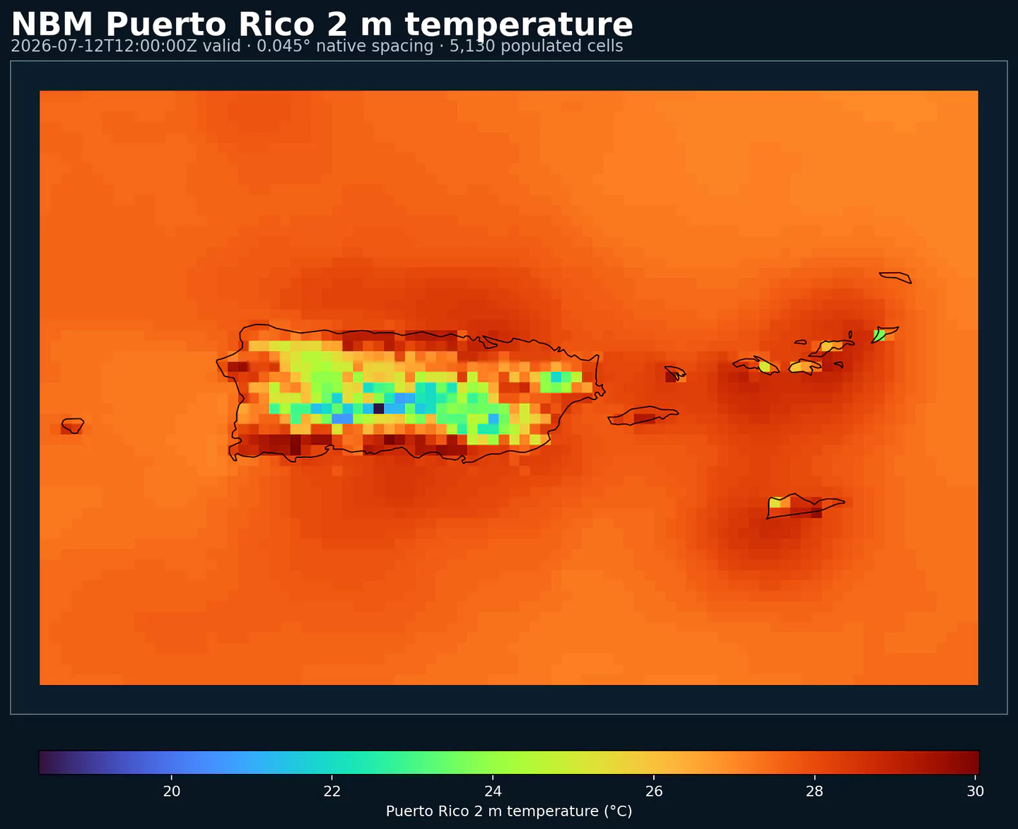
GribStream

NOAA National Blend of Models Parallel - Puerto Rico

Codice GribStream: nbmparpr

Altre griglie NBM Parallel: nbmpar, nbmparak, nbmparhi, nbmpargu, nbmparoc

Status: NBM v5 è già operativo in GribStream in nbmpr. In nbmpr, i run precedenti a 2026-05-05 12:00 UTC contengono la versione operativa precedente di NBM; i run da 2026-05-05 12:00 UTC in poi usano NBM v5. Per integrazioni di produzione con NBM v5 usa nbmpr; i dataset nbmpar* restano riservati a future iterazioni sperimentali di NBM se NOAA torna a pubblicarle nella linea parallela.

La fonte pubblica è noaa-nbm-para-pds. GribStream mantiene la linea parallela in codici dedicati, così puoi confrontarla con la famiglia NBM operativa senza mescolarla con l'archivio usato dalle integrazioni correnti.

Riferimenti tecnici: PNS 25-45, note di configurazione Winter v5.0 e NBM Versions.

Descrizione

NBM Parallel Puerto Rico è il prodotto pubblico parallelo del National Blend of Models per Puerto Rico. Serve a confronto e validazione quando NOAA pubblica una linea sperimentale accanto alla versione operativa.

Per produzione con NBM v5, il dataset consigliato è nbmpr. nbmparpr resta come riferimento di confronto e come spazio per future iterazioni sperimentali che NOAA potrebbe pubblicare nella linea parallela.

NBM v5 non è stato solo un aggiornamento di parametri. NOAA ha esteso gran parte della previsione oraria di base da 36 h a 48 h e ha rivisto il blend con più Quantile Mapping, modifiche a vento e raffiche deterministiche, e input a risoluzione più alta da ECMWF e Canada.

Per Puerto Rico, NBM v5 porta una finestra oraria più lunga, nuovi campi di vento e raffiche a 10 m con Quantile Mapping, e aggiornamenti più ampi di temperatura, umidità e temperatura apparente che rendono la serie calibrata più utile nel breve termine tropicale.

In GribStream, nbmparpr mantiene selettori stabili: i valori di name, level e info vengono copiati esattamente dal catalogo e non sono tradotti.

Dettagli

Dataset correlati

Parametri

0 parametri

Fai clic su un parametro per vedere le varianti in una tabella compatta con selettori JSON pronti da copiare. Codici, livelli e valori dei selettori restano esattamente come li espone l'API.

APCP –Accumulated Precipitation (kg/m^2)
2 variants

Accumulated precipitation represents the total water-equivalent amount of rain and snow during the output period. It is a primary field for hydrologic impacts and event totals.

  • Units: kg/m^2.
  • Use with the model time interval to interpret totals and compare to gauges.
Level Info Horizon Introduced Selector
surface 1h-264h 5 days ago
{"name":"APCP","level":"surface","info":""}
surface prob >0.254 1h-264h 5 days ago
{"name":"APCP","level":"surface","info":"prob >0.254"}
APTMP –Apparent Temperature (K)
1 variant

Apparent temperature combines air temperature, humidity, and wind to estimate how hot or cold it feels to humans. It is useful for heat and cold stress assessments.

  • Units: K.
Level Info Horizon Introduced Selector
2 m above ground 1h-264h 5 days ago
{"name":"APTMP","level":"2 m above ground","info":""}
CAPE –Convective Available Potential Energy (J/kg)
2 variants

Convective Available Potential Energy (CAPE) quantifies buoyant energy available to rising air parcels. Larger values generally imply stronger potential updrafts and greater convective intensity.

  • Units: J/kg.
  • Often used with CIN and lifting mechanisms to assess thunderstorm potential.
Level Info Horizon Introduced Selector
surface 1h-264h 5 days ago
{"name":"CAPE","level":"surface","info":""}
surface ens std dev 1h-264h 5 days ago
{"name":"CAPE","level":"surface","info":"ens std dev"}
CEIL –Ceiling Height (m)
2 variants

Ceiling height is the altitude of the lowest cloud base that covers a significant portion of the sky. It is a key aviation and surface-visibility metric.

  • Units: m.
Level Info Horizon Introduced Selector
cloud base 1h-84h 5 days ago
{"name":"CEIL","level":"cloud base","info":""}
cloud ceiling 1h-78h 5 days ago
{"name":"CEIL","level":"cloud ceiling","info":""}
DIST –Distance to Feature (km)
1 variant

Distance to feature is the horizontal distance to the named hazard or boundary in the source product. It is used to map proximity to key features like fronts or hazards.

  • Units: km.
Level Info Horizon Introduced Selector
surface - 610 m above ground 1h-36h 5 days ago
{"name":"DIST","level":"surface - 610 m above ground","info":""}
DPT –Dew Point Temperature (K)
2 variants

Dew point temperature is the temperature at which the air becomes saturated. It is a direct measure of moisture content.

  • Units: K.
  • When dew point is close to air temperature, fog or low cloud potential increases.
Level Info Horizon Introduced Selector
2 m above ground 1h-264h 5 days ago
{"name":"DPT","level":"2 m above ground","info":""}
2 m above ground ens std dev 1h-264h 5 days ago
{"name":"DPT","level":"2 m above ground","info":"ens std dev"}
DSWRF –Downward Short-Wave Radiation Flux (W/m^2)
1 variant

Downward radiative flux represents incoming energy at the surface. It is a key driver of surface heating and cooling.

  • Units: W/m^2.
  • Shortwave affects surface heating; longwave affects radiative cooling.
Level Info Horizon Introduced Selector
surface 1h-264h 5 days ago
{"name":"DSWRF","level":"surface","info":""}
ELLINX –Ellrod Index (unitless)
1 variant

Ellrod index is a diagnostic for clear-air turbulence based on deformation and vertical wind shear. Higher values indicate greater turbulence potential for aviation.

  • Units: unitless.
Level Info Horizon Introduced Selector
400-300 mb 1h-259h 5 days ago
{"name":"ELLINX","level":"400-300 mb","info":""}
FOSINDX –Fosberg Fire Weather Index (unitless)
1 variant

Fosberg fire weather index combines temperature, humidity, and wind to estimate potential fire spread. Higher values indicate more favorable wildfire conditions.

  • Units: unitless.
Level Info Horizon Introduced Selector
surface 6h-264h 5 days ago
{"name":"FOSINDX","level":"surface","info":""}
GUST –Wind Speed (Gust) (m/s)
2 variants

Wind gust is the peak short-duration wind speed. It captures brief, hazardous bursts that can exceed sustained winds.

  • Units: m/s.
Level Info Horizon Introduced Selector
10 m above ground 1h-264h 5 days ago
{"name":"GUST","level":"10 m above ground","info":""}
10 m above ground ens std dev 1h-264h 5 days ago
{"name":"GUST","level":"10 m above ground","info":"ens std dev"}
MAXREF –Hourly Maximum of Simulated Reflectivity at 1 km AGL (dBZ)
1 variant

Hourly maximum simulated reflectivity at 1 km AGL captures the strongest modeled reflectivity near the surface. It is used to identify peak convective intensity and heavy precipitation cores.

  • Units: dBZ.
Level Info Horizon Introduced Selector
1000 m above ground 1h-48h 5 days ago
{"name":"MAXREF","level":"1000 m above ground","info":""}
MAXRH –Maximum Relative Humidity (percent)
1 variant

Maximum relative humidity is the highest RH reached during the period. It can indicate peak cloud or fog potential.

  • Units: percent.
  • Higher values indicate more atmospheric moisture and greater cloud or precip potential.
Level Info Horizon Introduced Selector
2 m above ground 13h-264h 5 days ago
{"name":"MAXRH","level":"2 m above ground","info":""}
MINRH –Minimum Relative Humidity (percent)
1 variant

Minimum relative humidity is the lowest RH reached during the period. It is used in fire‑weather and drying assessments.

  • Units: percent.
  • Higher values indicate more atmospheric moisture and greater cloud or precip potential.
Level Info Horizon Introduced Selector
2 m above ground 13h-264h 5 days ago
{"name":"MINRH","level":"2 m above ground","info":""}
MIXHT –Mixing Height (m)
1 variant

Mixing height is the depth of the well-mixed layer near the surface. It is widely used for dispersion, smoke, and air-quality applications.

  • Units: m.
Level Info Horizon Introduced Selector
entire atmosphere (considered as a single layer) 1h-264h 5 days ago
{"name":"MIXHT","level":"entire atmosphere (considered as a single layer)","info":""}
PCPDUR –Precipitation Duration (hours)
1 variant

Precipitation duration is the total time with measurable precipitation in the output period. It helps distinguish intermittent from persistent events.

  • Units: hours.
  • Accumulations represent water-equivalent depth over the output interval; rates describe intensity.
Level Info Horizon Introduced Selector
surface 12h-36h 5 days ago
{"name":"PCPDUR","level":"surface","info":""}
PWAT –Precipitable Water (kg/m^2)
9 variants

Precipitable water is the total column water vapor from the surface to the top of the atmosphere. It is a key moisture indicator.

  • Units: kg/m^2.
Level Info Horizon Introduced Selector
entire atmosphere (considered as a single layer) 1h-264h 5 days ago
{"name":"PWAT","level":"entire atmosphere (considered as a single layer)","info":""}
entire atmosphere (considered as a single layer) 10% level 1h-264h 5 days ago
{"name":"PWAT","level":"entire atmosphere (considered as a single layer)","info":"10% level"}
entire atmosphere (considered as a single layer) 50% level 1h-264h 5 days ago
{"name":"PWAT","level":"entire atmosphere (considered as a single layer)","info":"50% level"}
entire atmosphere (considered as a single layer) 90% level 1h-264h 5 days ago
{"name":"PWAT","level":"entire atmosphere (considered as a single layer)","info":"90% level"}
entire atmosphere (considered as a single layer) prob >12.7 1h-264h 5 days ago
{"name":"PWAT","level":"entire atmosphere (considered as a single layer)","info":"prob >12.7"}
entire atmosphere (considered as a single layer) prob >25.4 1h-264h 5 days ago
{"name":"PWAT","level":"entire atmosphere (considered as a single layer)","info":"prob >25.4"}
entire atmosphere (considered as a single layer) prob >38.1 1h-264h 5 days ago
{"name":"PWAT","level":"entire atmosphere (considered as a single layer)","info":"prob >38.1"}
entire atmosphere (considered as a single layer) prob >50.8 1h-264h 5 days ago
{"name":"PWAT","level":"entire atmosphere (considered as a single layer)","info":"prob >50.8"}
entire atmosphere (considered as a single layer) prob >63.5 1h-264h 5 days ago
{"name":"PWAT","level":"entire atmosphere (considered as a single layer)","info":"prob >63.5"}
RETOP –Radar Echo Top Height (m)
1 variant

Echo top height is the altitude of the highest reflectivity in the column. It is a proxy for storm depth and convective vigor.

  • Units: m.
Level Info Horizon Introduced Selector
cloud top 1h-48h 5 days ago
{"name":"RETOP","level":"cloud top","info":""}
RH –Relative Humidity (percent)
1 variant

Relative humidity describes how close the air is to saturation at the specified level. High values favor cloud formation.

  • Units: percent.
  • Higher values indicate more atmospheric moisture and greater cloud or precip potential.
Level Info Horizon Introduced Selector
2 m above ground 1h-264h 5 days ago
{"name":"RH","level":"2 m above ground","info":""}
TCDC –Total Cloud Cover (percent)
3 variants

Total cloud cover is the fraction of the grid cell covered by clouds at any level. It influences radiation, temperature, and visibility.

  • Units: percent.
  • Cloud fraction influences surface radiation and temperature.
Level Info Horizon Introduced Selector
surface 1h-264h 5 days ago
{"name":"TCDC","level":"surface","info":""}
surface ens std dev 1h-48h 5 days ago
{"name":"TCDC","level":"surface","info":"ens std dev"}
surface unknown derived fcst 49h-264h 5 days ago
{"name":"TCDC","level":"surface","info":"unknown derived fcst"}
THUNC –Thunderstorm Probability (percent)
1 variant

Thunderstorm probability gives the chance of thunderstorms during the valid period. It is used for convective hazard guidance.

  • Units: percent.
Level Info Horizon Introduced Selector
entire atmosphere 1h-36h 5 days ago
{"name":"THUNC","level":"entire atmosphere","info":""}
TMAX –Maximum Temperature (K)
2 variants

Maximum temperature is the highest temperature reached during the output period. It is commonly used for heat stress and daily extremes.

  • Units: K.
Level Info Horizon Introduced Selector
2 m above ground 12h-264h 5 days ago
{"name":"TMAX","level":"2 m above ground","info":""}
2 m above ground ens std dev 12h-264h 5 days ago
{"name":"TMAX","level":"2 m above ground","info":"ens std dev"}
TMIN –Minimum Temperature (K)
2 variants

Minimum temperature is the lowest temperature reached during the output period. It is commonly used for frost and cold-stress assessment.

  • Units: K.
Level Info Horizon Introduced Selector
2 m above ground 12h-264h 5 days ago
{"name":"TMIN","level":"2 m above ground","info":""}
2 m above ground ens std dev 12h-264h 5 days ago
{"name":"TMIN","level":"2 m above ground","info":"ens std dev"}
TMP –Temperature (K)
2 variants

Air temperature is the thermal state of the atmosphere at the specified level. It influences density, stability, and energy exchange.

  • Units: K.
Level Info Horizon Introduced Selector
2 m above ground 1h-264h 5 days ago
{"name":"TMP","level":"2 m above ground","info":""}
2 m above ground ens std dev 1h-264h 5 days ago
{"name":"TMP","level":"2 m above ground","info":"ens std dev"}
TPWDIR –Total Precipitable Water Transport Direction (degrees)
1 variant

Total precipitable water transport direction is the direction of column‑integrated moisture flux. It indicates moisture transport pathways.

  • Units: degrees.
Level Info Horizon Introduced Selector
10 m above ground 1h-167h 5 days ago
{"name":"TPWDIR","level":"10 m above ground","info":""}
TPWSPD –Total Precipitable Water Transport Speed (m/s)
1 variant

Total precipitable water transport speed is the magnitude of column‑integrated moisture transport. It highlights atmospheric river strength.

  • Units: m/s.
Level Info Horizon Introduced Selector
10 m above ground 1h-167h 5 days ago
{"name":"TPWSPD","level":"10 m above ground","info":""}
TRWDIR –Tropical Wind Direction (degrees)
1 variant

Tropical wind direction is the direction of the tropical wind vector used in cyclone guidance.

  • Units: degrees.
Level Info Horizon Introduced Selector
entire atmosphere (considered as a single layer) 1h-264h 5 days ago
{"name":"TRWDIR","level":"entire atmosphere (considered as a single layer)","info":""}
TRWSPD –Tropical Wind Speed (m/s)
1 variant

Tropical wind speed is the magnitude of the tropical wind vector. It is often used in cyclone diagnostics.

  • Units: m/s.
Level Info Horizon Introduced Selector
entire atmosphere (considered as a single layer) 1h-264h 5 days ago
{"name":"TRWSPD","level":"entire atmosphere (considered as a single layer)","info":""}
TSTM –Thunderstorm Indicator (boolean)
1 variant

Thunderstorm indicator flags the presence of thunderstorm conditions in the grid cell. It is used as a categorical hazard field.

  • Units: boolean.
Level Info Horizon Introduced Selector
surface probability forecast 1h-192h 5 days ago
{"name":"TSTM","level":"surface","info":"probability forecast"}
TURB –Turbulence Index (unitless)
1 variant

Turbulence index is a diagnostic measure of aviation turbulence. Higher values indicate increased turbulence risk along flight routes.

  • Units: unitless.
Level Info Horizon Introduced Selector
surface - 1372 m above ground 1h-259h 5 days ago
{"name":"TURB","level":"surface - 1372 m above ground","info":""}
VIL –Vertically-Integrated Liquid Water (kg/m^2)
1 variant

Vertically‑integrated liquid water is the total column liquid water content. It is used as a proxy for precipitation intensity and hail potential.

  • Units: kg/m^2.
Level Info Horizon Introduced Selector
entire atmosphere 1h-48h 5 days ago
{"name":"VIL","level":"entire atmosphere","info":""}
VIS –Visibility (m)
1 variant

Horizontal visibility at the surface. Lower values indicate reduced visibility due to fog, precipitation, or aerosols.

  • Units: m.
Level Info Horizon Introduced Selector
surface 1h-79h 5 days ago
{"name":"VIS","level":"surface","info":""}
VRATE –Ventilation Rate (m^2/s)
1 variant

Ventilation rate combines mixing depth and transport wind to estimate the atmosphere's ability to disperse smoke and pollutants.

  • Units: m^2/s.
Level Info Horizon Introduced Selector
entire atmosphere (considered as a single layer) 1h-264h 5 days ago
{"name":"VRATE","level":"entire atmosphere (considered as a single layer)","info":""}
WDIR –Wind Direction (degrees)
4 variants

Wind direction indicates the direction from which the wind is blowing at the specified level.

  • Units: degrees.
Level Info Horizon Introduced Selector
10 m above ground 1h-264h 5 days ago
{"name":"WDIR","level":"10 m above ground","info":""}
30 m above ground 1h-264h 5 days ago
{"name":"WDIR","level":"30 m above ground","info":""}
80 m above ground 1h-264h 5 days ago
{"name":"WDIR","level":"80 m above ground","info":""}
surface - 610 m above ground 1h-36h 5 days ago
{"name":"WDIR","level":"surface - 610 m above ground","info":""}
WETGLBT –Wet Bulb Globe Temperature (K)
1 variant

Wet bulb globe temperature combines temperature, humidity, radiation, and wind effects into a single heat-stress metric. It is commonly used for outdoor exposure and occupational heat-risk assessment.

  • Units: K.
  • Use it as a composite heat-stress indicator rather than a standard air-temperature field.
Level Info Horizon Introduced Selector
surface 1h-264h 5 days ago
{"name":"WETGLBT","level":"surface","info":""}
WIND –Wind Speed (m/s)
5 variants

Wind speed is the magnitude of the horizontal wind at the specified level. It is used for transport, mixing, and hazards.

  • Units: m/s.
Level Info Horizon Introduced Selector
10 m above ground 1h-264h 5 days ago
{"name":"WIND","level":"10 m above ground","info":""}
10 m above ground ens std dev 1h-264h 5 days ago
{"name":"WIND","level":"10 m above ground","info":"ens std dev"}
30 m above ground 1h-264h 5 days ago
{"name":"WIND","level":"30 m above ground","info":""}
80 m above ground 1h-264h 5 days ago
{"name":"WIND","level":"80 m above ground","info":""}
surface - 610 m above ground 1h-36h 5 days ago
{"name":"WIND","level":"surface - 610 m above ground","info":""}

Nessun parametro corrisponde alla ricerca.