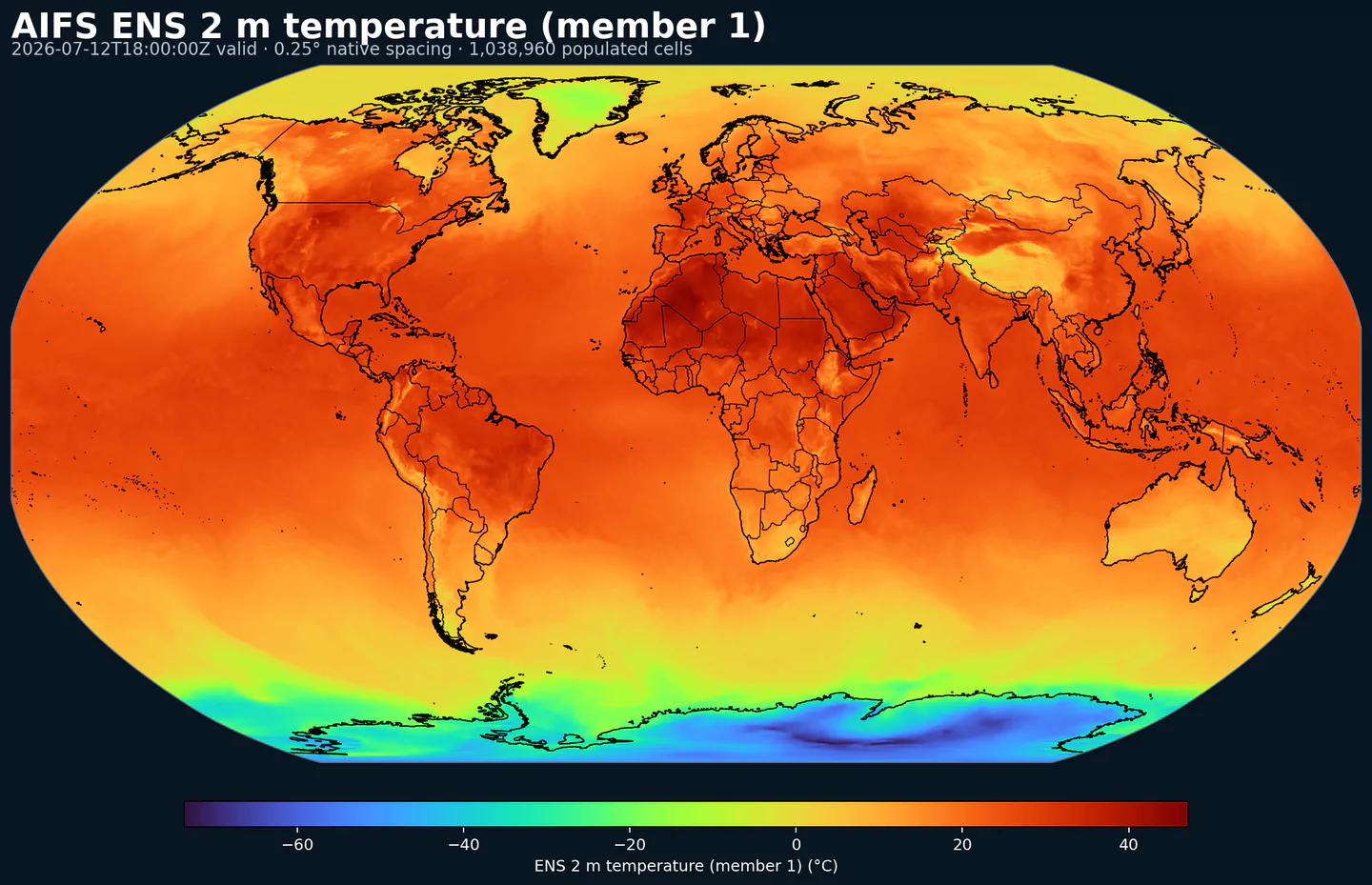
GribStream

ECMWF Artificial Intelligence/Integrated Forecasting System Ensemble (AIFS Ensemble)

GribStream Code: aifsenfo

Description

AIFS Ensemble is ECMWF’s AI-based probabilistic global forecast. It generates multiple members with a stochastic ML model trained on reanalysis and fine-tuned on operational analyses, then initializes member-for-member from the IFS Ensemble. The system is trained with a probabilistic objective (e.g., CRPS) to produce calibrated spread and skill. Outputs include standard surface variables and pressure-level fields (temperature, wind, humidity, geopotential, vertical velocity), plus ensemble statistics and event probabilities. Related suite: AIFS Oper.

Detail

Parameters

0 parameters

Click a parameter to reveal variants in a compact table with ready-to-copy JSON selectors.

100u –100 metre U wind component (m s-1)
1 variant

Parameter ID 228246

ECMWF param DB

Eastward component of the 100 m wind, describing near-surface flow aloft.

  • Comparisons to observations require care because observations represent point measurements rather than grid-box means.
  • Combine with the 100 m V component to derive wind speed and direction.
Level Info Horizon Introduced Selector
sfc 0h-360h 2025-07-02
{"name":"100u","level":"sfc","info":""}
100v –100 metre V wind component (m s-1)
1 variant

Parameter ID 228247

ECMWF param DB

Northward component of the 100 m wind, describing near-surface flow aloft.

  • Comparisons to observations require care because observations represent point measurements rather than grid-box means.
  • Combine with the 100 m U component to derive wind speed and direction.
Level Info Horizon Introduced Selector
sfc 0h-360h 2025-07-02
{"name":"100v","level":"sfc","info":""}
10u –10 metre U wind component (m s-1)
1 variant

Parameter ID 165

ECMWF param DB

Eastward (U) component of near-surface wind.

  • Combine with the 10 m V component to derive wind speed and direction.
  • Observations can diverge due to terrain, vegetation, and local exposure.
Level Info Horizon Introduced Selector
sfc 0h-360h 2025-07-02
{"name":"10u","level":"sfc","info":""}
10v –10 metre V wind component (m s-1)
1 variant

Parameter ID 166

ECMWF param DB

Northward (V) component of near-surface wind.

  • Combine with the 10 m U component to derive wind speed and direction.
  • Observations can diverge due to terrain, vegetation, and local exposure.
Level Info Horizon Introduced Selector
sfc 0h-360h 2025-07-02
{"name":"10v","level":"sfc","info":""}
2d –2 metre dewpoint temperature (K)
1 variant

Parameter ID 168

ECMWF param DB

Dewpoint temperature describing near-surface moisture conditions. Useful for humidity diagnostics.

  • Often combined with temperature and pressure to estimate relative humidity.
  • Computed by interpolating between the lowest model level and the surface.
Level Info Horizon Introduced Selector
sfc 0h-360h 2025-07-02
{"name":"2d","level":"sfc","info":""}
2t –2 metre temperature (K)
1 variant

Parameter ID 167

ECMWF param DB

Near-surface air temperature representative of conditions over land, sea, or inland waters. Derived using surface and lowest model level information.

  • Units are kelvin (K); to convert to degrees Celsius (deg C), subtract 273.15.
  • Mean 2 metre temperature is encoded separately (parameter 228004).
Level Info Horizon Introduced Selector
sfc 0h-360h 2025-07-02
{"name":"2t","level":"sfc","info":""}
hcc –High cloud cover ((0 - 1))
1 variant

Parameter ID 188

ECMWF param DB

Fraction of a grid box covered by high-level cloud.

  • Computed from model levels with pressure < 0.45 of surface pressure (~6 km and above).
  • Cloud fractions range from 0 to 1; overlap assumptions are applied across levels.
  • See parameter 3075 for the equivalent value in percent.
Level Info Horizon Introduced Selector
sfc 0h-360h 2025-07-02
{"name":"hcc","level":"sfc","info":""}
lcc –Low cloud cover ((0 - 1))
1 variant

Parameter ID 186

ECMWF param DB

Fraction of a grid box covered by low-level cloud.

  • Computed from model levels with pressure > 0.8 of surface pressure (~2 km and below).
  • Cloud fractions range from 0 to 1; overlap assumptions are applied across levels.
  • See parameter 3073 for the equivalent value in percent.
Level Info Horizon Introduced Selector
sfc 0h-360h 2025-07-02
{"name":"lcc","level":"sfc","info":""}
lsm –Land-sea mask ((0 - 1))
1 variant

Parameter ID 172

ECMWF param DB

Fraction of land within a grid box relative to ocean and inland waters.

  • Values range from 0 to 1 and are dimensionless.
  • From IFS CY41R1 (May 2015), grid boxes >0.5 may mix land and inland water; <=0.5 are water only.
  • Before CY41R1, >0.5 implied land only; <=0.5 implied ocean only (no inland water differentiation).
Level Info Horizon Introduced Selector
sfc 0h 2025-07-02
{"name":"lsm","level":"sfc","info":""}
msl –Mean sea level pressure (Pa)
1 variant

Parameter ID 151

ECMWF param DB

Atmospheric pressure adjusted to mean sea level, reflecting the weight of the air column.

  • Maps of mean sea level pressure highlight cyclones, anticyclones, and wind strength via contour spacing.
  • Often expressed in hPa or millibars (1 hPa = 1 mb = 100 Pa).
Level Info Horizon Introduced Selector
sfc 0h-360h 2025-07-02
{"name":"msl","level":"sfc","info":""}
q –Specific humidity (kg kg-1)
13 variants

Parameter ID 133

ECMWF param DB

Mass of water vapour per kilogram of moist air.

  • Moist air includes dry air, water vapour, cloud liquid, cloud ice, rain, and falling snow.
Level Info Horizon Introduced Selector
pl 100 0h-360h 2025-07-02
{"name":"q","level":"pl 100","info":""}
pl 1000 0h-360h 2025-07-02
{"name":"q","level":"pl 1000","info":""}
pl 150 0h-360h 2025-07-02
{"name":"q","level":"pl 150","info":""}
pl 200 0h-360h 2025-07-02
{"name":"q","level":"pl 200","info":""}
pl 250 0h-360h 2025-07-02
{"name":"q","level":"pl 250","info":""}
pl 300 0h-360h 2025-07-02
{"name":"q","level":"pl 300","info":""}
pl 400 0h-360h 2025-07-02
{"name":"q","level":"pl 400","info":""}
pl 50 0h-360h 2025-07-02
{"name":"q","level":"pl 50","info":""}
pl 500 0h-360h 2025-07-02
{"name":"q","level":"pl 500","info":""}
pl 600 0h-360h 2025-07-02
{"name":"q","level":"pl 600","info":""}
pl 700 0h-360h 2025-07-02
{"name":"q","level":"pl 700","info":""}
pl 850 0h-360h 2025-07-02
{"name":"q","level":"pl 850","info":""}
pl 925 0h-360h 2025-07-02
{"name":"q","level":"pl 925","info":""}
rowe –Runoff water equivalent (surface plus subsurface) (kg m-2)
1 variant

Parameter ID 231002

ECMWF param DB

Total surface + subsurface runoff accumulated over the output period, expressed as water equivalent mass.

  • Useful for drought/flood assessment; comparisons to observations require care due to scale differences.
  • See parameter 205 for the equivalent value expressed in metres.
Level Info Horizon Introduced Selector
sfc 0h-360h 2025-07-02
{"name":"rowe","level":"sfc","info":""}
sdor –Standard deviation of sub-gridscale orography (m)
1 variant

Parameter ID 160

ECMWF param DB

Standard deviation of sub-grid orography within a grid box (valleys, hills, and mountains below model resolution).

  • Derived from ~1 km land-surface data for features between 5 km and the model grid resolution.
  • Used by the sub-grid orography scheme for low-level blocking and gravity-wave drag.
Level Info Horizon Introduced Selector
sfc 0h 2025-07-02
{"name":"sdor","level":"sfc","info":""}
sf –Snowfall (m of water equivalent)
1 variant

Parameter ID 144

ECMWF param DB

Accumulated snowfall at the surface (large-scale + convective).

  • Accumulated over the extraction period; depth in metres of water equivalent.
  • See parameter 228144 for the equivalent value expressed in kg m-2.
Level Info Horizon Introduced Selector
sfc 0h-360h 2025-07-02
{"name":"sf","level":"sfc","info":""}
skt –Skin temperature (K)
1 variant

Parameter ID 235

ECMWF param DB

Temperature of the Earth's surface required to satisfy the surface energy balance.

  • Represents the uppermost surface layer with no heat capacity, so it responds instantly to surface flux changes.
  • Computed differently over land and sea.
  • Units are kelvin (K); to convert to degrees Celsius (deg C), subtract 273.15.
  • Mean skin temperature is encoded separately (parameter 235079).
Level Info Horizon Introduced Selector
sfc 0h-360h 2025-07-02
{"name":"skt","level":"sfc","info":""}
slor –Slope of sub-gridscale orography (Numeric)
1 variant

Parameter ID 163

ECMWF param DB

Slope metric for sub-grid orography derived from ~1 km terrain data.

  • Represents slopes of valleys, hills, and mountains unresolved by the model grid.
  • A flat surface has value 0; a 45° slope corresponds to 0.5.
Level Info Horizon Introduced Selector
sfc 0h 2025-07-02
{"name":"slor","level":"sfc","info":""}
sot –Soil temperature (K)
2 variants
Level Info Horizon Introduced Selector
sol 1 0h-360h 2025-07-02
{"name":"sot","level":"sol 1","info":""}
sol 2 0h-360h 2025-07-02
{"name":"sot","level":"sol 2","info":""}
sp –Surface pressure (Pa)
1 variant

Parameter ID 134

ECMWF param DB

Atmospheric pressure at the surface of land, sea, and inland water.

  • Often used with temperature to estimate air density.
  • Mean sea level pressure is typically preferred for identifying large-scale pressure systems in mountainous regions.
  • Often expressed in hPa or millibars (1 hPa = 1 mb = 100 Pa).
Level Info Horizon Introduced Selector
sfc 0h-360h 2025-07-02
{"name":"sp","level":"sfc","info":""}
ssrd –Surface short-wave (solar) radiation downwards (J m-2)
1 variant

Parameter ID 169

ECMWF param DB

Downward shortwave radiation at the surface (direct + diffuse).

  • Approximate model equivalent of pyranometer measurements.
  • Accumulated over the extraction period; divide by seconds to convert to W m-2.
  • ECMWF convention for vertical fluxes is positive downward.
Level Info Horizon Introduced Selector
sfc 0h-360h 2025-07-02
{"name":"ssrd","level":"sfc","info":""}
strd –Surface long-wave (thermal) radiation downwards (J m-2)
1 variant

Parameter ID 175

ECMWF param DB

Downward longwave radiation at the surface emitted by the atmosphere and clouds.

  • Accumulated over the extraction period; divide by seconds to convert to W m-2.
  • ECMWF convention for vertical fluxes is positive downward.
Level Info Horizon Introduced Selector
sfc 0h-360h 2025-07-02
{"name":"strd","level":"sfc","info":""}
t –Temperature (K)
13 variants

Parameter ID 130

ECMWF param DB

Air temperature throughout the atmosphere.

  • Units are kelvin (K); to convert to degrees Celsius (deg C), subtract 273.15.
  • Available on multiple vertical levels.
Level Info Horizon Introduced Selector
pl 100 0h-360h 2025-07-02
{"name":"t","level":"pl 100","info":""}
pl 1000 0h-360h 2025-07-02
{"name":"t","level":"pl 1000","info":""}
pl 150 0h-360h 2025-07-02
{"name":"t","level":"pl 150","info":""}
pl 200 0h-360h 2025-07-02
{"name":"t","level":"pl 200","info":""}
pl 250 0h-360h 2025-07-02
{"name":"t","level":"pl 250","info":""}
pl 300 0h-360h 2025-07-02
{"name":"t","level":"pl 300","info":""}
pl 400 0h-360h 2025-07-02
{"name":"t","level":"pl 400","info":""}
pl 50 0h-360h 2025-07-02
{"name":"t","level":"pl 50","info":""}
pl 500 0h-360h 2025-07-02
{"name":"t","level":"pl 500","info":""}
pl 600 0h-360h 2025-07-02
{"name":"t","level":"pl 600","info":""}
pl 700 0h-360h 2025-07-02
{"name":"t","level":"pl 700","info":""}
pl 850 0h-360h 2025-07-02
{"name":"t","level":"pl 850","info":""}
pl 925 0h-360h 2025-07-02
{"name":"t","level":"pl 925","info":""}
tcc –Total cloud cover ((0 - 1))
1 variant

Parameter ID 164

ECMWF param DB

Fraction of a grid box covered by cloud across all model levels.

  • Computed from cloud across different heights with overlap assumptions.
  • See parameter 228164 for the equivalent value in percent.
Level Info Horizon Introduced Selector
sfc 0h-360h 2025-07-02
{"name":"tcc","level":"sfc","info":""}
tcw –Total column water (kg m-2)
1 variant

Parameter ID 136

ECMWF param DB

Total column water including vapour, liquid water, cloud ice, rain, and snow.

  • Older IFS versions did not include rain and snow in the total.
Level Info Horizon Introduced Selector
sfc 0h-360h 2025-07-02
{"name":"tcw","level":"sfc","info":""}
tp –Total precipitation (m)
1 variant

Parameter ID 228

ECMWF param DB

Accumulated rain + snow at the surface (large-scale + convective).

  • Does not include fog, dew, or precipitation that evaporates before reaching the surface.
  • Accumulated over the extraction period; depth in metres of water equivalent.
  • See parameter 228228 for the equivalent value expressed in kg m-2.
Level Info Horizon Introduced Selector
sfc 0h-360h 2025-07-02
{"name":"tp","level":"sfc","info":""}
u –U component of wind (m s-1)
13 variants

Parameter ID 131

ECMWF param DB

Eastward wind component; negative values indicate westward flow.

  • Combine with the V component to derive wind speed and direction.
Level Info Horizon Introduced Selector
pl 100 0h-360h 2025-07-02
{"name":"u","level":"pl 100","info":""}
pl 1000 0h-360h 2025-07-02
{"name":"u","level":"pl 1000","info":""}
pl 150 0h-360h 2025-07-02
{"name":"u","level":"pl 150","info":""}
pl 200 0h-360h 2025-07-02
{"name":"u","level":"pl 200","info":""}
pl 250 0h-360h 2025-07-02
{"name":"u","level":"pl 250","info":""}
pl 300 0h-360h 2025-07-02
{"name":"u","level":"pl 300","info":""}
pl 400 0h-360h 2025-07-02
{"name":"u","level":"pl 400","info":""}
pl 50 0h-360h 2025-07-02
{"name":"u","level":"pl 50","info":""}
pl 500 0h-360h 2025-07-02
{"name":"u","level":"pl 500","info":""}
pl 600 0h-360h 2025-07-02
{"name":"u","level":"pl 600","info":""}
pl 700 0h-360h 2025-07-02
{"name":"u","level":"pl 700","info":""}
pl 850 0h-360h 2025-07-02
{"name":"u","level":"pl 850","info":""}
pl 925 0h-360h 2025-07-02
{"name":"u","level":"pl 925","info":""}
v –V component of wind (m s-1)
13 variants

Parameter ID 132

ECMWF param DB

Northward wind component; negative values indicate southward flow.

  • Combine with the U component to derive wind speed and direction.
Level Info Horizon Introduced Selector
pl 100 0h-360h 2025-07-02
{"name":"v","level":"pl 100","info":""}
pl 1000 0h-360h 2025-07-02
{"name":"v","level":"pl 1000","info":""}
pl 150 0h-360h 2025-07-02
{"name":"v","level":"pl 150","info":""}
pl 200 0h-360h 2025-07-02
{"name":"v","level":"pl 200","info":""}
pl 250 0h-360h 2025-07-02
{"name":"v","level":"pl 250","info":""}
pl 300 0h-360h 2025-07-02
{"name":"v","level":"pl 300","info":""}
pl 400 0h-360h 2025-07-02
{"name":"v","level":"pl 400","info":""}
pl 50 0h-360h 2025-07-02
{"name":"v","level":"pl 50","info":""}
pl 500 0h-360h 2025-07-02
{"name":"v","level":"pl 500","info":""}
pl 600 0h-360h 2025-07-02
{"name":"v","level":"pl 600","info":""}
pl 700 0h-360h 2025-07-02
{"name":"v","level":"pl 700","info":""}
pl 850 0h-360h 2025-07-02
{"name":"v","level":"pl 850","info":""}
pl 925 0h-360h 2025-07-02
{"name":"v","level":"pl 925","info":""}
w –Vertical velocity (Pa s-1)
13 variants

Parameter ID 135

ECMWF param DB

Vertical motion in pressure coordinates; negative values indicate upward motion.

  • Useful for diagnosing large-scale ascent (negative) and subsidence (positive).
Level Info Horizon Introduced Selector
pl 100 0h-360h 2025-07-02
{"name":"w","level":"pl 100","info":""}
pl 1000 0h-360h 2025-07-02
{"name":"w","level":"pl 1000","info":""}
pl 150 0h-360h 2025-07-02
{"name":"w","level":"pl 150","info":""}
pl 200 0h-360h 2025-07-02
{"name":"w","level":"pl 200","info":""}
pl 250 0h-360h 2025-07-02
{"name":"w","level":"pl 250","info":""}
pl 300 0h-360h 2025-07-02
{"name":"w","level":"pl 300","info":""}
pl 400 0h-360h 2025-07-02
{"name":"w","level":"pl 400","info":""}
pl 50 0h-360h 2025-07-02
{"name":"w","level":"pl 50","info":""}
pl 500 0h-360h 2025-07-02
{"name":"w","level":"pl 500","info":""}
pl 600 0h-360h 2025-07-02
{"name":"w","level":"pl 600","info":""}
pl 700 0h-360h 2025-07-02
{"name":"w","level":"pl 700","info":""}
pl 850 0h-360h 2025-07-02
{"name":"w","level":"pl 850","info":""}
pl 925 0h-360h 2025-07-02
{"name":"w","level":"pl 925","info":""}
z –Geopotential (m2 s-2)
14 variants

Parameter ID 129

ECMWF param DB

Gravitational potential energy per unit mass relative to mean sea level.

  • Geopotential height = geopotential / g (9.80665 m s-2).
  • At the surface, reflects orography (geopotential height of the surface).
  • Constant-pressure charts of geopotential height are key for synoptic analysis.
Level Info Horizon Introduced Selector
pl 100 0h-360h 2025-07-02
{"name":"z","level":"pl 100","info":""}
pl 1000 0h-360h 2025-07-02
{"name":"z","level":"pl 1000","info":""}
pl 150 0h-360h 2025-07-02
{"name":"z","level":"pl 150","info":""}
pl 200 0h-360h 2025-07-02
{"name":"z","level":"pl 200","info":""}
pl 250 0h-360h 2025-07-02
{"name":"z","level":"pl 250","info":""}
pl 300 0h-360h 2025-07-02
{"name":"z","level":"pl 300","info":""}
pl 400 0h-360h 2025-07-02
{"name":"z","level":"pl 400","info":""}
pl 50 0h-360h 2025-07-02
{"name":"z","level":"pl 50","info":""}
pl 500 0h-360h 2025-07-02
{"name":"z","level":"pl 500","info":""}
pl 600 0h-360h 2025-07-02
{"name":"z","level":"pl 600","info":""}
pl 700 0h-360h 2025-07-02
{"name":"z","level":"pl 700","info":""}
pl 850 0h-360h 2025-07-02
{"name":"z","level":"pl 850","info":""}
pl 925 0h-360h 2025-07-02
{"name":"z","level":"pl 925","info":""}
sfc 0h 2025-07-02
{"name":"z","level":"sfc","info":""}

No parameters match your search.