GribStream-Code: aifsenfo
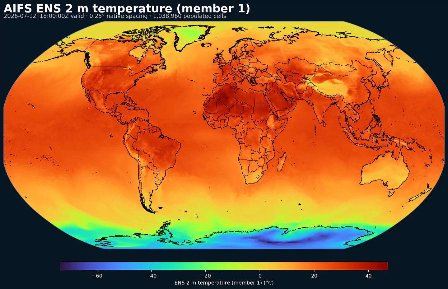
AIFS ENS member 1 2 m temperature across its complete 0.25 degree global grid, with black country boundaries. This plot was generated from the aifsenfo dataset.
Beschreibung
AIFS Ensemble ist das globale KI-basierte Ensemble von ECMWF. Es erweitert den Ansatz von AIFS Oper in Richtung probabilistische Vorhersage und erzeugt mehrere Mitglieder, um mittelfristige Unsicherheit abzubilden.
Das System nutzt ein stochastisches Machine-Learning-Modell, das mit ERA5 und operativen IFS-Analysen trainiert wurde. Die Mitglieder werden passend zu IFS Ensemble initialisiert, was den Vergleich zwischen KI-basierter und physikalischer Vorhersage erleichtert.
AIFS Ensemble nutzt probabilistisches Training auf Basis von CRPS, einer Metrik zur Bewertung von Vorhersageverteilungen, um kalibrierten Spread und guten probabilistischen Skill zu erreichen. Die Ausgabe enthält Standard-Oberflächenvariablen, Drucklevel-Felder, Ensemble-Statistiken und Ereigniswahrscheinlichkeiten.
In GribStream ist aifsenfo nützlich, wenn Sie ein globales probabilistisches KI-basiertes Dataset benötigen, besonders für Vergleiche gegen IFS ENS , AIFS Oper oder KI-basierte Modelle wie GraphCast.
Details
Archiv seit: 2025-07-02Produktseite: https://www.ecmwf.int/en/forecasts/datasets/open-data Wichtigste Merkmale:
Globales KI-basiertes Ensemble mit 51 Mitgliedern pro Lauf.
Stochastisches Machine-Learning-Modell, trainiert mit ERA5 und operativen IFS-Analysen.
Member-for-member-Initialisierung aus IFS Ensemble.
6-h-Schritte bis 360 h auf einem globalen 0.25-Grad-Grid.
Oberflächenfelder, Drucklevel-Felder, Ensemble-Statistiken und Ereigniswahrscheinlichkeiten.
Auflösung: Globales 0.25-Grad-Grid in der Open-Data-Auswahl.Zeitliche Abdeckung: Läufe um 00, 06, 12 und 18 UTC; 6-h-Schritte mit Dataset-Abdeckung bis 360 h.Hauptanwendungen: Globale probabilistische Vorhersagebasis, Risikoquantifizierung, Vergleich mit physikalischen Ensembles, Forschung zu Extremereignissen und Produkte, die Unsicherheit mit geringerem Rechenaufwand benötigen.
Verwandte Datasets
Parameter
Klicken Sie auf einen Parameter, um Varianten in einer kompakten Tabelle mit kopierbaren JSON-Selektoren zu sehen. Codes, Levels und Selector-Werte bleiben exakt so, wie die API sie ausgibt.
100u
– 100 metre U wind component (m s-1)
1 variant
Eastward component of the 100 m wind, describing near-surface flow aloft.
Comparisons to observations require care because observations represent point measurements rather than grid-box means.
Combine with the 100 m V component to derive wind speed and direction.
Level
Info
Horizon
Introduced
Selector
sfc0h-360h
2025-07-02
{"name":"100u","level":"sfc","info":""}
Copy
100v
– 100 metre V wind component (m s-1)
1 variant
Northward component of the 100 m wind, describing near-surface flow aloft.
Comparisons to observations require care because observations represent point measurements rather than grid-box means.
Combine with the 100 m U component to derive wind speed and direction.
Level
Info
Horizon
Introduced
Selector
sfc0h-360h
2025-07-02
{"name":"100v","level":"sfc","info":""}
Copy
10u
– 10 metre U wind component (m s-1)
1 variant
Eastward (U) component of near-surface wind.
Combine with the 10 m V component to derive wind speed and direction.
Observations can diverge due to terrain, vegetation, and local exposure.
Level
Info
Horizon
Introduced
Selector
sfc0h-360h
2025-07-02
{"name":"10u","level":"sfc","info":""}
Copy
10v
– 10 metre V wind component (m s-1)
1 variant
Northward (V) component of near-surface wind.
Combine with the 10 m U component to derive wind speed and direction.
Observations can diverge due to terrain, vegetation, and local exposure.
Level
Info
Horizon
Introduced
Selector
sfc0h-360h
2025-07-02
{"name":"10v","level":"sfc","info":""}
Copy
2d
– 2 metre dewpoint temperature (K)
1 variant
Dewpoint temperature describing near-surface moisture conditions. Useful for humidity diagnostics.
Often combined with temperature and pressure to estimate relative humidity.
Computed by interpolating between the lowest model level and the surface.
Level
Info
Horizon
Introduced
Selector
sfc0h-360h
2025-07-02
{"name":"2d","level":"sfc","info":""}
Copy
2t
– 2 metre temperature (K)
1 variant
Near-surface air temperature representative of conditions over land, sea, or inland waters. Derived using surface and lowest model level information.
Units are kelvin (K); to convert to degrees Celsius (deg C), subtract 273.15.
Mean 2 metre temperature is encoded separately (parameter 228004).
Level
Info
Horizon
Introduced
Selector
sfc0h-360h
2025-07-02
{"name":"2t","level":"sfc","info":""}
Copy
cp
– Convective precipitation (m)
1 variant
Accumulated precipitation from the convection scheme (rain + snow).
Does not include fog, dew, or precipitation that evaporates before reaching the surface.
Accumulated over the extraction period; depth in metres of water equivalent.
See parameter 228143 for the equivalent value expressed in kg m-2.
Level
Info
Horizon
Introduced
Selector
sfc0h-360h
2026-05-12
{"name":"cp","level":"sfc","info":""}
Copy
fscov
– Fraction of snow cover (dimensionless)
1 variant
Fraction of natural land in the grid box covered by snow.
The field describes snow cover over natural land, not a separate water-equivalent snow depth.
Level
Info
Horizon
Introduced
Selector
sfc0h-360h
2026-05-12
{"name":"fscov","level":"sfc","info":""}
Copy
hcc
– High cloud cover ((0 - 1))
1 variant
Fraction of a grid box covered by high-level cloud.
Computed from model levels with pressure < 0.45 of surface pressure (~6 km and above).
Cloud fractions range from 0 to 1; overlap assumptions are applied across levels.
See parameter 3075 for the equivalent value in percent.
Level
Info
Horizon
Introduced
Selector
sfc0h-360h
2025-07-02
{"name":"hcc","level":"sfc","info":""}
Copy
lcc
– Low cloud cover ((0 - 1))
1 variant
Fraction of a grid box covered by low-level cloud.
Computed from model levels with pressure > 0.8 of surface pressure (~2 km and below).
Cloud fractions range from 0 to 1; overlap assumptions are applied across levels.
See parameter 3073 for the equivalent value in percent.
Level
Info
Horizon
Introduced
Selector
sfc0h-360h
2025-07-02
{"name":"lcc","level":"sfc","info":""}
Copy
lsm
– Land-sea mask ((0 - 1))
1 variant
Fraction of land within a grid box relative to ocean and inland waters.
Values range from 0 to 1 and are dimensionless.
From IFS CY41R1 (May 2015), grid boxes >0.5 may mix land and inland water; <=0.5 are water only.
Before CY41R1, >0.5 implied land only; <=0.5 implied ocean only (no inland water differentiation).
Level
Info
Horizon
Introduced
Selector
sfc0h
2025-07-02
{"name":"lsm","level":"sfc","info":""}
Copy
mcc
– Medium cloud cover ((0 - 1))
1 variant
Fraction of a grid box covered by medium-level cloud.
Computed from model levels between the low- and high-cloud pressure thresholds.
Cloud fractions range from 0 to 1; overlap assumptions are applied across levels.
See parameter 3074 for the equivalent value in percent.
Level
Info
Horizon
Introduced
Selector
sfc0h-360h
2025-07-02
{"name":"mcc","level":"sfc","info":""}
Copy
msl
– Mean sea level pressure (Pa)
1 variant
Atmospheric pressure adjusted to mean sea level, reflecting the weight of the air column.
Maps of mean sea level pressure highlight cyclones, anticyclones, and wind strength via contour spacing.
Often expressed in hPa or millibars (1 hPa = 1 mb = 100 Pa).
Level
Info
Horizon
Introduced
Selector
sfc0h-360h
2025-07-02
{"name":"msl","level":"sfc","info":""}
Copy
q
– Specific humidity (kg kg-1)
13 variants
Mass of water vapour per kilogram of moist air.
Moist air includes dry air, water vapour, cloud liquid, cloud ice, rain, and falling snow.
Level
Info
Horizon
Introduced
Selector
pl 1000h-360h
2025-07-02
{"name":"q","level":"pl 100","info":""}
Copy
pl 10000h-360h
2025-07-02
{"name":"q","level":"pl 1000","info":""}
Copy
pl 1500h-360h
2025-07-02
{"name":"q","level":"pl 150","info":""}
Copy
pl 2000h-360h
2025-07-02
{"name":"q","level":"pl 200","info":""}
Copy
pl 2500h-360h
2025-07-02
{"name":"q","level":"pl 250","info":""}
Copy
pl 3000h-360h
2025-07-02
{"name":"q","level":"pl 300","info":""}
Copy
pl 4000h-360h
2025-07-02
{"name":"q","level":"pl 400","info":""}
Copy
pl 500h-360h
2025-07-02
{"name":"q","level":"pl 50","info":""}
Copy
pl 5000h-360h
2025-07-02
{"name":"q","level":"pl 500","info":""}
Copy
pl 6000h-360h
2025-07-02
{"name":"q","level":"pl 600","info":""}
Copy
pl 7000h-360h
2025-07-02
{"name":"q","level":"pl 700","info":""}
Copy
pl 8500h-360h
2025-07-02
{"name":"q","level":"pl 850","info":""}
Copy
pl 9250h-360h
2025-07-02
{"name":"q","level":"pl 925","info":""}
Copy
rowe
– Runoff water equivalent (surface plus subsurface) (kg m-2)
1 variant
Total surface + subsurface runoff accumulated over the output period, expressed as water equivalent mass.
Useful for drought/flood assessment; comparisons to observations require care due to scale differences.
See parameter 205 for the equivalent value expressed in metres.
Level
Info
Horizon
Introduced
Selector
sfc0h-360h
2025-07-02
{"name":"rowe","level":"sfc","info":""}
Copy
sdor
– Standard deviation of sub-gridscale orography (m)
1 variant
Standard deviation of sub-grid orography within a grid box (valleys, hills, and mountains below model resolution).
Derived from ~1 km land-surface data for features between 5 km and the model grid resolution.
Used by the sub-grid orography scheme for low-level blocking and gravity-wave drag.
Level
Info
Horizon
Introduced
Selector
sfc0h
2025-07-02
{"name":"sdor","level":"sfc","info":""}
Copy
sf
– Snowfall (m of water equivalent)
1 variant
Accumulated snowfall at the surface (large-scale + convective).
Accumulated over the extraction period; depth in metres of water equivalent.
See parameter 228144 for the equivalent value expressed in kg m-2.
Level
Info
Horizon
Introduced
Selector
sfc0h-360h
2025-07-02
{"name":"sf","level":"sfc","info":""}
Copy
skt
– Skin temperature (K)
1 variant
Temperature of the Earth's surface required to satisfy the surface energy balance.
Represents the uppermost surface layer with no heat capacity, so it responds instantly to surface flux changes.
Computed differently over land and sea.
Units are kelvin (K); to convert to degrees Celsius (deg C), subtract 273.15.
Mean skin temperature is encoded separately (parameter 235079).
Level
Info
Horizon
Introduced
Selector
sfc0h-360h
2025-07-02
{"name":"skt","level":"sfc","info":""}
Copy
slor
– Slope of sub-gridscale orography (Numeric)
1 variant
Slope metric for sub-grid orography derived from ~1 km terrain data.
Represents slopes of valleys, hills, and mountains unresolved by the model grid.
A flat surface has value 0; a 45° slope corresponds to 0.5.
Level
Info
Horizon
Introduced
Selector
sfc0h
2025-07-02
{"name":"slor","level":"sfc","info":""}
Copy
sot
– Soil temperature (K)
2 variants
Soil temperature.
Level
Info
Horizon
Introduced
Selector
sol 10h-360h
2025-07-02
{"name":"sot","level":"sol 1","info":""}
Copy
sol 20h-360h
2025-07-02
{"name":"sot","level":"sol 2","info":""}
Copy
sp
– Surface pressure (Pa)
1 variant
Atmospheric pressure at the surface of land, sea, and inland water.
Often used with temperature to estimate air density.
Mean sea level pressure is typically preferred for identifying large-scale pressure systems in mountainous regions.
Often expressed in hPa or millibars (1 hPa = 1 mb = 100 Pa).
Level
Info
Horizon
Introduced
Selector
sfc0h-360h
2025-07-02
{"name":"sp","level":"sfc","info":""}
Copy
ssrd
– Surface short-wave (solar) radiation downwards (J m-2)
1 variant
Downward shortwave radiation at the surface (direct + diffuse).
Approximate model equivalent of pyranometer measurements.
Accumulated over the extraction period; divide by seconds to convert to W m-2.
ECMWF convention for vertical fluxes is positive downward.
Level
Info
Horizon
Introduced
Selector
sfc0h-360h
2025-07-02
{"name":"ssrd","level":"sfc","info":""}
Copy
strd
– Surface long-wave (thermal) radiation downwards (J m-2)
1 variant
Downward longwave radiation at the surface emitted by the atmosphere and clouds.
Accumulated over the extraction period; divide by seconds to convert to W m-2.
ECMWF convention for vertical fluxes is positive downward.
Level
Info
Horizon
Introduced
Selector
sfc0h-360h
2025-07-02
{"name":"strd","level":"sfc","info":""}
Copy
t
– Temperature (K)
14 variants
Air temperature throughout the atmosphere.
Units are kelvin (K); to convert to degrees Celsius (deg C), subtract 273.15.
Available on multiple vertical levels.
Level
Info
Horizon
Introduced
Selector
pl 100h-360h
2026-05-12
{"name":"t","level":"pl 10","info":""}
Copy
pl 1000h-360h
2025-07-02
{"name":"t","level":"pl 100","info":""}
Copy
pl 10000h-360h
2025-07-02
{"name":"t","level":"pl 1000","info":""}
Copy
pl 1500h-360h
2025-07-02
{"name":"t","level":"pl 150","info":""}
Copy
pl 2000h-360h
2025-07-02
{"name":"t","level":"pl 200","info":""}
Copy
pl 2500h-360h
2025-07-02
{"name":"t","level":"pl 250","info":""}
Copy
pl 3000h-360h
2025-07-02
{"name":"t","level":"pl 300","info":""}
Copy
pl 4000h-360h
2025-07-02
{"name":"t","level":"pl 400","info":""}
Copy
pl 500h-360h
2025-07-02
{"name":"t","level":"pl 50","info":""}
Copy
pl 5000h-360h
2025-07-02
{"name":"t","level":"pl 500","info":""}
Copy
pl 6000h-360h
2025-07-02
{"name":"t","level":"pl 600","info":""}
Copy
pl 7000h-360h
2025-07-02
{"name":"t","level":"pl 700","info":""}
Copy
pl 8500h-360h
2025-07-02
{"name":"t","level":"pl 850","info":""}
Copy
pl 9250h-360h
2025-07-02
{"name":"t","level":"pl 925","info":""}
Copy
tcc
– Total cloud cover ((0 - 1))
1 variant
Fraction of a grid box covered by cloud across all model levels.
Computed from cloud across different heights with overlap assumptions.
See parameter 228164 for the equivalent value in percent.
Level
Info
Horizon
Introduced
Selector
sfc0h-360h
2025-07-02
{"name":"tcc","level":"sfc","info":""}
Copy
tcw
– Total column water (kg m-2)
1 variant
Total column water including vapour, liquid water, cloud ice, rain, and snow.
Older IFS versions did not include rain and snow in the total.
Level
Info
Horizon
Introduced
Selector
sfc0h-360h
2025-07-02
{"name":"tcw","level":"sfc","info":""}
Copy
tp
– Total precipitation (m)
1 variant
Accumulated rain + snow at the surface (large-scale + convective).
Does not include fog, dew, or precipitation that evaporates before reaching the surface.
Accumulated over the extraction period; depth in metres of water equivalent.
See parameter 228228 for the equivalent value expressed in kg m-2.
Level
Info
Horizon
Introduced
Selector
sfc0h-360h
2025-07-02
{"name":"tp","level":"sfc","info":""}
Copy
u
– U component of wind (m s-1)
14 variants
Eastward wind component; negative values indicate westward flow.
Combine with the V component to derive wind speed and direction.
Level
Info
Horizon
Introduced
Selector
pl 100h-360h
2026-05-12
{"name":"u","level":"pl 10","info":""}
Copy
pl 1000h-360h
2025-07-02
{"name":"u","level":"pl 100","info":""}
Copy
pl 10000h-360h
2025-07-02
{"name":"u","level":"pl 1000","info":""}
Copy
pl 1500h-360h
2025-07-02
{"name":"u","level":"pl 150","info":""}
Copy
pl 2000h-360h
2025-07-02
{"name":"u","level":"pl 200","info":""}
Copy
pl 2500h-360h
2025-07-02
{"name":"u","level":"pl 250","info":""}
Copy
pl 3000h-360h
2025-07-02
{"name":"u","level":"pl 300","info":""}
Copy
pl 4000h-360h
2025-07-02
{"name":"u","level":"pl 400","info":""}
Copy
pl 500h-360h
2025-07-02
{"name":"u","level":"pl 50","info":""}
Copy
pl 5000h-360h
2025-07-02
{"name":"u","level":"pl 500","info":""}
Copy
pl 6000h-360h
2025-07-02
{"name":"u","level":"pl 600","info":""}
Copy
pl 7000h-360h
2025-07-02
{"name":"u","level":"pl 700","info":""}
Copy
pl 8500h-360h
2025-07-02
{"name":"u","level":"pl 850","info":""}
Copy
pl 9250h-360h
2025-07-02
{"name":"u","level":"pl 925","info":""}
Copy
v
– V component of wind (m s-1)
14 variants
Northward wind component; negative values indicate southward flow.
Combine with the U component to derive wind speed and direction.
Level
Info
Horizon
Introduced
Selector
pl 100h-360h
2026-05-12
{"name":"v","level":"pl 10","info":""}
Copy
pl 1000h-360h
2025-07-02
{"name":"v","level":"pl 100","info":""}
Copy
pl 10000h-360h
2025-07-02
{"name":"v","level":"pl 1000","info":""}
Copy
pl 1500h-360h
2025-07-02
{"name":"v","level":"pl 150","info":""}
Copy
pl 2000h-360h
2025-07-02
{"name":"v","level":"pl 200","info":""}
Copy
pl 2500h-360h
2025-07-02
{"name":"v","level":"pl 250","info":""}
Copy
pl 3000h-360h
2025-07-02
{"name":"v","level":"pl 300","info":""}
Copy
pl 4000h-360h
2025-07-02
{"name":"v","level":"pl 400","info":""}
Copy
pl 500h-360h
2025-07-02
{"name":"v","level":"pl 50","info":""}
Copy
pl 5000h-360h
2025-07-02
{"name":"v","level":"pl 500","info":""}
Copy
pl 6000h-360h
2025-07-02
{"name":"v","level":"pl 600","info":""}
Copy
pl 7000h-360h
2025-07-02
{"name":"v","level":"pl 700","info":""}
Copy
pl 8500h-360h
2025-07-02
{"name":"v","level":"pl 850","info":""}
Copy
pl 9250h-360h
2025-07-02
{"name":"v","level":"pl 925","info":""}
Copy
vsw
– Volumetric soil moisture (m3 m-3)
2 variants
Volumetric soil moisture content.
Time-mean volumetric soil moisture is encoded separately (parameter 235077).
Level
Info
Horizon
Introduced
Selector
sol 10h-360h
2026-05-12
{"name":"vsw","level":"sol 1","info":""}
Copy
sol 20h-360h
2026-05-12
{"name":"vsw","level":"sol 2","info":""}
Copy
w
– Vertical velocity (Pa s-1)
14 variants
Vertical motion in pressure coordinates; negative values indicate upward motion.
Useful for diagnosing large-scale ascent (negative) and subsidence (positive).
Level
Info
Horizon
Introduced
Selector
pl 100h-360h
2026-05-12
{"name":"w","level":"pl 10","info":""}
Copy
pl 1000h-360h
2025-07-02
{"name":"w","level":"pl 100","info":""}
Copy
pl 10000h-360h
2025-07-02
{"name":"w","level":"pl 1000","info":""}
Copy
pl 1500h-360h
2025-07-02
{"name":"w","level":"pl 150","info":""}
Copy
pl 2000h-360h
2025-07-02
{"name":"w","level":"pl 200","info":""}
Copy
pl 2500h-360h
2025-07-02
{"name":"w","level":"pl 250","info":""}
Copy
pl 3000h-360h
2025-07-02
{"name":"w","level":"pl 300","info":""}
Copy
pl 4000h-360h
2025-07-02
{"name":"w","level":"pl 400","info":""}
Copy
pl 500h-360h
2025-07-02
{"name":"w","level":"pl 50","info":""}
Copy
pl 5000h-360h
2025-07-02
{"name":"w","level":"pl 500","info":""}
Copy
pl 6000h-360h
2025-07-02
{"name":"w","level":"pl 600","info":""}
Copy
pl 7000h-360h
2025-07-02
{"name":"w","level":"pl 700","info":""}
Copy
pl 8500h-360h
2025-07-02
{"name":"w","level":"pl 850","info":""}
Copy
pl 9250h-360h
2025-07-02
{"name":"w","level":"pl 925","info":""}
Copy
z
– Geopotential (m2 s-2)
15 variants
Gravitational potential energy per unit mass relative to mean sea level.
Geopotential height = geopotential / g (9.80665 m s-2).
At the surface, reflects orography (geopotential height of the surface).
Constant-pressure charts of geopotential height are key for synoptic analysis.
Level
Info
Horizon
Introduced
Selector
pl 100h-360h
2026-05-12
{"name":"z","level":"pl 10","info":""}
Copy
pl 1000h-360h
2025-07-02
{"name":"z","level":"pl 100","info":""}
Copy
pl 10000h-360h
2025-07-02
{"name":"z","level":"pl 1000","info":""}
Copy
pl 1500h-360h
2025-07-02
{"name":"z","level":"pl 150","info":""}
Copy
pl 2000h-360h
2025-07-02
{"name":"z","level":"pl 200","info":""}
Copy
pl 2500h-360h
2025-07-02
{"name":"z","level":"pl 250","info":""}
Copy
pl 3000h-360h
2025-07-02
{"name":"z","level":"pl 300","info":""}
Copy
pl 4000h-360h
2025-07-02
{"name":"z","level":"pl 400","info":""}
Copy
pl 500h-360h
2025-07-02
{"name":"z","level":"pl 50","info":""}
Copy
pl 5000h-360h
2025-07-02
{"name":"z","level":"pl 500","info":""}
Copy
pl 6000h-360h
2025-07-02
{"name":"z","level":"pl 600","info":""}
Copy
pl 7000h-360h
2025-07-02
{"name":"z","level":"pl 700","info":""}
Copy
pl 8500h-360h
2025-07-02
{"name":"z","level":"pl 850","info":""}
Copy
pl 9250h-360h
2025-07-02
{"name":"z","level":"pl 925","info":""}
Copy
sfc0h
2025-07-02
{"name":"z","level":"sfc","info":""}
Copy
Keine Parameter passen zur Suche.