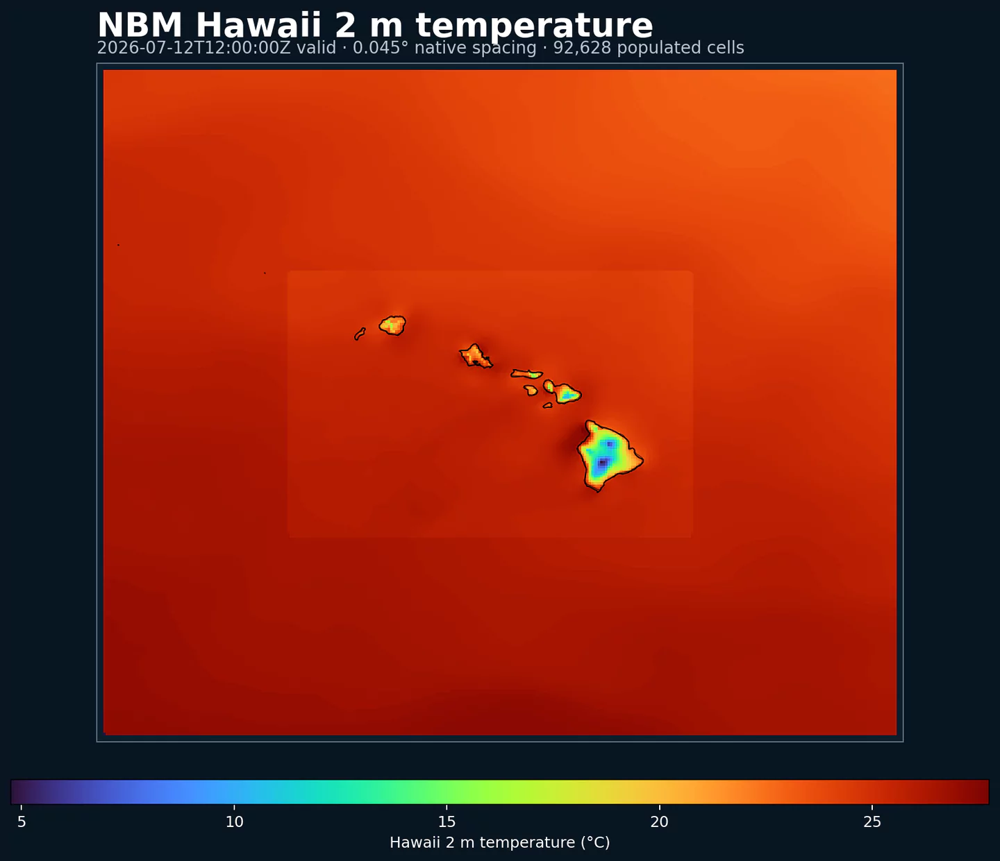
Código GribStream: nbmparhi
Outras grades NBM Parallel:
nbmpar , nbmparak , nbmparpr , nbmpargu , nbmparoc
Status: o NBM v5 já está operacional no GribStream em nbmhi . Em nbmhi, execuções anteriores a 2026-05-05 12:00 UTC contêm a versão operacional anterior do NBM; execuções a partir de 2026-05-05 12:00 UTC usam o NBM v5. Para integrações de produção com NBM v5, use nbmhi; os datasets nbmpar* ficam reservados para futuras iterações experimentais do NBM se a NOAA voltar a publicá-las na linha paralela.
A fonte pública é noaa-nbm-para-pds. O GribStream mantém a linha paralela em códigos dedicados para você compará-la com a família operacional do NBM sem misturá-la ao arquivo usado pelas suas integrações atuais.
Referências técnicas: PNS 25-45 , notas de configuração Winter v5.0 e NBM Versions .
Descrição
NBM Parallel Hawaii é a saída pública paralela do National Blend of Models para Hawaii. Ela serve para comparação e validação quando a NOAA publica uma linha experimental ao lado da versão operacional.
Para produção com NBM v5, o dataset recomendado é nbmhi . nbmparhi fica como referência de comparação e como espaço para futuras iterações experimentais que a NOAA possa publicar na linha paralela.
O NBM v5 não foi apenas uma atualização de parâmetros. A NOAA ampliou grande parte da base horária de previsão de 36 h para 48 h e revisou a mistura com mais Quantile Mapping, mudanças em vento e rajadas determinísticas, e entradas de maior resolução do ECMWF e do Canadá.
Para o Hawaii, a NOAA destacou a orientação horária estendida até 48 h, nova orientação de vento e rajadas a 10 m com Quantile Mapping, e um produto reconstruído de teto de nuvens e visibilidade que segue o enfoque Meld-LAMP com pseudo-observações baseadas em random forest nas ilhas.
No GribStream, nbmparhi mantém seletores estáveis: os valores de name, level e info são copiados exatamente do catálogo e não são traduzidos.
Detalhes
Archive window: Last 5 days
Fonte pública: https://registry.opendata.aws/noaa-nbm-parallel/
Principais características:
Permite comparar a linha pública paralela do NBM com a versão operacional quando a NOAA publica dados paralelos.
Mantém retenção curta, voltada a validação, não a produção nem a arquivo histórico de longo prazo.
Usa os mesmos endpoints do GribStream que a família NBM operacional, com seu próprio código de dataset.
Preserva os códigos de variável, níveis e valores de info do catálogo de nbmparhi.
Resolução: Aproximadamente 2.5 km na grade regional do Hawaii.
Cobertura temporal: Ciclos horários; lead time (horizonte de previsão) de 1 a 264 h quando a fonte publica esses prazos. A linha paralela preserva principalmente os últimos 5 dias.
Principais usos: Comparação da orientação NBM v5 para operações insulares, aviação, turismo, energia, chuva, vento, teto de nuvens, visibilidade e produtos locais antes de usar apenas o dataset operacional.
Datasets relacionados
Parâmetros
Clique em um parâmetro para ver as variantes em uma tabela compacta, com seletores JSON prontos para copiar. Códigos, níveis e valores do seletor ficam exatamente como a API expõe.
APCP
– Accumulated Precipitation (kg/m^2)
2 variants
Accumulated precipitation represents the total water-equivalent amount of rain and snow during the output period. It is a primary field for hydrologic impacts and event totals.
Units: kg/m^2.
Use with the model time interval to interpret totals and compare to gauges.
Level
Info
Horizon
Introduced
Selector
surface
1h-264h
5 days ago
{"name":"APCP","level":"surface","info":""}
Copy
surface
prob >0.254
1h-264h
5 days ago
{"name":"APCP","level":"surface","info":"prob >0.254"}
Copy
APTMP
– Apparent Temperature (K)
1 variant
Apparent temperature combines air temperature, humidity, and wind to estimate how hot or cold it feels to humans. It is useful for heat and cold stress assessments.
Level
Info
Horizon
Introduced
Selector
2 m above ground
1h-264h
5 days ago
{"name":"APTMP","level":"2 m above ground","info":""}
Copy
CAPE
– Convective Available Potential Energy (J/kg)
2 variants
Convective Available Potential Energy (CAPE) quantifies buoyant energy available to rising air parcels. Larger values generally imply stronger potential updrafts and greater convective intensity.
Units: J/kg.
Often used with CIN and lifting mechanisms to assess thunderstorm potential.
Level
Info
Horizon
Introduced
Selector
surface
1h-264h
5 days ago
{"name":"CAPE","level":"surface","info":""}
Copy
surface
ens std dev
1h-264h
5 days ago
{"name":"CAPE","level":"surface","info":"ens std dev"}
Copy
CEIL
– Ceiling Height (m)
7 variants
Ceiling height is the altitude of the lowest cloud base that covers a significant portion of the sky. It is a key aviation and surface-visibility metric.
Level
Info
Horizon
Introduced
Selector
cloud base
1h-84h
5 days ago
{"name":"CEIL","level":"cloud base","info":""}
Copy
cloud ceiling
1h-78h
5 days ago
{"name":"CEIL","level":"cloud ceiling","info":""}
Copy
cloud ceiling
prob <152.4
1h-36h
5 days ago
{"name":"CEIL","level":"cloud ceiling","info":"prob <152.4"}
Copy
cloud ceiling
prob <2011.68
1h-36h
5 days ago
{"name":"CEIL","level":"cloud ceiling","info":"prob <2011.68"}
Copy
cloud ceiling
prob <304.8
1h-36h
5 days ago
{"name":"CEIL","level":"cloud ceiling","info":"prob <304.8"}
Copy
cloud ceiling
prob <609.6
1h-36h
5 days ago
{"name":"CEIL","level":"cloud ceiling","info":"prob <609.6"}
Copy
cloud ceiling
prob <914.5
1h-36h
5 days ago
{"name":"CEIL","level":"cloud ceiling","info":"prob <914.5"}
Copy
DIST
– Distance to Feature (km)
1 variant
Distance to feature is the horizontal distance to the named hazard or boundary in the source product. It is used to map proximity to key features like fronts or hazards.
Level
Info
Horizon
Introduced
Selector
surface - 610 m above ground
1h-36h
5 days ago
{"name":"DIST","level":"surface - 610 m above ground","info":""}
Copy
DPT
– Dew Point Temperature (K)
2 variants
Dew point temperature is the temperature at which the air becomes saturated. It is a direct measure of moisture content.
Units: K.
When dew point is close to air temperature, fog or low cloud potential increases.
Level
Info
Horizon
Introduced
Selector
2 m above ground
1h-264h
5 days ago
{"name":"DPT","level":"2 m above ground","info":""}
Copy
2 m above ground
ens std dev
1h-264h
5 days ago
{"name":"DPT","level":"2 m above ground","info":"ens std dev"}
Copy
DSWRF
– Downward Short-Wave Radiation Flux (W/m^2)
1 variant
Downward radiative flux represents incoming energy at the surface. It is a key driver of surface heating and cooling.
Units: W/m^2.
Shortwave affects surface heating; longwave affects radiative cooling.
Level
Info
Horizon
Introduced
Selector
surface
1h-264h
5 days ago
{"name":"DSWRF","level":"surface","info":""}
Copy
ELLINX
– Ellrod Index (unitless)
1 variant
Ellrod index is a diagnostic for clear-air turbulence based on deformation and vertical wind shear. Higher values indicate greater turbulence potential for aviation.
Level
Info
Horizon
Introduced
Selector
400-300 mb
1h-259h
5 days ago
{"name":"ELLINX","level":"400-300 mb","info":""}
Copy
FOSINDX
– Fosberg Fire Weather Index (unitless)
1 variant
Fosberg fire weather index combines temperature, humidity, and wind to estimate potential fire spread. Higher values indicate more favorable wildfire conditions.
Level
Info
Horizon
Introduced
Selector
surface
6h-264h
5 days ago
{"name":"FOSINDX","level":"surface","info":""}
Copy
GUST
– Wind Speed (Gust) (m/s)
2 variants
Wind gust is the peak short-duration wind speed. It captures brief, hazardous bursts that can exceed sustained winds.
Level
Info
Horizon
Introduced
Selector
10 m above ground
1h-264h
5 days ago
{"name":"GUST","level":"10 m above ground","info":""}
Copy
10 m above ground
ens std dev
1h-264h
5 days ago
{"name":"GUST","level":"10 m above ground","info":"ens std dev"}
Copy
MAXREF
– Hourly Maximum of Simulated Reflectivity at 1 km AGL (dBZ)
1 variant
Hourly maximum simulated reflectivity at 1 km AGL captures the strongest modeled reflectivity near the surface. It is used to identify peak convective intensity and heavy precipitation cores.
Level
Info
Horizon
Introduced
Selector
1000 m above ground
1h-48h
5 days ago
{"name":"MAXREF","level":"1000 m above ground","info":""}
Copy
MAXRH
– Maximum Relative Humidity (percent)
1 variant
Maximum relative humidity is the highest RH reached during the period. It can indicate peak cloud or fog potential.
Units: percent.
Higher values indicate more atmospheric moisture and greater cloud or precip potential.
Level
Info
Horizon
Introduced
Selector
2 m above ground
13h-264h
5 days ago
{"name":"MAXRH","level":"2 m above ground","info":""}
Copy
MINRH
– Minimum Relative Humidity (percent)
1 variant
Minimum relative humidity is the lowest RH reached during the period. It is used in fire‑weather and drying assessments.
Units: percent.
Higher values indicate more atmospheric moisture and greater cloud or precip potential.
Level
Info
Horizon
Introduced
Selector
2 m above ground
13h-264h
5 days ago
{"name":"MINRH","level":"2 m above ground","info":""}
Copy
MIXHT
– Mixing Height (m)
1 variant
Mixing height is the depth of the well-mixed layer near the surface. It is widely used for dispersion, smoke, and air-quality applications.
Level
Info
Horizon
Introduced
Selector
entire atmosphere (considered as a single layer)
1h-264h
5 days ago
{"name":"MIXHT","level":"entire atmosphere (considered as a single layer)","info":""}
Copy
PCPDUR
– Precipitation Duration (hours)
1 variant
Precipitation duration is the total time with measurable precipitation in the output period. It helps distinguish intermittent from persistent events.
Units: hours.
Accumulations represent water-equivalent depth over the output interval; rates describe intensity.
Level
Info
Horizon
Introduced
Selector
surface
12h-36h
5 days ago
{"name":"PCPDUR","level":"surface","info":""}
Copy
PWAT
– Precipitable Water (kg/m^2)
9 variants
Precipitable water is the total column water vapor from the surface to the top of the atmosphere. It is a key moisture indicator.
Level
Info
Horizon
Introduced
Selector
entire atmosphere (considered as a single layer)
1h-264h
5 days ago
{"name":"PWAT","level":"entire atmosphere (considered as a single layer)","info":""}
Copy
entire atmosphere (considered as a single layer)
10% level
1h-264h
5 days ago
{"name":"PWAT","level":"entire atmosphere (considered as a single layer)","info":"10% level"}
Copy
entire atmosphere (considered as a single layer)
50% level
1h-264h
5 days ago
{"name":"PWAT","level":"entire atmosphere (considered as a single layer)","info":"50% level"}
Copy
entire atmosphere (considered as a single layer)
90% level
1h-264h
5 days ago
{"name":"PWAT","level":"entire atmosphere (considered as a single layer)","info":"90% level"}
Copy
entire atmosphere (considered as a single layer)
prob >12.7
1h-264h
5 days ago
{"name":"PWAT","level":"entire atmosphere (considered as a single layer)","info":"prob >12.7"}
Copy
entire atmosphere (considered as a single layer)
prob >25.4
1h-264h
5 days ago
{"name":"PWAT","level":"entire atmosphere (considered as a single layer)","info":"prob >25.4"}
Copy
entire atmosphere (considered as a single layer)
prob >38.1
1h-264h
5 days ago
{"name":"PWAT","level":"entire atmosphere (considered as a single layer)","info":"prob >38.1"}
Copy
entire atmosphere (considered as a single layer)
prob >50.8
1h-264h
5 days ago
{"name":"PWAT","level":"entire atmosphere (considered as a single layer)","info":"prob >50.8"}
Copy
entire atmosphere (considered as a single layer)
prob >63.5
1h-264h
5 days ago
{"name":"PWAT","level":"entire atmosphere (considered as a single layer)","info":"prob >63.5"}
Copy
RETOP
– Radar Echo Top Height (m)
1 variant
Echo top height is the altitude of the highest reflectivity in the column. It is a proxy for storm depth and convective vigor.
Level
Info
Horizon
Introduced
Selector
cloud top
1h-48h
5 days ago
{"name":"RETOP","level":"cloud top","info":""}
Copy
RH
– Relative Humidity (percent)
1 variant
Relative humidity describes how close the air is to saturation at the specified level. High values favor cloud formation.
Units: percent.
Higher values indicate more atmospheric moisture and greater cloud or precip potential.
Level
Info
Horizon
Introduced
Selector
2 m above ground
1h-264h
5 days ago
{"name":"RH","level":"2 m above ground","info":""}
Copy
SNOWLVL
– Snow Level (m)
16 variants
Snow level is the approximate altitude where precipitation changes from rain to snow. It is useful for terrain and road-impact forecasting.
Level
Info
Horizon
Introduced
Selector
0 m above mean sea level
1h-264h
5 days ago
{"name":"SNOWLVL","level":"0 m above mean sea level","info":""}
Copy
surface
1% level
1h-263h
5 days ago
{"name":"SNOWLVL","level":"surface","info":"1% level"}
Copy
surface
10% level
1h-263h
5 days ago
{"name":"SNOWLVL","level":"surface","info":"10% level"}
Copy
surface
20% level
1h-263h
5 days ago
{"name":"SNOWLVL","level":"surface","info":"20% level"}
Copy
surface
25% level
1h-263h
5 days ago
{"name":"SNOWLVL","level":"surface","info":"25% level"}
Copy
surface
30% level
1h-263h
5 days ago
{"name":"SNOWLVL","level":"surface","info":"30% level"}
Copy
surface
40% level
1h-263h
5 days ago
{"name":"SNOWLVL","level":"surface","info":"40% level"}
Copy
surface
5% level
1h-263h
5 days ago
{"name":"SNOWLVL","level":"surface","info":"5% level"}
Copy
surface
50% level
1h-263h
5 days ago
{"name":"SNOWLVL","level":"surface","info":"50% level"}
Copy
surface
60% level
1h-263h
5 days ago
{"name":"SNOWLVL","level":"surface","info":"60% level"}
Copy
surface
70% level
1h-263h
5 days ago
{"name":"SNOWLVL","level":"surface","info":"70% level"}
Copy
surface
75% level
1h-263h
5 days ago
{"name":"SNOWLVL","level":"surface","info":"75% level"}
Copy
surface
80% level
1h-263h
5 days ago
{"name":"SNOWLVL","level":"surface","info":"80% level"}
Copy
surface
90% level
1h-263h
5 days ago
{"name":"SNOWLVL","level":"surface","info":"90% level"}
Copy
surface
95% level
1h-263h
5 days ago
{"name":"SNOWLVL","level":"surface","info":"95% level"}
Copy
surface
99% level
1h-263h
5 days ago
{"name":"SNOWLVL","level":"surface","info":"99% level"}
Copy
TCDC
– Total Cloud Cover (percent)
3 variants
Total cloud cover is the fraction of the grid cell covered by clouds at any level. It influences radiation, temperature, and visibility.
Units: percent.
Cloud fraction influences surface radiation and temperature.
Level
Info
Horizon
Introduced
Selector
surface
1h-264h
5 days ago
{"name":"TCDC","level":"surface","info":""}
Copy
surface
ens std dev
1h-48h
5 days ago
{"name":"TCDC","level":"surface","info":"ens std dev"}
Copy
surface
unknown derived fcst
49h-264h
5 days ago
{"name":"TCDC","level":"surface","info":"unknown derived fcst"}
Copy
THUNC
– Thunderstorm Probability (percent)
1 variant
Thunderstorm probability gives the chance of thunderstorms during the valid period. It is used for convective hazard guidance.
Level
Info
Horizon
Introduced
Selector
entire atmosphere
1h-36h
5 days ago
{"name":"THUNC","level":"entire atmosphere","info":""}
Copy
TMAX
– Maximum Temperature (K)
2 variants
Maximum temperature is the highest temperature reached during the output period. It is commonly used for heat stress and daily extremes.
Level
Info
Horizon
Introduced
Selector
2 m above ground
12h-264h
5 days ago
{"name":"TMAX","level":"2 m above ground","info":""}
Copy
2 m above ground
ens std dev
12h-264h
5 days ago
{"name":"TMAX","level":"2 m above ground","info":"ens std dev"}
Copy
TMIN
– Minimum Temperature (K)
2 variants
Minimum temperature is the lowest temperature reached during the output period. It is commonly used for frost and cold-stress assessment.
Level
Info
Horizon
Introduced
Selector
2 m above ground
12h-264h
5 days ago
{"name":"TMIN","level":"2 m above ground","info":""}
Copy
2 m above ground
ens std dev
12h-264h
5 days ago
{"name":"TMIN","level":"2 m above ground","info":"ens std dev"}
Copy
TMP
– Temperature (K)
2 variants
Air temperature is the thermal state of the atmosphere at the specified level. It influences density, stability, and energy exchange.
Level
Info
Horizon
Introduced
Selector
2 m above ground
1h-264h
5 days ago
{"name":"TMP","level":"2 m above ground","info":""}
Copy
2 m above ground
ens std dev
1h-264h
5 days ago
{"name":"TMP","level":"2 m above ground","info":"ens std dev"}
Copy
TPWDIR
– Total Precipitable Water Transport Direction (degrees)
1 variant
Total precipitable water transport direction is the direction of column‑integrated moisture flux. It indicates moisture transport pathways.
Level
Info
Horizon
Introduced
Selector
10 m above ground
1h-167h
5 days ago
{"name":"TPWDIR","level":"10 m above ground","info":""}
Copy
TPWSPD
– Total Precipitable Water Transport Speed (m/s)
1 variant
Total precipitable water transport speed is the magnitude of column‑integrated moisture transport. It highlights atmospheric river strength.
Level
Info
Horizon
Introduced
Selector
10 m above ground
1h-167h
5 days ago
{"name":"TPWSPD","level":"10 m above ground","info":""}
Copy
TRWDIR
– Tropical Wind Direction (degrees)
1 variant
Tropical wind direction is the direction of the tropical wind vector used in cyclone guidance.
Level
Info
Horizon
Introduced
Selector
entire atmosphere (considered as a single layer)
1h-264h
5 days ago
{"name":"TRWDIR","level":"entire atmosphere (considered as a single layer)","info":""}
Copy
TRWSPD
– Tropical Wind Speed (m/s)
1 variant
Tropical wind speed is the magnitude of the tropical wind vector. It is often used in cyclone diagnostics.
Level
Info
Horizon
Introduced
Selector
entire atmosphere (considered as a single layer)
1h-264h
5 days ago
{"name":"TRWSPD","level":"entire atmosphere (considered as a single layer)","info":""}
Copy
TSTM
– Thunderstorm Indicator (boolean)
1 variant
Thunderstorm indicator flags the presence of thunderstorm conditions in the grid cell. It is used as a categorical hazard field.
Level
Info
Horizon
Introduced
Selector
surface
probability forecast
1h-192h
5 days ago
{"name":"TSTM","level":"surface","info":"probability forecast"}
Copy
TURB
– Turbulence Index (unitless)
1 variant
Turbulence index is a diagnostic measure of aviation turbulence. Higher values indicate increased turbulence risk along flight routes.
Level
Info
Horizon
Introduced
Selector
surface - 1372 m above ground
1h-259h
5 days ago
{"name":"TURB","level":"surface - 1372 m above ground","info":""}
Copy
VIL
– Vertically-Integrated Liquid Water (kg/m^2)
1 variant
Vertically‑integrated liquid water is the total column liquid water content. It is used as a proxy for precipitation intensity and hail potential.
Level
Info
Horizon
Introduced
Selector
entire atmosphere
1h-48h
5 days ago
{"name":"VIL","level":"entire atmosphere","info":""}
Copy
VIS
– Visibility (m)
5 variants
Horizontal visibility at the surface. Lower values indicate reduced visibility due to fog, precipitation, or aerosols.
Level
Info
Horizon
Introduced
Selector
surface
1h-79h
5 days ago
{"name":"VIS","level":"surface","info":""}
Copy
surface
prob <1609.34
1h-36h
5 days ago
{"name":"VIS","level":"surface","info":"prob <1609.34"}
Copy
surface
prob <3218.69
1h-36h
5 days ago
{"name":"VIS","level":"surface","info":"prob <3218.69"}
Copy
surface
prob <4828.03
1h-36h
5 days ago
{"name":"VIS","level":"surface","info":"prob <4828.03"}
Copy
surface
prob <8046.73
1h-36h
5 days ago
{"name":"VIS","level":"surface","info":"prob <8046.73"}
Copy
VRATE
– Ventilation Rate (m^2/s)
1 variant
Ventilation rate combines mixing depth and transport wind to estimate the atmosphere's ability to disperse smoke and pollutants.
Level
Info
Horizon
Introduced
Selector
entire atmosphere (considered as a single layer)
1h-264h
5 days ago
{"name":"VRATE","level":"entire atmosphere (considered as a single layer)","info":""}
Copy
WDIR
– Wind Direction (degrees)
4 variants
Wind direction indicates the direction from which the wind is blowing at the specified level.
Level
Info
Horizon
Introduced
Selector
10 m above ground
1h-264h
5 days ago
{"name":"WDIR","level":"10 m above ground","info":""}
Copy
30 m above ground
1h-264h
5 days ago
{"name":"WDIR","level":"30 m above ground","info":""}
Copy
80 m above ground
1h-264h
5 days ago
{"name":"WDIR","level":"80 m above ground","info":""}
Copy
surface - 610 m above ground
1h-36h
5 days ago
{"name":"WDIR","level":"surface - 610 m above ground","info":""}
Copy
WETGLBT
– Wet Bulb Globe Temperature (K)
1 variant
Wet bulb globe temperature combines temperature, humidity, radiation, and wind effects into a single heat-stress metric. It is commonly used for outdoor exposure and occupational heat-risk assessment.
Units: K.
Use it as a composite heat-stress indicator rather than a standard air-temperature field.
Level
Info
Horizon
Introduced
Selector
surface
1h-264h
5 days ago
{"name":"WETGLBT","level":"surface","info":""}
Copy
WIND
– Wind Speed (m/s)
5 variants
Wind speed is the magnitude of the horizontal wind at the specified level. It is used for transport, mixing, and hazards.
Level
Info
Horizon
Introduced
Selector
10 m above ground
1h-264h
5 days ago
{"name":"WIND","level":"10 m above ground","info":""}
Copy
10 m above ground
ens std dev
1h-264h
5 days ago
{"name":"WIND","level":"10 m above ground","info":"ens std dev"}
Copy
30 m above ground
1h-264h
5 days ago
{"name":"WIND","level":"30 m above ground","info":""}
Copy
80 m above ground
1h-264h
5 days ago
{"name":"WIND","level":"80 m above ground","info":""}
Copy
surface - 610 m above ground
1h-36h
5 days ago
{"name":"WIND","level":"surface - 610 m above ground","info":""}
Copy
Nenhum parâmetro corresponde à busca.