
GribStream Blog
GOES-19 ABI satellite rainfall rate now available on GribStream
Query NOAA GOES-East full-disk rainfall-rate estimates at about 2 km resolution at nadir and approximately 10-minute intervals.
Update (July 19, 2026): RRQPE is now included in the broader 2 km goes19abi dataset. New integrations should use goes19abi; the original goes19rrqpef endpoint remains readable as a compatibility alias for existing requests.
GribStream now provides the NOAA GOES-19 Advanced Baseline Imager full-disk rainfall-rate product as dataset goes19rrqpef.
This is an observation-derived estimate of instantaneous rainfall rate, not a forecast or an accumulation. It covers most of the Americas and large adjacent ocean areas on the native GOES-East geostationary grid, with new full-disk scans nominally every 10 minutes.
This is the first canary release of GOES data on GribStream. We plan to add many more ABI and related GOES datasets soon, using this initial product to validate the experience before expanding the catalog.
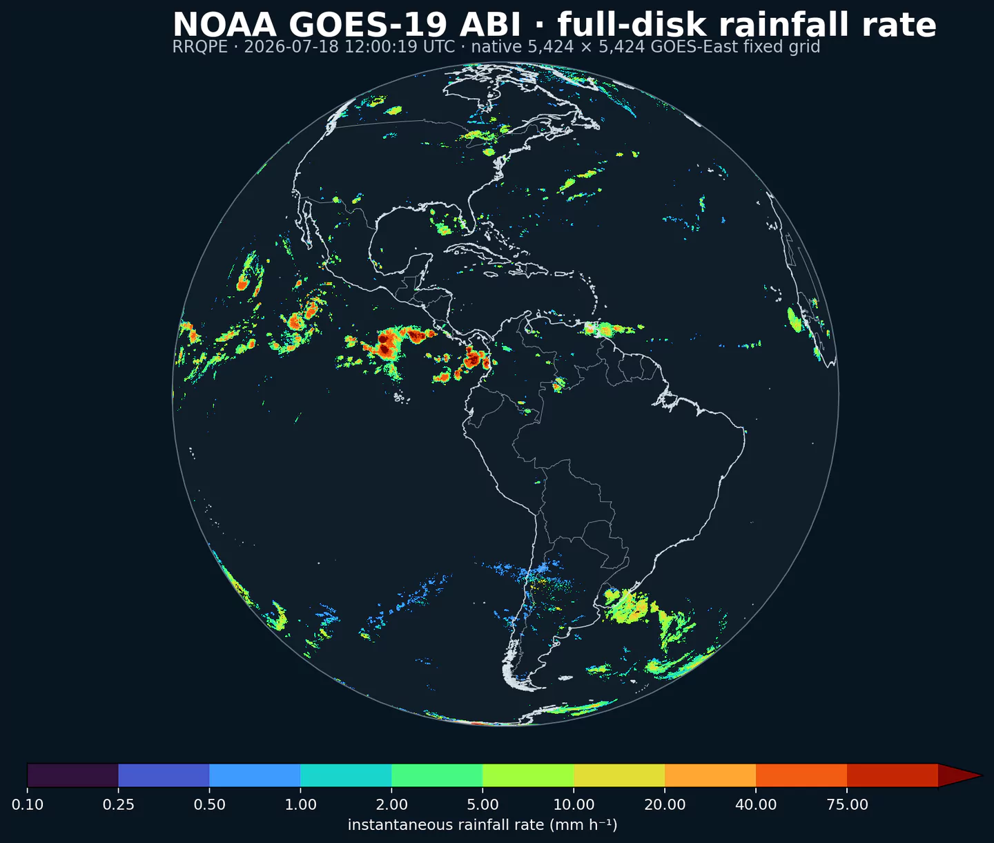
RRQPE at 2026-07-18 12:00:19 UTC, rendered from the native 5,424 by 5,424 GOES-East fixed grid. Colors show instantaneous rainfall rate in mm h-1.What ABI and RRQPE mean
ABI is the Advanced Baseline Imager aboard NOAA's GOES-R-series geostationary satellites. Its 16 spectral bands continuously observe the same broad Earth disk. The Level 2 Rainfall Rate Quantitative Precipitation Estimate, abbreviated RRQPE, combines cloud-top infrared observations with microwave rainfall calibration to estimate instantaneous precipitation.
That broad view is especially useful over oceans, islands, mountains, and radar-sparse regions. It also supplies a consistent observation layer for tropical systems and storms that cross national radar-network boundaries.
What is available
| Property | GribStream value |
|---|---|
| Dataset | goes19rrqpef |
| Parameter | RRQPE at surface |
| Unit | mm h-1 |
| Grid | Native 5,424 by 5,424 GOES-East fixed grid |
| Spatial sampling | About 2 km at nadir; coarser toward the limb |
| Observation interval | Approximately 10 minutes |
| GribStream history | April 8, 2025 onward |
| Forecast lead | 0h; this is an observation-derived analysis |
GribStream preserves the source scan time to the second. Cells outside the visible Earth disk and source fill values are returned as null.
Why the history starts on April 8, 2025
GOES-19 was checked out near 89.5 degrees west before NOAA drifted it to the operational GOES-East slot near 75.2 degrees west. NOAA declared the satellite operational on April 7, 2025. ABI products in that slot use the nominal fixed grid centered at 75 degrees west.
GribStream coverage begins on the next UTC day, the first full day after operational commissioning. This keeps the available record on the stable GOES-East geometry used by the product today. The earlier relocation was a one-time commissioning transition, not a routinely recurring projection change.
Explore the rainfall-rate inventory
The broader GOES-19 ABI 2 km inventory lists RRQPE alongside the other available satellite fields, units, and coverage periods. The original rainfall-rate inventory remains available for the compatibility alias.
Interpretation and availability limits
RRQPE is a satellite-derived estimate, not a direct rain-gauge or weather-radar measurement. Cloud properties, viewing angle, algorithm assumptions, and microwave calibration can affect accuracy. Ground footprint and retrieval quality generally degrade toward the edge of the visible disk. For important decisions, compare it with local observations and available quality information.
New scans depend on NOAA's satellite feed. Maneuvers, calibration, outages, and product transitions can create gaps or temporarily pause updates. A future change of satellite or grid may therefore mark a new coverage period rather than extend this record seamlessly.
Authoritative sources and related datasets:
- NOAA/NESDIS geostationary satellites: https://www.nesdis.noaa.gov/our-satellites/currently-flying/geostationary-satellites
- NOAA RRQPE product metadata: https://www.ncei.noaa.gov/access/metadata/landing-page/bin/iso?id=gov.noaa.ncdc%3AC01517
- NOAA GOES open-data registry: https://registry.opendata.aws/noaa-goes/
- NOAA ABI overview: https://goes-r.noaa.gov/spacesegment/abi.html
- MRMS radar and multi-sensor precipitation analyses
- RTMA hourly surface analyses
- HRRR convection-resolving forecasts