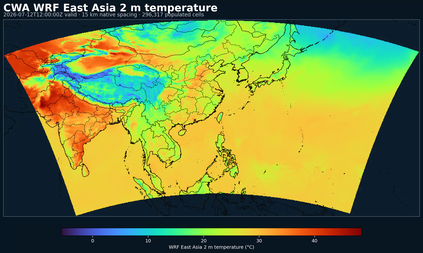
GribStream-Code: cwawrf15
Referenzen: technisches Dokument zu CWA WRF 15 km , CWA Open Data auf AWS und Taiwan Open Government Data License .
Beschreibung
CWA WRF 15 km ist eine regionale numerische Vorhersage der taiwanischen Central Weather Administration. Sie ergänzt globale Modelle, wenn eine Anwendung regionalen Kontext für Ostasien oder den westlichen Pazifik braucht.
Die Domain reicht von den Tropen nordwärts über Taiwan, das Südchinesische Meer, die Philippinensee, Gewässer nahe Japan und regionale Wetterkorridore, die häufig von Taifunen beeinflusst werden.
Das Modell nutzt Weather Research and Forecasting (WRF), ein mesoskaliges numerisches Wettervorhersagesystem für operative Vorhersage und atmosphärische Forschung. CWA veröffentlicht diese regionale 15-km-Konfiguration neben einem höher aufgelösten WRF-Produkt mit Fokus auf Taiwan; die 15-km-Domain ist die breitere Variante, mit 661 mal 385 Gridpunkten und Vorhersagen bis 84 h.
Das Dataset enthält Drucklevel- und oberflächennahe Felder wie Wind, Temperatur, Feuchte, Höhe, Druck, Niederschlag, Strahlung und Oberflächendiagnostik. Diese Mischung ist nützlich, wenn Druckgradienten, Steering Flow (steuernde Strömung), Feuchtestruktur und Niederschlagsentwicklung wichtig sind.
In GribStream ist cwawrf15 sinnvoll, wenn Ihr Workflow auf Ostasien oder den westlichen Pazifik ausgerichtet ist und regionale Modellinformation neben globaler Vorhersagebasis von ECMWF IFS , GFS oder AIGFS Surface benötigt.
Details
Archive window: Last 3 days
Öffentliche Quelle: https://data.gov.tw/en/datasets/58977
Wichtigste Merkmale:
Regionales WRF-Modell der taiwanischen Central Weather Administration für Ostasien und den westlichen Pazifik.
Breite Domain mit Taiwan, Südchinesischem Meer, Philippinensee, Gewässern nahe Japan und regionalen Wetterkorridoren.
Lambert-konformes Grid mit 661 mal 385 Punkten und 15-km-Auflösung.
Felder für Wind, Temperatur, Feuchte, Höhe, Druck, Niederschlag, Strahlung und Skin Temperature.
Auflösung: 15-km-Lambert-Grid für Ostasien und den westlichen Pazifik, 661 mal 385 Punkte.
Zeitliche Abdeckung: Läufe um 00, 06, 12 und 18 UTC, mit 6-h-Schritten bis 84 h.
Hauptanwendungen: Schiffsrouten, regionale Luftfahrt, Logistik, Energie, Monitoring von Taifunregionen und Anwendungen, die regionalen Kontext neben globaler Vorhersagebasis benötigen.
Verwandte Datasets
Parameter
Klicken Sie auf einen Parameter, um Varianten in einer kompakten Tabelle mit kopierbaren JSON-Selektoren zu sehen. Codes, Levels und Selector-Werte bleiben exakt so, wie die API sie ausgibt.
APCP
– Accumulated Precipitation (kg/m^2)
1 variant
Accumulated precipitation represents the total water-equivalent amount of rain and snow during the output period. It is a primary field for hydrologic impacts and event totals.
Units: kg/m^2.
Use with the model time interval to interpret totals and compare to gauges.
Level
Info
Horizon
Introduced
Selector
surface
0h-84h
3 days ago
{"name":"APCP","level":"surface","info":""}
Copy
DPT
– Dew Point Temperature (K)
1 variant
Dew point temperature is the temperature at which the air becomes saturated. It is a direct measure of moisture content.
Units: K.
When dew point is close to air temperature, fog or low cloud potential increases.
Level
Info
Horizon
Introduced
Selector
2 m above ground
0h-84h
3 days ago
{"name":"DPT","level":"2 m above ground","info":""}
Copy
DZDT
– Vertical Velocity (Geometric) (m/s)
11 variants
Geometric vertical velocity (dz/dt) is the vertical speed of air in height coordinates. Positive values indicate rising motion and negative values sinking motion.
Level
Info
Horizon
Introduced
Selector
100 mb
0h-84h
3 days ago
{"name":"DZDT","level":"100 mb","info":""}
Copy
1000 mb
0h-84h
3 days ago
{"name":"DZDT","level":"1000 mb","info":""}
Copy
150 mb
0h-84h
3 days ago
{"name":"DZDT","level":"150 mb","info":""}
Copy
200 mb
0h-84h
3 days ago
{"name":"DZDT","level":"200 mb","info":""}
Copy
250 mb
0h-84h
3 days ago
{"name":"DZDT","level":"250 mb","info":""}
Copy
300 mb
0h-84h
3 days ago
{"name":"DZDT","level":"300 mb","info":""}
Copy
400 mb
0h-84h
3 days ago
{"name":"DZDT","level":"400 mb","info":""}
Copy
500 mb
0h-84h
3 days ago
{"name":"DZDT","level":"500 mb","info":""}
Copy
700 mb
0h-84h
3 days ago
{"name":"DZDT","level":"700 mb","info":""}
Copy
850 mb
0h-84h
3 days ago
{"name":"DZDT","level":"850 mb","info":""}
Copy
925 mb
0h-84h
3 days ago
{"name":"DZDT","level":"925 mb","info":""}
Copy
HGT
– Geopotential Height (gpm)
11 variants
Geopotential height is the altitude of a pressure surface in the atmosphere. It is the primary field for identifying ridges, troughs, and large‑scale flow patterns.
Level
Info
Horizon
Introduced
Selector
100 mb
0h-84h
3 days ago
{"name":"HGT","level":"100 mb","info":""}
Copy
1000 mb
0h-84h
3 days ago
{"name":"HGT","level":"1000 mb","info":""}
Copy
150 mb
0h-84h
3 days ago
{"name":"HGT","level":"150 mb","info":""}
Copy
200 mb
0h-84h
3 days ago
{"name":"HGT","level":"200 mb","info":""}
Copy
250 mb
0h-84h
3 days ago
{"name":"HGT","level":"250 mb","info":""}
Copy
300 mb
0h-84h
3 days ago
{"name":"HGT","level":"300 mb","info":""}
Copy
400 mb
0h-84h
3 days ago
{"name":"HGT","level":"400 mb","info":""}
Copy
500 mb
0h-84h
3 days ago
{"name":"HGT","level":"500 mb","info":""}
Copy
700 mb
0h-84h
3 days ago
{"name":"HGT","level":"700 mb","info":""}
Copy
850 mb
0h-84h
3 days ago
{"name":"HGT","level":"850 mb","info":""}
Copy
925 mb
0h-84h
3 days ago
{"name":"HGT","level":"925 mb","info":""}
Copy
NSWRF
– Net short-wave radiation flux (W/m^2)
1 variant
Net short-wave radiation flux (W/m^2).
Level
Info
Horizon
Introduced
Selector
surface
0h-84h
3 days ago
{"name":"NSWRF","level":"surface","info":""}
Copy
PRES
– Pressure (Pa)
1 variant
Pressure is the atmospheric pressure at the specified level. It is a fundamental mass-field variable for dynamics and thermodynamics.
Level
Info
Horizon
Introduced
Selector
surface
0h-84h
3 days ago
{"name":"PRES","level":"surface","info":""}
Copy
PRMSL
– Pressure Reduced to Mean Sea Level (Pa)
1 variant
Pressure reduced to mean sea level is MSLP computed from surface pressure and temperature. It is used to locate highs and lows.
Level
Info
Horizon
Introduced
Selector
mean sea level
0h-84h
3 days ago
{"name":"PRMSL","level":"mean sea level","info":""}
Copy
RH
– Relative Humidity (percent)
12 variants
Relative humidity describes how close the air is to saturation at the specified level. High values favor cloud formation.
Units: percent.
Higher values indicate more atmospheric moisture and greater cloud or precip potential.
Level
Info
Horizon
Introduced
Selector
100 mb
0h-84h
3 days ago
{"name":"RH","level":"100 mb","info":""}
Copy
1000 mb
0h-84h
3 days ago
{"name":"RH","level":"1000 mb","info":""}
Copy
150 mb
0h-84h
3 days ago
{"name":"RH","level":"150 mb","info":""}
Copy
2 m above ground
0h-84h
3 days ago
{"name":"RH","level":"2 m above ground","info":""}
Copy
200 mb
0h-84h
3 days ago
{"name":"RH","level":"200 mb","info":""}
Copy
250 mb
0h-84h
3 days ago
{"name":"RH","level":"250 mb","info":""}
Copy
300 mb
0h-84h
3 days ago
{"name":"RH","level":"300 mb","info":""}
Copy
400 mb
0h-84h
3 days ago
{"name":"RH","level":"400 mb","info":""}
Copy
500 mb
0h-84h
3 days ago
{"name":"RH","level":"500 mb","info":""}
Copy
700 mb
0h-84h
3 days ago
{"name":"RH","level":"700 mb","info":""}
Copy
850 mb
0h-84h
3 days ago
{"name":"RH","level":"850 mb","info":""}
Copy
925 mb
0h-84h
3 days ago
{"name":"RH","level":"925 mb","info":""}
Copy
SKINT
– Skin temperature (K)
1 variant
Skin temperature (K).
Level
Info
Horizon
Introduced
Selector
surface
0h-84h
3 days ago
{"name":"SKINT","level":"surface","info":""}
Copy
SPFH
– Specific Humidity (kg/kg)
1 variant
Specific humidity is the mass of water vapor per mass of air at the specified level. It is central to moisture transport.
Units: kg/kg.
Higher values indicate more atmospheric moisture and greater cloud or precip potential.
Level
Info
Horizon
Introduced
Selector
2 m above ground
0h-84h
3 days ago
{"name":"SPFH","level":"2 m above ground","info":""}
Copy
TMP
– Temperature (K)
13 variants
Air temperature is the thermal state of the atmosphere at the specified level. It influences density, stability, and energy exchange.
Level
Info
Horizon
Introduced
Selector
100 mb
0h-84h
3 days ago
{"name":"TMP","level":"100 mb","info":""}
Copy
1000 mb
0h-84h
3 days ago
{"name":"TMP","level":"1000 mb","info":""}
Copy
150 mb
0h-84h
3 days ago
{"name":"TMP","level":"150 mb","info":""}
Copy
2 m above ground
0h-84h
3 days ago
{"name":"TMP","level":"2 m above ground","info":""}
Copy
200 mb
0h-84h
3 days ago
{"name":"TMP","level":"200 mb","info":""}
Copy
250 mb
0h-84h
3 days ago
{"name":"TMP","level":"250 mb","info":""}
Copy
300 mb
0h-84h
3 days ago
{"name":"TMP","level":"300 mb","info":""}
Copy
400 mb
0h-84h
3 days ago
{"name":"TMP","level":"400 mb","info":""}
Copy
500 mb
0h-84h
3 days ago
{"name":"TMP","level":"500 mb","info":""}
Copy
700 mb
0h-84h
3 days ago
{"name":"TMP","level":"700 mb","info":""}
Copy
850 mb
0h-84h
3 days ago
{"name":"TMP","level":"850 mb","info":""}
Copy
925 mb
0h-84h
3 days ago
{"name":"TMP","level":"925 mb","info":""}
Copy
mean sea level
0h-84h
3 days ago
{"name":"TMP","level":"mean sea level","info":""}
Copy
UGRD
– U-Component of Wind (m/s)
12 variants
U‑component of wind is the east‑west component of the horizontal wind. Combine with v for speed and direction.
Units: m/s.
Combine u and v components to compute speed and direction.
Level
Info
Horizon
Introduced
Selector
10 m above ground
0h-84h
3 days ago
{"name":"UGRD","level":"10 m above ground","info":""}
Copy
100 mb
0h-84h
3 days ago
{"name":"UGRD","level":"100 mb","info":""}
Copy
1000 mb
0h-84h
3 days ago
{"name":"UGRD","level":"1000 mb","info":""}
Copy
150 mb
0h-84h
3 days ago
{"name":"UGRD","level":"150 mb","info":""}
Copy
200 mb
0h-84h
3 days ago
{"name":"UGRD","level":"200 mb","info":""}
Copy
250 mb
0h-84h
3 days ago
{"name":"UGRD","level":"250 mb","info":""}
Copy
300 mb
0h-84h
3 days ago
{"name":"UGRD","level":"300 mb","info":""}
Copy
400 mb
0h-84h
3 days ago
{"name":"UGRD","level":"400 mb","info":""}
Copy
500 mb
0h-84h
3 days ago
{"name":"UGRD","level":"500 mb","info":""}
Copy
700 mb
0h-84h
3 days ago
{"name":"UGRD","level":"700 mb","info":""}
Copy
850 mb
0h-84h
3 days ago
{"name":"UGRD","level":"850 mb","info":""}
Copy
925 mb
0h-84h
3 days ago
{"name":"UGRD","level":"925 mb","info":""}
Copy
VGRD
– V-Component of Wind (m/s)
12 variants
V‑component of wind is the north‑south component of the horizontal wind. Combine with u for speed and direction.
Units: m/s.
Combine u and v components to compute speed and direction.
Level
Info
Horizon
Introduced
Selector
10 m above ground
0h-84h
3 days ago
{"name":"VGRD","level":"10 m above ground","info":""}
Copy
100 mb
0h-84h
3 days ago
{"name":"VGRD","level":"100 mb","info":""}
Copy
1000 mb
0h-84h
3 days ago
{"name":"VGRD","level":"1000 mb","info":""}
Copy
150 mb
0h-84h
3 days ago
{"name":"VGRD","level":"150 mb","info":""}
Copy
200 mb
0h-84h
3 days ago
{"name":"VGRD","level":"200 mb","info":""}
Copy
250 mb
0h-84h
3 days ago
{"name":"VGRD","level":"250 mb","info":""}
Copy
300 mb
0h-84h
3 days ago
{"name":"VGRD","level":"300 mb","info":""}
Copy
400 mb
0h-84h
3 days ago
{"name":"VGRD","level":"400 mb","info":""}
Copy
500 mb
0h-84h
3 days ago
{"name":"VGRD","level":"500 mb","info":""}
Copy
700 mb
0h-84h
3 days ago
{"name":"VGRD","level":"700 mb","info":""}
Copy
850 mb
0h-84h
3 days ago
{"name":"VGRD","level":"850 mb","info":""}
Copy
925 mb
0h-84h
3 days ago
{"name":"VGRD","level":"925 mb","info":""}
Copy
Keine Parameter passen zur Suche.