Aerosol optical thickness (dimensionless).

GribStream
GribStream Code: refs2dfld
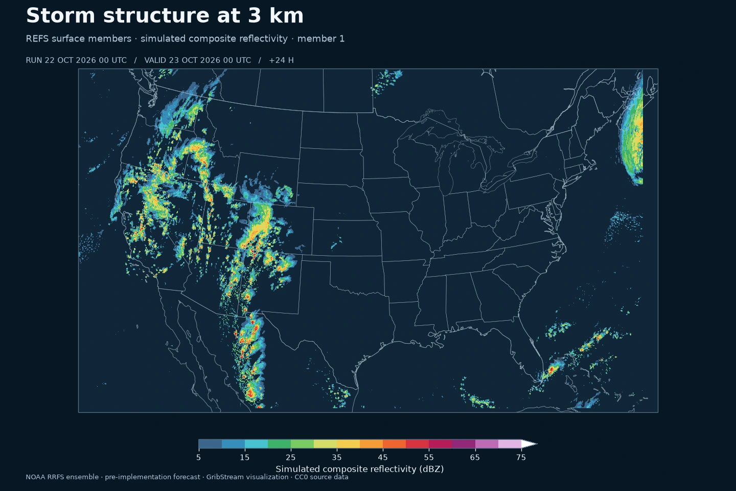
NOAA RRFS ensemble forecasts on a 3 km CONUS grid: five members, hourly through 60 hours, covering near-surface weather, precipitation and storm diagnostics. Available from the pre-implementation feed.
| Dataset | refs2dfld |
|---|---|
| Grid | CONUS · 3 km · 1799 × 1059 |
| Members | 1, 2, 3, 4, 5 |
| New runs (UTC) | 00 / 06 / 12 / 18 UTC |
| Forecast leads | +0…60 h · Δt = 1 h |
| Current parameters | 41 |
Compare the timing of wind ramps and rainfall, explore cloud and solar scenarios, and evaluate storm-related thresholds for individual locations. Keep the five member series to see how the scenarios diverge.
NOAA’s Rapid Refresh Forecast System version 1 uses the limited-area Finite-Volume Cubed-Sphere (FV3) dynamical core within the Unified Forecast System. Its North American domain has 3 km horizontal grid spacing; these datasets expose the CONUS output on a 1,799 × 1,059 Lambert conformal grid. The system targets short-range severe convection, heavy precipitation, winter weather and other hazards for which the timing and structure of weather systems matter. RRFSv1 complements HRRR, which remains in operation. NOAA GSL: RRFSv1; NCEP: RRFS products.
The five current-cycle members vary initial conditions, lateral boundary conditions and model physics relative to the deterministic RRFS forecast. Initial conditions represent uncertainty in the starting atmosphere; boundary conditions affect weather entering the regional domain; physics choices change the treatment of processes such as clouds and turbulence. Following the same member across fields preserves its evolving weather scenario. NWS SCN 26-48.
GribStream’s REFS member datasets contain the five individual RRFS ensemble forecasts from one initialization. NOAA’s RRFS Ensemble Forecast System (REFS) statistics combine current and six-hour-old RRFS deterministic and ensemble runs, with current and older HRRR runs over CONUS and Alaska. An average or threshold count across these five members therefore has a different membership from NOAA’s published REFS mean or probability products. NWS SCN 26-48.
A 3 km grid can represent mesoscale structure, but grid spacing is not a guarantee of storm-location accuracy or a promise to resolve individual tornadoes. Clouds, turbulence and other unresolved processes still require parameterization; RRFSv1 also uses convective parameterization. Do not equate “convection-allowing” with “all convection explicitly resolved.” The physics and evaluation context are documented by NOAA: RRFSv1 physics development and NCEP/EMC evaluation.
With five members, an unweighted threshold count changes in steps of 20 percentage points. That arithmetic is a sample frequency, not a calibrated event probability. Shared model errors can remain even when all five agree. For site decisions, examine nearby cells, adjacent forecast hours and successive runs, and verify against observations. This archive spans a changing pre-implementation system, so it is not a stationary climatology or a skill ranking against HRRR, HREF or a global ensemble.
The 2D product combines near-surface weather with column and storm diagnostics. Simulated composite reflectivity describes the model’s radar-like precipitation structure; it is not a radar observation. CAPE and inhibition describe the modeled convective environment, while updraft helicity is a rotating-updraft diagnostic, not a tornado probability. Rainfall and wind maxima need their published time windows when assessing impacts. The complete field, level, unit and statistic inventory is in the table below.
Instantaneous fields describe one forecast time. Hourly averages and extrema describe an interval. For precipitation, acc-1h is the preceding-hour amount and acc-from-init is the total since the run began. At +1h those two intervals coincide. Temperature is in kelvin, wind in m/s, precipitation in kg/m² (equivalent to mm of water), and snowfall depth in metres.
The new CONUS archive begins with the 9 September 2026 12 UTC run. Historical surface files also include FRZR freezing-rain accumulation, giving 42 parameter names across the archive versus 41 in the current product. NOAA's October 15 revision removed that accumulation and changed instantaneous precipitation-type processing. Compare precipitation-type verification across that change with care. The pressure product contains eight parameters throughout the reviewed archive.
Members 1–5 are individual forecasts. The deterministic RRFS datasets remain separate. NOAA's ensemble means, spread and probability products are a later addition, as are Alaska, Hawaii and Puerto Rico. The refsprslev name now refers to this CONUS product; the retired prototype's North America grid and history are not carried forward.
Companion member dataset: refsprslev · Deterministic RRFS 2D · Deterministic RRFS 3D
These are NOAA's pre-implementation member forecasts. NWS schedules operational implementation for 3 November 2026, subject to weather-related delay. NOAA provides the data under CC0 and requests attribution. GribStream preserves the published values and member identities.
NOAA / AWS · NWS SCN 26-48 · CC0-1.0
Click a parameter to reveal variants in a compact table with ready-to-copy JSON selectors.
Aerosol optical thickness (dimensionless).
| Level | Info | Horizon | Introduced | Selector |
|---|---|---|---|---|
entire atmosphere (considered as a single layer) |
0h-60h | 2026-09-09 |
{"name":"AOTK","level":"entire atmosphere (considered as a single layer)","info":""}
|
Total Precipitation (kg/m2).
| Level | Info | Horizon | Introduced | Selector |
|---|---|---|---|---|
surface |
acc-1h |
1h-60h | 2026-09-09 |
{"name":"APCP","level":"surface","info":"acc-1h"}
|
surface |
acc-from-init |
1h-60h | 2026-09-09 |
{"name":"APCP","level":"surface","info":"acc-from-init"}
|
Accumulated snowfall depth (m).
| Level | Info | Horizon | Introduced | Selector |
|---|---|---|---|---|
surface |
acc-from-init |
1h-60h | 2026-09-09 |
{"name":"ASNOW","level":"surface","info":"acc-from-init"}
|
Convective available potential energy (J/kg).
| Level | Info | Horizon | Introduced | Selector |
|---|---|---|---|---|
surface |
0h-60h | 2026-09-09 |
{"name":"CAPE","level":"surface","info":""}
|
Ceiling (m).
| Level | Info | Horizon | Introduced | Selector |
|---|---|---|---|---|
cloud ceiling |
0h-60h | 2026-09-09 |
{"name":"CEIL","level":"cloud ceiling","info":""}
|
Categorical freezing rain (code).
| Level | Info | Horizon | Introduced | Selector |
|---|---|---|---|---|
surface |
0h-60h | 2026-09-09 |
{"name":"CFRZR","level":"surface","info":""}
|
Categorical ice pellets (code).
| Level | Info | Horizon | Introduced | Selector |
|---|---|---|---|---|
surface |
0h-60h | 2026-09-09 |
{"name":"CICEP","level":"surface","info":""}
|
Convective inhibition (J/kg).
| Level | Info | Horizon | Introduced | Selector |
|---|---|---|---|---|
surface |
0h-60h | 2026-09-09 |
{"name":"CIN","level":"surface","info":""}
|
Percent frozen precipitation (%).
| Level | Info | Horizon | Introduced | Selector |
|---|---|---|---|---|
surface |
0h-60h | 2026-09-09 |
{"name":"CPOFP","level":"surface","info":""}
|
Categorical rain (code).
| Level | Info | Horizon | Introduced | Selector |
|---|---|---|---|---|
surface |
0h-60h | 2026-09-09 |
{"name":"CRAIN","level":"surface","info":""}
|
Categorical snow (code).
| Level | Info | Horizon | Introduced | Selector |
|---|---|---|---|---|
surface |
0h-60h | 2026-09-09 |
{"name":"CSNOW","level":"surface","info":""}
|
2 metre dewpoint temperature (K).
| Level | Info | Horizon | Introduced | Selector |
|---|---|---|---|---|
2 m above ground |
0h-60h | 2026-09-09 |
{"name":"DPT","level":"2 m above ground","info":""}
|
Downward shortwave radiation flux (W/m2).
| Level | Info | Horizon | Introduced | Selector |
|---|---|---|---|---|
surface |
0h-60h | 2026-09-09 |
{"name":"DSWRF","level":"surface","info":""}
|
|
surface |
ave-1h |
1h-60h | 2026-09-09 |
{"name":"DSWRF","level":"surface","info":"ave-1h"}
|
Freezing Rain (kg/m2).
| Level | Info | Horizon | Introduced | Selector |
|---|---|---|---|---|
surface |
acc-1h |
1h-60h | 2026-09-09 |
{"name":"FRZR","level":"surface","info":"acc-1h"}
|
surface |
acc-from-init |
1h-60h | 2026-09-09 |
{"name":"FRZR","level":"surface","info":"acc-from-init"}
|
Wind speed (gust) (m/s).
| Level | Info | Horizon | Introduced | Selector |
|---|---|---|---|---|
surface |
0h-60h | 2026-09-09 |
{"name":"GUST","level":"surface","info":""}
|
High cloud cover (%).
| Level | Info | Horizon | Introduced | Selector |
|---|---|---|---|---|
high cloud layer |
0h-60h | 2026-09-09 |
{"name":"HCDC","level":"high cloud layer","info":""}
|
Orography (m).
| Level | Info | Horizon | Introduced | Selector |
|---|---|---|---|---|
surface |
0h-60h | 2026-09-09 |
{"name":"HGT","level":"surface","info":""}
|
Storm relative helicity (m2/s2).
| Level | Info | Horizon | Introduced | Selector |
|---|---|---|---|---|
1000-0 m above ground |
0h-60h | 2026-09-09 |
{"name":"HLCY","level":"1000-0 m above ground","info":""}
|
|
3000-0 m above ground |
0h-60h | 2026-09-09 |
{"name":"HLCY","level":"3000-0 m above ground","info":""}
|
Low cloud cover (%).
| Level | Info | Horizon | Introduced | Selector |
|---|---|---|---|---|
low cloud layer |
0h-60h | 2026-09-09 |
{"name":"LCDC","level":"low cloud layer","info":""}
|
Lightning (dimensionless).
| Level | Info | Horizon | Introduced | Selector |
|---|---|---|---|---|
entire atmosphere |
max-1h |
1h-60h | 2026-09-09 |
{"name":"LTNG","level":"entire atmosphere","info":"max-1h"}
|
Largest downward vertical velocity (m/s).
| Level | Info | Horizon | Introduced | Selector |
|---|---|---|---|---|
100-1000 mb |
max-1h |
1h-60h | 2026-09-09 |
{"name":"MAXDVV","level":"100-1000 mb","info":"max-1h"}
|
Maximum relative humidity (%).
| Level | Info | Horizon | Introduced | Selector |
|---|---|---|---|---|
2 m above ground |
max-1h |
1h-60h | 2026-09-09 |
{"name":"MAXRH","level":"2 m above ground","info":"max-1h"}
|
Largest upward vertical velocity (m/s).
| Level | Info | Horizon | Introduced | Selector |
|---|---|---|---|---|
100-1000 mb |
max-1h |
1h-60h | 2026-09-09 |
{"name":"MAXUVV","level":"100-1000 mb","info":"max-1h"}
|
Medium cloud cover (%).
| Level | Info | Horizon | Introduced | Selector |
|---|---|---|---|---|
middle cloud layer |
0h-60h | 2026-09-09 |
{"name":"MCDC","level":"middle cloud layer","info":""}
|
Minimum Relative Humidity (%).
| Level | Info | Horizon | Introduced | Selector |
|---|---|---|---|---|
2 m above ground |
min-1h |
1h-60h | 2026-09-09 |
{"name":"MINRH","level":"2 m above ground","info":"min-1h"}
|
Minimum updraft helicity (m2/s2).
| Level | Info | Horizon | Introduced | Selector |
|---|---|---|---|---|
3000-0 m above ground |
min-1h |
1h-60h | 2026-09-09 |
{"name":"MNUPHL","level":"3000-0 m above ground","info":"min-1h"}
|
5000-2000 m above ground |
min-1h |
1h-60h | 2026-09-09 |
{"name":"MNUPHL","level":"5000-2000 m above ground","info":"min-1h"}
|
MSLP (Eta model reduction) (Pa).
| Level | Info | Horizon | Introduced | Selector |
|---|---|---|---|---|
mean sea level |
0h-60h | 2026-09-09 |
{"name":"MSLET","level":"mean sea level","info":""}
|
Maximum updraft helicity (m2/s2).
| Level | Info | Horizon | Introduced | Selector |
|---|---|---|---|---|
3000-0 m above ground |
max-1h |
1h-60h | 2026-09-09 |
{"name":"MXUPHL","level":"3000-0 m above ground","info":"max-1h"}
|
5000-2000 m above ground |
max-1h |
1h-60h | 2026-09-09 |
{"name":"MXUPHL","level":"5000-2000 m above ground","info":"max-1h"}
|
Surface pressure (Pa).
| Level | Info | Horizon | Introduced | Selector |
|---|---|---|---|---|
surface |
0h-60h | 2026-09-09 |
{"name":"PRES","level":"surface","info":""}
|
Precipitable water (kg/m2).
| Level | Info | Horizon | Introduced | Selector |
|---|---|---|---|---|
entire atmosphere (considered as a single layer) |
0h-60h | 2026-09-09 |
{"name":"PWAT","level":"entire atmosphere (considered as a single layer)","info":""}
|
Composite radar reflectivity (dBZ).
| Level | Info | Horizon | Introduced | Selector |
|---|---|---|---|---|
entire atmosphere (considered as a single layer) |
0h-60h | 2026-09-09 |
{"name":"REFC","level":"entire atmosphere (considered as a single layer)","info":""}
|
Radar echo top height (m).
| Level | Info | Horizon | Introduced | Selector |
|---|---|---|---|---|
entire atmosphere (considered as a single layer) |
0h-60h | 2026-09-09 |
{"name":"RETOP","level":"entire atmosphere (considered as a single layer)","info":""}
|
2 metre relative humidity (%).
| Level | Info | Horizon | Introduced | Selector |
|---|---|---|---|---|
2 m above ground |
0h-60h | 2026-09-09 |
{"name":"RH","level":"2 m above ground","info":""}
|
Total Cloud Cover (%).
| Level | Info | Horizon | Introduced | Selector |
|---|---|---|---|---|
boundary layer cloud layer |
0h-60h | 2026-09-09 |
{"name":"TCDC","level":"boundary layer cloud layer","info":""}
|
|
entire atmosphere (considered as a single layer) |
0h-60h | 2026-09-09 |
{"name":"TCDC","level":"entire atmosphere (considered as a single layer)","info":""}
|
|
entire atmosphere (considered as a single layer) |
ave-1h |
1h-60h | 2026-09-09 |
{"name":"TCDC","level":"entire atmosphere (considered as a single layer)","info":"ave-1h"}
|
2 metre temperature (K).
| Level | Info | Horizon | Introduced | Selector |
|---|---|---|---|---|
2 m above ground |
0h-60h | 2026-09-09 |
{"name":"TMP","level":"2 m above ground","info":""}
|
10 metre U wind component (m/s).
| Level | Info | Horizon | Introduced | Selector |
|---|---|---|---|---|
10 m above ground |
0h-60h | 2026-09-09 |
{"name":"UGRD","level":"10 m above ground","info":""}
|
|
160 m above ground |
0h-60h | 2026-09-09 |
{"name":"UGRD","level":"160 m above ground","info":""}
|
|
320 m above ground |
0h-60h | 2026-09-09 |
{"name":"UGRD","level":"320 m above ground","info":""}
|
|
80 m above ground |
0h-60h | 2026-09-09 |
{"name":"UGRD","level":"80 m above ground","info":""}
|
10 metre V wind component (m/s).
| Level | Info | Horizon | Introduced | Selector |
|---|---|---|---|---|
10 m above ground |
0h-60h | 2026-09-09 |
{"name":"VGRD","level":"10 m above ground","info":""}
|
|
160 m above ground |
0h-60h | 2026-09-09 |
{"name":"VGRD","level":"160 m above ground","info":""}
|
|
320 m above ground |
0h-60h | 2026-09-09 |
{"name":"VGRD","level":"320 m above ground","info":""}
|
|
80 m above ground |
0h-60h | 2026-09-09 |
{"name":"VGRD","level":"80 m above ground","info":""}
|
Visibility (m).
| Level | Info | Horizon | Introduced | Selector |
|---|---|---|---|---|
surface |
0h-60h | 2026-09-09 |
{"name":"VIS","level":"surface","info":""}
|
Vertical u-component shear (1/s).
| Level | Info | Horizon | Introduced | Selector |
|---|---|---|---|---|
0-1000 m above ground |
0h-60h | 2026-09-09 |
{"name":"VUCSH","level":"0-1000 m above ground","info":""}
|
|
0-6000 m above ground |
0h-60h | 2026-09-09 |
{"name":"VUCSH","level":"0-6000 m above ground","info":""}
|
Vertical v-component shear (1/s).
| Level | Info | Horizon | Introduced | Selector |
|---|---|---|---|---|
0-1000 m above ground |
0h-60h | 2026-09-09 |
{"name":"VVCSH","level":"0-1000 m above ground","info":""}
|
|
0-6000 m above ground |
0h-60h | 2026-09-09 |
{"name":"VVCSH","level":"0-6000 m above ground","info":""}
|
Time-maximum 10 metre wind speed (m/s).
| Level | Info | Horizon | Introduced | Selector |
|---|---|---|---|---|
10 m above ground |
max-1h |
1h-60h | 2026-09-09 |
{"name":"WIND","level":"10 m above ground","info":"max-1h"}
|
Wildfire potential (NOAA GSL; source unnamed code 2/4/26) (numeric).
| Level | Info | Horizon | Introduced | Selector |
|---|---|---|---|---|
surface |
ave-0h |
0h | 2026-09-09 |
{"name":"var discipline=2 master_table=2 parmcat=4 parm=26","level":"surface","info":"ave-0h"}
|
surface |
ave-1h |
1h-60h | 2026-09-09 |
{"name":"var discipline=2 master_table=2 parmcat=4 parm=26","level":"surface","info":"ave-1h"}
|
No parameters match your search.