Best (4-layer) lifted index uses parcels from the lowest four model layers to assess stability at 500 hPa. More negative values indicate greater instability.
- Units: K.
- Often used alongside CAPE and CIN in convective forecasting.
Code GribStream: rap
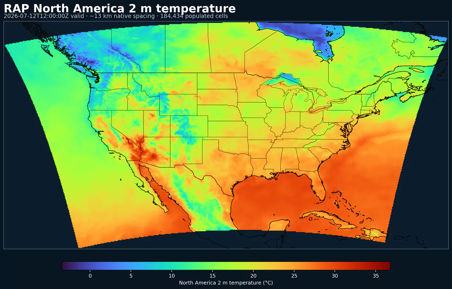
RAP (Rapid Refresh) est le système NOAA/NCEP d'analyse et de prévision méso-échelle à mise à jour horaire, conçu pour la prévision court terme à l'échelle continentale. Il combine un modèle de prévision avec un cycle d'assimilation de données pour produire des analyses et prévisions sur grille très proches du présent.
RAP utilise une version de la dynamique Weather Research and Forecasting (WRF-ARW), initialisée chaque heure par le Rapid Data Assimilation System (RAP-DAS). Ce cycle assimile observations in situ, radiances satellitaires, précipitation dérivée radar et données conventionnelles d'air supérieur.
Son objectif est de capturer à haute fréquence les phénomènes de méso-échelle et de couche limite : développement orageux, passages frontaux et structures de vent de bas niveau. L'assimilation hybride ensemble-3DVar combine la prévision court terme et les observations pour améliorer température, humidité, vent et mouvement vertical.
RAP fonctionne avec un espacement de grille d'environ 13 km. Il donne plus de détail régional qu'un modèle global, tout en gardant une large couverture continentale. Il tourne chaque heure et prolonge ses prévisions jusqu'à environ 51 h, ce qui convient aux produits nécessitant des données récentes et un horizon d'un à deux jours.
RAP est aussi une entrée importante du National Blend of Models (NBM). Dans NBM, il améliore la prévision court terme des produits combinés NOAA. En parallèle, il complète souvent HRRR : HRRR apporte une résolution plus fine sur CONUS, tandis que RAP garde une couverture plus large avec mise à jour horaire.
Dans GribStream, rap est utile pour l'aide à la décision aviation, le suivi de phénomènes violents, la réponse à des situations qui changent vite, la prévision de rampes de production renouvelable, la vérification et les modèles de machine learning orientés nowcasting ou correction de biais.
Cliquez sur un paramètre pour voir ses variantes dans une table compacte avec des sélecteurs JSON prêts à copier. Les codes, niveaux et valeurs de sélecteur restent exactement tels que l'API les expose.
Best (4-layer) lifted index uses parcels from the lowest four model layers to assess stability at 500 hPa. More negative values indicate greater instability.
| Level | Info | Horizon | Introduced | Selector |
|---|---|---|---|---|
180-0 mb above ground |
0h-51h | 2021-02-22 |
{"name":"4LFTX","level":"180-0 mb above ground","info":""}
|
Absolute vorticity combines relative vorticity and planetary vorticity from Earth's rotation. It highlights rotation and dynamical forcing in the flow.
| Level | Info | Horizon | Introduced | Selector |
|---|---|---|---|---|
500 mb |
0h-51h | 2021-02-22 |
{"name":"ABSV","level":"500 mb","info":""}
|
Convective precipitation accumulation represents precipitation produced by the convection scheme during the output period. It isolates convective rainfall from larger-scale precipitation.
| Level | Info | Horizon | Introduced | Selector |
|---|---|---|---|---|
surface |
0h-51h | 2021-02-22 |
{"name":"ACPCP","level":"surface","info":""}
|
Aerosol optical thickness represents the column-integrated attenuation of solar radiation by aerosols. Larger values indicate hazier conditions and reduced surface sunlight.
| Level | Info | Horizon | Introduced | Selector |
|---|---|---|---|---|
entire atmosphere (considered as a single layer) |
0h-51h | 2022-07-19 |
{"name":"AOTK","level":"entire atmosphere (considered as a single layer)","info":""}
|
Accumulated precipitation represents the total water-equivalent amount of rain and snow during the output period. It is a primary field for hydrologic impacts and event totals.
| Level | Info | Horizon | Introduced | Selector |
|---|---|---|---|---|
surface |
0h-51h | 2021-02-22 |
{"name":"APCP","level":"surface","info":""}
|
Accumulated snow depth is the total depth of snow on the ground over the period. It is a physical depth, not water equivalent.
| Level | Info | Horizon | Introduced | Selector |
|---|---|---|---|---|
surface |
0h-51h | 2021-02-22 |
{"name":"ASNOW","level":"surface","info":""}
|
Baseflow‑groundwater runoff represents subsurface drainage from soil into streams. It is a slower component of runoff.
| Level | Info | Horizon | Introduced | Selector |
|---|---|---|---|---|
surface |
0h-51h | 2021-02-22 |
{"name":"BGRUN","level":"surface","info":""}
|
Convective Available Potential Energy (CAPE) quantifies buoyant energy available to rising air parcels. Larger values generally imply stronger potential updrafts and greater convective intensity.
| Level | Info | Horizon | Introduced | Selector |
|---|---|---|---|---|
0-3000 m above ground |
0h-51h | 2021-02-22 |
{"name":"CAPE","level":"0-3000 m above ground","info":""}
|
|
180-0 mb above ground |
0h-51h | 2021-02-22 |
{"name":"CAPE","level":"180-0 mb above ground","info":""}
|
|
255-0 mb above ground |
0h-51h | 2021-02-22 |
{"name":"CAPE","level":"255-0 mb above ground","info":""}
|
|
90-0 mb above ground |
0h-51h | 2021-02-22 |
{"name":"CAPE","level":"90-0 mb above ground","info":""}
|
|
surface |
0h-51h | 2021-02-22 |
{"name":"CAPE","level":"surface","info":""}
|
Categorical indicator of freezing rain occurrence at the surface during the output period.
| Level | Info | Horizon | Introduced | Selector |
|---|---|---|---|---|
surface |
0h-51h | 2021-02-22 |
{"name":"CFRZR","level":"surface","info":""}
|
Categorical indicator of ice pellet (sleet) occurrence at the surface during the output period.
| Level | Info | Horizon | Introduced | Selector |
|---|---|---|---|---|
surface |
0h-51h | 2021-02-22 |
{"name":"CICEP","level":"surface","info":""}
|
Convective Inhibition (CIN) measures the energy barrier that must be overcome to initiate convection. More negative values indicate a stronger cap that can suppress storms.
| Level | Info | Horizon | Introduced | Selector |
|---|---|---|---|---|
180-0 mb above ground |
0h-51h | 2021-02-22 |
{"name":"CIN","level":"180-0 mb above ground","info":""}
|
|
255-0 mb above ground |
0h-51h | 2021-02-22 |
{"name":"CIN","level":"255-0 mb above ground","info":""}
|
|
90-0 mb above ground |
0h-51h | 2021-02-22 |
{"name":"CIN","level":"90-0 mb above ground","info":""}
|
|
surface |
0h-51h | 2021-02-22 |
{"name":"CIN","level":"surface","info":""}
|
Categorical indicator of rain occurrence at the surface during the output period. Useful as a yes/no mask for rain.
| Level | Info | Horizon | Introduced | Selector |
|---|---|---|---|---|
surface |
0h-51h | 2021-02-22 |
{"name":"CRAIN","level":"surface","info":""}
|
Categorical indicator of snow occurrence at the surface during the output period.
| Level | Info | Horizon | Introduced | Selector |
|---|---|---|---|---|
surface |
0h-51h | 2021-02-22 |
{"name":"CSNOW","level":"surface","info":""}
|
Dew point depression is the difference between air temperature and dew point. Small values indicate near‑saturation.
| Level | Info | Horizon | Introduced | Selector |
|---|---|---|---|---|
2 m above ground |
0h-51h | 2021-02-22 |
{"name":"DEPR","level":"2 m above ground","info":""}
|
Dew point temperature is the temperature at which the air becomes saturated. It is a direct measure of moisture content.
| Level | Info | Horizon | Introduced | Selector |
|---|---|---|---|---|
2 m above ground |
0h-51h | 2021-02-22 |
{"name":"DPT","level":"2 m above ground","info":""}
|
Equivalent potential temperature includes the effects of moisture and latent heat. It is conserved for moist adiabatic motions.
| Level | Info | Horizon | Introduced | Selector |
|---|---|---|---|---|
surface |
0h-51h | 2021-02-22 |
{"name":"EPOT","level":"surface","info":""}
|
Freezing rain accumulation is the water-equivalent amount of freezing rain during the period. It relates directly to ice accretion risk.
| Level | Info | Horizon | Introduced | Selector |
|---|---|---|---|---|
surface |
0h-51h | 2021-02-22 |
{"name":"FROZR","level":"surface","info":""}
|
Freezing rain accumulation is the water-equivalent amount of freezing rain during the period. It relates directly to ice accretion risk.
| Level | Info | Horizon | Introduced | Selector |
|---|---|---|---|---|
surface |
0h-51h | 2021-02-22 |
{"name":"FRZR","level":"surface","info":""}
|
Wind gust is the peak short-duration wind speed. It captures brief, hazardous bursts that can exceed sustained winds.
| Level | Info | Horizon | Introduced | Selector |
|---|---|---|---|---|
surface |
0h-51h | 2021-02-22 |
{"name":"GUST","level":"surface","info":""}
|
High cloud cover is the fraction of the grid cell covered by clouds in the upper troposphere. It affects longwave radiation and aviation.
| Level | Info | Horizon | Introduced | Selector |
|---|---|---|---|---|
high cloud layer |
0h-51h | 2021-02-22 |
{"name":"HCDC","level":"high cloud layer","info":""}
|
Geopotential height is the altitude of a pressure surface in the atmosphere. It is the primary field for identifying ridges, troughs, and large‑scale flow patterns.
| Level | Info | Horizon | Introduced | Selector |
|---|---|---|---|---|
0C isotherm |
0h-51h | 2021-02-22 |
{"name":"HGT","level":"0C isotherm","info":""}
|
|
100 mb |
0h-51h | 2021-02-22 |
{"name":"HGT","level":"100 mb","info":""}
|
|
1000 mb |
0h-51h | 2021-02-22 |
{"name":"HGT","level":"1000 mb","info":""}
|
|
125 mb |
0h-51h | 2021-02-22 |
{"name":"HGT","level":"125 mb","info":""}
|
|
150 mb |
0h-51h | 2021-02-22 |
{"name":"HGT","level":"150 mb","info":""}
|
|
175 mb |
0h-51h | 2021-02-22 |
{"name":"HGT","level":"175 mb","info":""}
|
|
200 mb |
0h-51h | 2021-02-22 |
{"name":"HGT","level":"200 mb","info":""}
|
|
225 mb |
0h-51h | 2021-02-22 |
{"name":"HGT","level":"225 mb","info":""}
|
|
250 mb |
0h-51h | 2021-02-22 |
{"name":"HGT","level":"250 mb","info":""}
|
|
253 K level |
0h-51h | 2021-02-22 |
{"name":"HGT","level":"253 K level","info":""}
|
|
263 K level |
0h-51h | 2021-02-22 |
{"name":"HGT","level":"263 K level","info":""}
|
|
275 mb |
0h-51h | 2021-02-22 |
{"name":"HGT","level":"275 mb","info":""}
|
|
300 mb |
0h-51h | 2021-02-22 |
{"name":"HGT","level":"300 mb","info":""}
|
|
325 mb |
0h-51h | 2021-02-22 |
{"name":"HGT","level":"325 mb","info":""}
|
|
350 mb |
0h-51h | 2021-02-22 |
{"name":"HGT","level":"350 mb","info":""}
|
|
375 mb |
0h-51h | 2021-02-22 |
{"name":"HGT","level":"375 mb","info":""}
|
|
400 mb |
0h-51h | 2021-02-22 |
{"name":"HGT","level":"400 mb","info":""}
|
|
425 mb |
0h-51h | 2021-02-22 |
{"name":"HGT","level":"425 mb","info":""}
|
|
450 mb |
0h-51h | 2021-02-22 |
{"name":"HGT","level":"450 mb","info":""}
|
|
475 mb |
0h-51h | 2021-02-22 |
{"name":"HGT","level":"475 mb","info":""}
|
|
500 mb |
0h-51h | 2021-02-22 |
{"name":"HGT","level":"500 mb","info":""}
|
|
525 mb |
0h-51h | 2021-02-22 |
{"name":"HGT","level":"525 mb","info":""}
|
|
550 mb |
0h-51h | 2021-02-22 |
{"name":"HGT","level":"550 mb","info":""}
|
|
575 mb |
0h-51h | 2021-02-22 |
{"name":"HGT","level":"575 mb","info":""}
|
|
600 mb |
0h-51h | 2021-02-22 |
{"name":"HGT","level":"600 mb","info":""}
|
|
625 mb |
0h-51h | 2021-02-22 |
{"name":"HGT","level":"625 mb","info":""}
|
|
650 mb |
0h-51h | 2021-02-22 |
{"name":"HGT","level":"650 mb","info":""}
|
|
675 mb |
0h-51h | 2021-02-22 |
{"name":"HGT","level":"675 mb","info":""}
|
|
700 mb |
0h-51h | 2021-02-22 |
{"name":"HGT","level":"700 mb","info":""}
|
|
725 mb |
0h-51h | 2021-02-22 |
{"name":"HGT","level":"725 mb","info":""}
|
|
750 mb |
0h-51h | 2021-02-22 |
{"name":"HGT","level":"750 mb","info":""}
|
|
775 mb |
0h-51h | 2021-02-22 |
{"name":"HGT","level":"775 mb","info":""}
|
|
800 mb |
0h-51h | 2021-02-22 |
{"name":"HGT","level":"800 mb","info":""}
|
|
825 mb |
0h-51h | 2021-02-22 |
{"name":"HGT","level":"825 mb","info":""}
|
|
850 mb |
0h-51h | 2021-02-22 |
{"name":"HGT","level":"850 mb","info":""}
|
|
875 mb |
0h-51h | 2021-02-22 |
{"name":"HGT","level":"875 mb","info":""}
|
|
900 mb |
0h-51h | 2021-02-22 |
{"name":"HGT","level":"900 mb","info":""}
|
|
925 mb |
0h-51h | 2021-02-22 |
{"name":"HGT","level":"925 mb","info":""}
|
|
950 mb |
0h-51h | 2021-02-22 |
{"name":"HGT","level":"950 mb","info":""}
|
|
975 mb |
0h-51h | 2021-02-22 |
{"name":"HGT","level":"975 mb","info":""}
|
|
cloud base |
0h-51h | 2021-02-22 |
{"name":"HGT","level":"cloud base","info":""}
|
|
cloud ceiling |
0h-51h | 2021-02-22 |
{"name":"HGT","level":"cloud ceiling","info":""}
|
|
cloud top |
0h-51h | 2021-02-22 |
{"name":"HGT","level":"cloud top","info":""}
|
|
convective cloud top level |
0h-51h | 2021-02-22 |
{"name":"HGT","level":"convective cloud top level","info":""}
|
|
equilibrium level |
0h-51h | 2021-02-22 |
{"name":"HGT","level":"equilibrium level","info":""}
|
|
highest tropospheric freezing level |
0h-51h | 2021-02-22 |
{"name":"HGT","level":"highest tropospheric freezing level","info":""}
|
|
level of free convection |
0h-51h | 2022-06-01 |
{"name":"HGT","level":"level of free convection","info":""}
|
|
lowest level of the wet bulb zero |
0h-51h | 2021-02-22 |
{"name":"HGT","level":"lowest level of the wet bulb zero","info":""}
|
|
planetary boundary layer |
0h-51h | 2021-02-22 |
{"name":"HGT","level":"planetary boundary layer","info":""}
|
|
surface |
0h-51h | 2021-02-22 |
{"name":"HGT","level":"surface","info":""}
|
Haines Index combines atmospheric stability and dryness to estimate the potential for large fire growth. Higher values indicate a more favorable environment for extreme fire behavior.
| Level | Info | Horizon | Introduced | Selector |
|---|---|---|---|---|
surface |
0h-51h | 2021-02-22 |
{"name":"HINDEX","level":"surface","info":""}
|
Storm-relative helicity measures the potential for streamwise vorticity to be ingested by a storm updraft. Higher values suggest a greater likelihood of rotating updrafts.
| Level | Info | Horizon | Introduced | Selector |
|---|---|---|---|---|
1000-0 m above ground |
0h-51h | 2021-02-22 |
{"name":"HLCY","level":"1000-0 m above ground","info":""}
|
|
3000-0 m above ground |
0h-51h | 2021-02-22 |
{"name":"HLCY","level":"3000-0 m above ground","info":""}
|
Boundary layer height marks the depth of the turbulent surface-influenced layer. It affects mixing, dispersion, and surface fluxes.
| Level | Info | Horizon | Introduced | Selector |
|---|---|---|---|---|
surface |
0h-51h | 2021-02-22 |
{"name":"HPBL","level":"surface","info":""}
|
Layer thickness is the vertical distance between the bounds of a layer. It helps interpret thermodynamic and lifted-layer diagnostics.
| Level | Info | Horizon | Introduced | Selector |
|---|---|---|---|---|
261 K level - 256 K level |
0h-51h | 2021-02-22 |
{"name":"LAYTH","level":"261 K level - 256 K level","info":""}
|
Low cloud cover is the fraction of the grid cell covered by low clouds. It strongly affects visibility, fog potential, and surface temperatures.
| Level | Info | Horizon | Introduced | Selector |
|---|---|---|---|---|
low cloud layer |
0h-51h | 2021-02-22 |
{"name":"LCDC","level":"low cloud layer","info":""}
|
Lifted Index compares a lifted parcel's temperature to the environment at 500 hPa. More negative values indicate greater instability and thunderstorm potential.
| Level | Info | Horizon | Introduced | Selector |
|---|---|---|---|---|
500-1000 mb |
0h-51h | 2021-02-22 |
{"name":"LFTX","level":"500-1000 mb","info":""}
|
Lightning is a dimensionless model diagnostic in these NOAA mesoscale inventories. Higher values indicate greater modeled lightning or convective electrical activity.
| Level | Info | Horizon | Introduced | Selector |
|---|---|---|---|---|
surface |
0h-51h | 2021-02-22 |
{"name":"LTNG","level":"surface","info":""}
|
Mass density (concentration) represents mass per unit volume of the named species or medium. It is used for concentration and transport analyses.
| Level | Info | Horizon | Introduced | Selector |
|---|---|---|---|---|
8 m above ground |
0h-51h | 2021-02-22 |
{"name":"MASSDEN","level":"8 m above ground","info":""}
|
Mid-level cloud cover is the fraction of the grid cell covered by clouds in the middle troposphere. It influences both shortwave and longwave radiation.
| Level | Info | Horizon | Introduced | Selector |
|---|---|---|---|---|
middle cloud layer |
0h-51h | 2021-02-22 |
{"name":"MCDC","level":"middle cloud layer","info":""}
|
Mean sea level pressure anomaly is the departure of MSLP from a reference or climatology. It highlights large-scale pressure patterns.
| Level | Info | Horizon | Introduced | Selector |
|---|---|---|---|---|
mean sea level |
0h-51h | 2021-02-22 |
{"name":"MSLMA","level":"mean sea level","info":""}
|
Moisture availability represents how much moisture is available at the surface for evaporation. It is used in land-surface and fire-weather diagnostics.
| Level | Info | Horizon | Introduced | Selector |
|---|---|---|---|---|
0 m underground |
0h-51h | 2021-02-22 |
{"name":"MSTAV","level":"0 m underground","info":""}
|
Pressure of the level from which the parcel was lifted indicates the parcel source level used for stability indices. It helps interpret lifted index and CAPE products.
| Level | Info | Horizon | Introduced | Selector |
|---|---|---|---|---|
255-0 mb above ground |
0h-51h | 2021-02-22 |
{"name":"PLPL","level":"255-0 mb above ground","info":""}
|
Potential temperature is the temperature a parcel would have if brought dry‑adiabatically to a reference pressure. It is used for stability.
| Level | Info | Horizon | Introduced | Selector |
|---|---|---|---|---|
2 m above ground |
0h-51h | 2021-02-22 |
{"name":"POT","level":"2 m above ground","info":""}
|
|
tropopause |
0h-51h | 2021-02-22 |
{"name":"POT","level":"tropopause","info":""}
|
Precipitation rate is the total intensity of precipitation over the period. It combines convective and stratiform contributions.
| Level | Info | Horizon | Introduced | Selector |
|---|---|---|---|---|
surface |
0h-51h | 2021-02-22 |
{"name":"PRATE","level":"surface","info":""}
|
Pressure is the atmospheric pressure at the specified level. It is a fundamental mass-field variable for dynamics and thermodynamics.
| Level | Info | Horizon | Introduced | Selector |
|---|---|---|---|---|
0C isotherm |
0h-51h | 2021-02-22 |
{"name":"PRES","level":"0C isotherm","info":""}
|
|
80 m above ground |
0h-51h | 2021-02-22 |
{"name":"PRES","level":"80 m above ground","info":""}
|
|
highest tropospheric freezing level |
0h-51h | 2021-02-22 |
{"name":"PRES","level":"highest tropospheric freezing level","info":""}
|
|
max wind |
0h-51h | 2021-02-22 |
{"name":"PRES","level":"max wind","info":""}
|
|
surface |
0h-51h | 2021-02-22 |
{"name":"PRES","level":"surface","info":""}
|
|
tropopause |
0h-51h | 2021-02-22 |
{"name":"PRES","level":"tropopause","info":""}
|
Precipitable water is the total column water vapor from the surface to the top of the atmosphere. It is a key moisture indicator.
| Level | Info | Horizon | Introduced | Selector |
|---|---|---|---|---|
entire atmosphere (considered as a single layer) |
0h-51h | 2021-02-22 |
{"name":"PWAT","level":"entire atmosphere (considered as a single layer)","info":""}
|
Composite reflectivity is the maximum reflectivity in the column. It is a standard radar‑style field for identifying convective cores and precipitation intensity.
| Level | Info | Horizon | Introduced | Selector |
|---|---|---|---|---|
entire atmosphere |
0h-51h | 2021-02-22 |
{"name":"REFC","level":"entire atmosphere","info":""}
|
Reflectivity is a radar‑style measure of hydrometeor concentration at a given level. Higher values generally correspond to heavier precipitation.
| Level | Info | Horizon | Introduced | Selector |
|---|---|---|---|---|
1000 m above ground |
0h-51h | 2021-02-22 |
{"name":"REFD","level":"1000 m above ground","info":""}
|
|
4000 m above ground |
0h-51h | 2021-02-22 |
{"name":"REFD","level":"4000 m above ground","info":""}
|
Echo top height is the altitude of the highest reflectivity in the column. It is a proxy for storm depth and convective vigor.
| Level | Info | Horizon | Introduced | Selector |
|---|---|---|---|---|
entire atmosphere (considered as a single layer) |
0h-51h | 2021-02-22 |
{"name":"RETOP","level":"entire atmosphere (considered as a single layer)","info":""}
|
Relative humidity describes how close the air is to saturation at the specified level. High values favor cloud formation.
| Level | Info | Horizon | Introduced | Selector |
|---|---|---|---|---|
0C isotherm |
0h-51h | 2021-02-22 |
{"name":"RH","level":"0C isotherm","info":""}
|
|
100 mb |
0h-51h | 2021-02-22 |
{"name":"RH","level":"100 mb","info":""}
|
|
1000 mb |
0h-51h | 2021-02-22 |
{"name":"RH","level":"1000 mb","info":""}
|
|
120-90 mb above ground |
0h-51h | 2021-02-22 |
{"name":"RH","level":"120-90 mb above ground","info":""}
|
|
125 mb |
0h-51h | 2021-02-22 |
{"name":"RH","level":"125 mb","info":""}
|
|
150 mb |
0h-51h | 2021-02-22 |
{"name":"RH","level":"150 mb","info":""}
|
|
150-120 mb above ground |
0h-51h | 2021-02-22 |
{"name":"RH","level":"150-120 mb above ground","info":""}
|
|
175 mb |
0h-51h | 2021-02-22 |
{"name":"RH","level":"175 mb","info":""}
|
|
180-150 mb above ground |
0h-51h | 2021-02-22 |
{"name":"RH","level":"180-150 mb above ground","info":""}
|
|
2 m above ground |
0h-51h | 2021-02-22 |
{"name":"RH","level":"2 m above ground","info":""}
|
|
200 mb |
0h-51h | 2021-02-22 |
{"name":"RH","level":"200 mb","info":""}
|
|
225 mb |
0h-51h | 2021-02-22 |
{"name":"RH","level":"225 mb","info":""}
|
|
250 mb |
0h-51h | 2021-02-22 |
{"name":"RH","level":"250 mb","info":""}
|
|
275 mb |
0h-51h | 2021-02-22 |
{"name":"RH","level":"275 mb","info":""}
|
|
30-0 mb above ground |
0h-51h | 2021-02-22 |
{"name":"RH","level":"30-0 mb above ground","info":""}
|
|
300 mb |
0h-51h | 2021-02-22 |
{"name":"RH","level":"300 mb","info":""}
|
|
325 mb |
0h-51h | 2021-02-22 |
{"name":"RH","level":"325 mb","info":""}
|
|
350 mb |
0h-51h | 2021-02-22 |
{"name":"RH","level":"350 mb","info":""}
|
|
375 mb |
0h-51h | 2021-02-22 |
{"name":"RH","level":"375 mb","info":""}
|
|
400 mb |
0h-51h | 2021-02-22 |
{"name":"RH","level":"400 mb","info":""}
|
|
425 mb |
0h-51h | 2021-02-22 |
{"name":"RH","level":"425 mb","info":""}
|
|
450 mb |
0h-51h | 2021-02-22 |
{"name":"RH","level":"450 mb","info":""}
|
|
475 mb |
0h-51h | 2021-02-22 |
{"name":"RH","level":"475 mb","info":""}
|
|
500 mb |
0h-51h | 2021-02-22 |
{"name":"RH","level":"500 mb","info":""}
|
|
525 mb |
0h-51h | 2021-02-22 |
{"name":"RH","level":"525 mb","info":""}
|
|
550 mb |
0h-51h | 2021-02-22 |
{"name":"RH","level":"550 mb","info":""}
|
|
575 mb |
0h-51h | 2021-02-22 |
{"name":"RH","level":"575 mb","info":""}
|
|
60-30 mb above ground |
0h-51h | 2021-02-22 |
{"name":"RH","level":"60-30 mb above ground","info":""}
|
|
600 mb |
0h-51h | 2021-02-22 |
{"name":"RH","level":"600 mb","info":""}
|
|
625 mb |
0h-51h | 2021-02-22 |
{"name":"RH","level":"625 mb","info":""}
|
|
650 mb |
0h-51h | 2021-02-22 |
{"name":"RH","level":"650 mb","info":""}
|
|
675 mb |
0h-51h | 2021-02-22 |
{"name":"RH","level":"675 mb","info":""}
|
|
700 mb |
0h-51h | 2021-02-22 |
{"name":"RH","level":"700 mb","info":""}
|
|
725 mb |
0h-51h | 2021-02-22 |
{"name":"RH","level":"725 mb","info":""}
|
|
750 mb |
0h-51h | 2021-02-22 |
{"name":"RH","level":"750 mb","info":""}
|
|
775 mb |
0h-51h | 2021-02-22 |
{"name":"RH","level":"775 mb","info":""}
|
|
800 mb |
0h-51h | 2021-02-22 |
{"name":"RH","level":"800 mb","info":""}
|
|
825 mb |
0h-51h | 2021-02-22 |
{"name":"RH","level":"825 mb","info":""}
|
|
850 mb |
0h-51h | 2021-02-22 |
{"name":"RH","level":"850 mb","info":""}
|
|
875 mb |
0h-51h | 2021-02-22 |
{"name":"RH","level":"875 mb","info":""}
|
|
90-60 mb above ground |
0h-51h | 2021-02-22 |
{"name":"RH","level":"90-60 mb above ground","info":""}
|
|
900 mb |
0h-51h | 2021-02-22 |
{"name":"RH","level":"900 mb","info":""}
|
|
925 mb |
0h-51h | 2021-02-22 |
{"name":"RH","level":"925 mb","info":""}
|
|
950 mb |
0h-51h | 2021-02-22 |
{"name":"RH","level":"950 mb","info":""}
|
|
975 mb |
0h-51h | 2021-02-22 |
{"name":"RH","level":"975 mb","info":""}
|
|
highest tropospheric freezing level |
0h-51h | 2021-02-22 |
{"name":"RH","level":"highest tropospheric freezing level","info":""}
|
Relative humidity with respect to precipitable water is a column‑scale moisture indicator based on total water vapor content.
| Level | Info | Horizon | Introduced | Selector |
|---|---|---|---|---|
entire atmosphere |
0h-51h | 2021-02-22 |
{"name":"RHPW","level":"entire atmosphere","info":""}
|
Simulated brightness temperature for GOES-11 channel 3 represents modeled radiance converted to an equivalent blackbody temperature. It supports satellite comparison and cloud diagnostics.
| Level | Info | Horizon | Introduced | Selector |
|---|---|---|---|---|
top of atmosphere |
0h-51h | 2021-02-22 |
{"name":"SBT113","level":"top of atmosphere","info":""}
|
Simulated brightness temperature for GOES-11 channel 4 represents modeled radiance converted to an equivalent blackbody temperature. It supports satellite comparison and cloud diagnostics.
| Level | Info | Horizon | Introduced | Selector |
|---|---|---|---|---|
top of atmosphere |
0h-51h | 2021-02-22 |
{"name":"SBT114","level":"top of atmosphere","info":""}
|
Simulated brightness temperature for GOES-12 channel 3 represents modeled radiance converted to an equivalent blackbody temperature. It supports satellite comparison and cloud diagnostics.
| Level | Info | Horizon | Introduced | Selector |
|---|---|---|---|---|
top of atmosphere |
0h-51h | 2021-02-22 |
{"name":"SBT123","level":"top of atmosphere","info":""}
|
Simulated brightness temperature for GOES-12 channel 4 represents modeled radiance converted to an equivalent blackbody temperature. It supports satellite comparison and cloud diagnostics.
| Level | Info | Horizon | Introduced | Selector |
|---|---|---|---|---|
top of atmosphere |
0h-51h | 2021-02-22 |
{"name":"SBT124","level":"top of atmosphere","info":""}
|
Snow depth is the physical thickness of the snowpack. It is distinct from snow water equivalent, which measures water content.
| Level | Info | Horizon | Introduced | Selector |
|---|---|---|---|---|
surface |
0h-51h | 2021-02-22 |
{"name":"SNOD","level":"surface","info":""}
|
Specific humidity is the mass of water vapor per mass of air at the specified level. It is central to moisture transport.
| Level | Info | Horizon | Introduced | Selector |
|---|---|---|---|---|
2 m above ground |
0h-51h | 2021-02-22 |
{"name":"SPFH","level":"2 m above ground","info":""}
|
|
80 m above ground |
0h-51h | 2021-02-22 |
{"name":"SPFH","level":"80 m above ground","info":""}
|
Storm surface runoff represents overland flow generated by rainfall or snowmelt. It responds quickly to heavy precipitation.
| Level | Info | Horizon | Introduced | Selector |
|---|---|---|---|---|
surface |
0h-51h | 2021-02-22 |
{"name":"SSRUN","level":"surface","info":""}
|
Total cloud cover is the fraction of the grid cell covered by clouds at any level. It influences radiation, temperature, and visibility.
| Level | Info | Horizon | Introduced | Selector |
|---|---|---|---|---|
boundary layer cloud layer |
0h-51h | 2021-02-22 |
{"name":"TCDC","level":"boundary layer cloud layer","info":""}
|
|
entire atmosphere |
0h-51h | 2021-02-22 |
{"name":"TCDC","level":"entire atmosphere","info":""}
|
Air temperature is the thermal state of the atmosphere at the specified level. It influences density, stability, and energy exchange.
| Level | Info | Horizon | Introduced | Selector |
|---|---|---|---|---|
100 mb |
0h-51h | 2021-02-22 |
{"name":"TMP","level":"100 mb","info":""}
|
|
1000 mb |
0h-51h | 2021-02-22 |
{"name":"TMP","level":"1000 mb","info":""}
|
|
120-90 mb above ground |
0h-51h | 2021-02-22 |
{"name":"TMP","level":"120-90 mb above ground","info":""}
|
|
125 mb |
0h-51h | 2021-02-22 |
{"name":"TMP","level":"125 mb","info":""}
|
|
150 mb |
0h-51h | 2021-02-22 |
{"name":"TMP","level":"150 mb","info":""}
|
|
150-120 mb above ground |
0h-51h | 2021-02-22 |
{"name":"TMP","level":"150-120 mb above ground","info":""}
|
|
175 mb |
0h-51h | 2021-02-22 |
{"name":"TMP","level":"175 mb","info":""}
|
|
180-150 mb above ground |
0h-51h | 2021-02-22 |
{"name":"TMP","level":"180-150 mb above ground","info":""}
|
|
2 m above ground |
0h-51h | 2021-02-22 |
{"name":"TMP","level":"2 m above ground","info":""}
|
|
200 mb |
0h-51h | 2021-02-22 |
{"name":"TMP","level":"200 mb","info":""}
|
|
225 mb |
0h-51h | 2021-02-22 |
{"name":"TMP","level":"225 mb","info":""}
|
|
250 mb |
0h-51h | 2021-02-22 |
{"name":"TMP","level":"250 mb","info":""}
|
|
275 mb |
0h-51h | 2021-02-22 |
{"name":"TMP","level":"275 mb","info":""}
|
|
30-0 mb above ground |
0h-51h | 2021-02-22 |
{"name":"TMP","level":"30-0 mb above ground","info":""}
|
|
300 mb |
0h-51h | 2021-02-22 |
{"name":"TMP","level":"300 mb","info":""}
|
|
325 mb |
0h-51h | 2021-02-22 |
{"name":"TMP","level":"325 mb","info":""}
|
|
350 mb |
0h-51h | 2021-02-22 |
{"name":"TMP","level":"350 mb","info":""}
|
|
375 mb |
0h-51h | 2021-02-22 |
{"name":"TMP","level":"375 mb","info":""}
|
|
400 mb |
0h-51h | 2021-02-22 |
{"name":"TMP","level":"400 mb","info":""}
|
|
425 mb |
0h-51h | 2021-02-22 |
{"name":"TMP","level":"425 mb","info":""}
|
|
450 mb |
0h-51h | 2021-02-22 |
{"name":"TMP","level":"450 mb","info":""}
|
|
475 mb |
0h-51h | 2021-02-22 |
{"name":"TMP","level":"475 mb","info":""}
|
|
500 mb |
0h-51h | 2021-02-22 |
{"name":"TMP","level":"500 mb","info":""}
|
|
525 mb |
0h-51h | 2021-02-22 |
{"name":"TMP","level":"525 mb","info":""}
|
|
550 mb |
0h-51h | 2021-02-22 |
{"name":"TMP","level":"550 mb","info":""}
|
|
575 mb |
0h-51h | 2021-02-22 |
{"name":"TMP","level":"575 mb","info":""}
|
|
60-30 mb above ground |
0h-51h | 2021-02-22 |
{"name":"TMP","level":"60-30 mb above ground","info":""}
|
|
600 mb |
0h-51h | 2021-02-22 |
{"name":"TMP","level":"600 mb","info":""}
|
|
625 mb |
0h-51h | 2021-02-22 |
{"name":"TMP","level":"625 mb","info":""}
|
|
650 mb |
0h-51h | 2021-02-22 |
{"name":"TMP","level":"650 mb","info":""}
|
|
675 mb |
0h-51h | 2021-02-22 |
{"name":"TMP","level":"675 mb","info":""}
|
|
700 mb |
0h-51h | 2021-02-22 |
{"name":"TMP","level":"700 mb","info":""}
|
|
725 mb |
0h-51h | 2021-02-22 |
{"name":"TMP","level":"725 mb","info":""}
|
|
750 mb |
0h-51h | 2021-02-22 |
{"name":"TMP","level":"750 mb","info":""}
|
|
775 mb |
0h-51h | 2021-02-22 |
{"name":"TMP","level":"775 mb","info":""}
|
|
80 m above ground |
0h-51h | 2021-02-22 |
{"name":"TMP","level":"80 m above ground","info":""}
|
|
800 mb |
0h-51h | 2021-02-22 |
{"name":"TMP","level":"800 mb","info":""}
|
|
825 mb |
0h-51h | 2021-02-22 |
{"name":"TMP","level":"825 mb","info":""}
|
|
850 mb |
0h-51h | 2021-02-22 |
{"name":"TMP","level":"850 mb","info":""}
|
|
875 mb |
0h-51h | 2021-02-22 |
{"name":"TMP","level":"875 mb","info":""}
|
|
90-60 mb above ground |
0h-51h | 2021-02-22 |
{"name":"TMP","level":"90-60 mb above ground","info":""}
|
|
900 mb |
0h-51h | 2021-02-22 |
{"name":"TMP","level":"900 mb","info":""}
|
|
925 mb |
0h-51h | 2021-02-22 |
{"name":"TMP","level":"925 mb","info":""}
|
|
950 mb |
0h-51h | 2021-02-22 |
{"name":"TMP","level":"950 mb","info":""}
|
|
975 mb |
0h-51h | 2021-02-22 |
{"name":"TMP","level":"975 mb","info":""}
|
|
surface |
0h-51h | 2021-02-22 |
{"name":"TMP","level":"surface","info":""}
|
|
tropopause |
0h-51h | 2021-02-22 |
{"name":"TMP","level":"tropopause","info":""}
|
U‑component of wind is the east‑west component of the horizontal wind. Combine with v for speed and direction.
| Level | Info | Horizon | Introduced | Selector |
|---|---|---|---|---|
10 m above ground |
0h-51h | 2021-02-22 |
{"name":"UGRD","level":"10 m above ground","info":""}
|
|
100 mb |
0h-51h | 2021-02-22 |
{"name":"UGRD","level":"100 mb","info":""}
|
|
1000 mb |
0h-51h | 2021-02-22 |
{"name":"UGRD","level":"1000 mb","info":""}
|
|
120-90 mb above ground |
0h-51h | 2021-02-22 |
{"name":"UGRD","level":"120-90 mb above ground","info":""}
|
|
125 mb |
0h-51h | 2021-02-22 |
{"name":"UGRD","level":"125 mb","info":""}
|
|
150 mb |
0h-51h | 2021-02-22 |
{"name":"UGRD","level":"150 mb","info":""}
|
|
150-120 mb above ground |
0h-51h | 2021-02-22 |
{"name":"UGRD","level":"150-120 mb above ground","info":""}
|
|
175 mb |
0h-51h | 2021-02-22 |
{"name":"UGRD","level":"175 mb","info":""}
|
|
180-150 mb above ground |
0h-51h | 2021-02-22 |
{"name":"UGRD","level":"180-150 mb above ground","info":""}
|
|
200 mb |
0h-51h | 2021-02-22 |
{"name":"UGRD","level":"200 mb","info":""}
|
|
225 mb |
0h-51h | 2021-02-22 |
{"name":"UGRD","level":"225 mb","info":""}
|
|
250 mb |
0h-51h | 2021-02-22 |
{"name":"UGRD","level":"250 mb","info":""}
|
|
275 mb |
0h-51h | 2021-02-22 |
{"name":"UGRD","level":"275 mb","info":""}
|
|
30-0 mb above ground |
0h-51h | 2021-02-22 |
{"name":"UGRD","level":"30-0 mb above ground","info":""}
|
|
300 mb |
0h-51h | 2021-02-22 |
{"name":"UGRD","level":"300 mb","info":""}
|
|
325 mb |
0h-51h | 2021-02-22 |
{"name":"UGRD","level":"325 mb","info":""}
|
|
350 mb |
0h-51h | 2021-02-22 |
{"name":"UGRD","level":"350 mb","info":""}
|
|
375 mb |
0h-51h | 2021-02-22 |
{"name":"UGRD","level":"375 mb","info":""}
|
|
400 mb |
0h-51h | 2021-02-22 |
{"name":"UGRD","level":"400 mb","info":""}
|
|
425 mb |
0h-51h | 2021-02-22 |
{"name":"UGRD","level":"425 mb","info":""}
|
|
450 mb |
0h-51h | 2021-02-22 |
{"name":"UGRD","level":"450 mb","info":""}
|
|
475 mb |
0h-51h | 2021-02-22 |
{"name":"UGRD","level":"475 mb","info":""}
|
|
500 mb |
0h-51h | 2021-02-22 |
{"name":"UGRD","level":"500 mb","info":""}
|
|
525 mb |
0h-51h | 2021-02-22 |
{"name":"UGRD","level":"525 mb","info":""}
|
|
550 mb |
0h-51h | 2021-02-22 |
{"name":"UGRD","level":"550 mb","info":""}
|
|
575 mb |
0h-51h | 2021-02-22 |
{"name":"UGRD","level":"575 mb","info":""}
|
|
60-30 mb above ground |
0h-51h | 2021-02-22 |
{"name":"UGRD","level":"60-30 mb above ground","info":""}
|
|
600 mb |
0h-51h | 2021-02-22 |
{"name":"UGRD","level":"600 mb","info":""}
|
|
625 mb |
0h-51h | 2021-02-22 |
{"name":"UGRD","level":"625 mb","info":""}
|
|
650 mb |
0h-51h | 2021-02-22 |
{"name":"UGRD","level":"650 mb","info":""}
|
|
675 mb |
0h-51h | 2021-02-22 |
{"name":"UGRD","level":"675 mb","info":""}
|
|
700 mb |
0h-51h | 2021-02-22 |
{"name":"UGRD","level":"700 mb","info":""}
|
|
725 mb |
0h-51h | 2021-02-22 |
{"name":"UGRD","level":"725 mb","info":""}
|
|
750 mb |
0h-51h | 2021-02-22 |
{"name":"UGRD","level":"750 mb","info":""}
|
|
775 mb |
0h-51h | 2021-02-22 |
{"name":"UGRD","level":"775 mb","info":""}
|
|
80 m above ground |
0h-51h | 2021-02-22 |
{"name":"UGRD","level":"80 m above ground","info":""}
|
|
800 mb |
0h-51h | 2021-02-22 |
{"name":"UGRD","level":"800 mb","info":""}
|
|
825 mb |
0h-51h | 2021-02-22 |
{"name":"UGRD","level":"825 mb","info":""}
|
|
850 mb |
0h-51h | 2021-02-22 |
{"name":"UGRD","level":"850 mb","info":""}
|
|
875 mb |
0h-51h | 2021-02-22 |
{"name":"UGRD","level":"875 mb","info":""}
|
|
90-60 mb above ground |
0h-51h | 2021-02-22 |
{"name":"UGRD","level":"90-60 mb above ground","info":""}
|
|
900 mb |
0h-51h | 2021-02-22 |
{"name":"UGRD","level":"900 mb","info":""}
|
|
925 mb |
0h-51h | 2021-02-22 |
{"name":"UGRD","level":"925 mb","info":""}
|
|
950 mb |
0h-51h | 2021-02-22 |
{"name":"UGRD","level":"950 mb","info":""}
|
|
975 mb |
0h-51h | 2021-02-22 |
{"name":"UGRD","level":"975 mb","info":""}
|
|
max wind |
0h-51h | 2021-02-22 |
{"name":"UGRD","level":"max wind","info":""}
|
|
tropopause |
0h-51h | 2021-02-22 |
{"name":"UGRD","level":"tropopause","info":""}
|
U‑component of storm motion is the east‑west component of the storm translation vector.
| Level | Info | Horizon | Introduced | Selector |
|---|---|---|---|---|
0-6000 m above ground |
0h-51h | 2021-02-22 |
{"name":"USTM","level":"0-6000 m above ground","info":""}
|
V‑component of wind is the north‑south component of the horizontal wind. Combine with u for speed and direction.
| Level | Info | Horizon | Introduced | Selector |
|---|---|---|---|---|
10 m above ground |
0h-51h | 2021-02-22 |
{"name":"VGRD","level":"10 m above ground","info":""}
|
|
100 mb |
0h-51h | 2021-02-22 |
{"name":"VGRD","level":"100 mb","info":""}
|
|
1000 mb |
0h-51h | 2021-02-22 |
{"name":"VGRD","level":"1000 mb","info":""}
|
|
120-90 mb above ground |
0h-51h | 2021-02-22 |
{"name":"VGRD","level":"120-90 mb above ground","info":""}
|
|
125 mb |
0h-51h | 2021-02-22 |
{"name":"VGRD","level":"125 mb","info":""}
|
|
150 mb |
0h-51h | 2021-02-22 |
{"name":"VGRD","level":"150 mb","info":""}
|
|
150-120 mb above ground |
0h-51h | 2021-02-22 |
{"name":"VGRD","level":"150-120 mb above ground","info":""}
|
|
175 mb |
0h-51h | 2021-02-22 |
{"name":"VGRD","level":"175 mb","info":""}
|
|
180-150 mb above ground |
0h-51h | 2021-02-22 |
{"name":"VGRD","level":"180-150 mb above ground","info":""}
|
|
200 mb |
0h-51h | 2021-02-22 |
{"name":"VGRD","level":"200 mb","info":""}
|
|
225 mb |
0h-51h | 2021-02-22 |
{"name":"VGRD","level":"225 mb","info":""}
|
|
250 mb |
0h-51h | 2021-02-22 |
{"name":"VGRD","level":"250 mb","info":""}
|
|
275 mb |
0h-51h | 2021-02-22 |
{"name":"VGRD","level":"275 mb","info":""}
|
|
30-0 mb above ground |
0h-51h | 2021-02-22 |
{"name":"VGRD","level":"30-0 mb above ground","info":""}
|
|
300 mb |
0h-51h | 2021-02-22 |
{"name":"VGRD","level":"300 mb","info":""}
|
|
325 mb |
0h-51h | 2021-02-22 |
{"name":"VGRD","level":"325 mb","info":""}
|
|
350 mb |
0h-51h | 2021-02-22 |
{"name":"VGRD","level":"350 mb","info":""}
|
|
375 mb |
0h-51h | 2021-02-22 |
{"name":"VGRD","level":"375 mb","info":""}
|
|
400 mb |
0h-51h | 2021-02-22 |
{"name":"VGRD","level":"400 mb","info":""}
|
|
425 mb |
0h-51h | 2021-02-22 |
{"name":"VGRD","level":"425 mb","info":""}
|
|
450 mb |
0h-51h | 2021-02-22 |
{"name":"VGRD","level":"450 mb","info":""}
|
|
475 mb |
0h-51h | 2021-02-22 |
{"name":"VGRD","level":"475 mb","info":""}
|
|
500 mb |
0h-51h | 2021-02-22 |
{"name":"VGRD","level":"500 mb","info":""}
|
|
525 mb |
0h-51h | 2021-02-22 |
{"name":"VGRD","level":"525 mb","info":""}
|
|
550 mb |
0h-51h | 2021-02-22 |
{"name":"VGRD","level":"550 mb","info":""}
|
|
575 mb |
0h-51h | 2021-02-22 |
{"name":"VGRD","level":"575 mb","info":""}
|
|
60-30 mb above ground |
0h-51h | 2021-02-22 |
{"name":"VGRD","level":"60-30 mb above ground","info":""}
|
|
600 mb |
0h-51h | 2021-02-22 |
{"name":"VGRD","level":"600 mb","info":""}
|
|
625 mb |
0h-51h | 2021-02-22 |
{"name":"VGRD","level":"625 mb","info":""}
|
|
650 mb |
0h-51h | 2021-02-22 |
{"name":"VGRD","level":"650 mb","info":""}
|
|
675 mb |
0h-51h | 2021-02-22 |
{"name":"VGRD","level":"675 mb","info":""}
|
|
700 mb |
0h-51h | 2021-02-22 |
{"name":"VGRD","level":"700 mb","info":""}
|
|
725 mb |
0h-51h | 2021-02-22 |
{"name":"VGRD","level":"725 mb","info":""}
|
|
750 mb |
0h-51h | 2021-02-22 |
{"name":"VGRD","level":"750 mb","info":""}
|
|
775 mb |
0h-51h | 2021-02-22 |
{"name":"VGRD","level":"775 mb","info":""}
|
|
80 m above ground |
0h-51h | 2021-02-22 |
{"name":"VGRD","level":"80 m above ground","info":""}
|
|
800 mb |
0h-51h | 2021-02-22 |
{"name":"VGRD","level":"800 mb","info":""}
|
|
825 mb |
0h-51h | 2021-02-22 |
{"name":"VGRD","level":"825 mb","info":""}
|
|
850 mb |
0h-51h | 2021-02-22 |
{"name":"VGRD","level":"850 mb","info":""}
|
|
875 mb |
0h-51h | 2021-02-22 |
{"name":"VGRD","level":"875 mb","info":""}
|
|
90-60 mb above ground |
0h-51h | 2021-02-22 |
{"name":"VGRD","level":"90-60 mb above ground","info":""}
|
|
900 mb |
0h-51h | 2021-02-22 |
{"name":"VGRD","level":"900 mb","info":""}
|
|
925 mb |
0h-51h | 2021-02-22 |
{"name":"VGRD","level":"925 mb","info":""}
|
|
950 mb |
0h-51h | 2021-02-22 |
{"name":"VGRD","level":"950 mb","info":""}
|
|
975 mb |
0h-51h | 2021-02-22 |
{"name":"VGRD","level":"975 mb","info":""}
|
|
max wind |
0h-51h | 2021-02-22 |
{"name":"VGRD","level":"max wind","info":""}
|
|
tropopause |
0h-51h | 2021-02-22 |
{"name":"VGRD","level":"tropopause","info":""}
|
Horizontal visibility at the surface. Lower values indicate reduced visibility due to fog, precipitation, or aerosols.
| Level | Info | Horizon | Introduced | Selector |
|---|---|---|---|---|
surface |
0h-51h | 2021-02-22 |
{"name":"VIS","level":"surface","info":""}
|
V-component storm motion represents the north-south component of storm motion. Positive values indicate motion toward the north.
| Level | Info | Horizon | Introduced | Selector |
|---|---|---|---|---|
0-6000 m above ground |
0h-51h | 2021-02-22 |
{"name":"VSTM","level":"0-6000 m above ground","info":""}
|
Vertical u-component shear describes how the east-west wind component changes with height.
| Level | Info | Horizon | Introduced | Selector |
|---|---|---|---|---|
0-6000 m above ground |
0h-51h | 2021-02-22 |
{"name":"VUCSH","level":"0-6000 m above ground","info":""}
|
Vertical v-component shear describes how the north-south wind component changes with height.
| Level | Info | Horizon | Introduced | Selector |
|---|---|---|---|---|
0-6000 m above ground |
0h-51h | 2021-02-22 |
{"name":"VVCSH","level":"0-6000 m above ground","info":""}
|
Vertical velocity in pressure coordinates (omega). Negative values indicate upward motion (rising air); positive values indicate subsidence.
| Level | Info | Horizon | Introduced | Selector |
|---|---|---|---|---|
100 mb |
0h-51h | 2021-02-22 |
{"name":"VVEL","level":"100 mb","info":""}
|
|
1000 mb |
0h-51h | 2021-02-22 |
{"name":"VVEL","level":"1000 mb","info":""}
|
|
120-90 mb above ground |
0h-51h | 2021-02-22 |
{"name":"VVEL","level":"120-90 mb above ground","info":""}
|
|
125 mb |
0h-51h | 2021-02-22 |
{"name":"VVEL","level":"125 mb","info":""}
|
|
150 mb |
0h-51h | 2021-02-22 |
{"name":"VVEL","level":"150 mb","info":""}
|
|
150-120 mb above ground |
0h-51h | 2021-02-22 |
{"name":"VVEL","level":"150-120 mb above ground","info":""}
|
|
175 mb |
0h-51h | 2021-02-22 |
{"name":"VVEL","level":"175 mb","info":""}
|
|
180-150 mb above ground |
0h-51h | 2021-02-22 |
{"name":"VVEL","level":"180-150 mb above ground","info":""}
|
|
200 mb |
0h-51h | 2021-02-22 |
{"name":"VVEL","level":"200 mb","info":""}
|
|
225 mb |
0h-51h | 2021-02-22 |
{"name":"VVEL","level":"225 mb","info":""}
|
|
250 mb |
0h-51h | 2021-02-22 |
{"name":"VVEL","level":"250 mb","info":""}
|
|
275 mb |
0h-51h | 2021-02-22 |
{"name":"VVEL","level":"275 mb","info":""}
|
|
30-0 mb above ground |
0h-51h | 2021-02-22 |
{"name":"VVEL","level":"30-0 mb above ground","info":""}
|
|
300 mb |
0h-51h | 2021-02-22 |
{"name":"VVEL","level":"300 mb","info":""}
|
|
325 mb |
0h-51h | 2021-02-22 |
{"name":"VVEL","level":"325 mb","info":""}
|
|
350 mb |
0h-51h | 2021-02-22 |
{"name":"VVEL","level":"350 mb","info":""}
|
|
375 mb |
0h-51h | 2021-02-22 |
{"name":"VVEL","level":"375 mb","info":""}
|
|
400 mb |
0h-51h | 2021-02-22 |
{"name":"VVEL","level":"400 mb","info":""}
|
|
425 mb |
0h-51h | 2021-02-22 |
{"name":"VVEL","level":"425 mb","info":""}
|
|
450 mb |
0h-51h | 2021-02-22 |
{"name":"VVEL","level":"450 mb","info":""}
|
|
475 mb |
0h-51h | 2021-02-22 |
{"name":"VVEL","level":"475 mb","info":""}
|
|
500 mb |
0h-51h | 2021-02-22 |
{"name":"VVEL","level":"500 mb","info":""}
|
|
525 mb |
0h-51h | 2021-02-22 |
{"name":"VVEL","level":"525 mb","info":""}
|
|
550 mb |
0h-51h | 2021-02-22 |
{"name":"VVEL","level":"550 mb","info":""}
|
|
575 mb |
0h-51h | 2021-02-22 |
{"name":"VVEL","level":"575 mb","info":""}
|
|
60-30 mb above ground |
0h-51h | 2021-02-22 |
{"name":"VVEL","level":"60-30 mb above ground","info":""}
|
|
600 mb |
0h-51h | 2021-02-22 |
{"name":"VVEL","level":"600 mb","info":""}
|
|
625 mb |
0h-51h | 2021-02-22 |
{"name":"VVEL","level":"625 mb","info":""}
|
|
650 mb |
0h-51h | 2021-02-22 |
{"name":"VVEL","level":"650 mb","info":""}
|
|
675 mb |
0h-51h | 2021-02-22 |
{"name":"VVEL","level":"675 mb","info":""}
|
|
700 mb |
0h-51h | 2021-02-22 |
{"name":"VVEL","level":"700 mb","info":""}
|
|
725 mb |
0h-51h | 2021-02-22 |
{"name":"VVEL","level":"725 mb","info":""}
|
|
750 mb |
0h-51h | 2021-02-22 |
{"name":"VVEL","level":"750 mb","info":""}
|
|
775 mb |
0h-51h | 2021-02-22 |
{"name":"VVEL","level":"775 mb","info":""}
|
|
800 mb |
0h-51h | 2021-02-22 |
{"name":"VVEL","level":"800 mb","info":""}
|
|
825 mb |
0h-51h | 2021-02-22 |
{"name":"VVEL","level":"825 mb","info":""}
|
|
850 mb |
0h-51h | 2021-02-22 |
{"name":"VVEL","level":"850 mb","info":""}
|
|
875 mb |
0h-51h | 2021-02-22 |
{"name":"VVEL","level":"875 mb","info":""}
|
|
90-60 mb above ground |
0h-51h | 2021-02-22 |
{"name":"VVEL","level":"90-60 mb above ground","info":""}
|
|
900 mb |
0h-51h | 2021-02-22 |
{"name":"VVEL","level":"900 mb","info":""}
|
|
925 mb |
0h-51h | 2021-02-22 |
{"name":"VVEL","level":"925 mb","info":""}
|
|
950 mb |
0h-51h | 2021-02-22 |
{"name":"VVEL","level":"950 mb","info":""}
|
|
975 mb |
0h-51h | 2021-02-22 |
{"name":"VVEL","level":"975 mb","info":""}
|
Snow water equivalent (SWE) is the total liquid water stored in the snowpack. It integrates depth and density of existing snow.
| Level | Info | Horizon | Introduced | Selector |
|---|---|---|---|---|
surface |
0h-51h | 2021-02-22 |
{"name":"WEASD","level":"surface","info":""}
|
Aucun paramètre ne correspond à la recherche.