Ceiling height is the altitude of the lowest cloud base that covers a significant portion of the sky. It is a key aviation and surface-visibility metric.
- Units: m.
Codice GribStream: urma
URMA (Unrestricted Mesoscale Analysis) è l'analisi oraria NOAA ad alta risoluzione per condizioni vicine alla superficie. Serve come analisi di riferimento e riesegue il sistema RTMA circa sei ore dopo ogni orario di validità.
Questa esecuzione più tardiva può includere osservazioni convenzionali, reti mesonet, boe, navi e dati radar arrivati troppo tardi per RTMA. Include anche QPE di precipitazione da combinazioni radar-pluviometri e aggiornamenti neve NOHRSC, uniti con metodi come Whittaker blending.
URMA usa assimilazione variazionale bidimensionale (2D-Var) con covarianze statiche degli errori del campo di partenza nel sistema GSI, per combinare osservazioni e prima stima del modello. Gira su più griglie Lambert NDFD: 2.5 km per CONUS, circa 3 km per Alaska e domini per Hawaii, Puerto Rico e Guam.
Il dataset include campi standard vicino alla superficie: temperatura a 2 m, punto di rugiada, umidità specifica, vento a 10 m, pressione superficiale, visibilità, base delle nubi e precipitazione. Integra anche altezza delle onde offshore e temperature minime e massime giornaliere.
URMA è prezioso perché può usare osservazioni e controlli qualità non disponibili per il ciclo veloce RTMA. MRMS/Multi-Radar QPE, reti mesonet aggiuntive e analisi neve NOHRSC lo rendono più adatto a verifica e dati di addestramento che a monitoraggio immediato.
Tra i miglioramenti documentati della famiglia URMA ci sono la sostituzione della vecchia fonte Stage II per la precipitazione con MRMS/Multi-Radar QPE e l'integrazione dell'analisi neve NOHRSC. In Alaska, dati URMA sono stati usati anche in AORC per migliorare downscaling di temperatura, umidità, pressione e vento.
Fai clic su un parametro per vedere le varianti in una tabella compatta con selettori JSON pronti da copiare. Codici, livelli e valori dei selettori restano esattamente come li espone l'API.
Ceiling height is the altitude of the lowest cloud base that covers a significant portion of the sky. It is a key aviation and surface-visibility metric.
| Level | Info | Horizon | Introduced | Selector |
|---|---|---|---|---|
cloud ceiling |
0h | 2017-05-01 |
{"name":"CEIL","level":"cloud ceiling","info":""}
|
Dew point temperature is the temperature at which the air becomes saturated. It is a direct measure of moisture content.
| Level | Info | Horizon | Introduced | Selector |
|---|---|---|---|---|
2 m above ground |
0h | 2017-05-01 |
{"name":"DPT","level":"2 m above ground","info":""}
|
Wind gust is the peak short-duration wind speed. It captures brief, hazardous bursts that can exceed sustained winds.
| Level | Info | Horizon | Introduced | Selector |
|---|---|---|---|---|
10 m above ground |
0h | 2017-05-01 |
{"name":"GUST","level":"10 m above ground","info":""}
|
Geopotential height is the altitude of a pressure surface in the atmosphere. It is the primary field for identifying ridges, troughs, and large‑scale flow patterns.
| Level | Info | Horizon | Introduced | Selector |
|---|---|---|---|---|
surface |
0h | 2017-05-01 |
{"name":"HGT","level":"surface","info":""}
|
Pressure is the atmospheric pressure at the specified level. It is a fundamental mass-field variable for dynamics and thermodynamics.
| Level | Info | Horizon | Introduced | Selector |
|---|---|---|---|---|
surface |
0h | 2017-05-01 |
{"name":"PRES","level":"surface","info":""}
|
Specific humidity is the mass of water vapor per mass of air at the specified level. It is central to moisture transport.
| Level | Info | Horizon | Introduced | Selector |
|---|---|---|---|---|
2 m above ground |
0h | 2017-05-01 |
{"name":"SPFH","level":"2 m above ground","info":""}
|
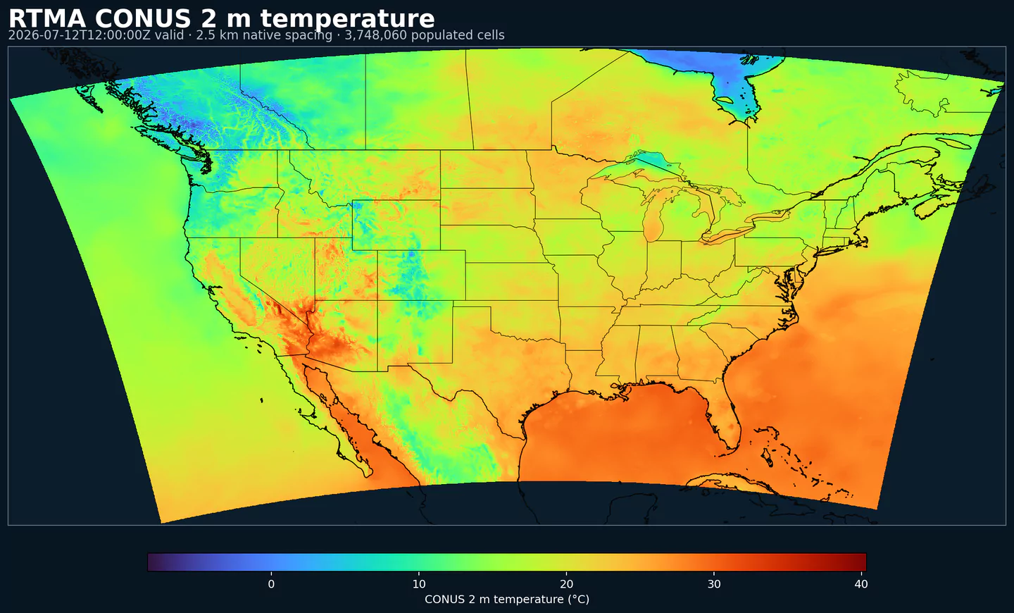
Air temperature is the thermal state of the atmosphere at the specified level. It influences density, stability, and energy exchange.
| Level | Info | Horizon | Introduced | Selector |
|---|---|---|---|---|
2 m above ground |
0h | 2017-05-01 |
{"name":"TMP","level":"2 m above ground","info":""}
|
U‑component of wind is the east‑west component of the horizontal wind. Combine with v for speed and direction.
| Level | Info | Horizon | Introduced | Selector |
|---|---|---|---|---|
10 m above ground |
0h | 2017-05-01 |
{"name":"UGRD","level":"10 m above ground","info":""}
|
V‑component of wind is the north‑south component of the horizontal wind. Combine with u for speed and direction.
| Level | Info | Horizon | Introduced | Selector |
|---|---|---|---|---|
10 m above ground |
0h | 2017-05-01 |
{"name":"VGRD","level":"10 m above ground","info":""}
|
Horizontal visibility at the surface. Lower values indicate reduced visibility due to fog, precipitation, or aerosols.
| Level | Info | Horizon | Introduced | Selector |
|---|---|---|---|---|
surface |
0h | 2017-05-01 |
{"name":"VIS","level":"surface","info":""}
|
Wind direction indicates the direction from which the wind is blowing at the specified level.
| Level | Info | Horizon | Introduced | Selector |
|---|---|---|---|---|
10 m above ground |
0h | 2017-05-01 |
{"name":"WDIR","level":"10 m above ground","info":""}
|
Wind speed is the magnitude of the horizontal wind at the specified level. It is used for transport, mixing, and hazards.
| Level | Info | Horizon | Introduced | Selector |
|---|---|---|---|---|
10 m above ground |
0h | 2017-05-01 |
{"name":"WIND","level":"10 m above ground","info":""}
|
Nessun parametro corrisponde alla ricerca.