Ceiling height is the altitude of the lowest cloud base that covers a significant portion of the sky. It is a key aviation and surface-visibility metric.
- Units: m.
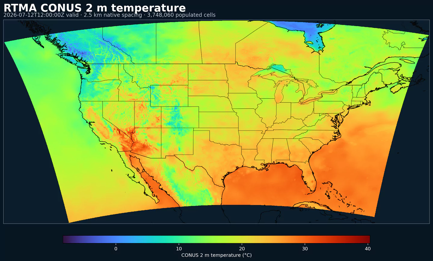
GribStream-Code: urma
URMA (Unrestricted Mesoscale Analysis) ist die stündliche hochauflösende NOAA-Analyse für Bedingungen nahe der Oberfläche. Sie dient als Referenzanalyse und führt das RTMA-System ungefähr sechs Stunden nach jeder gültigen Zeit erneut aus.
Dieser spätere Lauf kann konventionelle Beobachtungen, Mesonet-Daten, Bojen, Schiffe und radarbasierte Beobachtungen einbeziehen, die für RTMA zu spät eintreffen. Dazu gehören auch Niederschlags-QPE aus Radar-Regenmesser-Kombinationen und Schneehöhen-Updates von NOHRSC, zusammengeführt mit Methoden wie Whittaker blending.
URMA nutzt zweidimensionale Variationsassimilation (2D-Var) mit statischen Hintergrundfehlerkovarianzen im GSI-System, um Beobachtungen mit einer ersten Modellschätzung zu kombinieren. Es läuft auf mehreren Lambert-NDFD-Grids: 2.5 km für CONUS, ungefähr 3 km für Alaska und Domains für Hawaii, Puerto Rico und Guam.
Das Dataset enthält Standardfelder nahe der Oberfläche: 2-m-Temperatur, Taupunkt, spezifische Feuchte, 10-m-Wind, Oberflächendruck, Sichtweite, Wolkenuntergrenze und Niederschlag. Es integriert außerdem Offshore-Wellenhöhe und tägliche Minimal- und Maximaltemperaturen.
URMA ist wertvoll, weil es Beobachtungen und Qualitätskontrollen nutzen kann, die für den schnellen RTMA-Zyklus nicht verfügbar sind. MRMS/Multi-Radar-QPE, zusätzliche Mesonet-Netze und NOHRSC-Schneeanalysen machen es geeigneter für Verifikation und Trainingsdaten als für unmittelbares Lagebild.
Zu den dokumentierten Verbesserungen der URMA-Familie gehören der Ersatz der älteren Stage-II-Niederschlagseingabe durch MRMS/Multi-Radar-QPE und die Einbindung der NOHRSC-Schneeanalyse. In Alaska flossen URMA-Eingaben außerdem in AORC ein, um downscaling (Regionalisierung auf kleinere Skalen) für Temperatur, Feuchte, Druck und Wind zu verbessern.
Klicken Sie auf einen Parameter, um Varianten in einer kompakten Tabelle mit kopierbaren JSON-Selektoren zu sehen. Codes, Levels und Selector-Werte bleiben exakt so, wie die API sie ausgibt.
Ceiling height is the altitude of the lowest cloud base that covers a significant portion of the sky. It is a key aviation and surface-visibility metric.
| Level | Info | Horizon | Introduced | Selector |
|---|---|---|---|---|
cloud ceiling |
0h | 2017-05-01 |
{"name":"CEIL","level":"cloud ceiling","info":""}
|
Dew point temperature is the temperature at which the air becomes saturated. It is a direct measure of moisture content.
| Level | Info | Horizon | Introduced | Selector |
|---|---|---|---|---|
2 m above ground |
0h | 2017-05-01 |
{"name":"DPT","level":"2 m above ground","info":""}
|
Wind gust is the peak short-duration wind speed. It captures brief, hazardous bursts that can exceed sustained winds.
| Level | Info | Horizon | Introduced | Selector |
|---|---|---|---|---|
10 m above ground |
0h | 2017-05-01 |
{"name":"GUST","level":"10 m above ground","info":""}
|
Geopotential height is the altitude of a pressure surface in the atmosphere. It is the primary field for identifying ridges, troughs, and large‑scale flow patterns.
| Level | Info | Horizon | Introduced | Selector |
|---|---|---|---|---|
surface |
0h | 2017-05-01 |
{"name":"HGT","level":"surface","info":""}
|
Pressure is the atmospheric pressure at the specified level. It is a fundamental mass-field variable for dynamics and thermodynamics.
| Level | Info | Horizon | Introduced | Selector |
|---|---|---|---|---|
surface |
0h | 2017-05-01 |
{"name":"PRES","level":"surface","info":""}
|
Specific humidity is the mass of water vapor per mass of air at the specified level. It is central to moisture transport.
| Level | Info | Horizon | Introduced | Selector |
|---|---|---|---|---|
2 m above ground |
0h | 2017-05-01 |
{"name":"SPFH","level":"2 m above ground","info":""}
|
Air temperature is the thermal state of the atmosphere at the specified level. It influences density, stability, and energy exchange.
| Level | Info | Horizon | Introduced | Selector |
|---|---|---|---|---|
2 m above ground |
0h | 2017-05-01 |
{"name":"TMP","level":"2 m above ground","info":""}
|
U‑component of wind is the east‑west component of the horizontal wind. Combine with v for speed and direction.
| Level | Info | Horizon | Introduced | Selector |
|---|---|---|---|---|
10 m above ground |
0h | 2017-05-01 |
{"name":"UGRD","level":"10 m above ground","info":""}
|
V‑component of wind is the north‑south component of the horizontal wind. Combine with u for speed and direction.
| Level | Info | Horizon | Introduced | Selector |
|---|---|---|---|---|
10 m above ground |
0h | 2017-05-01 |
{"name":"VGRD","level":"10 m above ground","info":""}
|
Horizontal visibility at the surface. Lower values indicate reduced visibility due to fog, precipitation, or aerosols.
| Level | Info | Horizon | Introduced | Selector |
|---|---|---|---|---|
surface |
0h | 2017-05-01 |
{"name":"VIS","level":"surface","info":""}
|
Wind direction indicates the direction from which the wind is blowing at the specified level.
| Level | Info | Horizon | Introduced | Selector |
|---|---|---|---|---|
10 m above ground |
0h | 2017-05-01 |
{"name":"WDIR","level":"10 m above ground","info":""}
|
Wind speed is the magnitude of the horizontal wind at the specified level. It is used for transport, mixing, and hazards.
| Level | Info | Horizon | Introduced | Selector |
|---|---|---|---|---|
10 m above ground |
0h | 2017-05-01 |
{"name":"WIND","level":"10 m above ground","info":""}
|
Keine Parameter passen zur Suche.