Ceiling height is the altitude of the lowest cloud base that covers a significant portion of the sky. It is a key aviation and surface-visibility metric.
- Units: m.
GribStream-Code: rtma
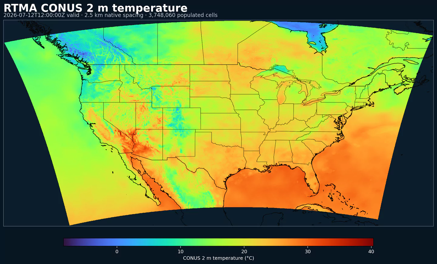
RTMA (Real-Time Mesoscale Analysis) ist die stündliche Oberflächenanalyse von NOAA/NCEP nahezu in Echtzeit. Sie soll innerhalb von etwa 30 bis 45 Minuten nach der gültigen Zeit die beste verfügbare Schätzung aktueller Wetterbedingungen liefern.
RTMA nutzt ein zweidimensionales Variationsverfahren (2D-Var), das einen kurzfristigen Modellhintergrund mit Oberflächenbeobachtungen, Mesonet-Daten, Bojen, Schiffen und radarabgeleiteten Informationen kombiniert.
Die Analyse wird auf NDFD-Grids erzeugt, einschließlich des Lambert-CONUS-Grids mit 2.5 km, sowie Domains für Alaska, Hawaii, Puerto Rico und Guam. Typische Felder sind 2-m-Temperatur, Taupunkt, 10-m-Wind, Windrichtung, Böen, Oberflächendruck, Sichtweite, Wolkenuntergrenze und Niederschlag.
RTMA ist besonders wertvoll für hochaufgelöstes Lagebild dort, wo Beobachtungen dünn sind: Küstengewässer, komplexes Gelände oder lokale Wetterwechsel mit kurzer Zeitskala.
Weil RTMA niedrige Latenz priorisiert, enthält es keine spät eintreffenden Beobachtungen. Für eine vollständigere Referenzanalyse nutzen Sie URMA, das RTMA etwa sechs Stunden später mit erweitertem Datenbestand neu ausführt.
Klicken Sie auf einen Parameter, um Varianten in einer kompakten Tabelle mit kopierbaren JSON-Selektoren zu sehen. Codes, Levels und Selector-Werte bleiben exakt so, wie die API sie ausgibt.
Ceiling height is the altitude of the lowest cloud base that covers a significant portion of the sky. It is a key aviation and surface-visibility metric.
| Level | Info | Horizon | Introduced | Selector |
|---|---|---|---|---|
cloud ceiling |
0h | 2018-01-01 |
{"name":"CEIL","level":"cloud ceiling","info":""}
|
Dew point temperature is the temperature at which the air becomes saturated. It is a direct measure of moisture content.
| Level | Info | Horizon | Introduced | Selector |
|---|---|---|---|---|
2 m above ground |
0h | 2018-01-01 |
{"name":"DPT","level":"2 m above ground","info":""}
|
Wind gust is the peak short-duration wind speed. It captures brief, hazardous bursts that can exceed sustained winds.
| Level | Info | Horizon | Introduced | Selector |
|---|---|---|---|---|
10 m above ground |
0h | 2018-01-01 |
{"name":"GUST","level":"10 m above ground","info":""}
|
Geopotential height is the altitude of a pressure surface in the atmosphere. It is the primary field for identifying ridges, troughs, and large‑scale flow patterns.
| Level | Info | Horizon | Introduced | Selector |
|---|---|---|---|---|
surface |
0h | 2018-01-01 |
{"name":"HGT","level":"surface","info":""}
|
Pressure is the atmospheric pressure at the specified level. It is a fundamental mass-field variable for dynamics and thermodynamics.
| Level | Info | Horizon | Introduced | Selector |
|---|---|---|---|---|
surface |
0h | 2018-01-01 |
{"name":"PRES","level":"surface","info":""}
|
Specific humidity is the mass of water vapor per mass of air at the specified level. It is central to moisture transport.
| Level | Info | Horizon | Introduced | Selector |
|---|---|---|---|---|
2 m above ground |
0h | 2018-01-01 |
{"name":"SPFH","level":"2 m above ground","info":""}
|
Total cloud cover is the fraction of the grid cell covered by clouds at any level. It influences radiation, temperature, and visibility.
| Level | Info | Horizon | Introduced | Selector |
|---|---|---|---|---|
entire atmosphere (considered as a single layer) |
0h | 2018-01-01 |
{"name":"TCDC","level":"entire atmosphere (considered as a single layer)","info":""}
|
Air temperature is the thermal state of the atmosphere at the specified level. It influences density, stability, and energy exchange.
| Level | Info | Horizon | Introduced | Selector |
|---|---|---|---|---|
2 m above ground |
0h | 2018-01-01 |
{"name":"TMP","level":"2 m above ground","info":""}
|
U‑component of wind is the east‑west component of the horizontal wind. Combine with v for speed and direction.
| Level | Info | Horizon | Introduced | Selector |
|---|---|---|---|---|
10 m above ground |
0h | 2018-01-01 |
{"name":"UGRD","level":"10 m above ground","info":""}
|
V‑component of wind is the north‑south component of the horizontal wind. Combine with u for speed and direction.
| Level | Info | Horizon | Introduced | Selector |
|---|---|---|---|---|
10 m above ground |
0h | 2018-01-01 |
{"name":"VGRD","level":"10 m above ground","info":""}
|
Horizontal visibility at the surface. Lower values indicate reduced visibility due to fog, precipitation, or aerosols.
| Level | Info | Horizon | Introduced | Selector |
|---|---|---|---|---|
surface |
0h | 2018-01-01 |
{"name":"VIS","level":"surface","info":""}
|
Wind direction indicates the direction from which the wind is blowing at the specified level.
| Level | Info | Horizon | Introduced | Selector |
|---|---|---|---|---|
10 m above ground |
0h | 2018-01-01 |
{"name":"WDIR","level":"10 m above ground","info":""}
|
Wind speed is the magnitude of the horizontal wind at the specified level. It is used for transport, mixing, and hazards.
| Level | Info | Horizon | Introduced | Selector |
|---|---|---|---|---|
10 m above ground |
0h | 2018-01-01 |
{"name":"WIND","level":"10 m above ground","info":""}
|
Keine Parameter passen zur Suche.