Ceiling height is the altitude of the lowest cloud base that covers a significant portion of the sky. It is a key aviation and surface-visibility metric.
- Units: m.
Código GribStream: rtma
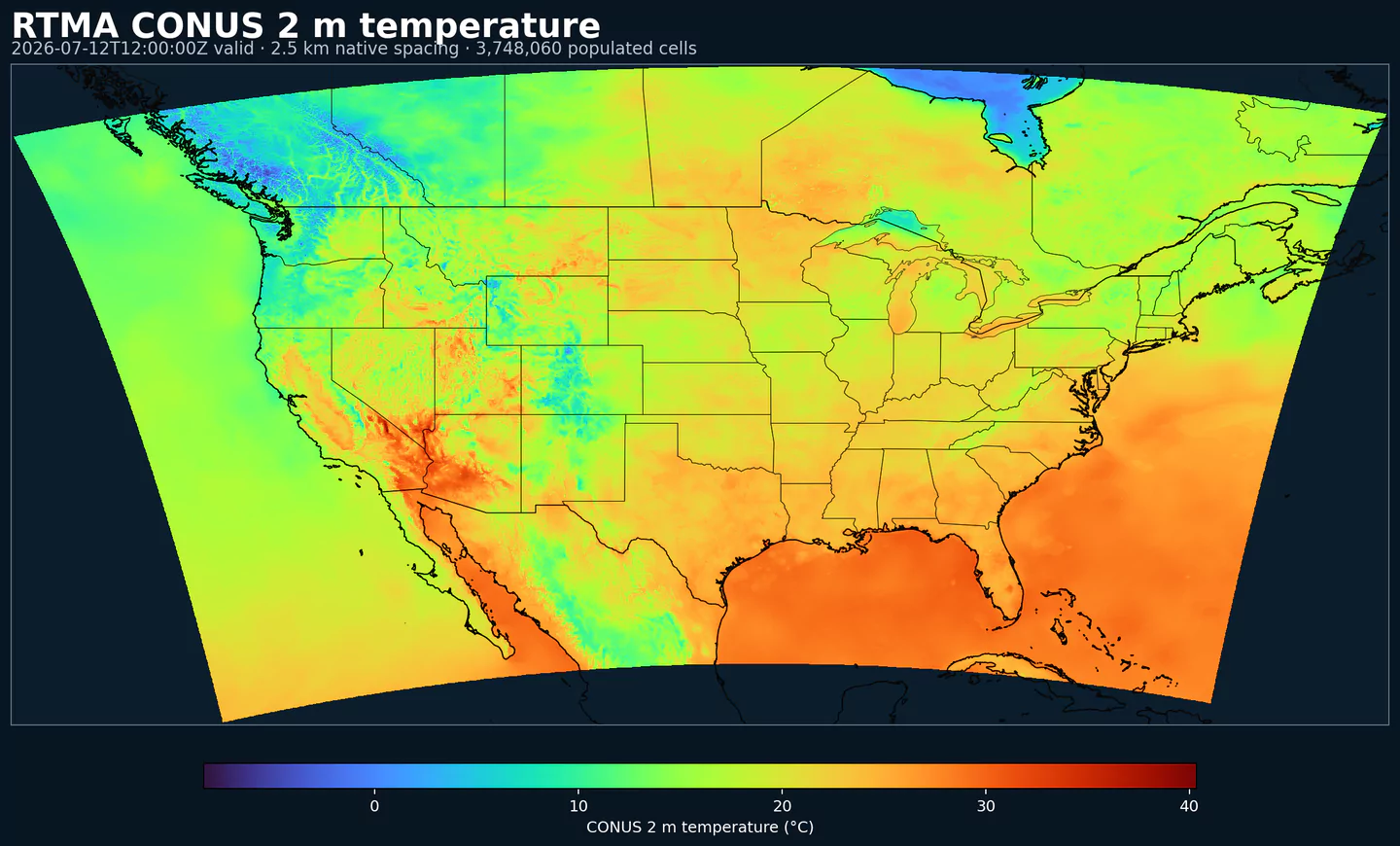
RTMA (Real-Time Mesoscale Analysis) es el análisis horario de superficie de NOAA/NCEP casi en tiempo real. Está diseñado para entregar la mejor estimación disponible de las condiciones actuales dentro de unos 30 a 45 minutos del tiempo válido.
Usa un sistema de asimilación variacional bidimensional (2D-Var) que combina un fondo de modelo de corto plazo con observaciones de superficie, mesonet, boyas, barcos y datos derivados de radar.
El análisis se genera sobre grillas NDFD, incluida la grilla Lambert CONUS de 2.5 km, además de Alaska, Hawaii, Puerto Rico y Guam. Los parámetros típicos incluyen temperatura a 2 m, punto de rocío, viento a 10 m, dirección y ráfaga, presión de superficie, visibilidad, techo de nubes y precipitación.
RTMA ayuda a mantener conciencia situacional de alta resolución donde las observaciones son escasas, por ejemplo aguas costeras, terreno complejo o zonas con cambios locales rápidos.
RTMA prioriza rapidez, por lo que no incorpora observaciones tardías. Para análisis finalizados de mayor calidad, usa URMA, que vuelve a ejecutar RTMA unas seis horas después con datos ampliados.
Haz clic en un parámetro para ver sus variantes en una tabla compacta con selectores JSON listos para copiar. Los códigos, niveles y valores de selector se mantienen exactamente como los expone la API.
Ceiling height is the altitude of the lowest cloud base that covers a significant portion of the sky. It is a key aviation and surface-visibility metric.
| Level | Info | Horizon | Introduced | Selector |
|---|---|---|---|---|
cloud ceiling |
0h | 2018-01-01 |
{"name":"CEIL","level":"cloud ceiling","info":""}
|
Dew point temperature is the temperature at which the air becomes saturated. It is a direct measure of moisture content.
| Level | Info | Horizon | Introduced | Selector |
|---|---|---|---|---|
2 m above ground |
0h | 2018-01-01 |
{"name":"DPT","level":"2 m above ground","info":""}
|
Wind gust is the peak short-duration wind speed. It captures brief, hazardous bursts that can exceed sustained winds.
| Level | Info | Horizon | Introduced | Selector |
|---|---|---|---|---|
10 m above ground |
0h | 2018-01-01 |
{"name":"GUST","level":"10 m above ground","info":""}
|
Geopotential height is the altitude of a pressure surface in the atmosphere. It is the primary field for identifying ridges, troughs, and large‑scale flow patterns.
| Level | Info | Horizon | Introduced | Selector |
|---|---|---|---|---|
surface |
0h | 2018-01-01 |
{"name":"HGT","level":"surface","info":""}
|
Pressure is the atmospheric pressure at the specified level. It is a fundamental mass-field variable for dynamics and thermodynamics.
| Level | Info | Horizon | Introduced | Selector |
|---|---|---|---|---|
surface |
0h | 2018-01-01 |
{"name":"PRES","level":"surface","info":""}
|
Specific humidity is the mass of water vapor per mass of air at the specified level. It is central to moisture transport.
| Level | Info | Horizon | Introduced | Selector |
|---|---|---|---|---|
2 m above ground |
0h | 2018-01-01 |
{"name":"SPFH","level":"2 m above ground","info":""}
|
Total cloud cover is the fraction of the grid cell covered by clouds at any level. It influences radiation, temperature, and visibility.
| Level | Info | Horizon | Introduced | Selector |
|---|---|---|---|---|
entire atmosphere (considered as a single layer) |
0h | 2018-01-01 |
{"name":"TCDC","level":"entire atmosphere (considered as a single layer)","info":""}
|
Air temperature is the thermal state of the atmosphere at the specified level. It influences density, stability, and energy exchange.
| Level | Info | Horizon | Introduced | Selector |
|---|---|---|---|---|
2 m above ground |
0h | 2018-01-01 |
{"name":"TMP","level":"2 m above ground","info":""}
|
U‑component of wind is the east‑west component of the horizontal wind. Combine with v for speed and direction.
| Level | Info | Horizon | Introduced | Selector |
|---|---|---|---|---|
10 m above ground |
0h | 2018-01-01 |
{"name":"UGRD","level":"10 m above ground","info":""}
|
V‑component of wind is the north‑south component of the horizontal wind. Combine with u for speed and direction.
| Level | Info | Horizon | Introduced | Selector |
|---|---|---|---|---|
10 m above ground |
0h | 2018-01-01 |
{"name":"VGRD","level":"10 m above ground","info":""}
|
Horizontal visibility at the surface. Lower values indicate reduced visibility due to fog, precipitation, or aerosols.
| Level | Info | Horizon | Introduced | Selector |
|---|---|---|---|---|
surface |
0h | 2018-01-01 |
{"name":"VIS","level":"surface","info":""}
|
Wind direction indicates the direction from which the wind is blowing at the specified level.
| Level | Info | Horizon | Introduced | Selector |
|---|---|---|---|---|
10 m above ground |
0h | 2018-01-01 |
{"name":"WDIR","level":"10 m above ground","info":""}
|
Wind speed is the magnitude of the horizontal wind at the specified level. It is used for transport, mixing, and hazards.
| Level | Info | Horizon | Introduced | Selector |
|---|---|---|---|---|
10 m above ground |
0h | 2018-01-01 |
{"name":"WIND","level":"10 m above ground","info":""}
|
Ningún parámetro coincide con la búsqueda.