Short-wave albedo (%).

GribStream
GribStreamコード: icond2
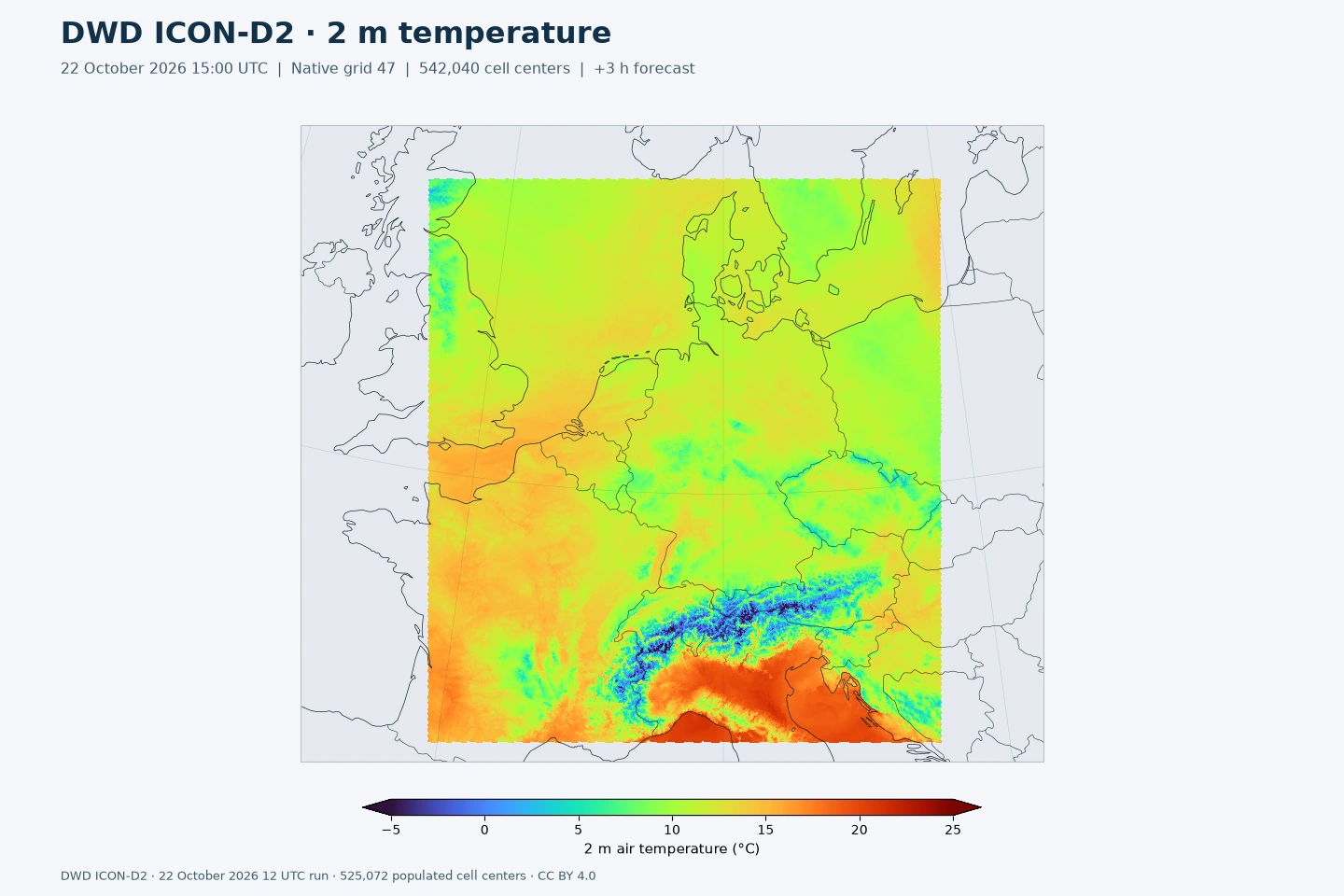
予報96項目と静的11項目を5日間保持します。従来の公開継続項目に予報34項目を追加し、積算着氷性降雨(FRZ_RAIN)、レーダー反射強度、雷雨診断などを利用できます。DWDはVISの提供を終了しました。
ライセンス: DWDはCC BY 4.0と出典表示の下でオープン地理データの商用再利用を認めています。GribStreamはDWDを作成者として示し、公式条件へリンクしています。
ICON-D2は、ドイツと中央ヨーロッパを対象とするDWDの対流許容モデルです。約2.2 kmの格子で、局地的な地形効果、対流性降水、地域の風の分布を表現します。
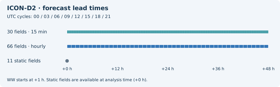
KENDAは最近の観測と短期アンサンブル予報を組み合わせて初期値を作成します。1日8回の決定論的予報は、いずれも48時間先までです。
T_2Mは気温、VMAX_10Mは突風、TOT_PRECは積算降水量、ASWDIR_Sは直達日射を提供します。FRZ_RAINは積算着氷性降雨です。降水・放射・一部の雷雨項目の15分間隔出力により、1時間内の変化を比較できます。
下の一覧からname、level、infoを選択してください。acc、ave、max、minは積算・平均・極値を表します。時系列は/api/v2/icond2/timeseries、個別の予報サイクルは/api/v2/icond2/runsで取得できます。
パラメータをクリックすると、コピーしやすいJSONセレクタ付きのコンパクトな表で候補を確認できます。コード、level、selector値はAPIが公開する値をそのまま保持します。
Short-wave albedo (%).
| Level | Info | Horizon | Introduced | Selector |
|---|---|---|---|---|
surface |
0m-48h | 5 days ago |
{"name":"ALB_RAD","level":"surface","info":""}
|
Surface latent heat flux, mean from run start (W/m^2).
| Level | Info | Horizon | Introduced | Selector |
|---|---|---|---|---|
surface |
ave |
0m-48h | 5 days ago |
{"name":"ALHFL_S","level":"surface","info":"ave"}
|
Surface photosynthetically active radiation, mean from run start (W/m^2).
| Level | Info | Horizon | Introduced | Selector |
|---|---|---|---|---|
surface |
ave |
0m-48h | 5 days ago |
{"name":"APAB_S","level":"surface","info":"ave"}
|
Surface sensible heat flux, mean from run start (W/m^2).
| Level | Info | Horizon | Introduced | Selector |
|---|---|---|---|---|
surface |
ave |
0m-48h | 5 days ago |
{"name":"ASHFL_S","level":"surface","info":"ave"}
|
Surface net short-wave radiation flux, mean from run start (W/m^2).
| Level | Info | Horizon | Introduced | Selector |
|---|---|---|---|---|
surface |
ave |
0m-48h | 5 days ago |
{"name":"ASOB_S","level":"surface","info":"ave"}
|
Top-of-atmosphere net short-wave radiation flux, mean from run start (W/m^2).
| Level | Info | Horizon | Introduced | Selector |
|---|---|---|---|---|
top of atmosphere |
ave |
0m-48h | 5 days ago |
{"name":"ASOB_T","level":"top of atmosphere","info":"ave"}
|
Surface downward diffuse short-wave radiation flux, mean from run start (W/m^2).
| Level | Info | Horizon | Introduced | Selector |
|---|---|---|---|---|
surface |
ave |
0m-48h | 5 days ago |
{"name":"ASWDIFD_S","level":"surface","info":"ave"}
|
Surface upward diffuse short-wave radiation flux, mean from run start (W/m^2).
| Level | Info | Horizon | Introduced | Selector |
|---|---|---|---|---|
surface |
ave |
0m-48h | 5 days ago |
{"name":"ASWDIFU_S","level":"surface","info":"ave"}
|
Surface downward direct short-wave radiation flux, mean from run start (W/m^2).
| Level | Info | Horizon | Introduced | Selector |
|---|---|---|---|---|
surface |
ave |
0m-48h | 5 days ago |
{"name":"ASWDIR_S","level":"surface","info":"ave"}
|
Surface net long-wave radiation flux, mean from run start (W/m^2).
| Level | Info | Horizon | Introduced | Selector |
|---|---|---|---|---|
surface |
ave |
0m-48h | 5 days ago |
{"name":"ATHB_S","level":"surface","info":"ave"}
|
Top-of-atmosphere net long-wave radiation flux, mean from run start (W/m^2).
| Level | Info | Horizon | Introduced | Selector |
|---|---|---|---|---|
top of atmosphere |
ave |
0m-48h | 5 days ago |
{"name":"ATHB_T","level":"top of atmosphere","info":"ave"}
|
Surface momentum flux U component, mean from run start (N/m^2).
| Level | Info | Horizon | Introduced | Selector |
|---|---|---|---|---|
surface |
ave |
0m-48h | 5 days ago |
{"name":"AUMFL_S","level":"surface","info":"ave"}
|
Surface momentum flux V component, mean from run start (N/m^2).
| Level | Info | Horizon | Introduced | Selector |
|---|---|---|---|---|
surface |
ave |
0m-48h | 5 days ago |
{"name":"AVMFL_S","level":"surface","info":"ave"}
|
Mean-layer convective available potential energy (J/kg).
| Level | Info | Horizon | Introduced | Selector |
|---|---|---|---|---|
local level type 192 0 |
0m-48h | 5 days ago |
{"name":"CAPE_ML","level":"local level type 192 0","info":""}
|
Ceiling height above mean sea level (m).
| Level | Info | Horizon | Introduced | Selector |
|---|---|---|---|---|
cloud base - mean sea level |
0m-48h | 5 days ago |
{"name":"CEILING","level":"cloud base - mean sea level","info":""}
|
Mean-layer convective inhibition (J/kg).
| Level | Info | Horizon | Introduced | Selector |
|---|---|---|---|---|
local level type 192 0 |
0m-48h | 5 days ago |
{"name":"CIN_ML","level":"local level type 192 0","info":""}
|
Latitude of native cell centers (degrees).
| Level | Info | Horizon | Introduced | Selector |
|---|---|---|---|---|
surface |
0m | 5 days ago |
{"name":"CLAT","level":"surface","info":""}
|
High cloud cover in the 0-400 hPa layer (%).
| Level | Info | Horizon | Introduced | Selector |
|---|---|---|---|---|
0-400 mb |
0m-48h | 5 days ago |
{"name":"CLCH","level":"0-400 mb","info":""}
|
Low cloud cover from 800 hPa to the surface (%).
| Level | Info | Horizon | Introduced | Selector |
|---|---|---|---|---|
800 mb - surface |
0m-48h | 5 days ago |
{"name":"CLCL","level":"800 mb - surface","info":""}
|
Mid-level cloud cover in the 400-800 hPa layer (%).
| Level | Info | Horizon | Introduced | Selector |
|---|---|---|---|---|
400-800 mb |
0m-48h | 5 days ago |
{"name":"CLCM","level":"400-800 mb","info":""}
|
Total cloud cover (%).
| Level | Info | Horizon | Introduced | Selector |
|---|---|---|---|---|
surface |
0m-48h | 5 days ago |
{"name":"CLCT","level":"surface","info":""}
|
Modified total cloud cover for media products (numeric).
| Level | Info | Horizon | Introduced | Selector |
|---|---|---|---|---|
surface |
0m-48h | 5 days ago |
{"name":"CLCT_MOD","level":"surface","info":""}
|
Modified cloud depth for media products (numeric).
| Level | Info | Horizon | Introduced | Selector |
|---|---|---|---|---|
surface |
0m-48h | 5 days ago |
{"name":"CLDEPTH","level":"surface","info":""}
|
Longitude of native cell centers (degrees).
| Level | Info | Horizon | Introduced | Selector |
|---|---|---|---|---|
surface |
0m | 5 days ago |
{"name":"CLON","level":"surface","info":""}
|
Lake thermocline temperature-profile shape factor (1).
| Level | Info | Horizon | Introduced | Selector |
|---|---|---|---|---|
maxing layer - lake or river bottom |
0m-48h | 5 days ago |
{"name":"C_T_LK","level":"maxing layer - lake or river bottom","info":""}
|
Radar reflectivity near 850 hPa (dBZ).
| Level | Info | Horizon | Introduced | Selector |
|---|---|---|---|---|
surface |
0m-48h | 5 days ago |
{"name":"DBZ_850","level":"surface","info":""}
|
Column maximum radar reflectivity (dBZ).
| Level | Info | Horizon | Introduced | Selector |
|---|---|---|---|---|
atmos col |
0m-48h | 5 days ago |
{"name":"DBZ_CMAX","level":"atmos col","info":""}
|
Column maximum radar reflectivity over the preceding hour (dBZ).
| Level | Info | Horizon | Introduced | Selector |
|---|---|---|---|---|
atmos col |
max |
0m-48h | 5 days ago |
{"name":"DBZ_CTMAX","level":"atmos col","info":"max"}
|
Lake depth (m).
| Level | Info | Horizon | Introduced | Selector |
|---|---|---|---|---|
surface - lake or river bottom |
0m | 5 days ago |
{"name":"DEPTH_LK","level":"surface - lake or river bottom","info":""}
|
Minimum pressure of the 18 dBZ echo top over the preceding 15 minutes (Pa).
| Level | Info | Horizon | Introduced | Selector |
|---|---|---|---|---|
highest level > 18 dBZ |
min |
0m-48h | 5 days ago |
{"name":"ECHOTOP","level":"highest level > 18 dBZ","info":"min"}
|
Fresh-snow fraction (1).
| Level | Info | Horizon | Introduced | Selector |
|---|---|---|---|---|
surface |
0m-48h | 5 days ago |
{"name":"FRESHSNW","level":"surface","info":""}
|
Freezing-rain water equivalent accumulated from run start (kg/m^2).
| Level | Info | Horizon | Introduced | Selector |
|---|---|---|---|---|
surface |
acc |
0m-48h | 5 days ago |
{"name":"FRZ_RAIN","level":"surface","info":"acc"}
|
Ice Cover (Proportion).
| Level | Info | Horizon | Introduced | Selector |
|---|---|---|---|---|
surface |
0m | 5 days ago |
{"name":"FR_ICE","level":"surface","info":""}
|
Lake area fraction (fraction (0-1)).
| Level | Info | Horizon | Introduced | Selector |
|---|---|---|---|---|
surface |
0m | 5 days ago |
{"name":"FR_LAKE","level":"surface","info":""}
|
Land area fraction (fraction (0-1)).
| Level | Info | Horizon | Introduced | Selector |
|---|---|---|---|---|
surface |
0m | 5 days ago |
{"name":"FR_LAND","level":"surface","info":""}
|
Grid-scale graupel accumulated from run start (kg/m^2).
| Level | Info | Horizon | Introduced | Selector |
|---|---|---|---|---|
surface |
acc |
0m-48h | 5 days ago |
{"name":"GRAU_GSP","level":"surface","info":"acc"}
|
Shallow-convection cloud-base height above mean sea level (m).
| Level | Info | Horizon | Introduced | Selector |
|---|---|---|---|---|
cloud base - mean sea level |
0m-48h | 5 days ago |
{"name":"HBAS_SC","level":"cloud base - mean sea level","info":""}
|
Surface geometric height above mean sea level (m).
| Level | Info | Horizon | Introduced | Selector |
|---|---|---|---|---|
surface - mean sea level |
0m | 5 days ago |
{"name":"HSURF","level":"surface - mean sea level","info":""}
|
Dry-convection top height above mean sea level (m).
| Level | Info | Horizon | Introduced | Selector |
|---|---|---|---|---|
cloud top - mean sea level |
0m-48h | 5 days ago |
{"name":"HTOP_DC","level":"cloud top - mean sea level","info":""}
|
Shallow-convection cloud-top height above mean sea level (m).
| Level | Info | Horizon | Introduced | Selector |
|---|---|---|---|---|
cloud top - mean sea level |
0m-48h | 5 days ago |
{"name":"HTOP_SC","level":"cloud top - mean sea level","info":""}
|
Height of the 0 C isotherm above mean sea level (m).
| Level | Info | Horizon | Introduced | Selector |
|---|---|---|---|---|
0C isotherm - mean sea level |
0m-48h | 5 days ago |
{"name":"HZEROCL","level":"0C isotherm - mean sea level","info":""}
|
Sea-ice thickness (m).
| Level | Info | Horizon | Introduced | Selector |
|---|---|---|---|---|
surface |
0m-48h | 5 days ago |
{"name":"H_ICE","level":"surface","info":""}
|
Lake mixed-layer depth (m).
| Level | Info | Horizon | Introduced | Selector |
|---|---|---|---|---|
surface - maxing layer |
0m-48h | 5 days ago |
{"name":"H_ML_LK","level":"surface - maxing layer","info":""}
|
Snow depth (m).
| Level | Info | Horizon | Introduced | Selector |
|---|---|---|---|---|
surface |
0m-48h | 5 days ago |
{"name":"H_SNOW","level":"surface","info":""}
|
Leaf area index (m^2/m^2).
| Level | Info | Horizon | Introduced | Selector |
|---|---|---|---|---|
surface |
0m | 5 days ago |
{"name":"LAI","level":"surface","info":""}
|
Lightning potential index (J/kg).
| Level | Info | Horizon | Introduced | Selector |
|---|---|---|---|---|
surface |
0m-48h | 5 days ago |
{"name":"LPI","level":"surface","info":""}
|
Maximum lightning potential index over the preceding hour (J/kg).
| Level | Info | Horizon | Introduced | Selector |
|---|---|---|---|---|
surface |
max |
0m-48h | 5 days ago |
{"name":"LPI_MAX","level":"surface","info":"max"}
|
Mixed-layer depth (m).
| Level | Info | Horizon | Introduced | Selector |
|---|---|---|---|---|
surface |
0m-48h | 5 days ago |
{"name":"MH","level":"surface","info":""}
|
Plant cover fraction (fraction (0-1)).
| Level | Info | Horizon | Introduced | Selector |
|---|---|---|---|---|
surface |
0m | 5 days ago |
{"name":"PLCOV","level":"surface","info":""}
|
Pressure reduced to mean sea level (Pa).
| Level | Info | Horizon | Introduced | Selector |
|---|---|---|---|---|
mean sea level |
0m-48h | 5 days ago |
{"name":"PMSL","level":"mean sea level","info":""}
|
Grid-scale graupel precipitation rate (kg/m^2/s).
| Level | Info | Horizon | Introduced | Selector |
|---|---|---|---|---|
surface |
0m-48h | 5 days ago |
{"name":"PRG_GSP","level":"surface","info":""}
|
Grid-scale rain rate (kg/m^2/s).
| Level | Info | Horizon | Introduced | Selector |
|---|---|---|---|---|
surface |
0m-48h | 5 days ago |
{"name":"PRR_GSP","level":"surface","info":""}
|
Grid-scale snowfall water-equivalent rate (kg/m^2/s).
| Level | Info | Horizon | Introduced | Selector |
|---|---|---|---|---|
surface |
0m-48h | 5 days ago |
{"name":"PRS_GSP","level":"surface","info":""}
|
Surface pressure (Pa).
| Level | Info | Horizon | Introduced | Selector |
|---|---|---|---|---|
surface |
0m-48h | 5 days ago |
{"name":"PS","level":"surface","info":""}
|
Surface specific humidity (kg/kg).
| Level | Info | Horizon | Introduced | Selector |
|---|---|---|---|---|
surface |
0m-48h | 5 days ago |
{"name":"QV_S","level":"surface","info":""}
|
Convective rainfall accumulated from run start (kg/m^2).
| Level | Info | Horizon | Introduced | Selector |
|---|---|---|---|---|
surface |
acc |
0m-48h | 5 days ago |
{"name":"RAIN_CON","level":"surface","info":"acc"}
|
Grid-scale rainfall accumulated from run start (kg/m^2).
| Level | Info | Horizon | Introduced | Selector |
|---|---|---|---|---|
surface |
acc |
0m-48h | 5 days ago |
{"name":"RAIN_GSP","level":"surface","info":"acc"}
|
2 m relative humidity (%).
| Level | Info | Horizon | Introduced | Selector |
|---|---|---|---|---|
2 m above ground |
0m-48h | 5 days ago |
{"name":"RELHUM_2M","level":"2 m above ground","info":""}
|
Snow density (kg/m^3).
| Level | Info | Horizon | Introduced | Selector |
|---|---|---|---|---|
surface |
0m-48h | 5 days ago |
{"name":"RHO_SNOW","level":"surface","info":""}
|
Root depth (m).
| Level | Info | Horizon | Introduced | Selector |
|---|---|---|---|---|
surface |
0m | 5 days ago |
{"name":"ROOTDP","level":"surface","info":""}
|
Groundwater runoff accumulated from run start (kg/m^2).
| Level | Info | Horizon | Introduced | Selector |
|---|---|---|---|---|
0.1-1 m below ground |
acc |
0m-48h | 5 days ago |
{"name":"RUNOFF_G","level":"0.1-1 m below ground","info":"acc"}
|
Surface runoff accumulated from run start (kg/m^2).
| Level | Info | Horizon | Introduced | Selector |
|---|---|---|---|---|
0-0.1 m below ground |
acc |
0m-48h | 5 days ago |
{"name":"RUNOFF_S","level":"0-0.1 m below ground","info":"acc"}
|
Supercell detection index 2 (1/s).
| Level | Info | Horizon | Introduced | Selector |
|---|---|---|---|---|
surface |
0m-48h | 5 days ago |
{"name":"SDI_2","level":"surface","info":""}
|
Snow cover (%).
| Level | Info | Horizon | Introduced | Selector |
|---|---|---|---|---|
surface |
0m-48h | 5 days ago |
{"name":"SNOWC","level":"surface","info":""}
|
Snowfall-limit height above mean sea level (m).
| Level | Info | Horizon | Introduced | Selector |
|---|---|---|---|---|
0C isotherm - mean sea level |
0m-48h | 5 days ago |
{"name":"SNOWLMT","level":"0C isotherm - mean sea level","info":""}
|
Convective snowfall water equivalent accumulated from run start (kg/m^2).
| Level | Info | Horizon | Introduced | Selector |
|---|---|---|---|---|
surface |
acc |
0m-48h | 5 days ago |
{"name":"SNOW_CON","level":"surface","info":"acc"}
|
Grid-scale snowfall water equivalent accumulated from run start (kg/m^2).
| Level | Info | Horizon | Introduced | Selector |
|---|---|---|---|---|
surface |
acc |
0m-48h | 5 days ago |
{"name":"SNOW_GSP","level":"surface","info":"acc"}
|
Soil type (code).
| Level | Info | Horizon | Introduced | Selector |
|---|---|---|---|---|
surface |
0m | 5 days ago |
{"name":"SOILTYP","level":"surface","info":""}
|
Synthetic cloudy-sky brightness temperature for Meteosat SEVIRI 10.8 micrometres (K).
| Level | Info | Horizon | Introduced | Selector |
|---|---|---|---|---|
no_level |
sat=METEOSAT 13 SEVIRI 10.80 um |
0m-48h | 5 days ago |
{"name":"SYNMSG_BT_CL_IR10.8","level":"no_level","info":"sat=METEOSAT 13 SEVIRI 10.80 um"}
|
Synthetic cloudy-sky brightness temperature for Meteosat SEVIRI 6.2 micrometres (K).
| Level | Info | Horizon | Introduced | Selector |
|---|---|---|---|---|
no_level |
sat=METEOSAT 13 SEVIRI 6.20 um |
0m-48h | 5 days ago |
{"name":"SYNMSG_BT_CL_WV6.2","level":"no_level","info":"sat=METEOSAT 13 SEVIRI 6.20 um"}
|
Turbulent transfer coefficient for heat and moisture (numeric).
| Level | Info | Horizon | Introduced | Selector |
|---|---|---|---|---|
surface |
0m-48h | 5 days ago |
{"name":"TCH","level":"surface","info":""}
|
Turbulent transfer coefficient for momentum (numeric).
| Level | Info | Horizon | Introduced | Selector |
|---|---|---|---|---|
surface |
0m-48h | 5 days ago |
{"name":"TCM","level":"surface","info":""}
|
Maximum column condensate above the -10 C level over the preceding hour (kg/m^2).
| Level | Info | Horizon | Introduced | Selector |
|---|---|---|---|---|
263.15 K level - top of atmosphere |
max |
0m-48h | 5 days ago |
{"name":"TCOND10_MX","level":"263.15 K level - top of atmosphere","info":"max"}
|
Maximum total column condensate over the preceding hour (kg/m^2).
| Level | Info | Horizon | Introduced | Selector |
|---|---|---|---|---|
atmos col |
max |
0m-48h | 5 days ago |
{"name":"TCOND_MAX","level":"atmos col","info":"max"}
|
2 m dew point temperature (K).
| Level | Info | Horizon | Introduced | Selector |
|---|---|---|---|---|
2 m above ground |
0m-48h | 5 days ago |
{"name":"TD_2M","level":"2 m above ground","info":""}
|
Maximum 2 m temperature over the source-reported interval (K).
| Level | Info | Horizon | Introduced | Selector |
|---|---|---|---|---|
2 m above ground |
max |
0m-48h | 5 days ago |
{"name":"TMAX_2M","level":"2 m above ground","info":"max"}
|
Minimum 2 m temperature over the source-reported interval (K).
| Level | Info | Horizon | Introduced | Selector |
|---|---|---|---|---|
2 m above ground |
min |
0m-48h | 5 days ago |
{"name":"TMIN_2M","level":"2 m above ground","info":"min"}
|
Total precipitation accumulated from run start (kg/m^2).
| Level | Info | Horizon | Introduced | Selector |
|---|---|---|---|---|
surface |
acc |
0m-48h | 5 days ago |
{"name":"TOT_PREC","level":"surface","info":"acc"}
|
Total column-integrated cloud water (kg/m^2).
| Level | Info | Horizon | Introduced | Selector |
|---|---|---|---|---|
surface |
0m-48h | 5 days ago |
{"name":"TQC","level":"surface","info":""}
|
Diagnostic column-integrated cloud water (kg/m^2).
| Level | Info | Horizon | Introduced | Selector |
|---|---|---|---|---|
surface |
0m-48h | 5 days ago |
{"name":"TQC_DIA","level":"surface","info":""}
|
Total column-integrated graupel (kg/m^2).
| Level | Info | Horizon | Introduced | Selector |
|---|---|---|---|---|
surface |
0m-48h | 5 days ago |
{"name":"TQG","level":"surface","info":""}
|
Total column-integrated cloud ice (kg/m^2).
| Level | Info | Horizon | Introduced | Selector |
|---|---|---|---|---|
surface |
0m-48h | 5 days ago |
{"name":"TQI","level":"surface","info":""}
|
Diagnostic column-integrated cloud ice (kg/m^2).
| Level | Info | Horizon | Introduced | Selector |
|---|---|---|---|---|
surface |
0m-48h | 5 days ago |
{"name":"TQI_DIA","level":"surface","info":""}
|
Total column-integrated rain (kg/m^2).
| Level | Info | Horizon | Introduced | Selector |
|---|---|---|---|---|
surface |
0m-48h | 5 days ago |
{"name":"TQR","level":"surface","info":""}
|
Total column-integrated snow (kg/m^2).
| Level | Info | Horizon | Introduced | Selector |
|---|---|---|---|---|
surface |
0m-48h | 5 days ago |
{"name":"TQS","level":"surface","info":""}
|
Total column-integrated water vapour (kg/m^2).
| Level | Info | Horizon | Introduced | Selector |
|---|---|---|---|---|
surface |
0m-48h | 5 days ago |
{"name":"TQV","level":"surface","info":""}
|
Diagnostic column-integrated water vapour (kg/m^2).
| Level | Info | Horizon | Introduced | Selector |
|---|---|---|---|---|
surface |
0m-48h | 5 days ago |
{"name":"TQV_DIA","level":"surface","info":""}
|
Total column-integrated water including precipitation (kg/m^2).
| Level | Info | Horizon | Introduced | Selector |
|---|---|---|---|---|
surface |
0m-48h | 5 days ago |
{"name":"TWATER","level":"surface","info":""}
|
2 m temperature (K).
| Level | Info | Horizon | Introduced | Selector |
|---|---|---|---|---|
2 m above ground |
0m-48h | 5 days ago |
{"name":"T_2M","level":"2 m above ground","info":""}
|
Lake-bottom water temperature (K).
| Level | Info | Horizon | Introduced | Selector |
|---|---|---|---|---|
lake or river bottom |
0m-48h | 5 days ago |
{"name":"T_BOT_LK","level":"lake or river bottom","info":""}
|
Ground temperature (K).
| Level | Info | Horizon | Introduced | Selector |
|---|---|---|---|---|
surface |
0m-48h | 5 days ago |
{"name":"T_G","level":"surface","info":""}
|
Sea-ice temperature (K).
| Level | Info | Horizon | Introduced | Selector |
|---|---|---|---|---|
surface |
0m-48h | 5 days ago |
{"name":"T_ICE","level":"surface","info":""}
|
Mean lake water temperature (K).
| Level | Info | Horizon | Introduced | Selector |
|---|---|---|---|---|
surface - lake or river bottom |
0m-48h | 5 days ago |
{"name":"T_MNW_LK","level":"surface - lake or river bottom","info":""}
|
Temperature at the top of the snow layer (K).
| Level | Info | Horizon | Introduced | Selector |
|---|---|---|---|---|
surface |
0m-48h | 5 days ago |
{"name":"T_SNOW","level":"surface","info":""}
|
Lake mixed-layer water temperature (K).
| Level | Info | Horizon | Introduced | Selector |
|---|---|---|---|---|
surface - maxing layer |
0m-48h | 5 days ago |
{"name":"T_WML_LK","level":"surface - maxing layer","info":""}
|
Maximum updraft helicity in the 2-8 km layer over the preceding hour (m^2/s^2).
| Level | Info | Horizon | Introduced | Selector |
|---|---|---|---|---|
2000-8000 m above mean sea level |
max |
0m-48h | 5 days ago |
{"name":"UH_MAX","level":"2000-8000 m above mean sea level","info":"max"}
|
Maximum updraft helicity in the 0-3 km layer over the preceding hour (m^2/s^2).
| Level | Info | Horizon | Introduced | Selector |
|---|---|---|---|---|
0-3000 m above mean sea level |
max |
0m-48h | 5 days ago |
{"name":"UH_MAX_LOW","level":"0-3000 m above mean sea level","info":"max"}
|
Maximum updraft helicity in the 2-5 km layer over the preceding hour (m^2/s^2).
| Level | Info | Horizon | Introduced | Selector |
|---|---|---|---|---|
2000-5000 m above mean sea level |
max |
0m-48h | 5 days ago |
{"name":"UH_MAX_MED","level":"2000-5000 m above mean sea level","info":"max"}
|
10 m U wind component (m/s).
| Level | Info | Horizon | Introduced | Selector |
|---|---|---|---|---|
10 m above ground |
0m-48h | 5 days ago |
{"name":"U_10M","level":"10 m above ground","info":""}
|
Maximum 10 m wind speed over the preceding output interval (m/s).
| Level | Info | Horizon | Introduced | Selector |
|---|---|---|---|---|
10 m above ground |
max |
0m-48h | 5 days ago |
{"name":"VMAX_10M","level":"10 m above ground","info":"max"}
|
Largest absolute vertically averaged vorticity over the preceding hour (1/s).
| Level | Info | Horizon | Introduced | Selector |
|---|---|---|---|---|
0-3000 m above mean sea level |
max |
0m-48h | 5 days ago |
{"name":"VORW_CTMAX","level":"0-3000 m above mean sea level","info":"max"}
|
10 m V wind component (m/s).
| Level | Info | Horizon | Introduced | Selector |
|---|---|---|---|---|
10 m above ground |
0m-48h | 5 days ago |
{"name":"V_10M","level":"10 m above ground","info":""}
|
Weather interpretation using WMO present-weather codes (code).
| Level | Info | Horizon | Introduced | Selector |
|---|---|---|---|---|
surface |
1h-48h | 5 days ago |
{"name":"WW","level":"surface","info":""}
|
Maximum vertical velocity in the 0-10 km layer over the preceding hour (m/s).
| Level | Info | Horizon | Introduced | Selector |
|---|---|---|---|---|
0-10000 m above mean sea level |
max |
0m-48h | 5 days ago |
{"name":"W_CTMAX","level":"0-10000 m above mean sea level","info":"max"}
|
Plant canopy surface water (kg/m^2).
| Level | Info | Horizon | Introduced | Selector |
|---|---|---|---|---|
surface |
0m-48h | 5 days ago |
{"name":"W_I","level":"surface","info":""}
|
Snow-depth water equivalent (kg/m^2).
| Level | Info | Horizon | Introduced | Selector |
|---|---|---|---|---|
surface |
0m-48h | 5 days ago |
{"name":"W_SNOW","level":"surface","info":""}
|
Surface roughness length (m).
| Level | Info | Horizon | Introduced | Selector |
|---|---|---|---|---|
surface |
0m-48h | 5 days ago |
{"name":"Z0","level":"surface","info":""}
|
検索に一致するパラメータはありません。