Short-wave albedo (%).

GribStream
Código GribStream: icond2
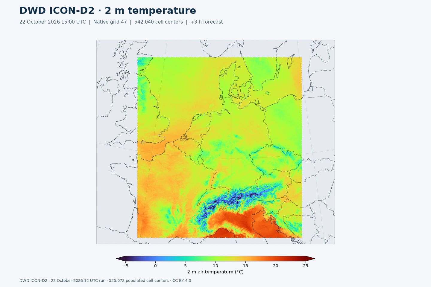
96 campos de previsão e 11 estáticos, mantidos por cinco dias. A coleção acrescenta 34 campos de previsão ao inventário anterior ainda publicado, incluindo chuva congelante acumulada (FRZ_RAIN), refletividade radar e diagnósticos de tempestades. O DWD retirou VIS.
Licença: O DWD permite reutilização comercial de seus geodados abertos sob CC BY 4.0 com atribuição. O GribStream identifica o DWD como criador e aponta para os termos oficiais.
ICON-D2 é o modelo de convecção explícita do DWD para a Alemanha e a Europa Central. Sua malha de cerca de 2,2 km representa efeitos locais do relevo, precipitação convectiva e padrões regionais de vento.
KENDA combina observações recentes com previsões curtas de ensemble para inicializar o modelo. Os oito ciclos determinísticos diários alcançam 48 horas.
T_2M fornece temperatura; VMAX_10M, rajadas; TOT_PREC, precipitação acumulada; e ASWDIR_S, radiação solar direta. FRZ_RAIN acrescenta chuva congelante acumulada. Os passos de 15 minutos de precipitação, radiação e certos campos de tempestade permitem comparações dentro de cada hora.
Escolha name, level e info no inventário. acc, ave, max e min identificam acumulações, médias e extremos. Consulte /api/v2/icond2/timeseries para séries temporais ou /api/v2/icond2/runs para ciclos individuais.
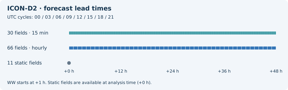
Clique em um parâmetro para ver as variantes em uma tabela compacta, com seletores JSON prontos para copiar. Códigos, níveis e valores do seletor ficam exatamente como a API expõe.
Short-wave albedo (%).
| Level | Info | Horizon | Introduced | Selector |
|---|---|---|---|---|
surface |
0m-48h | 5 days ago |
{"name":"ALB_RAD","level":"surface","info":""}
|
Surface latent heat flux, mean from run start (W/m^2).
| Level | Info | Horizon | Introduced | Selector |
|---|---|---|---|---|
surface |
ave |
0m-48h | 5 days ago |
{"name":"ALHFL_S","level":"surface","info":"ave"}
|
Surface photosynthetically active radiation, mean from run start (W/m^2).
| Level | Info | Horizon | Introduced | Selector |
|---|---|---|---|---|
surface |
ave |
0m-48h | 5 days ago |
{"name":"APAB_S","level":"surface","info":"ave"}
|
Surface sensible heat flux, mean from run start (W/m^2).
| Level | Info | Horizon | Introduced | Selector |
|---|---|---|---|---|
surface |
ave |
0m-48h | 5 days ago |
{"name":"ASHFL_S","level":"surface","info":"ave"}
|
Surface net short-wave radiation flux, mean from run start (W/m^2).
| Level | Info | Horizon | Introduced | Selector |
|---|---|---|---|---|
surface |
ave |
0m-48h | 5 days ago |
{"name":"ASOB_S","level":"surface","info":"ave"}
|
Top-of-atmosphere net short-wave radiation flux, mean from run start (W/m^2).
| Level | Info | Horizon | Introduced | Selector |
|---|---|---|---|---|
top of atmosphere |
ave |
0m-48h | 5 days ago |
{"name":"ASOB_T","level":"top of atmosphere","info":"ave"}
|
Surface downward diffuse short-wave radiation flux, mean from run start (W/m^2).
| Level | Info | Horizon | Introduced | Selector |
|---|---|---|---|---|
surface |
ave |
0m-48h | 5 days ago |
{"name":"ASWDIFD_S","level":"surface","info":"ave"}
|
Surface upward diffuse short-wave radiation flux, mean from run start (W/m^2).
| Level | Info | Horizon | Introduced | Selector |
|---|---|---|---|---|
surface |
ave |
0m-48h | 5 days ago |
{"name":"ASWDIFU_S","level":"surface","info":"ave"}
|
Surface downward direct short-wave radiation flux, mean from run start (W/m^2).
| Level | Info | Horizon | Introduced | Selector |
|---|---|---|---|---|
surface |
ave |
0m-48h | 5 days ago |
{"name":"ASWDIR_S","level":"surface","info":"ave"}
|
Surface net long-wave radiation flux, mean from run start (W/m^2).
| Level | Info | Horizon | Introduced | Selector |
|---|---|---|---|---|
surface |
ave |
0m-48h | 5 days ago |
{"name":"ATHB_S","level":"surface","info":"ave"}
|
Top-of-atmosphere net long-wave radiation flux, mean from run start (W/m^2).
| Level | Info | Horizon | Introduced | Selector |
|---|---|---|---|---|
top of atmosphere |
ave |
0m-48h | 5 days ago |
{"name":"ATHB_T","level":"top of atmosphere","info":"ave"}
|
Surface momentum flux U component, mean from run start (N/m^2).
| Level | Info | Horizon | Introduced | Selector |
|---|---|---|---|---|
surface |
ave |
0m-48h | 5 days ago |
{"name":"AUMFL_S","level":"surface","info":"ave"}
|
Surface momentum flux V component, mean from run start (N/m^2).
| Level | Info | Horizon | Introduced | Selector |
|---|---|---|---|---|
surface |
ave |
0m-48h | 5 days ago |
{"name":"AVMFL_S","level":"surface","info":"ave"}
|
Mean-layer convective available potential energy (J/kg).
| Level | Info | Horizon | Introduced | Selector |
|---|---|---|---|---|
local level type 192 0 |
0m-48h | 5 days ago |
{"name":"CAPE_ML","level":"local level type 192 0","info":""}
|
Ceiling height above mean sea level (m).
| Level | Info | Horizon | Introduced | Selector |
|---|---|---|---|---|
cloud base - mean sea level |
0m-48h | 5 days ago |
{"name":"CEILING","level":"cloud base - mean sea level","info":""}
|
Mean-layer convective inhibition (J/kg).
| Level | Info | Horizon | Introduced | Selector |
|---|---|---|---|---|
local level type 192 0 |
0m-48h | 5 days ago |
{"name":"CIN_ML","level":"local level type 192 0","info":""}
|
Latitude of native cell centers (degrees).
| Level | Info | Horizon | Introduced | Selector |
|---|---|---|---|---|
surface |
0m | 5 days ago |
{"name":"CLAT","level":"surface","info":""}
|
High cloud cover in the 0-400 hPa layer (%).
| Level | Info | Horizon | Introduced | Selector |
|---|---|---|---|---|
0-400 mb |
0m-48h | 5 days ago |
{"name":"CLCH","level":"0-400 mb","info":""}
|
Low cloud cover from 800 hPa to the surface (%).
| Level | Info | Horizon | Introduced | Selector |
|---|---|---|---|---|
800 mb - surface |
0m-48h | 5 days ago |
{"name":"CLCL","level":"800 mb - surface","info":""}
|
Mid-level cloud cover in the 400-800 hPa layer (%).
| Level | Info | Horizon | Introduced | Selector |
|---|---|---|---|---|
400-800 mb |
0m-48h | 5 days ago |
{"name":"CLCM","level":"400-800 mb","info":""}
|
Total cloud cover (%).
| Level | Info | Horizon | Introduced | Selector |
|---|---|---|---|---|
surface |
0m-48h | 5 days ago |
{"name":"CLCT","level":"surface","info":""}
|
Modified total cloud cover for media products (numeric).
| Level | Info | Horizon | Introduced | Selector |
|---|---|---|---|---|
surface |
0m-48h | 5 days ago |
{"name":"CLCT_MOD","level":"surface","info":""}
|
Modified cloud depth for media products (numeric).
| Level | Info | Horizon | Introduced | Selector |
|---|---|---|---|---|
surface |
0m-48h | 5 days ago |
{"name":"CLDEPTH","level":"surface","info":""}
|
Longitude of native cell centers (degrees).
| Level | Info | Horizon | Introduced | Selector |
|---|---|---|---|---|
surface |
0m | 5 days ago |
{"name":"CLON","level":"surface","info":""}
|
Lake thermocline temperature-profile shape factor (1).
| Level | Info | Horizon | Introduced | Selector |
|---|---|---|---|---|
maxing layer - lake or river bottom |
0m-48h | 5 days ago |
{"name":"C_T_LK","level":"maxing layer - lake or river bottom","info":""}
|
Radar reflectivity near 850 hPa (dBZ).
| Level | Info | Horizon | Introduced | Selector |
|---|---|---|---|---|
surface |
0m-48h | 5 days ago |
{"name":"DBZ_850","level":"surface","info":""}
|
Column maximum radar reflectivity (dBZ).
| Level | Info | Horizon | Introduced | Selector |
|---|---|---|---|---|
atmos col |
0m-48h | 5 days ago |
{"name":"DBZ_CMAX","level":"atmos col","info":""}
|
Column maximum radar reflectivity over the preceding hour (dBZ).
| Level | Info | Horizon | Introduced | Selector |
|---|---|---|---|---|
atmos col |
max |
0m-48h | 5 days ago |
{"name":"DBZ_CTMAX","level":"atmos col","info":"max"}
|
Lake depth (m).
| Level | Info | Horizon | Introduced | Selector |
|---|---|---|---|---|
surface - lake or river bottom |
0m | 5 days ago |
{"name":"DEPTH_LK","level":"surface - lake or river bottom","info":""}
|
Minimum pressure of the 18 dBZ echo top over the preceding 15 minutes (Pa).
| Level | Info | Horizon | Introduced | Selector |
|---|---|---|---|---|
highest level > 18 dBZ |
min |
0m-48h | 5 days ago |
{"name":"ECHOTOP","level":"highest level > 18 dBZ","info":"min"}
|
Fresh-snow fraction (1).
| Level | Info | Horizon | Introduced | Selector |
|---|---|---|---|---|
surface |
0m-48h | 5 days ago |
{"name":"FRESHSNW","level":"surface","info":""}
|
Freezing-rain water equivalent accumulated from run start (kg/m^2).
| Level | Info | Horizon | Introduced | Selector |
|---|---|---|---|---|
surface |
acc |
0m-48h | 5 days ago |
{"name":"FRZ_RAIN","level":"surface","info":"acc"}
|
Ice Cover (Proportion).
| Level | Info | Horizon | Introduced | Selector |
|---|---|---|---|---|
surface |
0m | 5 days ago |
{"name":"FR_ICE","level":"surface","info":""}
|
Lake area fraction (fraction (0-1)).
| Level | Info | Horizon | Introduced | Selector |
|---|---|---|---|---|
surface |
0m | 5 days ago |
{"name":"FR_LAKE","level":"surface","info":""}
|
Land area fraction (fraction (0-1)).
| Level | Info | Horizon | Introduced | Selector |
|---|---|---|---|---|
surface |
0m | 5 days ago |
{"name":"FR_LAND","level":"surface","info":""}
|
Grid-scale graupel accumulated from run start (kg/m^2).
| Level | Info | Horizon | Introduced | Selector |
|---|---|---|---|---|
surface |
acc |
0m-48h | 5 days ago |
{"name":"GRAU_GSP","level":"surface","info":"acc"}
|
Shallow-convection cloud-base height above mean sea level (m).
| Level | Info | Horizon | Introduced | Selector |
|---|---|---|---|---|
cloud base - mean sea level |
0m-48h | 5 days ago |
{"name":"HBAS_SC","level":"cloud base - mean sea level","info":""}
|
Surface geometric height above mean sea level (m).
| Level | Info | Horizon | Introduced | Selector |
|---|---|---|---|---|
surface - mean sea level |
0m | 5 days ago |
{"name":"HSURF","level":"surface - mean sea level","info":""}
|
Dry-convection top height above mean sea level (m).
| Level | Info | Horizon | Introduced | Selector |
|---|---|---|---|---|
cloud top - mean sea level |
0m-48h | 5 days ago |
{"name":"HTOP_DC","level":"cloud top - mean sea level","info":""}
|
Shallow-convection cloud-top height above mean sea level (m).
| Level | Info | Horizon | Introduced | Selector |
|---|---|---|---|---|
cloud top - mean sea level |
0m-48h | 5 days ago |
{"name":"HTOP_SC","level":"cloud top - mean sea level","info":""}
|
Height of the 0 C isotherm above mean sea level (m).
| Level | Info | Horizon | Introduced | Selector |
|---|---|---|---|---|
0C isotherm - mean sea level |
0m-48h | 5 days ago |
{"name":"HZEROCL","level":"0C isotherm - mean sea level","info":""}
|
Sea-ice thickness (m).
| Level | Info | Horizon | Introduced | Selector |
|---|---|---|---|---|
surface |
0m-48h | 5 days ago |
{"name":"H_ICE","level":"surface","info":""}
|
Lake mixed-layer depth (m).
| Level | Info | Horizon | Introduced | Selector |
|---|---|---|---|---|
surface - maxing layer |
0m-48h | 5 days ago |
{"name":"H_ML_LK","level":"surface - maxing layer","info":""}
|
Snow depth (m).
| Level | Info | Horizon | Introduced | Selector |
|---|---|---|---|---|
surface |
0m-48h | 5 days ago |
{"name":"H_SNOW","level":"surface","info":""}
|
Leaf area index (m^2/m^2).
| Level | Info | Horizon | Introduced | Selector |
|---|---|---|---|---|
surface |
0m | 5 days ago |
{"name":"LAI","level":"surface","info":""}
|
Lightning potential index (J/kg).
| Level | Info | Horizon | Introduced | Selector |
|---|---|---|---|---|
surface |
0m-48h | 5 days ago |
{"name":"LPI","level":"surface","info":""}
|
Maximum lightning potential index over the preceding hour (J/kg).
| Level | Info | Horizon | Introduced | Selector |
|---|---|---|---|---|
surface |
max |
0m-48h | 5 days ago |
{"name":"LPI_MAX","level":"surface","info":"max"}
|
Mixed-layer depth (m).
| Level | Info | Horizon | Introduced | Selector |
|---|---|---|---|---|
surface |
0m-48h | 5 days ago |
{"name":"MH","level":"surface","info":""}
|
Plant cover fraction (fraction (0-1)).
| Level | Info | Horizon | Introduced | Selector |
|---|---|---|---|---|
surface |
0m | 5 days ago |
{"name":"PLCOV","level":"surface","info":""}
|
Pressure reduced to mean sea level (Pa).
| Level | Info | Horizon | Introduced | Selector |
|---|---|---|---|---|
mean sea level |
0m-48h | 5 days ago |
{"name":"PMSL","level":"mean sea level","info":""}
|
Grid-scale graupel precipitation rate (kg/m^2/s).
| Level | Info | Horizon | Introduced | Selector |
|---|---|---|---|---|
surface |
0m-48h | 5 days ago |
{"name":"PRG_GSP","level":"surface","info":""}
|
Grid-scale rain rate (kg/m^2/s).
| Level | Info | Horizon | Introduced | Selector |
|---|---|---|---|---|
surface |
0m-48h | 5 days ago |
{"name":"PRR_GSP","level":"surface","info":""}
|
Grid-scale snowfall water-equivalent rate (kg/m^2/s).
| Level | Info | Horizon | Introduced | Selector |
|---|---|---|---|---|
surface |
0m-48h | 5 days ago |
{"name":"PRS_GSP","level":"surface","info":""}
|
Surface pressure (Pa).
| Level | Info | Horizon | Introduced | Selector |
|---|---|---|---|---|
surface |
0m-48h | 5 days ago |
{"name":"PS","level":"surface","info":""}
|
Surface specific humidity (kg/kg).
| Level | Info | Horizon | Introduced | Selector |
|---|---|---|---|---|
surface |
0m-48h | 5 days ago |
{"name":"QV_S","level":"surface","info":""}
|
Convective rainfall accumulated from run start (kg/m^2).
| Level | Info | Horizon | Introduced | Selector |
|---|---|---|---|---|
surface |
acc |
0m-48h | 5 days ago |
{"name":"RAIN_CON","level":"surface","info":"acc"}
|
Grid-scale rainfall accumulated from run start (kg/m^2).
| Level | Info | Horizon | Introduced | Selector |
|---|---|---|---|---|
surface |
acc |
0m-48h | 5 days ago |
{"name":"RAIN_GSP","level":"surface","info":"acc"}
|
2 m relative humidity (%).
| Level | Info | Horizon | Introduced | Selector |
|---|---|---|---|---|
2 m above ground |
0m-48h | 5 days ago |
{"name":"RELHUM_2M","level":"2 m above ground","info":""}
|
Snow density (kg/m^3).
| Level | Info | Horizon | Introduced | Selector |
|---|---|---|---|---|
surface |
0m-48h | 5 days ago |
{"name":"RHO_SNOW","level":"surface","info":""}
|
Root depth (m).
| Level | Info | Horizon | Introduced | Selector |
|---|---|---|---|---|
surface |
0m | 5 days ago |
{"name":"ROOTDP","level":"surface","info":""}
|
Groundwater runoff accumulated from run start (kg/m^2).
| Level | Info | Horizon | Introduced | Selector |
|---|---|---|---|---|
0.1-1 m below ground |
acc |
0m-48h | 5 days ago |
{"name":"RUNOFF_G","level":"0.1-1 m below ground","info":"acc"}
|
Surface runoff accumulated from run start (kg/m^2).
| Level | Info | Horizon | Introduced | Selector |
|---|---|---|---|---|
0-0.1 m below ground |
acc |
0m-48h | 5 days ago |
{"name":"RUNOFF_S","level":"0-0.1 m below ground","info":"acc"}
|
Supercell detection index 2 (1/s).
| Level | Info | Horizon | Introduced | Selector |
|---|---|---|---|---|
surface |
0m-48h | 5 days ago |
{"name":"SDI_2","level":"surface","info":""}
|
Snow cover (%).
| Level | Info | Horizon | Introduced | Selector |
|---|---|---|---|---|
surface |
0m-48h | 5 days ago |
{"name":"SNOWC","level":"surface","info":""}
|
Snowfall-limit height above mean sea level (m).
| Level | Info | Horizon | Introduced | Selector |
|---|---|---|---|---|
0C isotherm - mean sea level |
0m-48h | 5 days ago |
{"name":"SNOWLMT","level":"0C isotherm - mean sea level","info":""}
|
Convective snowfall water equivalent accumulated from run start (kg/m^2).
| Level | Info | Horizon | Introduced | Selector |
|---|---|---|---|---|
surface |
acc |
0m-48h | 5 days ago |
{"name":"SNOW_CON","level":"surface","info":"acc"}
|
Grid-scale snowfall water equivalent accumulated from run start (kg/m^2).
| Level | Info | Horizon | Introduced | Selector |
|---|---|---|---|---|
surface |
acc |
0m-48h | 5 days ago |
{"name":"SNOW_GSP","level":"surface","info":"acc"}
|
Soil type (code).
| Level | Info | Horizon | Introduced | Selector |
|---|---|---|---|---|
surface |
0m | 5 days ago |
{"name":"SOILTYP","level":"surface","info":""}
|
Synthetic cloudy-sky brightness temperature for Meteosat SEVIRI 10.8 micrometres (K).
| Level | Info | Horizon | Introduced | Selector |
|---|---|---|---|---|
no_level |
sat=METEOSAT 13 SEVIRI 10.80 um |
0m-48h | 5 days ago |
{"name":"SYNMSG_BT_CL_IR10.8","level":"no_level","info":"sat=METEOSAT 13 SEVIRI 10.80 um"}
|
Synthetic cloudy-sky brightness temperature for Meteosat SEVIRI 6.2 micrometres (K).
| Level | Info | Horizon | Introduced | Selector |
|---|---|---|---|---|
no_level |
sat=METEOSAT 13 SEVIRI 6.20 um |
0m-48h | 5 days ago |
{"name":"SYNMSG_BT_CL_WV6.2","level":"no_level","info":"sat=METEOSAT 13 SEVIRI 6.20 um"}
|
Turbulent transfer coefficient for heat and moisture (numeric).
| Level | Info | Horizon | Introduced | Selector |
|---|---|---|---|---|
surface |
0m-48h | 5 days ago |
{"name":"TCH","level":"surface","info":""}
|
Turbulent transfer coefficient for momentum (numeric).
| Level | Info | Horizon | Introduced | Selector |
|---|---|---|---|---|
surface |
0m-48h | 5 days ago |
{"name":"TCM","level":"surface","info":""}
|
Maximum column condensate above the -10 C level over the preceding hour (kg/m^2).
| Level | Info | Horizon | Introduced | Selector |
|---|---|---|---|---|
263.15 K level - top of atmosphere |
max |
0m-48h | 5 days ago |
{"name":"TCOND10_MX","level":"263.15 K level - top of atmosphere","info":"max"}
|
Maximum total column condensate over the preceding hour (kg/m^2).
| Level | Info | Horizon | Introduced | Selector |
|---|---|---|---|---|
atmos col |
max |
0m-48h | 5 days ago |
{"name":"TCOND_MAX","level":"atmos col","info":"max"}
|
2 m dew point temperature (K).
| Level | Info | Horizon | Introduced | Selector |
|---|---|---|---|---|
2 m above ground |
0m-48h | 5 days ago |
{"name":"TD_2M","level":"2 m above ground","info":""}
|
Maximum 2 m temperature over the source-reported interval (K).
| Level | Info | Horizon | Introduced | Selector |
|---|---|---|---|---|
2 m above ground |
max |
0m-48h | 5 days ago |
{"name":"TMAX_2M","level":"2 m above ground","info":"max"}
|
Minimum 2 m temperature over the source-reported interval (K).
| Level | Info | Horizon | Introduced | Selector |
|---|---|---|---|---|
2 m above ground |
min |
0m-48h | 5 days ago |
{"name":"TMIN_2M","level":"2 m above ground","info":"min"}
|
Total precipitation accumulated from run start (kg/m^2).
| Level | Info | Horizon | Introduced | Selector |
|---|---|---|---|---|
surface |
acc |
0m-48h | 5 days ago |
{"name":"TOT_PREC","level":"surface","info":"acc"}
|
Total column-integrated cloud water (kg/m^2).
| Level | Info | Horizon | Introduced | Selector |
|---|---|---|---|---|
surface |
0m-48h | 5 days ago |
{"name":"TQC","level":"surface","info":""}
|
Diagnostic column-integrated cloud water (kg/m^2).
| Level | Info | Horizon | Introduced | Selector |
|---|---|---|---|---|
surface |
0m-48h | 5 days ago |
{"name":"TQC_DIA","level":"surface","info":""}
|
Total column-integrated graupel (kg/m^2).
| Level | Info | Horizon | Introduced | Selector |
|---|---|---|---|---|
surface |
0m-48h | 5 days ago |
{"name":"TQG","level":"surface","info":""}
|
Total column-integrated cloud ice (kg/m^2).
| Level | Info | Horizon | Introduced | Selector |
|---|---|---|---|---|
surface |
0m-48h | 5 days ago |
{"name":"TQI","level":"surface","info":""}
|
Diagnostic column-integrated cloud ice (kg/m^2).
| Level | Info | Horizon | Introduced | Selector |
|---|---|---|---|---|
surface |
0m-48h | 5 days ago |
{"name":"TQI_DIA","level":"surface","info":""}
|
Total column-integrated rain (kg/m^2).
| Level | Info | Horizon | Introduced | Selector |
|---|---|---|---|---|
surface |
0m-48h | 5 days ago |
{"name":"TQR","level":"surface","info":""}
|
Total column-integrated snow (kg/m^2).
| Level | Info | Horizon | Introduced | Selector |
|---|---|---|---|---|
surface |
0m-48h | 5 days ago |
{"name":"TQS","level":"surface","info":""}
|
Total column-integrated water vapour (kg/m^2).
| Level | Info | Horizon | Introduced | Selector |
|---|---|---|---|---|
surface |
0m-48h | 5 days ago |
{"name":"TQV","level":"surface","info":""}
|
Diagnostic column-integrated water vapour (kg/m^2).
| Level | Info | Horizon | Introduced | Selector |
|---|---|---|---|---|
surface |
0m-48h | 5 days ago |
{"name":"TQV_DIA","level":"surface","info":""}
|
Total column-integrated water including precipitation (kg/m^2).
| Level | Info | Horizon | Introduced | Selector |
|---|---|---|---|---|
surface |
0m-48h | 5 days ago |
{"name":"TWATER","level":"surface","info":""}
|
2 m temperature (K).
| Level | Info | Horizon | Introduced | Selector |
|---|---|---|---|---|
2 m above ground |
0m-48h | 5 days ago |
{"name":"T_2M","level":"2 m above ground","info":""}
|
Lake-bottom water temperature (K).
| Level | Info | Horizon | Introduced | Selector |
|---|---|---|---|---|
lake or river bottom |
0m-48h | 5 days ago |
{"name":"T_BOT_LK","level":"lake or river bottom","info":""}
|
Ground temperature (K).
| Level | Info | Horizon | Introduced | Selector |
|---|---|---|---|---|
surface |
0m-48h | 5 days ago |
{"name":"T_G","level":"surface","info":""}
|
Sea-ice temperature (K).
| Level | Info | Horizon | Introduced | Selector |
|---|---|---|---|---|
surface |
0m-48h | 5 days ago |
{"name":"T_ICE","level":"surface","info":""}
|
Mean lake water temperature (K).
| Level | Info | Horizon | Introduced | Selector |
|---|---|---|---|---|
surface - lake or river bottom |
0m-48h | 5 days ago |
{"name":"T_MNW_LK","level":"surface - lake or river bottom","info":""}
|
Temperature at the top of the snow layer (K).
| Level | Info | Horizon | Introduced | Selector |
|---|---|---|---|---|
surface |
0m-48h | 5 days ago |
{"name":"T_SNOW","level":"surface","info":""}
|
Lake mixed-layer water temperature (K).
| Level | Info | Horizon | Introduced | Selector |
|---|---|---|---|---|
surface - maxing layer |
0m-48h | 5 days ago |
{"name":"T_WML_LK","level":"surface - maxing layer","info":""}
|
Maximum updraft helicity in the 2-8 km layer over the preceding hour (m^2/s^2).
| Level | Info | Horizon | Introduced | Selector |
|---|---|---|---|---|
2000-8000 m above mean sea level |
max |
0m-48h | 5 days ago |
{"name":"UH_MAX","level":"2000-8000 m above mean sea level","info":"max"}
|
Maximum updraft helicity in the 0-3 km layer over the preceding hour (m^2/s^2).
| Level | Info | Horizon | Introduced | Selector |
|---|---|---|---|---|
0-3000 m above mean sea level |
max |
0m-48h | 5 days ago |
{"name":"UH_MAX_LOW","level":"0-3000 m above mean sea level","info":"max"}
|
Maximum updraft helicity in the 2-5 km layer over the preceding hour (m^2/s^2).
| Level | Info | Horizon | Introduced | Selector |
|---|---|---|---|---|
2000-5000 m above mean sea level |
max |
0m-48h | 5 days ago |
{"name":"UH_MAX_MED","level":"2000-5000 m above mean sea level","info":"max"}
|
10 m U wind component (m/s).
| Level | Info | Horizon | Introduced | Selector |
|---|---|---|---|---|
10 m above ground |
0m-48h | 5 days ago |
{"name":"U_10M","level":"10 m above ground","info":""}
|
Maximum 10 m wind speed over the preceding output interval (m/s).
| Level | Info | Horizon | Introduced | Selector |
|---|---|---|---|---|
10 m above ground |
max |
0m-48h | 5 days ago |
{"name":"VMAX_10M","level":"10 m above ground","info":"max"}
|
Largest absolute vertically averaged vorticity over the preceding hour (1/s).
| Level | Info | Horizon | Introduced | Selector |
|---|---|---|---|---|
0-3000 m above mean sea level |
max |
0m-48h | 5 days ago |
{"name":"VORW_CTMAX","level":"0-3000 m above mean sea level","info":"max"}
|
10 m V wind component (m/s).
| Level | Info | Horizon | Introduced | Selector |
|---|---|---|---|---|
10 m above ground |
0m-48h | 5 days ago |
{"name":"V_10M","level":"10 m above ground","info":""}
|
Weather interpretation using WMO present-weather codes (code).
| Level | Info | Horizon | Introduced | Selector |
|---|---|---|---|---|
surface |
1h-48h | 5 days ago |
{"name":"WW","level":"surface","info":""}
|
Maximum vertical velocity in the 0-10 km layer over the preceding hour (m/s).
| Level | Info | Horizon | Introduced | Selector |
|---|---|---|---|---|
0-10000 m above mean sea level |
max |
0m-48h | 5 days ago |
{"name":"W_CTMAX","level":"0-10000 m above mean sea level","info":"max"}
|
Plant canopy surface water (kg/m^2).
| Level | Info | Horizon | Introduced | Selector |
|---|---|---|---|---|
surface |
0m-48h | 5 days ago |
{"name":"W_I","level":"surface","info":""}
|
Snow-depth water equivalent (kg/m^2).
| Level | Info | Horizon | Introduced | Selector |
|---|---|---|---|---|
surface |
0m-48h | 5 days ago |
{"name":"W_SNOW","level":"surface","info":""}
|
Surface roughness length (m).
| Level | Info | Horizon | Introduced | Selector |
|---|---|---|---|---|
surface |
0m-48h | 5 days ago |
{"name":"Z0","level":"surface","info":""}
|
Nenhum parâmetro corresponde à busca.