Short-wave albedo (%).

GribStream
Code GribStream: icond2
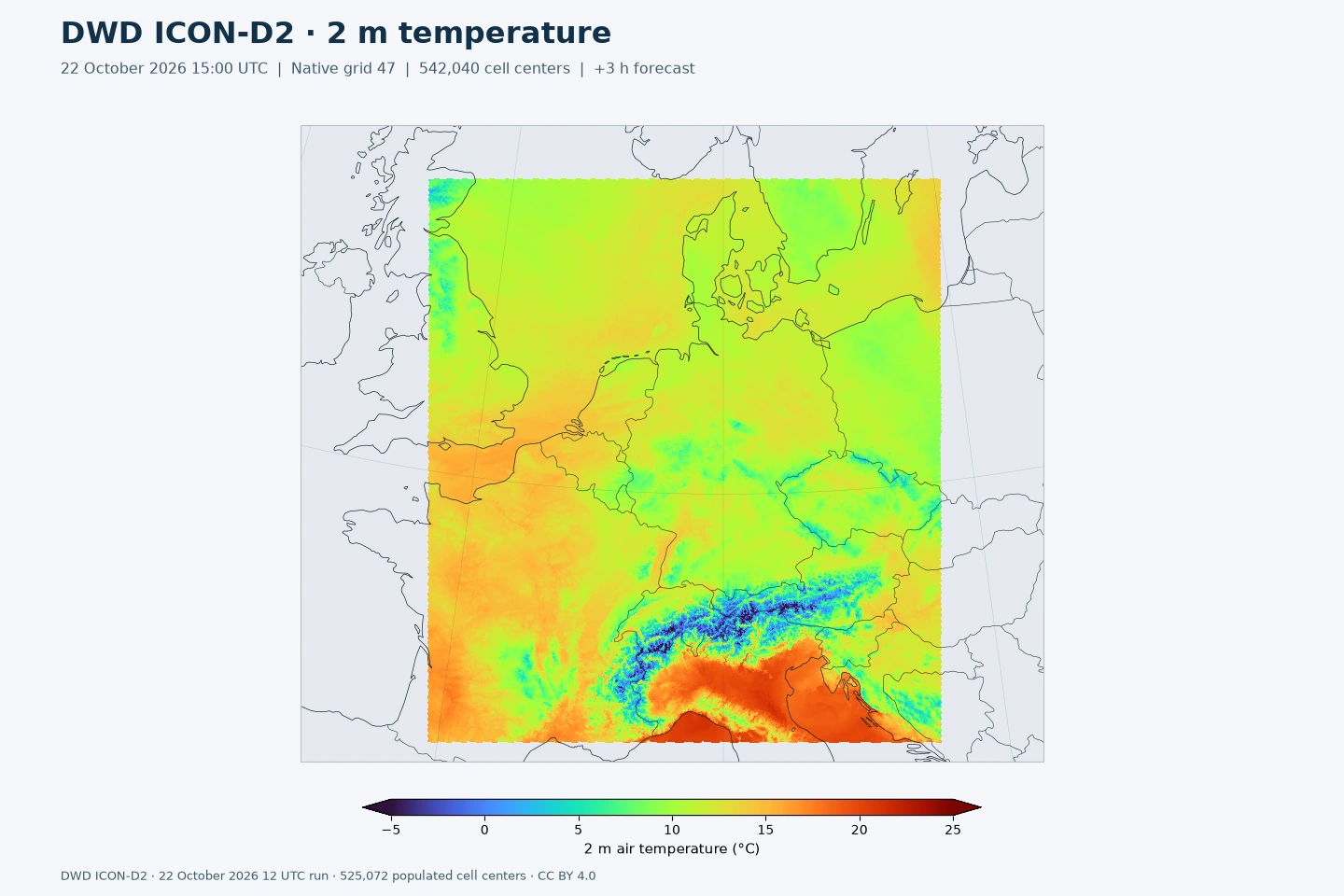
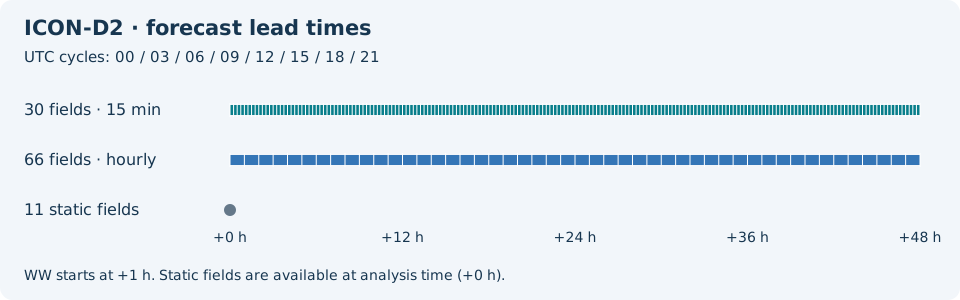
96 champs de prévision et 11 champs statiques, conservés cinq jours. La collection ajoute 34 champs de prévision à l’inventaire précédent toujours publié, dont la pluie verglaçante cumulée (FRZ_RAIN), la réflectivité radar et des diagnostics orageux. DWD a retiré VIS.
Licence : DWD autorise la réutilisation commerciale de ses géodonnées ouvertes sous CC BY 4.0 avec attribution. GribStream indique DWD comme créateur et renvoie vers les conditions officielles.
ICON-D2 est le modèle à convection explicite de DWD pour l’Allemagne et l’Europe centrale. Son maillage d’environ 2,2 km représente les effets locaux du relief, les précipitations convectives et les vents régionaux.
KENDA combine observations récentes et courtes prévisions d’ensemble pour initialiser le modèle. Les huit cycles déterministes quotidiens couvrent 48 heures.
T_2M donne la température, VMAX_10M les rafales, TOT_PREC les précipitations cumulées et ASWDIR_S le rayonnement solaire direct. FRZ_RAIN ajoute la pluie verglaçante cumulée. Les pas de 15 minutes des précipitations, du rayonnement et de certains diagnostics orageux permettent des comparaisons au sein de chaque heure.
Choisissez name, level et info dans l’inventaire. Les valeurs acc, ave, max et min identifient cumuls, moyennes et extrêmes. Utilisez /api/v2/icond2/timeseries pour les séries temporelles ou /api/v2/icond2/runs pour les cycles individuels.
Cliquez sur un paramètre pour voir ses variantes dans une table compacte avec des sélecteurs JSON prêts à copier. Les codes, niveaux et valeurs de sélecteur restent exactement tels que l'API les expose.
Short-wave albedo (%).
| Level | Info | Horizon | Introduced | Selector |
|---|---|---|---|---|
surface |
0m-48h | 5 days ago |
{"name":"ALB_RAD","level":"surface","info":""}
|
Surface latent heat flux, mean from run start (W/m^2).
| Level | Info | Horizon | Introduced | Selector |
|---|---|---|---|---|
surface |
ave |
0m-48h | 5 days ago |
{"name":"ALHFL_S","level":"surface","info":"ave"}
|
Surface photosynthetically active radiation, mean from run start (W/m^2).
| Level | Info | Horizon | Introduced | Selector |
|---|---|---|---|---|
surface |
ave |
0m-48h | 5 days ago |
{"name":"APAB_S","level":"surface","info":"ave"}
|
Surface sensible heat flux, mean from run start (W/m^2).
| Level | Info | Horizon | Introduced | Selector |
|---|---|---|---|---|
surface |
ave |
0m-48h | 5 days ago |
{"name":"ASHFL_S","level":"surface","info":"ave"}
|
Surface net short-wave radiation flux, mean from run start (W/m^2).
| Level | Info | Horizon | Introduced | Selector |
|---|---|---|---|---|
surface |
ave |
0m-48h | 5 days ago |
{"name":"ASOB_S","level":"surface","info":"ave"}
|
Top-of-atmosphere net short-wave radiation flux, mean from run start (W/m^2).
| Level | Info | Horizon | Introduced | Selector |
|---|---|---|---|---|
top of atmosphere |
ave |
0m-48h | 5 days ago |
{"name":"ASOB_T","level":"top of atmosphere","info":"ave"}
|
Surface downward diffuse short-wave radiation flux, mean from run start (W/m^2).
| Level | Info | Horizon | Introduced | Selector |
|---|---|---|---|---|
surface |
ave |
0m-48h | 5 days ago |
{"name":"ASWDIFD_S","level":"surface","info":"ave"}
|
Surface upward diffuse short-wave radiation flux, mean from run start (W/m^2).
| Level | Info | Horizon | Introduced | Selector |
|---|---|---|---|---|
surface |
ave |
0m-48h | 5 days ago |
{"name":"ASWDIFU_S","level":"surface","info":"ave"}
|
Surface downward direct short-wave radiation flux, mean from run start (W/m^2).
| Level | Info | Horizon | Introduced | Selector |
|---|---|---|---|---|
surface |
ave |
0m-48h | 5 days ago |
{"name":"ASWDIR_S","level":"surface","info":"ave"}
|
Surface net long-wave radiation flux, mean from run start (W/m^2).
| Level | Info | Horizon | Introduced | Selector |
|---|---|---|---|---|
surface |
ave |
0m-48h | 5 days ago |
{"name":"ATHB_S","level":"surface","info":"ave"}
|
Top-of-atmosphere net long-wave radiation flux, mean from run start (W/m^2).
| Level | Info | Horizon | Introduced | Selector |
|---|---|---|---|---|
top of atmosphere |
ave |
0m-48h | 5 days ago |
{"name":"ATHB_T","level":"top of atmosphere","info":"ave"}
|
Surface momentum flux U component, mean from run start (N/m^2).
| Level | Info | Horizon | Introduced | Selector |
|---|---|---|---|---|
surface |
ave |
0m-48h | 5 days ago |
{"name":"AUMFL_S","level":"surface","info":"ave"}
|
Surface momentum flux V component, mean from run start (N/m^2).
| Level | Info | Horizon | Introduced | Selector |
|---|---|---|---|---|
surface |
ave |
0m-48h | 5 days ago |
{"name":"AVMFL_S","level":"surface","info":"ave"}
|
Mean-layer convective available potential energy (J/kg).
| Level | Info | Horizon | Introduced | Selector |
|---|---|---|---|---|
local level type 192 0 |
0m-48h | 5 days ago |
{"name":"CAPE_ML","level":"local level type 192 0","info":""}
|
Ceiling height above mean sea level (m).
| Level | Info | Horizon | Introduced | Selector |
|---|---|---|---|---|
cloud base - mean sea level |
0m-48h | 5 days ago |
{"name":"CEILING","level":"cloud base - mean sea level","info":""}
|
Mean-layer convective inhibition (J/kg).
| Level | Info | Horizon | Introduced | Selector |
|---|---|---|---|---|
local level type 192 0 |
0m-48h | 5 days ago |
{"name":"CIN_ML","level":"local level type 192 0","info":""}
|
Latitude of native cell centers (degrees).
| Level | Info | Horizon | Introduced | Selector |
|---|---|---|---|---|
surface |
0m | 5 days ago |
{"name":"CLAT","level":"surface","info":""}
|
High cloud cover in the 0-400 hPa layer (%).
| Level | Info | Horizon | Introduced | Selector |
|---|---|---|---|---|
0-400 mb |
0m-48h | 5 days ago |
{"name":"CLCH","level":"0-400 mb","info":""}
|
Low cloud cover from 800 hPa to the surface (%).
| Level | Info | Horizon | Introduced | Selector |
|---|---|---|---|---|
800 mb - surface |
0m-48h | 5 days ago |
{"name":"CLCL","level":"800 mb - surface","info":""}
|
Mid-level cloud cover in the 400-800 hPa layer (%).
| Level | Info | Horizon | Introduced | Selector |
|---|---|---|---|---|
400-800 mb |
0m-48h | 5 days ago |
{"name":"CLCM","level":"400-800 mb","info":""}
|
Total cloud cover (%).
| Level | Info | Horizon | Introduced | Selector |
|---|---|---|---|---|
surface |
0m-48h | 5 days ago |
{"name":"CLCT","level":"surface","info":""}
|
Modified total cloud cover for media products (numeric).
| Level | Info | Horizon | Introduced | Selector |
|---|---|---|---|---|
surface |
0m-48h | 5 days ago |
{"name":"CLCT_MOD","level":"surface","info":""}
|
Modified cloud depth for media products (numeric).
| Level | Info | Horizon | Introduced | Selector |
|---|---|---|---|---|
surface |
0m-48h | 5 days ago |
{"name":"CLDEPTH","level":"surface","info":""}
|
Longitude of native cell centers (degrees).
| Level | Info | Horizon | Introduced | Selector |
|---|---|---|---|---|
surface |
0m | 5 days ago |
{"name":"CLON","level":"surface","info":""}
|
Lake thermocline temperature-profile shape factor (1).
| Level | Info | Horizon | Introduced | Selector |
|---|---|---|---|---|
maxing layer - lake or river bottom |
0m-48h | 5 days ago |
{"name":"C_T_LK","level":"maxing layer - lake or river bottom","info":""}
|
Radar reflectivity near 850 hPa (dBZ).
| Level | Info | Horizon | Introduced | Selector |
|---|---|---|---|---|
surface |
0m-48h | 5 days ago |
{"name":"DBZ_850","level":"surface","info":""}
|
Column maximum radar reflectivity (dBZ).
| Level | Info | Horizon | Introduced | Selector |
|---|---|---|---|---|
atmos col |
0m-48h | 5 days ago |
{"name":"DBZ_CMAX","level":"atmos col","info":""}
|
Column maximum radar reflectivity over the preceding hour (dBZ).
| Level | Info | Horizon | Introduced | Selector |
|---|---|---|---|---|
atmos col |
max |
0m-48h | 5 days ago |
{"name":"DBZ_CTMAX","level":"atmos col","info":"max"}
|
Lake depth (m).
| Level | Info | Horizon | Introduced | Selector |
|---|---|---|---|---|
surface - lake or river bottom |
0m | 5 days ago |
{"name":"DEPTH_LK","level":"surface - lake or river bottom","info":""}
|
Minimum pressure of the 18 dBZ echo top over the preceding 15 minutes (Pa).
| Level | Info | Horizon | Introduced | Selector |
|---|---|---|---|---|
highest level > 18 dBZ |
min |
0m-48h | 5 days ago |
{"name":"ECHOTOP","level":"highest level > 18 dBZ","info":"min"}
|
Fresh-snow fraction (1).
| Level | Info | Horizon | Introduced | Selector |
|---|---|---|---|---|
surface |
0m-48h | 5 days ago |
{"name":"FRESHSNW","level":"surface","info":""}
|
Freezing-rain water equivalent accumulated from run start (kg/m^2).
| Level | Info | Horizon | Introduced | Selector |
|---|---|---|---|---|
surface |
acc |
0m-48h | 5 days ago |
{"name":"FRZ_RAIN","level":"surface","info":"acc"}
|
Ice Cover (Proportion).
| Level | Info | Horizon | Introduced | Selector |
|---|---|---|---|---|
surface |
0m | 5 days ago |
{"name":"FR_ICE","level":"surface","info":""}
|
Lake area fraction (fraction (0-1)).
| Level | Info | Horizon | Introduced | Selector |
|---|---|---|---|---|
surface |
0m | 5 days ago |
{"name":"FR_LAKE","level":"surface","info":""}
|
Land area fraction (fraction (0-1)).
| Level | Info | Horizon | Introduced | Selector |
|---|---|---|---|---|
surface |
0m | 5 days ago |
{"name":"FR_LAND","level":"surface","info":""}
|
Grid-scale graupel accumulated from run start (kg/m^2).
| Level | Info | Horizon | Introduced | Selector |
|---|---|---|---|---|
surface |
acc |
0m-48h | 5 days ago |
{"name":"GRAU_GSP","level":"surface","info":"acc"}
|
Shallow-convection cloud-base height above mean sea level (m).
| Level | Info | Horizon | Introduced | Selector |
|---|---|---|---|---|
cloud base - mean sea level |
0m-48h | 5 days ago |
{"name":"HBAS_SC","level":"cloud base - mean sea level","info":""}
|
Surface geometric height above mean sea level (m).
| Level | Info | Horizon | Introduced | Selector |
|---|---|---|---|---|
surface - mean sea level |
0m | 5 days ago |
{"name":"HSURF","level":"surface - mean sea level","info":""}
|
Dry-convection top height above mean sea level (m).
| Level | Info | Horizon | Introduced | Selector |
|---|---|---|---|---|
cloud top - mean sea level |
0m-48h | 5 days ago |
{"name":"HTOP_DC","level":"cloud top - mean sea level","info":""}
|
Shallow-convection cloud-top height above mean sea level (m).
| Level | Info | Horizon | Introduced | Selector |
|---|---|---|---|---|
cloud top - mean sea level |
0m-48h | 5 days ago |
{"name":"HTOP_SC","level":"cloud top - mean sea level","info":""}
|
Height of the 0 C isotherm above mean sea level (m).
| Level | Info | Horizon | Introduced | Selector |
|---|---|---|---|---|
0C isotherm - mean sea level |
0m-48h | 5 days ago |
{"name":"HZEROCL","level":"0C isotherm - mean sea level","info":""}
|
Sea-ice thickness (m).
| Level | Info | Horizon | Introduced | Selector |
|---|---|---|---|---|
surface |
0m-48h | 5 days ago |
{"name":"H_ICE","level":"surface","info":""}
|
Lake mixed-layer depth (m).
| Level | Info | Horizon | Introduced | Selector |
|---|---|---|---|---|
surface - maxing layer |
0m-48h | 5 days ago |
{"name":"H_ML_LK","level":"surface - maxing layer","info":""}
|
Snow depth (m).
| Level | Info | Horizon | Introduced | Selector |
|---|---|---|---|---|
surface |
0m-48h | 5 days ago |
{"name":"H_SNOW","level":"surface","info":""}
|
Leaf area index (m^2/m^2).
| Level | Info | Horizon | Introduced | Selector |
|---|---|---|---|---|
surface |
0m | 5 days ago |
{"name":"LAI","level":"surface","info":""}
|
Lightning potential index (J/kg).
| Level | Info | Horizon | Introduced | Selector |
|---|---|---|---|---|
surface |
0m-48h | 5 days ago |
{"name":"LPI","level":"surface","info":""}
|
Maximum lightning potential index over the preceding hour (J/kg).
| Level | Info | Horizon | Introduced | Selector |
|---|---|---|---|---|
surface |
max |
0m-48h | 5 days ago |
{"name":"LPI_MAX","level":"surface","info":"max"}
|
Mixed-layer depth (m).
| Level | Info | Horizon | Introduced | Selector |
|---|---|---|---|---|
surface |
0m-48h | 5 days ago |
{"name":"MH","level":"surface","info":""}
|
Plant cover fraction (fraction (0-1)).
| Level | Info | Horizon | Introduced | Selector |
|---|---|---|---|---|
surface |
0m | 5 days ago |
{"name":"PLCOV","level":"surface","info":""}
|
Pressure reduced to mean sea level (Pa).
| Level | Info | Horizon | Introduced | Selector |
|---|---|---|---|---|
mean sea level |
0m-48h | 5 days ago |
{"name":"PMSL","level":"mean sea level","info":""}
|
Grid-scale graupel precipitation rate (kg/m^2/s).
| Level | Info | Horizon | Introduced | Selector |
|---|---|---|---|---|
surface |
0m-48h | 5 days ago |
{"name":"PRG_GSP","level":"surface","info":""}
|
Grid-scale rain rate (kg/m^2/s).
| Level | Info | Horizon | Introduced | Selector |
|---|---|---|---|---|
surface |
0m-48h | 5 days ago |
{"name":"PRR_GSP","level":"surface","info":""}
|
Grid-scale snowfall water-equivalent rate (kg/m^2/s).
| Level | Info | Horizon | Introduced | Selector |
|---|---|---|---|---|
surface |
0m-48h | 5 days ago |
{"name":"PRS_GSP","level":"surface","info":""}
|
Surface pressure (Pa).
| Level | Info | Horizon | Introduced | Selector |
|---|---|---|---|---|
surface |
0m-48h | 5 days ago |
{"name":"PS","level":"surface","info":""}
|
Surface specific humidity (kg/kg).
| Level | Info | Horizon | Introduced | Selector |
|---|---|---|---|---|
surface |
0m-48h | 5 days ago |
{"name":"QV_S","level":"surface","info":""}
|
Convective rainfall accumulated from run start (kg/m^2).
| Level | Info | Horizon | Introduced | Selector |
|---|---|---|---|---|
surface |
acc |
0m-48h | 5 days ago |
{"name":"RAIN_CON","level":"surface","info":"acc"}
|
Grid-scale rainfall accumulated from run start (kg/m^2).
| Level | Info | Horizon | Introduced | Selector |
|---|---|---|---|---|
surface |
acc |
0m-48h | 5 days ago |
{"name":"RAIN_GSP","level":"surface","info":"acc"}
|
2 m relative humidity (%).
| Level | Info | Horizon | Introduced | Selector |
|---|---|---|---|---|
2 m above ground |
0m-48h | 5 days ago |
{"name":"RELHUM_2M","level":"2 m above ground","info":""}
|
Snow density (kg/m^3).
| Level | Info | Horizon | Introduced | Selector |
|---|---|---|---|---|
surface |
0m-48h | 5 days ago |
{"name":"RHO_SNOW","level":"surface","info":""}
|
Root depth (m).
| Level | Info | Horizon | Introduced | Selector |
|---|---|---|---|---|
surface |
0m | 5 days ago |
{"name":"ROOTDP","level":"surface","info":""}
|
Groundwater runoff accumulated from run start (kg/m^2).
| Level | Info | Horizon | Introduced | Selector |
|---|---|---|---|---|
0.1-1 m below ground |
acc |
0m-48h | 5 days ago |
{"name":"RUNOFF_G","level":"0.1-1 m below ground","info":"acc"}
|
Surface runoff accumulated from run start (kg/m^2).
| Level | Info | Horizon | Introduced | Selector |
|---|---|---|---|---|
0-0.1 m below ground |
acc |
0m-48h | 5 days ago |
{"name":"RUNOFF_S","level":"0-0.1 m below ground","info":"acc"}
|
Supercell detection index 2 (1/s).
| Level | Info | Horizon | Introduced | Selector |
|---|---|---|---|---|
surface |
0m-48h | 5 days ago |
{"name":"SDI_2","level":"surface","info":""}
|
Snow cover (%).
| Level | Info | Horizon | Introduced | Selector |
|---|---|---|---|---|
surface |
0m-48h | 5 days ago |
{"name":"SNOWC","level":"surface","info":""}
|
Snowfall-limit height above mean sea level (m).
| Level | Info | Horizon | Introduced | Selector |
|---|---|---|---|---|
0C isotherm - mean sea level |
0m-48h | 5 days ago |
{"name":"SNOWLMT","level":"0C isotherm - mean sea level","info":""}
|
Convective snowfall water equivalent accumulated from run start (kg/m^2).
| Level | Info | Horizon | Introduced | Selector |
|---|---|---|---|---|
surface |
acc |
0m-48h | 5 days ago |
{"name":"SNOW_CON","level":"surface","info":"acc"}
|
Grid-scale snowfall water equivalent accumulated from run start (kg/m^2).
| Level | Info | Horizon | Introduced | Selector |
|---|---|---|---|---|
surface |
acc |
0m-48h | 5 days ago |
{"name":"SNOW_GSP","level":"surface","info":"acc"}
|
Soil type (code).
| Level | Info | Horizon | Introduced | Selector |
|---|---|---|---|---|
surface |
0m | 5 days ago |
{"name":"SOILTYP","level":"surface","info":""}
|
Synthetic cloudy-sky brightness temperature for Meteosat SEVIRI 10.8 micrometres (K).
| Level | Info | Horizon | Introduced | Selector |
|---|---|---|---|---|
no_level |
sat=METEOSAT 13 SEVIRI 10.80 um |
0m-48h | 5 days ago |
{"name":"SYNMSG_BT_CL_IR10.8","level":"no_level","info":"sat=METEOSAT 13 SEVIRI 10.80 um"}
|
Synthetic cloudy-sky brightness temperature for Meteosat SEVIRI 6.2 micrometres (K).
| Level | Info | Horizon | Introduced | Selector |
|---|---|---|---|---|
no_level |
sat=METEOSAT 13 SEVIRI 6.20 um |
0m-48h | 5 days ago |
{"name":"SYNMSG_BT_CL_WV6.2","level":"no_level","info":"sat=METEOSAT 13 SEVIRI 6.20 um"}
|
Turbulent transfer coefficient for heat and moisture (numeric).
| Level | Info | Horizon | Introduced | Selector |
|---|---|---|---|---|
surface |
0m-48h | 5 days ago |
{"name":"TCH","level":"surface","info":""}
|
Turbulent transfer coefficient for momentum (numeric).
| Level | Info | Horizon | Introduced | Selector |
|---|---|---|---|---|
surface |
0m-48h | 5 days ago |
{"name":"TCM","level":"surface","info":""}
|
Maximum column condensate above the -10 C level over the preceding hour (kg/m^2).
| Level | Info | Horizon | Introduced | Selector |
|---|---|---|---|---|
263.15 K level - top of atmosphere |
max |
0m-48h | 5 days ago |
{"name":"TCOND10_MX","level":"263.15 K level - top of atmosphere","info":"max"}
|
Maximum total column condensate over the preceding hour (kg/m^2).
| Level | Info | Horizon | Introduced | Selector |
|---|---|---|---|---|
atmos col |
max |
0m-48h | 5 days ago |
{"name":"TCOND_MAX","level":"atmos col","info":"max"}
|
2 m dew point temperature (K).
| Level | Info | Horizon | Introduced | Selector |
|---|---|---|---|---|
2 m above ground |
0m-48h | 5 days ago |
{"name":"TD_2M","level":"2 m above ground","info":""}
|
Maximum 2 m temperature over the source-reported interval (K).
| Level | Info | Horizon | Introduced | Selector |
|---|---|---|---|---|
2 m above ground |
max |
0m-48h | 5 days ago |
{"name":"TMAX_2M","level":"2 m above ground","info":"max"}
|
Minimum 2 m temperature over the source-reported interval (K).
| Level | Info | Horizon | Introduced | Selector |
|---|---|---|---|---|
2 m above ground |
min |
0m-48h | 5 days ago |
{"name":"TMIN_2M","level":"2 m above ground","info":"min"}
|
Total precipitation accumulated from run start (kg/m^2).
| Level | Info | Horizon | Introduced | Selector |
|---|---|---|---|---|
surface |
acc |
0m-48h | 5 days ago |
{"name":"TOT_PREC","level":"surface","info":"acc"}
|
Total column-integrated cloud water (kg/m^2).
| Level | Info | Horizon | Introduced | Selector |
|---|---|---|---|---|
surface |
0m-48h | 5 days ago |
{"name":"TQC","level":"surface","info":""}
|
Diagnostic column-integrated cloud water (kg/m^2).
| Level | Info | Horizon | Introduced | Selector |
|---|---|---|---|---|
surface |
0m-48h | 5 days ago |
{"name":"TQC_DIA","level":"surface","info":""}
|
Total column-integrated graupel (kg/m^2).
| Level | Info | Horizon | Introduced | Selector |
|---|---|---|---|---|
surface |
0m-48h | 5 days ago |
{"name":"TQG","level":"surface","info":""}
|
Total column-integrated cloud ice (kg/m^2).
| Level | Info | Horizon | Introduced | Selector |
|---|---|---|---|---|
surface |
0m-48h | 5 days ago |
{"name":"TQI","level":"surface","info":""}
|
Diagnostic column-integrated cloud ice (kg/m^2).
| Level | Info | Horizon | Introduced | Selector |
|---|---|---|---|---|
surface |
0m-48h | 5 days ago |
{"name":"TQI_DIA","level":"surface","info":""}
|
Total column-integrated rain (kg/m^2).
| Level | Info | Horizon | Introduced | Selector |
|---|---|---|---|---|
surface |
0m-48h | 5 days ago |
{"name":"TQR","level":"surface","info":""}
|
Total column-integrated snow (kg/m^2).
| Level | Info | Horizon | Introduced | Selector |
|---|---|---|---|---|
surface |
0m-48h | 5 days ago |
{"name":"TQS","level":"surface","info":""}
|
Total column-integrated water vapour (kg/m^2).
| Level | Info | Horizon | Introduced | Selector |
|---|---|---|---|---|
surface |
0m-48h | 5 days ago |
{"name":"TQV","level":"surface","info":""}
|
Diagnostic column-integrated water vapour (kg/m^2).
| Level | Info | Horizon | Introduced | Selector |
|---|---|---|---|---|
surface |
0m-48h | 5 days ago |
{"name":"TQV_DIA","level":"surface","info":""}
|
Total column-integrated water including precipitation (kg/m^2).
| Level | Info | Horizon | Introduced | Selector |
|---|---|---|---|---|
surface |
0m-48h | 5 days ago |
{"name":"TWATER","level":"surface","info":""}
|
2 m temperature (K).
| Level | Info | Horizon | Introduced | Selector |
|---|---|---|---|---|
2 m above ground |
0m-48h | 5 days ago |
{"name":"T_2M","level":"2 m above ground","info":""}
|
Lake-bottom water temperature (K).
| Level | Info | Horizon | Introduced | Selector |
|---|---|---|---|---|
lake or river bottom |
0m-48h | 5 days ago |
{"name":"T_BOT_LK","level":"lake or river bottom","info":""}
|
Ground temperature (K).
| Level | Info | Horizon | Introduced | Selector |
|---|---|---|---|---|
surface |
0m-48h | 5 days ago |
{"name":"T_G","level":"surface","info":""}
|
Sea-ice temperature (K).
| Level | Info | Horizon | Introduced | Selector |
|---|---|---|---|---|
surface |
0m-48h | 5 days ago |
{"name":"T_ICE","level":"surface","info":""}
|
Mean lake water temperature (K).
| Level | Info | Horizon | Introduced | Selector |
|---|---|---|---|---|
surface - lake or river bottom |
0m-48h | 5 days ago |
{"name":"T_MNW_LK","level":"surface - lake or river bottom","info":""}
|
Temperature at the top of the snow layer (K).
| Level | Info | Horizon | Introduced | Selector |
|---|---|---|---|---|
surface |
0m-48h | 5 days ago |
{"name":"T_SNOW","level":"surface","info":""}
|
Lake mixed-layer water temperature (K).
| Level | Info | Horizon | Introduced | Selector |
|---|---|---|---|---|
surface - maxing layer |
0m-48h | 5 days ago |
{"name":"T_WML_LK","level":"surface - maxing layer","info":""}
|
Maximum updraft helicity in the 2-8 km layer over the preceding hour (m^2/s^2).
| Level | Info | Horizon | Introduced | Selector |
|---|---|---|---|---|
2000-8000 m above mean sea level |
max |
0m-48h | 5 days ago |
{"name":"UH_MAX","level":"2000-8000 m above mean sea level","info":"max"}
|
Maximum updraft helicity in the 0-3 km layer over the preceding hour (m^2/s^2).
| Level | Info | Horizon | Introduced | Selector |
|---|---|---|---|---|
0-3000 m above mean sea level |
max |
0m-48h | 5 days ago |
{"name":"UH_MAX_LOW","level":"0-3000 m above mean sea level","info":"max"}
|
Maximum updraft helicity in the 2-5 km layer over the preceding hour (m^2/s^2).
| Level | Info | Horizon | Introduced | Selector |
|---|---|---|---|---|
2000-5000 m above mean sea level |
max |
0m-48h | 5 days ago |
{"name":"UH_MAX_MED","level":"2000-5000 m above mean sea level","info":"max"}
|
10 m U wind component (m/s).
| Level | Info | Horizon | Introduced | Selector |
|---|---|---|---|---|
10 m above ground |
0m-48h | 5 days ago |
{"name":"U_10M","level":"10 m above ground","info":""}
|
Maximum 10 m wind speed over the preceding output interval (m/s).
| Level | Info | Horizon | Introduced | Selector |
|---|---|---|---|---|
10 m above ground |
max |
0m-48h | 5 days ago |
{"name":"VMAX_10M","level":"10 m above ground","info":"max"}
|
Largest absolute vertically averaged vorticity over the preceding hour (1/s).
| Level | Info | Horizon | Introduced | Selector |
|---|---|---|---|---|
0-3000 m above mean sea level |
max |
0m-48h | 5 days ago |
{"name":"VORW_CTMAX","level":"0-3000 m above mean sea level","info":"max"}
|
10 m V wind component (m/s).
| Level | Info | Horizon | Introduced | Selector |
|---|---|---|---|---|
10 m above ground |
0m-48h | 5 days ago |
{"name":"V_10M","level":"10 m above ground","info":""}
|
Weather interpretation using WMO present-weather codes (code).
| Level | Info | Horizon | Introduced | Selector |
|---|---|---|---|---|
surface |
1h-48h | 5 days ago |
{"name":"WW","level":"surface","info":""}
|
Maximum vertical velocity in the 0-10 km layer over the preceding hour (m/s).
| Level | Info | Horizon | Introduced | Selector |
|---|---|---|---|---|
0-10000 m above mean sea level |
max |
0m-48h | 5 days ago |
{"name":"W_CTMAX","level":"0-10000 m above mean sea level","info":"max"}
|
Plant canopy surface water (kg/m^2).
| Level | Info | Horizon | Introduced | Selector |
|---|---|---|---|---|
surface |
0m-48h | 5 days ago |
{"name":"W_I","level":"surface","info":""}
|
Snow-depth water equivalent (kg/m^2).
| Level | Info | Horizon | Introduced | Selector |
|---|---|---|---|---|
surface |
0m-48h | 5 days ago |
{"name":"W_SNOW","level":"surface","info":""}
|
Surface roughness length (m).
| Level | Info | Horizon | Introduced | Selector |
|---|---|---|---|---|
surface |
0m-48h | 5 days ago |
{"name":"Z0","level":"surface","info":""}
|
Aucun paramètre ne correspond à la recherche.