Best (4-layer) lifted index uses parcels from the lowest four model layers to assess stability at 500 hPa. More negative values indicate greater instability.
- Units: K.
- Often used alongside CAPE and CIN in convective forecasting.
hrrr
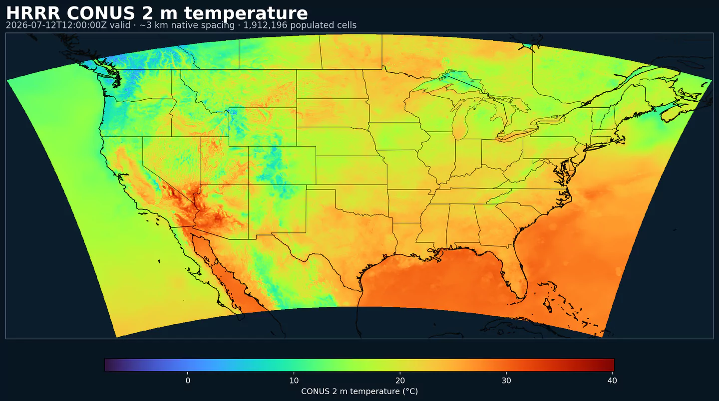
HRRR (High-Resolution Rapid Refresh) is NOAA/NCEP's real-time, convection-allowing model for the contiguous United States. It is designed for short-range workflows where storms, wind shifts, low clouds, fog, smoke, or other local features can change quickly.
HRRR couples a WRF-ARW forecast core with a rapid data-assimilation cycle that ingests surface and mesonet stations, radiosondes, aircraft reports, satellite winds, and MRMS radar reflectivity at high frequency. The model runs on a 3 km CONUS grid, fine enough to represent many convective-scale structures without relying only on coarse convective parameterization.
The system is tuned for mesoscale and boundary-layer phenomena: thunderstorm initiation and evolution, low clouds and fog, snow bands, gap winds, near-surface temperature gradients, and smoke dispersion. The hourly cadence makes it practical for dashboards, alerts, and verification workflows that need new guidance throughout the day.
HRRR guidance is a key short-range input to the NBM and has informed the development of the RRFS. For 15-minute surface valid times, use the companion HRRR Sub-hourly dataset.
Click a parameter to reveal variants in a compact table with ready-to-copy JSON selectors.
Best (4-layer) lifted index uses parcels from the lowest four model layers to assess stability at 500 hPa. More negative values indicate greater instability.
| Level | Info | Horizon | Introduced | Selector |
|---|---|---|---|---|
180-0 mb above ground |
0h-48h | 2014-07-30 |
{"name":"4LFTX","level":"180-0 mb above ground","info":""}
|
Absolute vorticity combines relative vorticity and planetary vorticity from Earth's rotation. It highlights rotation and dynamical forcing in the flow.
| Level | Info | Horizon | Introduced | Selector |
|---|---|---|---|---|
100 mb |
0h-48h | 2014-08-01 |
{"name":"ABSV","level":"100 mb","info":""}
|
|
1000 mb |
0h-48h | 2014-08-01 |
{"name":"ABSV","level":"1000 mb","info":""}
|
|
1013.2 mb |
0h-48h | 2014-08-01 |
{"name":"ABSV","level":"1013.2 mb","info":""}
|
|
125 mb |
0h-48h | 2014-08-01 |
{"name":"ABSV","level":"125 mb","info":""}
|
|
150 mb |
0h-48h | 2014-08-01 |
{"name":"ABSV","level":"150 mb","info":""}
|
|
175 mb |
0h-48h | 2014-08-01 |
{"name":"ABSV","level":"175 mb","info":""}
|
|
200 mb |
0h-48h | 2014-08-01 |
{"name":"ABSV","level":"200 mb","info":""}
|
|
225 mb |
0h-48h | 2014-08-01 |
{"name":"ABSV","level":"225 mb","info":""}
|
|
250 mb |
0h-48h | 2014-08-01 |
{"name":"ABSV","level":"250 mb","info":""}
|
|
275 mb |
0h-48h | 2014-08-01 |
{"name":"ABSV","level":"275 mb","info":""}
|
|
300 mb |
0h-48h | 2014-08-01 |
{"name":"ABSV","level":"300 mb","info":""}
|
|
325 mb |
0h-48h | 2014-08-01 |
{"name":"ABSV","level":"325 mb","info":""}
|
|
350 mb |
0h-48h | 2014-08-01 |
{"name":"ABSV","level":"350 mb","info":""}
|
|
375 mb |
0h-48h | 2014-08-01 |
{"name":"ABSV","level":"375 mb","info":""}
|
|
400 mb |
0h-48h | 2014-08-01 |
{"name":"ABSV","level":"400 mb","info":""}
|
|
425 mb |
0h-48h | 2014-08-01 |
{"name":"ABSV","level":"425 mb","info":""}
|
|
450 mb |
0h-48h | 2014-08-01 |
{"name":"ABSV","level":"450 mb","info":""}
|
|
475 mb |
0h-48h | 2014-08-01 |
{"name":"ABSV","level":"475 mb","info":""}
|
|
50 mb |
0h-48h | 2014-08-01 |
{"name":"ABSV","level":"50 mb","info":""}
|
|
500 mb |
0h-48h | 2014-08-01 |
{"name":"ABSV","level":"500 mb","info":""}
|
|
525 mb |
0h-48h | 2014-08-01 |
{"name":"ABSV","level":"525 mb","info":""}
|
|
550 mb |
0h-48h | 2014-08-01 |
{"name":"ABSV","level":"550 mb","info":""}
|
|
575 mb |
0h-48h | 2014-08-01 |
{"name":"ABSV","level":"575 mb","info":""}
|
|
600 mb |
0h-48h | 2014-08-01 |
{"name":"ABSV","level":"600 mb","info":""}
|
|
625 mb |
0h-48h | 2014-08-01 |
{"name":"ABSV","level":"625 mb","info":""}
|
|
650 mb |
0h-48h | 2014-08-01 |
{"name":"ABSV","level":"650 mb","info":""}
|
|
675 mb |
0h-48h | 2014-08-01 |
{"name":"ABSV","level":"675 mb","info":""}
|
|
700 mb |
0h-48h | 2014-08-01 |
{"name":"ABSV","level":"700 mb","info":""}
|
|
725 mb |
0h-48h | 2014-08-01 |
{"name":"ABSV","level":"725 mb","info":""}
|
|
75 mb |
0h-48h | 2014-08-01 |
{"name":"ABSV","level":"75 mb","info":""}
|
|
750 mb |
0h-48h | 2014-08-01 |
{"name":"ABSV","level":"750 mb","info":""}
|
|
775 mb |
0h-48h | 2014-08-01 |
{"name":"ABSV","level":"775 mb","info":""}
|
|
800 mb |
0h-48h | 2014-08-01 |
{"name":"ABSV","level":"800 mb","info":""}
|
|
825 mb |
0h-48h | 2014-08-01 |
{"name":"ABSV","level":"825 mb","info":""}
|
|
850 mb |
0h-48h | 2014-08-01 |
{"name":"ABSV","level":"850 mb","info":""}
|
|
875 mb |
0h-48h | 2014-08-01 |
{"name":"ABSV","level":"875 mb","info":""}
|
|
900 mb |
0h-48h | 2014-08-01 |
{"name":"ABSV","level":"900 mb","info":""}
|
|
925 mb |
0h-48h | 2014-08-01 |
{"name":"ABSV","level":"925 mb","info":""}
|
|
950 mb |
0h-48h | 2014-08-01 |
{"name":"ABSV","level":"950 mb","info":""}
|
|
975 mb |
0h-48h | 2014-08-01 |
{"name":"ABSV","level":"975 mb","info":""}
|
Aerosol optical thickness represents the column-integrated attenuation of solar radiation by aerosols. Larger values indicate hazier conditions and reduced surface sunlight.
| Level | Info | Horizon | Introduced | Selector |
|---|---|---|---|---|
entire atmosphere (considered as a single layer) |
0h-48h | 2020-12-02 |
{"name":"AOTK","level":"entire atmosphere (considered as a single layer)","info":""}
|
Accumulated precipitation represents the total water-equivalent amount of rain and snow during the output period. It is a primary field for hydrologic impacts and event totals.
| Level | Info | Horizon | Introduced | Selector |
|---|---|---|---|---|
surface |
0h-48h | 2014-07-30 |
{"name":"APCP","level":"surface","info":""}
|
Accumulated snow depth is the total depth of snow on the ground over the period. It is a physical depth, not water equivalent.
| Level | Info | Horizon | Introduced | Selector |
|---|---|---|---|---|
surface |
0h-48h | 2016-08-22 |
{"name":"ASNOW","level":"surface","info":""}
|
Baseflow‑groundwater runoff represents subsurface drainage from soil into streams. It is a slower component of runoff.
| Level | Info | Horizon | Introduced | Selector |
|---|---|---|---|---|
surface |
0h-48h | 2016-08-22 |
{"name":"BGRUN","level":"surface","info":""}
|
Convective Available Potential Energy (CAPE) quantifies buoyant energy available to rising air parcels. Larger values generally imply stronger potential updrafts and greater convective intensity.
| Level | Info | Horizon | Introduced | Selector |
|---|---|---|---|---|
0-3000 m above ground |
0h-48h | 2020-12-02 |
{"name":"CAPE","level":"0-3000 m above ground","info":""}
|
|
180-0 mb above ground |
0h-48h | 2014-07-30 |
{"name":"CAPE","level":"180-0 mb above ground","info":""}
|
|
255-0 mb above ground |
0h-48h | 2014-07-30 |
{"name":"CAPE","level":"255-0 mb above ground","info":""}
|
|
90-0 mb above ground |
0h-48h | 2014-07-30 |
{"name":"CAPE","level":"90-0 mb above ground","info":""}
|
|
surface |
0h-48h | 2014-07-30 |
{"name":"CAPE","level":"surface","info":""}
|
Cloud forcing on net solar flux is the difference between clear-sky and all-sky net shortwave at the surface. It quantifies how much clouds reduce surface solar heating.
| Level | Info | Horizon | Introduced | Selector |
|---|---|---|---|---|
surface |
0h-48h | 2020-12-02 |
{"name":"CFNSF","level":"surface","info":""}
|
Categorical indicator of freezing rain occurrence at the surface during the output period.
| Level | Info | Horizon | Introduced | Selector |
|---|---|---|---|---|
surface |
0h-48h | 2014-07-30 |
{"name":"CFRZR","level":"surface","info":""}
|
Categorical indicator of ice pellet (sleet) occurrence at the surface during the output period.
| Level | Info | Horizon | Introduced | Selector |
|---|---|---|---|---|
surface |
0h-48h | 2014-07-30 |
{"name":"CICEP","level":"surface","info":""}
|
Cloud ice mixing ratio is the mass of ice cloud particles per mass of air. It indicates ice-phase cloud content relevant to precipitation and radiation.
| Level | Info | Horizon | Introduced | Selector |
|---|---|---|---|---|
100 mb |
0h-48h | 2018-07-11 |
{"name":"CIMIXR","level":"100 mb","info":""}
|
|
1000 mb |
0h-48h | 2018-07-11 |
{"name":"CIMIXR","level":"1000 mb","info":""}
|
|
1013.2 mb |
0h-48h | 2018-07-11 |
{"name":"CIMIXR","level":"1013.2 mb","info":""}
|
|
125 mb |
0h-48h | 2018-07-11 |
{"name":"CIMIXR","level":"125 mb","info":""}
|
|
150 mb |
0h-48h | 2018-07-11 |
{"name":"CIMIXR","level":"150 mb","info":""}
|
|
175 mb |
0h-48h | 2018-07-11 |
{"name":"CIMIXR","level":"175 mb","info":""}
|
|
200 mb |
0h-48h | 2018-07-11 |
{"name":"CIMIXR","level":"200 mb","info":""}
|
|
225 mb |
0h-48h | 2018-07-11 |
{"name":"CIMIXR","level":"225 mb","info":""}
|
|
250 mb |
0h-48h | 2018-07-11 |
{"name":"CIMIXR","level":"250 mb","info":""}
|
|
275 mb |
0h-48h | 2018-07-11 |
{"name":"CIMIXR","level":"275 mb","info":""}
|
|
300 mb |
0h-48h | 2018-07-11 |
{"name":"CIMIXR","level":"300 mb","info":""}
|
|
325 mb |
0h-48h | 2018-07-11 |
{"name":"CIMIXR","level":"325 mb","info":""}
|
|
350 mb |
0h-48h | 2018-07-11 |
{"name":"CIMIXR","level":"350 mb","info":""}
|
|
375 mb |
0h-48h | 2018-07-11 |
{"name":"CIMIXR","level":"375 mb","info":""}
|
|
400 mb |
0h-48h | 2018-07-11 |
{"name":"CIMIXR","level":"400 mb","info":""}
|
|
425 mb |
0h-48h | 2018-07-11 |
{"name":"CIMIXR","level":"425 mb","info":""}
|
|
450 mb |
0h-48h | 2018-07-11 |
{"name":"CIMIXR","level":"450 mb","info":""}
|
|
475 mb |
0h-48h | 2018-07-11 |
{"name":"CIMIXR","level":"475 mb","info":""}
|
|
50 mb |
0h-48h | 2018-07-11 |
{"name":"CIMIXR","level":"50 mb","info":""}
|
|
500 mb |
0h-48h | 2018-07-11 |
{"name":"CIMIXR","level":"500 mb","info":""}
|
|
525 mb |
0h-48h | 2018-07-11 |
{"name":"CIMIXR","level":"525 mb","info":""}
|
|
550 mb |
0h-48h | 2018-07-11 |
{"name":"CIMIXR","level":"550 mb","info":""}
|
|
575 mb |
0h-48h | 2018-07-11 |
{"name":"CIMIXR","level":"575 mb","info":""}
|
|
600 mb |
0h-48h | 2018-07-11 |
{"name":"CIMIXR","level":"600 mb","info":""}
|
|
625 mb |
0h-48h | 2018-07-11 |
{"name":"CIMIXR","level":"625 mb","info":""}
|
|
650 mb |
0h-48h | 2018-07-11 |
{"name":"CIMIXR","level":"650 mb","info":""}
|
|
675 mb |
0h-48h | 2018-07-11 |
{"name":"CIMIXR","level":"675 mb","info":""}
|
|
700 mb |
0h-48h | 2018-07-11 |
{"name":"CIMIXR","level":"700 mb","info":""}
|
|
725 mb |
0h-48h | 2018-07-11 |
{"name":"CIMIXR","level":"725 mb","info":""}
|
|
75 mb |
0h-48h | 2018-07-11 |
{"name":"CIMIXR","level":"75 mb","info":""}
|
|
750 mb |
0h-48h | 2018-07-11 |
{"name":"CIMIXR","level":"750 mb","info":""}
|
|
775 mb |
0h-48h | 2018-07-11 |
{"name":"CIMIXR","level":"775 mb","info":""}
|
|
800 mb |
0h-48h | 2018-07-11 |
{"name":"CIMIXR","level":"800 mb","info":""}
|
|
825 mb |
0h-48h | 2018-07-11 |
{"name":"CIMIXR","level":"825 mb","info":""}
|
|
850 mb |
0h-48h | 2018-07-11 |
{"name":"CIMIXR","level":"850 mb","info":""}
|
|
875 mb |
0h-48h | 2018-07-11 |
{"name":"CIMIXR","level":"875 mb","info":""}
|
|
900 mb |
0h-48h | 2018-07-11 |
{"name":"CIMIXR","level":"900 mb","info":""}
|
|
925 mb |
0h-48h | 2018-07-11 |
{"name":"CIMIXR","level":"925 mb","info":""}
|
|
950 mb |
0h-48h | 2018-07-11 |
{"name":"CIMIXR","level":"950 mb","info":""}
|
|
975 mb |
0h-48h | 2018-07-11 |
{"name":"CIMIXR","level":"975 mb","info":""}
|
Convective Inhibition (CIN) measures the energy barrier that must be overcome to initiate convection. More negative values indicate a stronger cap that can suppress storms.
| Level | Info | Horizon | Introduced | Selector |
|---|---|---|---|---|
180-0 mb above ground |
0h-48h | 2014-07-30 |
{"name":"CIN","level":"180-0 mb above ground","info":""}
|
|
255-0 mb above ground |
0h-48h | 2014-07-30 |
{"name":"CIN","level":"255-0 mb above ground","info":""}
|
|
90-0 mb above ground |
0h-48h | 2014-07-30 |
{"name":"CIN","level":"90-0 mb above ground","info":""}
|
|
surface |
0h-48h | 2014-07-30 |
{"name":"CIN","level":"surface","info":""}
|
Cloud liquid water mixing ratio emphasizes the liquid phase of cloud water. It is used in microphysics and fog diagnostics.
| Level | Info | Horizon | Introduced | Selector |
|---|---|---|---|---|
100 mb |
0h-48h | 2019-03-11 |
{"name":"CLWMR","level":"100 mb","info":""}
|
|
1000 mb |
0h-48h | 2019-03-11 |
{"name":"CLWMR","level":"1000 mb","info":""}
|
|
1013.2 mb |
0h-48h | 2019-03-11 |
{"name":"CLWMR","level":"1013.2 mb","info":""}
|
|
125 mb |
0h-48h | 2019-03-11 |
{"name":"CLWMR","level":"125 mb","info":""}
|
|
150 mb |
0h-48h | 2019-03-11 |
{"name":"CLWMR","level":"150 mb","info":""}
|
|
175 mb |
0h-48h | 2019-03-11 |
{"name":"CLWMR","level":"175 mb","info":""}
|
|
200 mb |
0h-48h | 2019-03-11 |
{"name":"CLWMR","level":"200 mb","info":""}
|
|
225 mb |
0h-48h | 2019-03-11 |
{"name":"CLWMR","level":"225 mb","info":""}
|
|
250 mb |
0h-48h | 2019-03-11 |
{"name":"CLWMR","level":"250 mb","info":""}
|
|
275 mb |
0h-48h | 2019-03-11 |
{"name":"CLWMR","level":"275 mb","info":""}
|
|
300 mb |
0h-48h | 2019-03-11 |
{"name":"CLWMR","level":"300 mb","info":""}
|
|
325 mb |
0h-48h | 2019-03-11 |
{"name":"CLWMR","level":"325 mb","info":""}
|
|
350 mb |
0h-48h | 2019-03-11 |
{"name":"CLWMR","level":"350 mb","info":""}
|
|
375 mb |
0h-48h | 2019-03-11 |
{"name":"CLWMR","level":"375 mb","info":""}
|
|
400 mb |
0h-48h | 2019-03-11 |
{"name":"CLWMR","level":"400 mb","info":""}
|
|
425 mb |
0h-48h | 2019-03-11 |
{"name":"CLWMR","level":"425 mb","info":""}
|
|
450 mb |
0h-48h | 2019-03-11 |
{"name":"CLWMR","level":"450 mb","info":""}
|
|
475 mb |
0h-48h | 2019-03-11 |
{"name":"CLWMR","level":"475 mb","info":""}
|
|
50 mb |
0h-48h | 2019-03-11 |
{"name":"CLWMR","level":"50 mb","info":""}
|
|
500 mb |
0h-48h | 2019-03-11 |
{"name":"CLWMR","level":"500 mb","info":""}
|
|
525 mb |
0h-48h | 2019-03-11 |
{"name":"CLWMR","level":"525 mb","info":""}
|
|
550 mb |
0h-48h | 2019-03-11 |
{"name":"CLWMR","level":"550 mb","info":""}
|
|
575 mb |
0h-48h | 2019-03-11 |
{"name":"CLWMR","level":"575 mb","info":""}
|
|
600 mb |
0h-48h | 2019-03-11 |
{"name":"CLWMR","level":"600 mb","info":""}
|
|
625 mb |
0h-48h | 2019-03-11 |
{"name":"CLWMR","level":"625 mb","info":""}
|
|
650 mb |
0h-48h | 2019-03-11 |
{"name":"CLWMR","level":"650 mb","info":""}
|
|
675 mb |
0h-48h | 2019-03-11 |
{"name":"CLWMR","level":"675 mb","info":""}
|
|
700 mb |
0h-48h | 2019-03-11 |
{"name":"CLWMR","level":"700 mb","info":""}
|
|
725 mb |
0h-48h | 2019-03-11 |
{"name":"CLWMR","level":"725 mb","info":""}
|
|
75 mb |
0h-48h | 2019-03-11 |
{"name":"CLWMR","level":"75 mb","info":""}
|
|
750 mb |
0h-48h | 2019-03-11 |
{"name":"CLWMR","level":"750 mb","info":""}
|
|
775 mb |
0h-48h | 2019-03-11 |
{"name":"CLWMR","level":"775 mb","info":""}
|
|
800 mb |
0h-48h | 2019-03-11 |
{"name":"CLWMR","level":"800 mb","info":""}
|
|
825 mb |
0h-48h | 2019-03-11 |
{"name":"CLWMR","level":"825 mb","info":""}
|
|
850 mb |
0h-48h | 2019-03-11 |
{"name":"CLWMR","level":"850 mb","info":""}
|
|
875 mb |
0h-48h | 2019-03-11 |
{"name":"CLWMR","level":"875 mb","info":""}
|
|
900 mb |
0h-48h | 2019-03-11 |
{"name":"CLWMR","level":"900 mb","info":""}
|
|
925 mb |
0h-48h | 2019-03-11 |
{"name":"CLWMR","level":"925 mb","info":""}
|
|
950 mb |
0h-48h | 2019-03-11 |
{"name":"CLWMR","level":"950 mb","info":""}
|
|
975 mb |
0h-48h | 2019-03-11 |
{"name":"CLWMR","level":"975 mb","info":""}
|
Plant canopy surface water is liquid water intercepted by vegetation. It represents interception storage and evaporation potential.
| Level | Info | Horizon | Introduced | Selector |
|---|---|---|---|---|
surface |
0h-48h | 2016-08-22 |
{"name":"CNWAT","level":"surface","info":""}
|
Column-integrated mass density is the total mass per unit area through the vertical column for the specified species. It summarizes column burden and is useful for transport diagnostics.
| Level | Info | Horizon | Introduced | Selector |
|---|---|---|---|---|
entire atmosphere (considered as a single layer) |
0h-48h | 2020-12-02 |
{"name":"COLMD","level":"entire atmosphere (considered as a single layer)","info":""}
|
Percent frozen precipitation indicates the fraction of total precipitation that is falling in frozen form. It helps distinguish mixed-phase and winter precipitation impacts.
| Level | Info | Horizon | Introduced | Selector |
|---|---|---|---|---|
surface |
0h-48h | 2014-07-30 |
{"name":"CPOFP","level":"surface","info":""}
|
Categorical indicator of rain occurrence at the surface during the output period. Useful as a yes/no mask for rain.
| Level | Info | Horizon | Introduced | Selector |
|---|---|---|---|---|
surface |
0h-48h | 2014-07-30 |
{"name":"CRAIN","level":"surface","info":""}
|
Categorical indicator of snow occurrence at the surface during the output period.
| Level | Info | Horizon | Introduced | Selector |
|---|---|---|---|---|
surface |
0h-48h | 2014-07-30 |
{"name":"CSNOW","level":"surface","info":""}
|
Downward longwave (thermal) flux represents incoming energy at the surface. It is a key driver of surface heating and cooling.
| Level | Info | Horizon | Introduced | Selector |
|---|---|---|---|---|
surface |
0h-48h | 2016-08-22 |
{"name":"DLWRF","level":"surface","info":""}
|
Dew point temperature is the temperature at which the air becomes saturated. It is a direct measure of moisture content.
| Level | Info | Horizon | Introduced | Selector |
|---|---|---|---|---|
100 mb |
0h-48h | 2014-08-01 |
{"name":"DPT","level":"100 mb","info":""}
|
|
1000 mb |
0h-48h | 2014-07-30 |
{"name":"DPT","level":"1000 mb","info":""}
|
|
1013.2 mb |
0h-48h | 2014-08-01 |
{"name":"DPT","level":"1013.2 mb","info":""}
|
|
125 mb |
0h-48h | 2014-08-01 |
{"name":"DPT","level":"125 mb","info":""}
|
|
150 mb |
0h-48h | 2014-08-01 |
{"name":"DPT","level":"150 mb","info":""}
|
|
175 mb |
0h-48h | 2014-08-01 |
{"name":"DPT","level":"175 mb","info":""}
|
|
2 m above ground |
0h-48h | 2014-07-30 |
{"name":"DPT","level":"2 m above ground","info":""}
|
|
200 mb |
0h-48h | 2014-08-01 |
{"name":"DPT","level":"200 mb","info":""}
|
|
225 mb |
0h-48h | 2014-08-01 |
{"name":"DPT","level":"225 mb","info":""}
|
|
250 mb |
0h-48h | 2014-08-01 |
{"name":"DPT","level":"250 mb","info":""}
|
|
275 mb |
0h-48h | 2014-08-01 |
{"name":"DPT","level":"275 mb","info":""}
|
|
300 mb |
0h-48h | 2014-08-01 |
{"name":"DPT","level":"300 mb","info":""}
|
|
325 mb |
0h-48h | 2014-08-01 |
{"name":"DPT","level":"325 mb","info":""}
|
|
350 mb |
0h-48h | 2014-08-01 |
{"name":"DPT","level":"350 mb","info":""}
|
|
375 mb |
0h-48h | 2014-08-01 |
{"name":"DPT","level":"375 mb","info":""}
|
|
400 mb |
0h-48h | 2014-08-01 |
{"name":"DPT","level":"400 mb","info":""}
|
|
425 mb |
0h-48h | 2014-08-01 |
{"name":"DPT","level":"425 mb","info":""}
|
|
450 mb |
0h-48h | 2014-08-01 |
{"name":"DPT","level":"450 mb","info":""}
|
|
475 mb |
0h-48h | 2014-08-01 |
{"name":"DPT","level":"475 mb","info":""}
|
|
50 mb |
0h-48h | 2014-08-01 |
{"name":"DPT","level":"50 mb","info":""}
|
|
500 mb |
0h-48h | 2014-07-30 |
{"name":"DPT","level":"500 mb","info":""}
|
|
525 mb |
0h-48h | 2014-08-01 |
{"name":"DPT","level":"525 mb","info":""}
|
|
550 mb |
0h-48h | 2014-08-01 |
{"name":"DPT","level":"550 mb","info":""}
|
|
575 mb |
0h-48h | 2014-08-01 |
{"name":"DPT","level":"575 mb","info":""}
|
|
600 mb |
0h-48h | 2014-08-01 |
{"name":"DPT","level":"600 mb","info":""}
|
|
625 mb |
0h-48h | 2014-08-01 |
{"name":"DPT","level":"625 mb","info":""}
|
|
650 mb |
0h-48h | 2014-08-01 |
{"name":"DPT","level":"650 mb","info":""}
|
|
675 mb |
0h-48h | 2014-08-01 |
{"name":"DPT","level":"675 mb","info":""}
|
|
700 mb |
0h-48h | 2014-07-30 |
{"name":"DPT","level":"700 mb","info":""}
|
|
725 mb |
0h-48h | 2014-08-01 |
{"name":"DPT","level":"725 mb","info":""}
|
|
75 mb |
0h-48h | 2014-08-01 |
{"name":"DPT","level":"75 mb","info":""}
|
|
750 mb |
0h-48h | 2014-08-01 |
{"name":"DPT","level":"750 mb","info":""}
|
|
775 mb |
0h-48h | 2014-08-01 |
{"name":"DPT","level":"775 mb","info":""}
|
|
800 mb |
0h-48h | 2014-08-01 |
{"name":"DPT","level":"800 mb","info":""}
|
|
825 mb |
0h-48h | 2014-08-01 |
{"name":"DPT","level":"825 mb","info":""}
|
|
850 mb |
0h-48h | 2014-07-30 |
{"name":"DPT","level":"850 mb","info":""}
|
|
875 mb |
0h-48h | 2014-08-01 |
{"name":"DPT","level":"875 mb","info":""}
|
|
900 mb |
0h-48h | 2014-08-01 |
{"name":"DPT","level":"900 mb","info":""}
|
|
925 mb |
0h-48h | 2014-07-30 |
{"name":"DPT","level":"925 mb","info":""}
|
|
950 mb |
0h-48h | 2014-08-01 |
{"name":"DPT","level":"950 mb","info":""}
|
|
975 mb |
0h-48h | 2014-08-01 |
{"name":"DPT","level":"975 mb","info":""}
|
Downward radiative flux represents incoming energy at the surface. It is a key driver of surface heating and cooling.
| Level | Info | Horizon | Introduced | Selector |
|---|---|---|---|---|
surface |
0h-48h | 2014-08-02 |
{"name":"DSWRF","level":"surface","info":""}
|
Geometric vertical velocity (dz/dt) is the vertical speed of air in height coordinates. Positive values indicate rising motion and negative values sinking motion.
| Level | Info | Horizon | Introduced | Selector |
|---|---|---|---|---|
0.5-0.8 sigma layer |
0h-48h | 2014-07-30 |
{"name":"DZDT","level":"0.5-0.8 sigma layer","info":""}
|
Friction velocity (u*) is a measure of near‑surface shear stress. It is commonly used in turbulence, dust, and air‑sea exchange calculations.
| Level | Info | Horizon | Introduced | Selector |
|---|---|---|---|---|
surface |
0h-48h | 2016-08-22 |
{"name":"FRICV","level":"surface","info":""}
|
Freezing rain accumulation is the water-equivalent amount of freezing rain during the period. It relates directly to ice accretion risk.
| Level | Info | Horizon | Introduced | Selector |
|---|---|---|---|---|
surface |
0h-48h | 2016-08-22 |
{"name":"FROZR","level":"surface","info":""}
|
Freezing rain accumulation is the water-equivalent amount of freezing rain during the period. It relates directly to ice accretion risk.
| Level | Info | Horizon | Introduced | Selector |
|---|---|---|---|---|
surface |
0h-48h | 2018-07-11 |
{"name":"FRZR","level":"surface","info":""}
|
Ground heat flux is the conductive heat exchange between the surface and the subsurface. It is a key term in the surface energy balance.
| Level | Info | Horizon | Introduced | Selector |
|---|---|---|---|---|
surface |
0h-48h | 2016-08-22 |
{"name":"GFLUX","level":"surface","info":""}
|
Graupel accumulation represents the water-equivalent amount of graupel in the column. It helps diagnose convective microphysics.
| Level | Info | Horizon | Introduced | Selector |
|---|---|---|---|---|
100 mb |
0h-48h | 2014-08-01 |
{"name":"GRLE","level":"100 mb","info":""}
|
|
1000 mb |
0h-48h | 2014-08-01 |
{"name":"GRLE","level":"1000 mb","info":""}
|
|
1013.2 mb |
0h-48h | 2014-08-01 |
{"name":"GRLE","level":"1013.2 mb","info":""}
|
|
125 mb |
0h-48h | 2014-08-01 |
{"name":"GRLE","level":"125 mb","info":""}
|
|
150 mb |
0h-48h | 2014-08-01 |
{"name":"GRLE","level":"150 mb","info":""}
|
|
175 mb |
0h-48h | 2014-08-01 |
{"name":"GRLE","level":"175 mb","info":""}
|
|
200 mb |
0h-48h | 2014-08-01 |
{"name":"GRLE","level":"200 mb","info":""}
|
|
225 mb |
0h-48h | 2014-08-01 |
{"name":"GRLE","level":"225 mb","info":""}
|
|
250 mb |
0h-48h | 2014-08-01 |
{"name":"GRLE","level":"250 mb","info":""}
|
|
275 mb |
0h-48h | 2014-08-01 |
{"name":"GRLE","level":"275 mb","info":""}
|
|
300 mb |
0h-48h | 2014-08-01 |
{"name":"GRLE","level":"300 mb","info":""}
|
|
325 mb |
0h-48h | 2014-08-01 |
{"name":"GRLE","level":"325 mb","info":""}
|
|
350 mb |
0h-48h | 2014-08-01 |
{"name":"GRLE","level":"350 mb","info":""}
|
|
375 mb |
0h-48h | 2014-08-01 |
{"name":"GRLE","level":"375 mb","info":""}
|
|
400 mb |
0h-48h | 2014-08-01 |
{"name":"GRLE","level":"400 mb","info":""}
|
|
425 mb |
0h-48h | 2014-08-01 |
{"name":"GRLE","level":"425 mb","info":""}
|
|
450 mb |
0h-48h | 2014-08-01 |
{"name":"GRLE","level":"450 mb","info":""}
|
|
475 mb |
0h-48h | 2014-08-01 |
{"name":"GRLE","level":"475 mb","info":""}
|
|
50 mb |
0h-48h | 2014-08-01 |
{"name":"GRLE","level":"50 mb","info":""}
|
|
500 mb |
0h-48h | 2014-08-01 |
{"name":"GRLE","level":"500 mb","info":""}
|
|
525 mb |
0h-48h | 2014-08-01 |
{"name":"GRLE","level":"525 mb","info":""}
|
|
550 mb |
0h-48h | 2014-08-01 |
{"name":"GRLE","level":"550 mb","info":""}
|
|
575 mb |
0h-48h | 2014-08-01 |
{"name":"GRLE","level":"575 mb","info":""}
|
|
600 mb |
0h-48h | 2014-08-01 |
{"name":"GRLE","level":"600 mb","info":""}
|
|
625 mb |
0h-48h | 2014-08-01 |
{"name":"GRLE","level":"625 mb","info":""}
|
|
650 mb |
0h-48h | 2014-08-01 |
{"name":"GRLE","level":"650 mb","info":""}
|
|
675 mb |
0h-48h | 2014-08-01 |
{"name":"GRLE","level":"675 mb","info":""}
|
|
700 mb |
0h-48h | 2014-08-01 |
{"name":"GRLE","level":"700 mb","info":""}
|
|
725 mb |
0h-48h | 2014-08-01 |
{"name":"GRLE","level":"725 mb","info":""}
|
|
75 mb |
0h-48h | 2014-08-01 |
{"name":"GRLE","level":"75 mb","info":""}
|
|
750 mb |
0h-48h | 2014-08-01 |
{"name":"GRLE","level":"750 mb","info":""}
|
|
775 mb |
0h-48h | 2014-08-01 |
{"name":"GRLE","level":"775 mb","info":""}
|
|
800 mb |
0h-48h | 2014-08-01 |
{"name":"GRLE","level":"800 mb","info":""}
|
|
825 mb |
0h-48h | 2014-08-01 |
{"name":"GRLE","level":"825 mb","info":""}
|
|
850 mb |
0h-48h | 2014-08-01 |
{"name":"GRLE","level":"850 mb","info":""}
|
|
875 mb |
0h-48h | 2014-08-01 |
{"name":"GRLE","level":"875 mb","info":""}
|
|
900 mb |
0h-48h | 2014-08-01 |
{"name":"GRLE","level":"900 mb","info":""}
|
|
925 mb |
0h-48h | 2014-08-01 |
{"name":"GRLE","level":"925 mb","info":""}
|
|
950 mb |
0h-48h | 2014-08-01 |
{"name":"GRLE","level":"950 mb","info":""}
|
|
975 mb |
0h-48h | 2014-08-01 |
{"name":"GRLE","level":"975 mb","info":""}
|
Wind gust is the peak short-duration wind speed. It captures brief, hazardous bursts that can exceed sustained winds.
| Level | Info | Horizon | Introduced | Selector |
|---|---|---|---|---|
surface |
0h-48h | 2014-07-30 |
{"name":"GUST","level":"surface","info":""}
|
Hail represents hail size as a length measure. Larger values indicate more severe hail potential.
| Level | Info | Horizon | Introduced | Selector |
|---|---|---|---|---|
0.1 sigma level |
0h-48h | 2018-07-11 |
{"name":"HAIL","level":"0.1 sigma level","info":""}
|
|
entire atmosphere |
0h-48h | 2018-07-11 |
{"name":"HAIL","level":"entire atmosphere","info":""}
|
High cloud cover is the fraction of the grid cell covered by clouds in the upper troposphere. It affects longwave radiation and aviation.
| Level | Info | Horizon | Introduced | Selector |
|---|---|---|---|---|
high cloud layer |
0h-48h | 2014-07-30 |
{"name":"HCDC","level":"high cloud layer","info":""}
|
Geopotential height is the altitude of a pressure surface in the atmosphere. It is the primary field for identifying ridges, troughs, and large‑scale flow patterns.
| Level | Info | Horizon | Introduced | Selector |
|---|---|---|---|---|
0C isotherm |
0h-48h | 2016-08-22 |
{"name":"HGT","level":"0C isotherm","info":""}
|
|
100 mb |
0h-48h | 2014-08-01 |
{"name":"HGT","level":"100 mb","info":""}
|
|
1000 mb |
0h-48h | 2014-07-30 |
{"name":"HGT","level":"1000 mb","info":""}
|
|
1013.2 mb |
0h-48h | 2014-08-01 |
{"name":"HGT","level":"1013.2 mb","info":""}
|
|
125 mb |
0h-48h | 2014-08-01 |
{"name":"HGT","level":"125 mb","info":""}
|
|
150 mb |
0h-48h | 2014-08-01 |
{"name":"HGT","level":"150 mb","info":""}
|
|
175 mb |
0h-48h | 2014-08-01 |
{"name":"HGT","level":"175 mb","info":""}
|
|
200 mb |
0h-48h | 2014-08-01 |
{"name":"HGT","level":"200 mb","info":""}
|
|
225 mb |
0h-48h | 2014-08-01 |
{"name":"HGT","level":"225 mb","info":""}
|
|
250 mb |
0h-48h | 2014-08-01 |
{"name":"HGT","level":"250 mb","info":""}
|
|
253 K level |
0h-48h | 2016-08-22 |
{"name":"HGT","level":"253 K level","info":""}
|
|
263 K level |
0h-48h | 2016-08-22 |
{"name":"HGT","level":"263 K level","info":""}
|
|
275 mb |
0h-48h | 2014-08-01 |
{"name":"HGT","level":"275 mb","info":""}
|
|
300 mb |
0h-48h | 2014-08-01 |
{"name":"HGT","level":"300 mb","info":""}
|
|
325 mb |
0h-48h | 2014-08-01 |
{"name":"HGT","level":"325 mb","info":""}
|
|
350 mb |
0h-48h | 2014-08-01 |
{"name":"HGT","level":"350 mb","info":""}
|
|
375 mb |
0h-48h | 2014-08-01 |
{"name":"HGT","level":"375 mb","info":""}
|
|
400 mb |
0h-48h | 2014-08-01 |
{"name":"HGT","level":"400 mb","info":""}
|
|
425 mb |
0h-48h | 2014-08-01 |
{"name":"HGT","level":"425 mb","info":""}
|
|
450 mb |
0h-48h | 2014-08-01 |
{"name":"HGT","level":"450 mb","info":""}
|
|
475 mb |
0h-48h | 2014-08-01 |
{"name":"HGT","level":"475 mb","info":""}
|
|
50 mb |
0h-48h | 2014-08-01 |
{"name":"HGT","level":"50 mb","info":""}
|
|
500 mb |
0h-48h | 2014-07-30 |
{"name":"HGT","level":"500 mb","info":""}
|
|
525 mb |
0h-48h | 2014-08-01 |
{"name":"HGT","level":"525 mb","info":""}
|
|
550 mb |
0h-48h | 2014-08-01 |
{"name":"HGT","level":"550 mb","info":""}
|
|
575 mb |
0h-48h | 2014-08-01 |
{"name":"HGT","level":"575 mb","info":""}
|
|
600 mb |
0h-48h | 2014-08-01 |
{"name":"HGT","level":"600 mb","info":""}
|
|
625 mb |
0h-48h | 2014-08-01 |
{"name":"HGT","level":"625 mb","info":""}
|
|
650 mb |
0h-48h | 2014-08-01 |
{"name":"HGT","level":"650 mb","info":""}
|
|
675 mb |
0h-48h | 2014-08-01 |
{"name":"HGT","level":"675 mb","info":""}
|
|
700 mb |
0h-48h | 2014-07-30 |
{"name":"HGT","level":"700 mb","info":""}
|
|
725 mb |
0h-48h | 2014-08-01 |
{"name":"HGT","level":"725 mb","info":""}
|
|
75 mb |
0h-48h | 2014-08-01 |
{"name":"HGT","level":"75 mb","info":""}
|
|
750 mb |
0h-48h | 2014-08-01 |
{"name":"HGT","level":"750 mb","info":""}
|
|
775 mb |
0h-48h | 2014-08-01 |
{"name":"HGT","level":"775 mb","info":""}
|
|
800 mb |
0h-48h | 2014-08-01 |
{"name":"HGT","level":"800 mb","info":""}
|
|
825 mb |
0h-48h | 2014-08-01 |
{"name":"HGT","level":"825 mb","info":""}
|
|
850 mb |
0h-48h | 2014-07-30 |
{"name":"HGT","level":"850 mb","info":""}
|
|
875 mb |
0h-48h | 2014-08-01 |
{"name":"HGT","level":"875 mb","info":""}
|
|
900 mb |
0h-48h | 2014-08-01 |
{"name":"HGT","level":"900 mb","info":""}
|
|
925 mb |
0h-48h | 2014-08-01 |
{"name":"HGT","level":"925 mb","info":""}
|
|
950 mb |
0h-48h | 2014-08-01 |
{"name":"HGT","level":"950 mb","info":""}
|
|
975 mb |
0h-48h | 2014-08-01 |
{"name":"HGT","level":"975 mb","info":""}
|
|
cloud base |
0h-48h | 2014-07-30 |
{"name":"HGT","level":"cloud base","info":""}
|
|
cloud ceiling |
0h-48h | 2014-07-30 |
{"name":"HGT","level":"cloud ceiling","info":""}
|
|
cloud top |
0h-48h | 2014-07-30 |
{"name":"HGT","level":"cloud top","info":""}
|
|
equilibrium level |
0h-48h | 2014-07-30 |
{"name":"HGT","level":"equilibrium level","info":""}
|
|
highest tropospheric freezing level |
0h-48h | 2016-08-22 |
{"name":"HGT","level":"highest tropospheric freezing level","info":""}
|
|
level of adiabatic condensation from sfc |
0h-48h | 2014-07-30 |
{"name":"HGT","level":"level of adiabatic condensation from sfc","info":""}
|
|
level of free convection |
0h-48h | 2021-12-21 |
{"name":"HGT","level":"level of free convection","info":""}
|
|
surface |
0h-48h | 2014-07-30 |
{"name":"HGT","level":"surface","info":""}
|
Storm-relative helicity measures the potential for streamwise vorticity to be ingested by a storm updraft. Higher values suggest a greater likelihood of rotating updrafts.
| Level | Info | Horizon | Introduced | Selector |
|---|---|---|---|---|
1000-0 m above ground |
0h-48h | 2014-07-30 |
{"name":"HLCY","level":"1000-0 m above ground","info":""}
|
|
3000-0 m above ground |
0h-48h | 2014-07-30 |
{"name":"HLCY","level":"3000-0 m above ground","info":""}
|
Boundary layer height marks the depth of the turbulent surface-influenced layer. It affects mixing, dispersion, and surface fluxes.
| Level | Info | Horizon | Introduced | Selector |
|---|---|---|---|---|
surface |
0h-48h | 2014-07-30 |
{"name":"HPBL","level":"surface","info":""}
|
Ice cover is the proportion of the grid cell covered by ice. It is used as a surface-state mask for sea ice and related cryosphere diagnostics.
| Level | Info | Horizon | Introduced | Selector |
|---|---|---|---|---|
surface |
0h-48h | 2014-07-30 |
{"name":"ICEC","level":"surface","info":""}
|
Land cover is a land/sea mask where 0 indicates sea and 1 indicates land. It is used to separate land and ocean surface processes.
| Level | Info | Horizon | Introduced | Selector |
|---|---|---|---|---|
surface |
0h-48h | 2014-07-30 |
{"name":"LAND","level":"surface","info":""}
|
Layer thickness is the vertical distance between the bounds of a layer. It helps interpret thermodynamic and lifted-layer diagnostics.
| Level | Info | Horizon | Introduced | Selector |
|---|---|---|---|---|
261 K level - 256 K level |
0h-48h | 2020-12-02 |
{"name":"LAYTH","level":"261 K level - 256 K level","info":""}
|
Low cloud cover is the fraction of the grid cell covered by low clouds. It strongly affects visibility, fog potential, and surface temperatures.
| Level | Info | Horizon | Introduced | Selector |
|---|---|---|---|---|
low cloud layer |
0h-48h | 2014-07-30 |
{"name":"LCDC","level":"low cloud layer","info":""}
|
Lifted Index compares a lifted parcel's temperature to the environment at 500 hPa. More negative values indicate greater instability and thunderstorm potential.
| Level | Info | Horizon | Introduced | Selector |
|---|---|---|---|---|
500-1000 mb |
0h-48h | 2014-07-30 |
{"name":"LFTX","level":"500-1000 mb","info":""}
|
Latent heat net flux represents energy exchange due to evaporation/condensation at the surface. It links moisture and energy budgets.
| Level | Info | Horizon | Introduced | Selector |
|---|---|---|---|---|
surface |
0h-48h | 2016-08-22 |
{"name":"LHTFL","level":"surface","info":""}
|
Lightning is a dimensionless model diagnostic in these NOAA mesoscale inventories. Higher values indicate greater modeled lightning or convective electrical activity.
| Level | Info | Horizon | Introduced | Selector |
|---|---|---|---|---|
entire atmosphere |
0h-48h | 2016-08-22 |
{"name":"LTNG","level":"entire atmosphere","info":""}
|
Mass density (concentration) represents mass per unit volume of the named species or medium. It is used for concentration and transport analyses.
| Level | Info | Horizon | Introduced | Selector |
|---|---|---|---|---|
8 m above ground |
0h-48h | 2020-12-02 |
{"name":"MASSDEN","level":"8 m above ground","info":""}
|
Hourly maximum downward vertical velocity in the lowest 400 hPa highlights the strongest subsidence within the lower troposphere during the hour.
| Level | Info | Horizon | Introduced | Selector |
|---|---|---|---|---|
100-1000 mb above ground |
0h-48h | 2018-07-11 |
{"name":"MAXDVV","level":"100-1000 mb above ground","info":""}
|
Hourly maximum simulated reflectivity at 1 km AGL captures the strongest modeled reflectivity near the surface. It is used to identify peak convective intensity and heavy precipitation cores.
| Level | Info | Horizon | Introduced | Selector |
|---|---|---|---|---|
1000 m above ground |
0h-48h | 2014-07-30 |
{"name":"MAXREF","level":"1000 m above ground","info":""}
|
Hourly maximum upward vertical velocity in the lowest 400 hPa highlights the strongest updrafts within the lower troposphere during the hour.
| Level | Info | Horizon | Introduced | Selector |
|---|---|---|---|---|
100-1000 mb above ground |
0h-48h | 2018-07-11 |
{"name":"MAXUVV","level":"100-1000 mb above ground","info":""}
|
Mid-level cloud cover is the fraction of the grid cell covered by clouds in the middle troposphere. It influences both shortwave and longwave radiation.
| Level | Info | Horizon | Introduced | Selector |
|---|---|---|---|---|
middle cloud layer |
0h-48h | 2014-07-30 |
{"name":"MCDC","level":"middle cloud layer","info":""}
|
Hourly minimum updraft helicity is the lowest helicity value during the hour. It provides a lower bound on rotating updraft potential.
| Level | Info | Horizon | Introduced | Selector |
|---|---|---|---|---|
2000-0 m above ground |
0h-48h | 2018-07-11 |
{"name":"MNUPHL","level":"2000-0 m above ground","info":""}
|
|
3000-0 m above ground |
0h-48h | 2018-07-11 |
{"name":"MNUPHL","level":"3000-0 m above ground","info":""}
|
|
5000-2000 m above ground |
0h-48h | 2018-07-11 |
{"name":"MNUPHL","level":"5000-2000 m above ground","info":""}
|
Moisture availability represents how much moisture is available at the surface for evaporation. It is used in land-surface and fire-weather diagnostics.
| Level | Info | Horizon | Introduced | Selector |
|---|---|---|---|---|
0 m underground |
0h-48h | 2014-07-30 |
{"name":"MSTAV","level":"0 m underground","info":""}
|
Hourly maximum updraft helicity (2–5 km AGL) highlights the strongest rotating updrafts during the hour.
| Level | Info | Horizon | Introduced | Selector |
|---|---|---|---|---|
2000-0 m above ground |
0h-48h | 2018-07-11 |
{"name":"MXUPHL","level":"2000-0 m above ground","info":""}
|
|
3000-0 m above ground |
0h-48h | 2018-07-11 |
{"name":"MXUPHL","level":"3000-0 m above ground","info":""}
|
|
5000-2000 m above ground |
0h-48h | 2014-07-30 |
{"name":"MXUPHL","level":"5000-2000 m above ground","info":""}
|
Pressure of the level from which the parcel was lifted indicates the parcel source level used for stability indices. It helps interpret lifted index and CAPE products.
| Level | Info | Horizon | Introduced | Selector |
|---|---|---|---|---|
255-0 mb above ground |
0h-48h | 2014-07-30 |
{"name":"PLPL","level":"255-0 mb above ground","info":""}
|
Potential temperature is the temperature a parcel would have if brought dry‑adiabatically to a reference pressure. It is used for stability.
| Level | Info | Horizon | Introduced | Selector |
|---|---|---|---|---|
2 m above ground |
0h-48h | 2016-08-22 |
{"name":"POT","level":"2 m above ground","info":""}
|
Precipitation rate is the total intensity of precipitation over the period. It combines convective and stratiform contributions.
| Level | Info | Horizon | Introduced | Selector |
|---|---|---|---|---|
surface |
0h-48h | 2014-07-30 |
{"name":"PRATE","level":"surface","info":""}
|
Pressure is the atmospheric pressure at the specified level. It is a fundamental mass-field variable for dynamics and thermodynamics.
| Level | Info | Horizon | Introduced | Selector |
|---|---|---|---|---|
0C isotherm |
0h-48h | 2016-08-22 |
{"name":"PRES","level":"0C isotherm","info":""}
|
|
cloud base |
0h-48h | 2014-07-30 |
{"name":"PRES","level":"cloud base","info":""}
|
|
cloud top |
0h-48h | 2014-07-30 |
{"name":"PRES","level":"cloud top","info":""}
|
|
highest tropospheric freezing level |
0h-48h | 2016-08-22 |
{"name":"PRES","level":"highest tropospheric freezing level","info":""}
|
|
surface |
0h-48h | 2014-07-30 |
{"name":"PRES","level":"surface","info":""}
|
Precipitable water is the total column water vapor from the surface to the top of the atmosphere. It is a key moisture indicator.
| Level | Info | Horizon | Introduced | Selector |
|---|---|---|---|---|
entire atmosphere (considered as a single layer) |
0h-48h | 2014-07-30 |
{"name":"PWAT","level":"entire atmosphere (considered as a single layer)","info":""}
|
Composite reflectivity is the maximum reflectivity in the column. It is a standard radar‑style field for identifying convective cores and precipitation intensity.
| Level | Info | Horizon | Introduced | Selector |
|---|---|---|---|---|
entire atmosphere |
0h-48h | 2014-07-30 |
{"name":"REFC","level":"entire atmosphere","info":""}
|
Reflectivity is a radar‑style measure of hydrometeor concentration at a given level. Higher values generally correspond to heavier precipitation.
| Level | Info | Horizon | Introduced | Selector |
|---|---|---|---|---|
1000 m above ground |
0h-48h | 2014-07-30 |
{"name":"REFD","level":"1000 m above ground","info":""}
|
|
263 K level |
0h-48h | 2016-08-22 |
{"name":"REFD","level":"263 K level","info":""}
|
|
4000 m above ground |
0h-48h | 2014-07-30 |
{"name":"REFD","level":"4000 m above ground","info":""}
|
Relative vorticity measures local rotation of the horizontal wind field. Positive values indicate cyclonic rotation and negative values anticyclonic rotation.
| Level | Info | Horizon | Introduced | Selector |
|---|---|---|---|---|
1000-0 m above ground |
0h-48h | 2018-07-11 |
{"name":"RELV","level":"1000-0 m above ground","info":""}
|
|
2000-0 m above ground |
0h-48h | 2018-07-11 |
{"name":"RELV","level":"2000-0 m above ground","info":""}
|
Echo top height is the altitude of the highest reflectivity in the column. It is a proxy for storm depth and convective vigor.
| Level | Info | Horizon | Introduced | Selector |
|---|---|---|---|---|
cloud top |
0h-48h | 2014-07-30 |
{"name":"RETOP","level":"cloud top","info":""}
|
Relative humidity describes how close the air is to saturation at the specified level. High values favor cloud formation.
| Level | Info | Horizon | Introduced | Selector |
|---|---|---|---|---|
0C isotherm |
0h-48h | 2016-08-22 |
{"name":"RH","level":"0C isotherm","info":""}
|
|
100 mb |
0h-48h | 2014-08-01 |
{"name":"RH","level":"100 mb","info":""}
|
|
1000 mb |
0h-48h | 2014-08-01 |
{"name":"RH","level":"1000 mb","info":""}
|
|
1013.2 mb |
0h-48h | 2014-08-01 |
{"name":"RH","level":"1013.2 mb","info":""}
|
|
125 mb |
0h-48h | 2014-08-01 |
{"name":"RH","level":"125 mb","info":""}
|
|
150 mb |
0h-48h | 2014-08-01 |
{"name":"RH","level":"150 mb","info":""}
|
|
175 mb |
0h-48h | 2014-08-01 |
{"name":"RH","level":"175 mb","info":""}
|
|
2 m above ground |
0h-48h | 2016-08-22 |
{"name":"RH","level":"2 m above ground","info":""}
|
|
200 mb |
0h-48h | 2014-08-01 |
{"name":"RH","level":"200 mb","info":""}
|
|
225 mb |
0h-48h | 2014-08-01 |
{"name":"RH","level":"225 mb","info":""}
|
|
250 mb |
0h-48h | 2014-08-01 |
{"name":"RH","level":"250 mb","info":""}
|
|
275 mb |
0h-48h | 2014-08-01 |
{"name":"RH","level":"275 mb","info":""}
|
|
300 mb |
0h-48h | 2014-08-01 |
{"name":"RH","level":"300 mb","info":""}
|
|
325 mb |
0h-48h | 2014-08-01 |
{"name":"RH","level":"325 mb","info":""}
|
|
350 mb |
0h-48h | 2014-08-01 |
{"name":"RH","level":"350 mb","info":""}
|
|
375 mb |
0h-48h | 2014-08-01 |
{"name":"RH","level":"375 mb","info":""}
|
|
400 mb |
0h-48h | 2014-08-01 |
{"name":"RH","level":"400 mb","info":""}
|
|
425 mb |
0h-48h | 2014-08-01 |
{"name":"RH","level":"425 mb","info":""}
|
|
450 mb |
0h-48h | 2014-08-01 |
{"name":"RH","level":"450 mb","info":""}
|
|
475 mb |
0h-48h | 2014-08-01 |
{"name":"RH","level":"475 mb","info":""}
|
|
50 mb |
0h-48h | 2014-08-01 |
{"name":"RH","level":"50 mb","info":""}
|
|
500 mb |
0h-48h | 2014-08-01 |
{"name":"RH","level":"500 mb","info":""}
|
|
525 mb |
0h-48h | 2014-08-01 |
{"name":"RH","level":"525 mb","info":""}
|
|
550 mb |
0h-48h | 2014-08-01 |
{"name":"RH","level":"550 mb","info":""}
|
|
575 mb |
0h-48h | 2014-08-01 |
{"name":"RH","level":"575 mb","info":""}
|
|
600 mb |
0h-48h | 2014-08-01 |
{"name":"RH","level":"600 mb","info":""}
|
|
625 mb |
0h-48h | 2014-08-01 |
{"name":"RH","level":"625 mb","info":""}
|
|
650 mb |
0h-48h | 2014-08-01 |
{"name":"RH","level":"650 mb","info":""}
|
|
675 mb |
0h-48h | 2014-08-01 |
{"name":"RH","level":"675 mb","info":""}
|
|
700 mb |
0h-48h | 2014-08-01 |
{"name":"RH","level":"700 mb","info":""}
|
|
725 mb |
0h-48h | 2014-08-01 |
{"name":"RH","level":"725 mb","info":""}
|
|
75 mb |
0h-48h | 2014-08-01 |
{"name":"RH","level":"75 mb","info":""}
|
|
750 mb |
0h-48h | 2014-08-01 |
{"name":"RH","level":"750 mb","info":""}
|
|
775 mb |
0h-48h | 2014-08-01 |
{"name":"RH","level":"775 mb","info":""}
|
|
800 mb |
0h-48h | 2014-08-01 |
{"name":"RH","level":"800 mb","info":""}
|
|
825 mb |
0h-48h | 2014-08-01 |
{"name":"RH","level":"825 mb","info":""}
|
|
850 mb |
0h-48h | 2014-08-01 |
{"name":"RH","level":"850 mb","info":""}
|
|
875 mb |
0h-48h | 2014-08-01 |
{"name":"RH","level":"875 mb","info":""}
|
|
900 mb |
0h-48h | 2014-08-01 |
{"name":"RH","level":"900 mb","info":""}
|
|
925 mb |
0h-48h | 2014-08-01 |
{"name":"RH","level":"925 mb","info":""}
|
|
950 mb |
0h-48h | 2014-08-01 |
{"name":"RH","level":"950 mb","info":""}
|
|
975 mb |
0h-48h | 2014-08-01 |
{"name":"RH","level":"975 mb","info":""}
|
|
highest tropospheric freezing level |
0h-48h | 2016-08-22 |
{"name":"RH","level":"highest tropospheric freezing level","info":""}
|
Relative humidity with respect to precipitable water is a column‑scale moisture indicator based on total water vapor content.
| Level | Info | Horizon | Introduced | Selector |
|---|---|---|---|---|
entire atmosphere |
0h-48h | 2016-08-22 |
{"name":"RHPW","level":"entire atmosphere","info":""}
|
Rain water mixing ratio is the mass of rainwater per mass of air. It describes rain content within the column.
| Level | Info | Horizon | Introduced | Selector |
|---|---|---|---|---|
100 mb |
0h-48h | 2014-08-01 |
{"name":"RWMR","level":"100 mb","info":""}
|
|
1000 mb |
0h-48h | 2014-08-01 |
{"name":"RWMR","level":"1000 mb","info":""}
|
|
1013.2 mb |
0h-48h | 2014-08-01 |
{"name":"RWMR","level":"1013.2 mb","info":""}
|
|
125 mb |
0h-48h | 2014-08-01 |
{"name":"RWMR","level":"125 mb","info":""}
|
|
150 mb |
0h-48h | 2014-08-01 |
{"name":"RWMR","level":"150 mb","info":""}
|
|
175 mb |
0h-48h | 2014-08-01 |
{"name":"RWMR","level":"175 mb","info":""}
|
|
200 mb |
0h-48h | 2014-08-01 |
{"name":"RWMR","level":"200 mb","info":""}
|
|
225 mb |
0h-48h | 2014-08-01 |
{"name":"RWMR","level":"225 mb","info":""}
|
|
250 mb |
0h-48h | 2014-08-01 |
{"name":"RWMR","level":"250 mb","info":""}
|
|
275 mb |
0h-48h | 2014-08-01 |
{"name":"RWMR","level":"275 mb","info":""}
|
|
300 mb |
0h-48h | 2014-08-01 |
{"name":"RWMR","level":"300 mb","info":""}
|
|
325 mb |
0h-48h | 2014-08-01 |
{"name":"RWMR","level":"325 mb","info":""}
|
|
350 mb |
0h-48h | 2014-08-01 |
{"name":"RWMR","level":"350 mb","info":""}
|
|
375 mb |
0h-48h | 2014-08-01 |
{"name":"RWMR","level":"375 mb","info":""}
|
|
400 mb |
0h-48h | 2014-08-01 |
{"name":"RWMR","level":"400 mb","info":""}
|
|
425 mb |
0h-48h | 2014-08-01 |
{"name":"RWMR","level":"425 mb","info":""}
|
|
450 mb |
0h-48h | 2014-08-01 |
{"name":"RWMR","level":"450 mb","info":""}
|
|
475 mb |
0h-48h | 2014-08-01 |
{"name":"RWMR","level":"475 mb","info":""}
|
|
50 mb |
0h-48h | 2014-08-01 |
{"name":"RWMR","level":"50 mb","info":""}
|
|
500 mb |
0h-48h | 2014-08-01 |
{"name":"RWMR","level":"500 mb","info":""}
|
|
525 mb |
0h-48h | 2014-08-01 |
{"name":"RWMR","level":"525 mb","info":""}
|
|
550 mb |
0h-48h | 2014-08-01 |
{"name":"RWMR","level":"550 mb","info":""}
|
|
575 mb |
0h-48h | 2014-08-01 |
{"name":"RWMR","level":"575 mb","info":""}
|
|
600 mb |
0h-48h | 2014-08-01 |
{"name":"RWMR","level":"600 mb","info":""}
|
|
625 mb |
0h-48h | 2014-08-01 |
{"name":"RWMR","level":"625 mb","info":""}
|
|
650 mb |
0h-48h | 2014-08-01 |
{"name":"RWMR","level":"650 mb","info":""}
|
|
675 mb |
0h-48h | 2014-08-01 |
{"name":"RWMR","level":"675 mb","info":""}
|
|
700 mb |
0h-48h | 2014-08-01 |
{"name":"RWMR","level":"700 mb","info":""}
|
|
725 mb |
0h-48h | 2014-08-01 |
{"name":"RWMR","level":"725 mb","info":""}
|
|
75 mb |
0h-48h | 2014-08-01 |
{"name":"RWMR","level":"75 mb","info":""}
|
|
750 mb |
0h-48h | 2014-08-01 |
{"name":"RWMR","level":"750 mb","info":""}
|
|
775 mb |
0h-48h | 2014-08-01 |
{"name":"RWMR","level":"775 mb","info":""}
|
|
800 mb |
0h-48h | 2014-08-01 |
{"name":"RWMR","level":"800 mb","info":""}
|
|
825 mb |
0h-48h | 2014-08-01 |
{"name":"RWMR","level":"825 mb","info":""}
|
|
850 mb |
0h-48h | 2014-08-01 |
{"name":"RWMR","level":"850 mb","info":""}
|
|
875 mb |
0h-48h | 2014-08-01 |
{"name":"RWMR","level":"875 mb","info":""}
|
|
900 mb |
0h-48h | 2014-08-01 |
{"name":"RWMR","level":"900 mb","info":""}
|
|
925 mb |
0h-48h | 2014-08-01 |
{"name":"RWMR","level":"925 mb","info":""}
|
|
950 mb |
0h-48h | 2014-08-01 |
{"name":"RWMR","level":"950 mb","info":""}
|
|
975 mb |
0h-48h | 2014-08-01 |
{"name":"RWMR","level":"975 mb","info":""}
|
Simulated brightness temperature for GOES-11 channel 3 represents modeled radiance converted to an equivalent blackbody temperature. It supports satellite comparison and cloud diagnostics.
| Level | Info | Horizon | Introduced | Selector |
|---|---|---|---|---|
top of atmosphere |
0h-48h | 2016-08-22 |
{"name":"SBT113","level":"top of atmosphere","info":""}
|
Simulated brightness temperature for GOES-11 channel 4 represents modeled radiance converted to an equivalent blackbody temperature. It supports satellite comparison and cloud diagnostics.
| Level | Info | Horizon | Introduced | Selector |
|---|---|---|---|---|
top of atmosphere |
0h-48h | 2016-08-22 |
{"name":"SBT114","level":"top of atmosphere","info":""}
|
Simulated brightness temperature for GOES-12 channel 3 represents modeled radiance converted to an equivalent blackbody temperature. It supports satellite comparison and cloud diagnostics.
| Level | Info | Horizon | Introduced | Selector |
|---|---|---|---|---|
top of atmosphere |
0h-48h | 2016-08-22 |
{"name":"SBT123","level":"top of atmosphere","info":""}
|
Simulated brightness temperature for GOES-12 channel 4 represents modeled radiance converted to an equivalent blackbody temperature. It supports satellite comparison and cloud diagnostics.
| Level | Info | Horizon | Introduced | Selector |
|---|---|---|---|---|
top of atmosphere |
0h-48h | 2016-08-22 |
{"name":"SBT124","level":"top of atmosphere","info":""}
|
Surface roughness length is the effective height of surface obstacles that control drag. It strongly influences near-surface wind, turbulence, and exchange fluxes.
| Level | Info | Horizon | Introduced | Selector |
|---|---|---|---|---|
surface |
0h-48h | 2016-08-22 |
{"name":"SFCR","level":"surface","info":""}
|
Sensible heat net flux is turbulent heat exchange driven by temperature differences. It affects near‑surface temperature and stability.
| Level | Info | Horizon | Introduced | Selector |
|---|---|---|---|---|
surface |
0h-48h | 2016-08-22 |
{"name":"SHTFL","level":"surface","info":""}
|
Snow mixing ratio is the mass of snow particles per mass of air. It describes suspended snow content relevant to microphysics and precipitation.
| Level | Info | Horizon | Introduced | Selector |
|---|---|---|---|---|
100 mb |
0h-48h | 2014-08-01 |
{"name":"SNMR","level":"100 mb","info":""}
|
|
1000 mb |
0h-48h | 2014-08-01 |
{"name":"SNMR","level":"1000 mb","info":""}
|
|
1013.2 mb |
0h-48h | 2014-08-01 |
{"name":"SNMR","level":"1013.2 mb","info":""}
|
|
125 mb |
0h-48h | 2014-08-01 |
{"name":"SNMR","level":"125 mb","info":""}
|
|
150 mb |
0h-48h | 2014-08-01 |
{"name":"SNMR","level":"150 mb","info":""}
|
|
175 mb |
0h-48h | 2014-08-01 |
{"name":"SNMR","level":"175 mb","info":""}
|
|
200 mb |
0h-48h | 2014-08-01 |
{"name":"SNMR","level":"200 mb","info":""}
|
|
225 mb |
0h-48h | 2014-08-01 |
{"name":"SNMR","level":"225 mb","info":""}
|
|
250 mb |
0h-48h | 2014-08-01 |
{"name":"SNMR","level":"250 mb","info":""}
|
|
275 mb |
0h-48h | 2014-08-01 |
{"name":"SNMR","level":"275 mb","info":""}
|
|
300 mb |
0h-48h | 2014-08-01 |
{"name":"SNMR","level":"300 mb","info":""}
|
|
325 mb |
0h-48h | 2014-08-01 |
{"name":"SNMR","level":"325 mb","info":""}
|
|
350 mb |
0h-48h | 2014-08-01 |
{"name":"SNMR","level":"350 mb","info":""}
|
|
375 mb |
0h-48h | 2014-08-01 |
{"name":"SNMR","level":"375 mb","info":""}
|
|
400 mb |
0h-48h | 2014-08-01 |
{"name":"SNMR","level":"400 mb","info":""}
|
|
425 mb |
0h-48h | 2014-08-01 |
{"name":"SNMR","level":"425 mb","info":""}
|
|
450 mb |
0h-48h | 2014-08-01 |
{"name":"SNMR","level":"450 mb","info":""}
|
|
475 mb |
0h-48h | 2014-08-01 |
{"name":"SNMR","level":"475 mb","info":""}
|
|
50 mb |
0h-48h | 2014-08-01 |
{"name":"SNMR","level":"50 mb","info":""}
|
|
500 mb |
0h-48h | 2014-08-01 |
{"name":"SNMR","level":"500 mb","info":""}
|
|
525 mb |
0h-48h | 2014-08-01 |
{"name":"SNMR","level":"525 mb","info":""}
|
|
550 mb |
0h-48h | 2014-08-01 |
{"name":"SNMR","level":"550 mb","info":""}
|
|
575 mb |
0h-48h | 2014-08-01 |
{"name":"SNMR","level":"575 mb","info":""}
|
|
600 mb |
0h-48h | 2014-08-01 |
{"name":"SNMR","level":"600 mb","info":""}
|
|
625 mb |
0h-48h | 2014-08-01 |
{"name":"SNMR","level":"625 mb","info":""}
|
|
650 mb |
0h-48h | 2014-08-01 |
{"name":"SNMR","level":"650 mb","info":""}
|
|
675 mb |
0h-48h | 2014-08-01 |
{"name":"SNMR","level":"675 mb","info":""}
|
|
700 mb |
0h-48h | 2014-08-01 |
{"name":"SNMR","level":"700 mb","info":""}
|
|
725 mb |
0h-48h | 2014-08-01 |
{"name":"SNMR","level":"725 mb","info":""}
|
|
75 mb |
0h-48h | 2014-08-01 |
{"name":"SNMR","level":"75 mb","info":""}
|
|
750 mb |
0h-48h | 2014-08-01 |
{"name":"SNMR","level":"750 mb","info":""}
|
|
775 mb |
0h-48h | 2014-08-01 |
{"name":"SNMR","level":"775 mb","info":""}
|
|
800 mb |
0h-48h | 2014-08-01 |
{"name":"SNMR","level":"800 mb","info":""}
|
|
825 mb |
0h-48h | 2014-08-01 |
{"name":"SNMR","level":"825 mb","info":""}
|
|
850 mb |
0h-48h | 2014-08-01 |
{"name":"SNMR","level":"850 mb","info":""}
|
|
875 mb |
0h-48h | 2014-08-01 |
{"name":"SNMR","level":"875 mb","info":""}
|
|
900 mb |
0h-48h | 2014-08-01 |
{"name":"SNMR","level":"900 mb","info":""}
|
|
925 mb |
0h-48h | 2014-08-01 |
{"name":"SNMR","level":"925 mb","info":""}
|
|
950 mb |
0h-48h | 2014-08-01 |
{"name":"SNMR","level":"950 mb","info":""}
|
|
975 mb |
0h-48h | 2014-08-01 |
{"name":"SNMR","level":"975 mb","info":""}
|
Snow depth is the physical thickness of the snowpack. It is distinct from snow water equivalent, which measures water content.
| Level | Info | Horizon | Introduced | Selector |
|---|---|---|---|---|
surface |
0h-48h | 2014-07-30 |
{"name":"SNOD","level":"surface","info":""}
|
Snow cover is the fraction of the grid cell covered by snow. It helps interpret albedo, runoff timing, and surface energy balance.
| Level | Info | Horizon | Introduced | Selector |
|---|---|---|---|---|
surface |
0h-48h | 2014-07-30 |
{"name":"SNOWC","level":"surface","info":""}
|
Volumetric soil moisture is the fraction of soil volume occupied by water. It is commonly used in hydrology and drought monitoring.
| Level | Info | Horizon | Introduced | Selector |
|---|---|---|---|---|
0-0 m below ground |
0h-48h | 2014-08-02 |
{"name":"SOILW","level":"0-0 m below ground","info":""}
|
|
0.01-0.01 m below ground |
0h-48h | 2014-08-02 |
{"name":"SOILW","level":"0.01-0.01 m below ground","info":""}
|
|
0.04-0.04 m below ground |
0h-48h | 2014-08-02 |
{"name":"SOILW","level":"0.04-0.04 m below ground","info":""}
|
|
0.1-0.1 m below ground |
0h-48h | 2014-08-02 |
{"name":"SOILW","level":"0.1-0.1 m below ground","info":""}
|
|
0.3-0.3 m below ground |
0h-48h | 2014-08-02 |
{"name":"SOILW","level":"0.3-0.3 m below ground","info":""}
|
|
0.6-0.6 m below ground |
0h-48h | 2014-08-02 |
{"name":"SOILW","level":"0.6-0.6 m below ground","info":""}
|
|
1-1 m below ground |
0h-48h | 2014-08-02 |
{"name":"SOILW","level":"1-1 m below ground","info":""}
|
|
1.6-1.6 m below ground |
0h-48h | 2014-08-02 |
{"name":"SOILW","level":"1.6-1.6 m below ground","info":""}
|
|
3-3 m below ground |
0h-48h | 2014-08-02 |
{"name":"SOILW","level":"3-3 m below ground","info":""}
|
Specific humidity is the mass of water vapor per mass of air at the specified level. It is central to moisture transport.
| Level | Info | Horizon | Introduced | Selector |
|---|---|---|---|---|
100 mb |
0h-48h | 2014-08-01 |
{"name":"SPFH","level":"100 mb","info":""}
|
|
1000 mb |
0h-48h | 2014-08-01 |
{"name":"SPFH","level":"1000 mb","info":""}
|
|
1013.2 mb |
0h-48h | 2014-08-01 |
{"name":"SPFH","level":"1013.2 mb","info":""}
|
|
125 mb |
0h-48h | 2014-08-01 |
{"name":"SPFH","level":"125 mb","info":""}
|
|
150 mb |
0h-48h | 2014-08-01 |
{"name":"SPFH","level":"150 mb","info":""}
|
|
175 mb |
0h-48h | 2014-08-01 |
{"name":"SPFH","level":"175 mb","info":""}
|
|
2 m above ground |
0h-48h | 2014-07-30 |
{"name":"SPFH","level":"2 m above ground","info":""}
|
|
200 mb |
0h-48h | 2014-08-01 |
{"name":"SPFH","level":"200 mb","info":""}
|
|
225 mb |
0h-48h | 2014-08-01 |
{"name":"SPFH","level":"225 mb","info":""}
|
|
250 mb |
0h-48h | 2014-08-01 |
{"name":"SPFH","level":"250 mb","info":""}
|
|
275 mb |
0h-48h | 2014-08-01 |
{"name":"SPFH","level":"275 mb","info":""}
|
|
300 mb |
0h-48h | 2014-08-01 |
{"name":"SPFH","level":"300 mb","info":""}
|
|
325 mb |
0h-48h | 2014-08-01 |
{"name":"SPFH","level":"325 mb","info":""}
|
|
350 mb |
0h-48h | 2014-08-01 |
{"name":"SPFH","level":"350 mb","info":""}
|
|
375 mb |
0h-48h | 2014-08-01 |
{"name":"SPFH","level":"375 mb","info":""}
|
|
400 mb |
0h-48h | 2014-08-01 |
{"name":"SPFH","level":"400 mb","info":""}
|
|
425 mb |
0h-48h | 2014-08-01 |
{"name":"SPFH","level":"425 mb","info":""}
|
|
450 mb |
0h-48h | 2014-08-01 |
{"name":"SPFH","level":"450 mb","info":""}
|
|
475 mb |
0h-48h | 2014-08-01 |
{"name":"SPFH","level":"475 mb","info":""}
|
|
50 mb |
0h-48h | 2014-08-01 |
{"name":"SPFH","level":"50 mb","info":""}
|
|
500 mb |
0h-48h | 2014-08-01 |
{"name":"SPFH","level":"500 mb","info":""}
|
|
525 mb |
0h-48h | 2014-08-01 |
{"name":"SPFH","level":"525 mb","info":""}
|
|
550 mb |
0h-48h | 2014-08-01 |
{"name":"SPFH","level":"550 mb","info":""}
|
|
575 mb |
0h-48h | 2014-08-01 |
{"name":"SPFH","level":"575 mb","info":""}
|
|
600 mb |
0h-48h | 2014-08-01 |
{"name":"SPFH","level":"600 mb","info":""}
|
|
625 mb |
0h-48h | 2014-08-01 |
{"name":"SPFH","level":"625 mb","info":""}
|
|
650 mb |
0h-48h | 2014-08-01 |
{"name":"SPFH","level":"650 mb","info":""}
|
|
675 mb |
0h-48h | 2014-08-01 |
{"name":"SPFH","level":"675 mb","info":""}
|
|
700 mb |
0h-48h | 2014-08-01 |
{"name":"SPFH","level":"700 mb","info":""}
|
|
725 mb |
0h-48h | 2014-08-01 |
{"name":"SPFH","level":"725 mb","info":""}
|
|
75 mb |
0h-48h | 2014-08-01 |
{"name":"SPFH","level":"75 mb","info":""}
|
|
750 mb |
0h-48h | 2014-08-01 |
{"name":"SPFH","level":"750 mb","info":""}
|
|
775 mb |
0h-48h | 2014-08-01 |
{"name":"SPFH","level":"775 mb","info":""}
|
|
800 mb |
0h-48h | 2014-08-01 |
{"name":"SPFH","level":"800 mb","info":""}
|
|
825 mb |
0h-48h | 2014-08-01 |
{"name":"SPFH","level":"825 mb","info":""}
|
|
850 mb |
0h-48h | 2014-08-01 |
{"name":"SPFH","level":"850 mb","info":""}
|
|
875 mb |
0h-48h | 2014-08-01 |
{"name":"SPFH","level":"875 mb","info":""}
|
|
900 mb |
0h-48h | 2014-08-01 |
{"name":"SPFH","level":"900 mb","info":""}
|
|
925 mb |
0h-48h | 2014-08-01 |
{"name":"SPFH","level":"925 mb","info":""}
|
|
950 mb |
0h-48h | 2014-08-01 |
{"name":"SPFH","level":"950 mb","info":""}
|
|
975 mb |
0h-48h | 2014-08-01 |
{"name":"SPFH","level":"975 mb","info":""}
|
Storm surface runoff represents overland flow generated by rainfall or snowmelt. It responds quickly to heavy precipitation.
| Level | Info | Horizon | Introduced | Selector |
|---|---|---|---|---|
surface |
0h-48h | 2016-08-22 |
{"name":"SSRUN","level":"surface","info":""}
|
Total cloud cover is the fraction of the grid cell covered by clouds at any level. It influences radiation, temperature, and visibility.
| Level | Info | Horizon | Introduced | Selector |
|---|---|---|---|---|
entire atmosphere |
0h-48h | 2014-07-30 |
{"name":"TCDC","level":"entire atmosphere","info":""}
|
Total column integrated graupel is the vertically integrated mass of graupel in the atmospheric column. It is useful for diagnosing strongly rimed convection, hail-growth environments, and mixed-phase winter weather structure.
| Level | Info | Horizon | Introduced | Selector |
|---|---|---|---|---|
entire atmosphere (considered as a single layer) |
0h-48h | 2014-07-30 |
{"name":"TCOLG","level":"entire atmosphere (considered as a single layer)","info":""}
|
Air temperature is the thermal state of the atmosphere at the specified level. It influences density, stability, and energy exchange.
| Level | Info | Horizon | Introduced | Selector |
|---|---|---|---|---|
100 mb |
0h-48h | 2014-08-01 |
{"name":"TMP","level":"100 mb","info":""}
|
|
1000 mb |
0h-48h | 2014-07-30 |
{"name":"TMP","level":"1000 mb","info":""}
|
|
1013.2 mb |
0h-48h | 2014-08-01 |
{"name":"TMP","level":"1013.2 mb","info":""}
|
|
125 mb |
0h-48h | 2014-08-01 |
{"name":"TMP","level":"125 mb","info":""}
|
|
150 mb |
0h-48h | 2014-08-01 |
{"name":"TMP","level":"150 mb","info":""}
|
|
175 mb |
0h-48h | 2014-08-01 |
{"name":"TMP","level":"175 mb","info":""}
|
|
2 m above ground |
0h-48h | 2014-07-30 |
{"name":"TMP","level":"2 m above ground","info":""}
|
|
200 mb |
0h-48h | 2014-08-01 |
{"name":"TMP","level":"200 mb","info":""}
|
|
225 mb |
0h-48h | 2014-08-01 |
{"name":"TMP","level":"225 mb","info":""}
|
|
250 mb |
0h-48h | 2014-08-01 |
{"name":"TMP","level":"250 mb","info":""}
|
|
275 mb |
0h-48h | 2014-08-01 |
{"name":"TMP","level":"275 mb","info":""}
|
|
300 mb |
0h-48h | 2014-08-01 |
{"name":"TMP","level":"300 mb","info":""}
|
|
325 mb |
0h-48h | 2014-08-01 |
{"name":"TMP","level":"325 mb","info":""}
|
|
350 mb |
0h-48h | 2014-08-01 |
{"name":"TMP","level":"350 mb","info":""}
|
|
375 mb |
0h-48h | 2014-08-01 |
{"name":"TMP","level":"375 mb","info":""}
|
|
400 mb |
0h-48h | 2014-08-01 |
{"name":"TMP","level":"400 mb","info":""}
|
|
425 mb |
0h-48h | 2014-08-01 |
{"name":"TMP","level":"425 mb","info":""}
|
|
450 mb |
0h-48h | 2014-08-01 |
{"name":"TMP","level":"450 mb","info":""}
|
|
475 mb |
0h-48h | 2014-08-01 |
{"name":"TMP","level":"475 mb","info":""}
|
|
50 mb |
0h-48h | 2014-08-01 |
{"name":"TMP","level":"50 mb","info":""}
|
|
500 mb |
0h-48h | 2014-07-30 |
{"name":"TMP","level":"500 mb","info":""}
|
|
525 mb |
0h-48h | 2014-08-01 |
{"name":"TMP","level":"525 mb","info":""}
|
|
550 mb |
0h-48h | 2014-08-01 |
{"name":"TMP","level":"550 mb","info":""}
|
|
575 mb |
0h-48h | 2014-08-01 |
{"name":"TMP","level":"575 mb","info":""}
|
|
600 mb |
0h-48h | 2014-08-01 |
{"name":"TMP","level":"600 mb","info":""}
|
|
625 mb |
0h-48h | 2014-08-01 |
{"name":"TMP","level":"625 mb","info":""}
|
|
650 mb |
0h-48h | 2014-08-01 |
{"name":"TMP","level":"650 mb","info":""}
|
|
675 mb |
0h-48h | 2014-08-01 |
{"name":"TMP","level":"675 mb","info":""}
|
|
700 mb |
0h-48h | 2014-07-30 |
{"name":"TMP","level":"700 mb","info":""}
|
|
725 mb |
0h-48h | 2014-08-01 |
{"name":"TMP","level":"725 mb","info":""}
|
|
75 mb |
0h-48h | 2014-08-01 |
{"name":"TMP","level":"75 mb","info":""}
|
|
750 mb |
0h-48h | 2014-08-01 |
{"name":"TMP","level":"750 mb","info":""}
|
|
775 mb |
0h-48h | 2014-08-01 |
{"name":"TMP","level":"775 mb","info":""}
|
|
800 mb |
0h-48h | 2014-08-01 |
{"name":"TMP","level":"800 mb","info":""}
|
|
825 mb |
0h-48h | 2014-08-01 |
{"name":"TMP","level":"825 mb","info":""}
|
|
850 mb |
0h-48h | 2014-07-30 |
{"name":"TMP","level":"850 mb","info":""}
|
|
875 mb |
0h-48h | 2014-08-01 |
{"name":"TMP","level":"875 mb","info":""}
|
|
900 mb |
0h-48h | 2014-08-01 |
{"name":"TMP","level":"900 mb","info":""}
|
|
925 mb |
0h-48h | 2014-07-30 |
{"name":"TMP","level":"925 mb","info":""}
|
|
950 mb |
0h-48h | 2014-08-01 |
{"name":"TMP","level":"950 mb","info":""}
|
|
975 mb |
0h-48h | 2014-08-01 |
{"name":"TMP","level":"975 mb","info":""}
|
|
surface |
0h-48h | 2014-07-30 |
{"name":"TMP","level":"surface","info":""}
|
Soil temperature describes the thermal state of the soil layer. It affects ground heat flux and freeze/thaw processes.
| Level | Info | Horizon | Introduced | Selector |
|---|---|---|---|---|
0-0 m below ground |
0h-48h | 2014-08-02 |
{"name":"TSOIL","level":"0-0 m below ground","info":""}
|
|
0.01-0.01 m below ground |
0h-48h | 2014-08-02 |
{"name":"TSOIL","level":"0.01-0.01 m below ground","info":""}
|
|
0.04-0.04 m below ground |
0h-48h | 2014-08-02 |
{"name":"TSOIL","level":"0.04-0.04 m below ground","info":""}
|
|
0.1-0.1 m below ground |
0h-48h | 2014-08-02 |
{"name":"TSOIL","level":"0.1-0.1 m below ground","info":""}
|
|
0.3-0.3 m below ground |
0h-48h | 2014-08-02 |
{"name":"TSOIL","level":"0.3-0.3 m below ground","info":""}
|
|
0.6-0.6 m below ground |
0h-48h | 2014-08-02 |
{"name":"TSOIL","level":"0.6-0.6 m below ground","info":""}
|
|
1-1 m below ground |
0h-48h | 2014-08-02 |
{"name":"TSOIL","level":"1-1 m below ground","info":""}
|
|
1.6-1.6 m below ground |
0h-48h | 2014-08-02 |
{"name":"TSOIL","level":"1.6-1.6 m below ground","info":""}
|
|
3-3 m below ground |
0h-48h | 2014-08-02 |
{"name":"TSOIL","level":"3-3 m below ground","info":""}
|
U‑component of wind is the east‑west component of the horizontal wind. Combine with v for speed and direction.
| Level | Info | Horizon | Introduced | Selector |
|---|---|---|---|---|
10 m above ground |
0h-48h | 2014-07-30 |
{"name":"UGRD","level":"10 m above ground","info":""}
|
|
100 mb |
0h-48h | 2014-08-01 |
{"name":"UGRD","level":"100 mb","info":""}
|
|
1000 mb |
0h-48h | 2014-07-30 |
{"name":"UGRD","level":"1000 mb","info":""}
|
|
1013.2 mb |
0h-48h | 2014-08-01 |
{"name":"UGRD","level":"1013.2 mb","info":""}
|
|
125 mb |
0h-48h | 2014-08-01 |
{"name":"UGRD","level":"125 mb","info":""}
|
|
150 mb |
0h-48h | 2014-08-01 |
{"name":"UGRD","level":"150 mb","info":""}
|
|
175 mb |
0h-48h | 2014-08-01 |
{"name":"UGRD","level":"175 mb","info":""}
|
|
200 mb |
0h-48h | 2014-08-01 |
{"name":"UGRD","level":"200 mb","info":""}
|
|
225 mb |
0h-48h | 2014-08-01 |
{"name":"UGRD","level":"225 mb","info":""}
|
|
250 mb |
0h-48h | 2014-08-01 |
{"name":"UGRD","level":"250 mb","info":""}
|
|
275 mb |
0h-48h | 2014-08-01 |
{"name":"UGRD","level":"275 mb","info":""}
|
|
300 mb |
0h-48h | 2014-08-01 |
{"name":"UGRD","level":"300 mb","info":""}
|
|
325 mb |
0h-48h | 2014-08-01 |
{"name":"UGRD","level":"325 mb","info":""}
|
|
350 mb |
0h-48h | 2014-08-01 |
{"name":"UGRD","level":"350 mb","info":""}
|
|
375 mb |
0h-48h | 2014-08-01 |
{"name":"UGRD","level":"375 mb","info":""}
|
|
400 mb |
0h-48h | 2014-08-01 |
{"name":"UGRD","level":"400 mb","info":""}
|
|
425 mb |
0h-48h | 2014-08-01 |
{"name":"UGRD","level":"425 mb","info":""}
|
|
450 mb |
0h-48h | 2014-08-01 |
{"name":"UGRD","level":"450 mb","info":""}
|
|
475 mb |
0h-48h | 2014-08-01 |
{"name":"UGRD","level":"475 mb","info":""}
|
|
50 mb |
0h-48h | 2014-08-01 |
{"name":"UGRD","level":"50 mb","info":""}
|
|
500 mb |
0h-48h | 2014-07-30 |
{"name":"UGRD","level":"500 mb","info":""}
|
|
525 mb |
0h-48h | 2014-08-01 |
{"name":"UGRD","level":"525 mb","info":""}
|
|
550 mb |
0h-48h | 2014-08-01 |
{"name":"UGRD","level":"550 mb","info":""}
|
|
575 mb |
0h-48h | 2014-08-01 |
{"name":"UGRD","level":"575 mb","info":""}
|
|
600 mb |
0h-48h | 2014-08-01 |
{"name":"UGRD","level":"600 mb","info":""}
|
|
625 mb |
0h-48h | 2014-08-01 |
{"name":"UGRD","level":"625 mb","info":""}
|
|
650 mb |
0h-48h | 2014-08-01 |
{"name":"UGRD","level":"650 mb","info":""}
|
|
675 mb |
0h-48h | 2014-08-01 |
{"name":"UGRD","level":"675 mb","info":""}
|
|
700 mb |
0h-48h | 2014-07-30 |
{"name":"UGRD","level":"700 mb","info":""}
|
|
725 mb |
0h-48h | 2014-08-01 |
{"name":"UGRD","level":"725 mb","info":""}
|
|
75 mb |
0h-48h | 2014-08-01 |
{"name":"UGRD","level":"75 mb","info":""}
|
|
750 mb |
0h-48h | 2014-08-01 |
{"name":"UGRD","level":"750 mb","info":""}
|
|
775 mb |
0h-48h | 2014-08-01 |
{"name":"UGRD","level":"775 mb","info":""}
|
|
80 m above ground |
0h-48h | 2014-07-30 |
{"name":"UGRD","level":"80 m above ground","info":""}
|
|
800 mb |
0h-48h | 2014-08-01 |
{"name":"UGRD","level":"800 mb","info":""}
|
|
825 mb |
0h-48h | 2014-08-01 |
{"name":"UGRD","level":"825 mb","info":""}
|
|
850 mb |
0h-48h | 2014-07-30 |
{"name":"UGRD","level":"850 mb","info":""}
|
|
875 mb |
0h-48h | 2014-08-01 |
{"name":"UGRD","level":"875 mb","info":""}
|
|
900 mb |
0h-48h | 2014-08-01 |
{"name":"UGRD","level":"900 mb","info":""}
|
|
925 mb |
0h-48h | 2014-07-30 |
{"name":"UGRD","level":"925 mb","info":""}
|
|
950 mb |
0h-48h | 2014-08-01 |
{"name":"UGRD","level":"950 mb","info":""}
|
|
975 mb |
0h-48h | 2014-08-01 |
{"name":"UGRD","level":"975 mb","info":""}
|
Upward longwave (thermal) flux represents outgoing energy at the surface. It is a key driver of surface heating and cooling.
| Level | Info | Horizon | Introduced | Selector |
|---|---|---|---|---|
surface |
0h-48h | 2016-08-22 |
{"name":"ULWRF","level":"surface","info":""}
|
|
top of atmosphere |
0h-48h | 2014-08-04 |
{"name":"ULWRF","level":"top of atmosphere","info":""}
|
U‑component of storm motion is the east‑west component of the storm translation vector.
| Level | Info | Horizon | Introduced | Selector |
|---|---|---|---|---|
0-6000 m above ground |
0h-48h | 2014-07-30 |
{"name":"USTM","level":"0-6000 m above ground","info":""}
|
Upward radiative flux represents outgoing energy at the surface. It is a key driver of surface heating and cooling.
| Level | Info | Horizon | Introduced | Selector |
|---|---|---|---|---|
surface |
0h-48h | 2016-08-22 |
{"name":"USWRF","level":"surface","info":""}
|
|
top of atmosphere |
0h-48h | 2018-07-11 |
{"name":"USWRF","level":"top of atmosphere","info":""}
|
Visible beam downward solar flux is the direct visible sunlight at the surface. It is important for illumination and solar energy.
| Level | Info | Horizon | Introduced | Selector |
|---|---|---|---|---|
surface |
0h-48h | 2016-08-22 |
{"name":"VBDSF","level":"surface","info":""}
|
Visible diffuse downward solar flux is the scattered visible light at the surface. It increases under clouds or aerosol loading.
| Level | Info | Horizon | Introduced | Selector |
|---|---|---|---|---|
surface |
0h-48h | 2016-08-22 |
{"name":"VDDSF","level":"surface","info":""}
|
V‑component of wind is the north‑south component of the horizontal wind. Combine with u for speed and direction.
| Level | Info | Horizon | Introduced | Selector |
|---|---|---|---|---|
10 m above ground |
0h-48h | 2014-07-30 |
{"name":"VGRD","level":"10 m above ground","info":""}
|
|
100 mb |
0h-48h | 2014-08-01 |
{"name":"VGRD","level":"100 mb","info":""}
|
|
1000 mb |
0h-48h | 2014-07-30 |
{"name":"VGRD","level":"1000 mb","info":""}
|
|
1013.2 mb |
0h-48h | 2014-08-01 |
{"name":"VGRD","level":"1013.2 mb","info":""}
|
|
125 mb |
0h-48h | 2014-08-01 |
{"name":"VGRD","level":"125 mb","info":""}
|
|
150 mb |
0h-48h | 2014-08-01 |
{"name":"VGRD","level":"150 mb","info":""}
|
|
175 mb |
0h-48h | 2014-08-01 |
{"name":"VGRD","level":"175 mb","info":""}
|
|
200 mb |
0h-48h | 2014-08-01 |
{"name":"VGRD","level":"200 mb","info":""}
|
|
225 mb |
0h-48h | 2014-08-01 |
{"name":"VGRD","level":"225 mb","info":""}
|
|
250 mb |
0h-48h | 2014-08-01 |
{"name":"VGRD","level":"250 mb","info":""}
|
|
275 mb |
0h-48h | 2014-08-01 |
{"name":"VGRD","level":"275 mb","info":""}
|
|
300 mb |
0h-48h | 2014-08-01 |
{"name":"VGRD","level":"300 mb","info":""}
|
|
325 mb |
0h-48h | 2014-08-01 |
{"name":"VGRD","level":"325 mb","info":""}
|
|
350 mb |
0h-48h | 2014-08-01 |
{"name":"VGRD","level":"350 mb","info":""}
|
|
375 mb |
0h-48h | 2014-08-01 |
{"name":"VGRD","level":"375 mb","info":""}
|
|
400 mb |
0h-48h | 2014-08-01 |
{"name":"VGRD","level":"400 mb","info":""}
|
|
425 mb |
0h-48h | 2014-08-01 |
{"name":"VGRD","level":"425 mb","info":""}
|
|
450 mb |
0h-48h | 2014-08-01 |
{"name":"VGRD","level":"450 mb","info":""}
|
|
475 mb |
0h-48h | 2014-08-01 |
{"name":"VGRD","level":"475 mb","info":""}
|
|
50 mb |
0h-48h | 2014-08-01 |
{"name":"VGRD","level":"50 mb","info":""}
|
|
500 mb |
0h-48h | 2014-07-30 |
{"name":"VGRD","level":"500 mb","info":""}
|
|
525 mb |
0h-48h | 2014-08-01 |
{"name":"VGRD","level":"525 mb","info":""}
|
|
550 mb |
0h-48h | 2014-08-01 |
{"name":"VGRD","level":"550 mb","info":""}
|
|
575 mb |
0h-48h | 2014-08-01 |
{"name":"VGRD","level":"575 mb","info":""}
|
|
600 mb |
0h-48h | 2014-08-01 |
{"name":"VGRD","level":"600 mb","info":""}
|
|
625 mb |
0h-48h | 2014-08-01 |
{"name":"VGRD","level":"625 mb","info":""}
|
|
650 mb |
0h-48h | 2014-08-01 |
{"name":"VGRD","level":"650 mb","info":""}
|
|
675 mb |
0h-48h | 2014-08-01 |
{"name":"VGRD","level":"675 mb","info":""}
|
|
700 mb |
0h-48h | 2014-07-30 |
{"name":"VGRD","level":"700 mb","info":""}
|
|
725 mb |
0h-48h | 2014-08-01 |
{"name":"VGRD","level":"725 mb","info":""}
|
|
75 mb |
0h-48h | 2014-08-01 |
{"name":"VGRD","level":"75 mb","info":""}
|
|
750 mb |
0h-48h | 2014-08-01 |
{"name":"VGRD","level":"750 mb","info":""}
|
|
775 mb |
0h-48h | 2014-08-01 |
{"name":"VGRD","level":"775 mb","info":""}
|
|
80 m above ground |
0h-48h | 2014-07-30 |
{"name":"VGRD","level":"80 m above ground","info":""}
|
|
800 mb |
0h-48h | 2014-08-01 |
{"name":"VGRD","level":"800 mb","info":""}
|
|
825 mb |
0h-48h | 2014-08-01 |
{"name":"VGRD","level":"825 mb","info":""}
|
|
850 mb |
0h-48h | 2014-07-30 |
{"name":"VGRD","level":"850 mb","info":""}
|
|
875 mb |
0h-48h | 2014-08-01 |
{"name":"VGRD","level":"875 mb","info":""}
|
|
900 mb |
0h-48h | 2014-08-01 |
{"name":"VGRD","level":"900 mb","info":""}
|
|
925 mb |
0h-48h | 2014-07-30 |
{"name":"VGRD","level":"925 mb","info":""}
|
|
950 mb |
0h-48h | 2014-08-01 |
{"name":"VGRD","level":"950 mb","info":""}
|
|
975 mb |
0h-48h | 2014-08-01 |
{"name":"VGRD","level":"975 mb","info":""}
|
Categorical land-use/vegetation class. It is used to set roughness, albedo, canopy properties, and other surface-exchange parameters.
| Level | Info | Horizon | Introduced | Selector |
|---|---|---|---|---|
surface |
0h-48h | 2014-07-30 |
{"name":"VGTYP","level":"surface","info":""}
|
Vertically‑integrated liquid water is the total column liquid water content. It is used as a proxy for precipitation intensity and hail potential.
| Level | Info | Horizon | Introduced | Selector |
|---|---|---|---|---|
entire atmosphere |
0h-48h | 2014-07-30 |
{"name":"VIL","level":"entire atmosphere","info":""}
|
Horizontal visibility at the surface. Lower values indicate reduced visibility due to fog, precipitation, or aerosols.
| Level | Info | Horizon | Introduced | Selector |
|---|---|---|---|---|
surface |
0h-48h | 2014-07-30 |
{"name":"VIS","level":"surface","info":""}
|
V-component storm motion represents the north-south component of storm motion. Positive values indicate motion toward the north.
| Level | Info | Horizon | Introduced | Selector |
|---|---|---|---|---|
0-6000 m above ground |
0h-48h | 2014-07-30 |
{"name":"VSTM","level":"0-6000 m above ground","info":""}
|
Vertical u-component shear describes how the east-west wind component changes with height.
| Level | Info | Horizon | Introduced | Selector |
|---|---|---|---|---|
0-1000 m above ground |
0h-48h | 2014-07-30 |
{"name":"VUCSH","level":"0-1000 m above ground","info":""}
|
|
0-6000 m above ground |
0h-48h | 2014-07-30 |
{"name":"VUCSH","level":"0-6000 m above ground","info":""}
|
Vertical v-component shear describes how the north-south wind component changes with height.
| Level | Info | Horizon | Introduced | Selector |
|---|---|---|---|---|
0-1000 m above ground |
0h-48h | 2014-07-30 |
{"name":"VVCSH","level":"0-1000 m above ground","info":""}
|
|
0-6000 m above ground |
0h-48h | 2014-07-30 |
{"name":"VVCSH","level":"0-6000 m above ground","info":""}
|
Vertical velocity in pressure coordinates (omega). Negative values indicate upward motion (rising air); positive values indicate subsidence.
| Level | Info | Horizon | Introduced | Selector |
|---|---|---|---|---|
100 mb |
0h-48h | 2014-08-01 |
{"name":"VVEL","level":"100 mb","info":""}
|
|
1000 mb |
0h-48h | 2014-08-01 |
{"name":"VVEL","level":"1000 mb","info":""}
|
|
1013.2 mb |
0h-48h | 2014-08-01 |
{"name":"VVEL","level":"1013.2 mb","info":""}
|
|
125 mb |
0h-48h | 2014-08-01 |
{"name":"VVEL","level":"125 mb","info":""}
|
|
150 mb |
0h-48h | 2014-08-01 |
{"name":"VVEL","level":"150 mb","info":""}
|
|
175 mb |
0h-48h | 2014-08-01 |
{"name":"VVEL","level":"175 mb","info":""}
|
|
200 mb |
0h-48h | 2014-08-01 |
{"name":"VVEL","level":"200 mb","info":""}
|
|
225 mb |
0h-48h | 2014-08-01 |
{"name":"VVEL","level":"225 mb","info":""}
|
|
250 mb |
0h-48h | 2014-08-01 |
{"name":"VVEL","level":"250 mb","info":""}
|
|
275 mb |
0h-48h | 2014-08-01 |
{"name":"VVEL","level":"275 mb","info":""}
|
|
300 mb |
0h-48h | 2014-08-01 |
{"name":"VVEL","level":"300 mb","info":""}
|
|
325 mb |
0h-48h | 2014-08-01 |
{"name":"VVEL","level":"325 mb","info":""}
|
|
350 mb |
0h-48h | 2014-08-01 |
{"name":"VVEL","level":"350 mb","info":""}
|
|
375 mb |
0h-48h | 2014-08-01 |
{"name":"VVEL","level":"375 mb","info":""}
|
|
400 mb |
0h-48h | 2014-08-01 |
{"name":"VVEL","level":"400 mb","info":""}
|
|
425 mb |
0h-48h | 2014-08-01 |
{"name":"VVEL","level":"425 mb","info":""}
|
|
450 mb |
0h-48h | 2014-08-01 |
{"name":"VVEL","level":"450 mb","info":""}
|
|
475 mb |
0h-48h | 2014-08-01 |
{"name":"VVEL","level":"475 mb","info":""}
|
|
50 mb |
0h-48h | 2014-08-01 |
{"name":"VVEL","level":"50 mb","info":""}
|
|
500 mb |
0h-48h | 2014-08-01 |
{"name":"VVEL","level":"500 mb","info":""}
|
|
525 mb |
0h-48h | 2014-08-01 |
{"name":"VVEL","level":"525 mb","info":""}
|
|
550 mb |
0h-48h | 2014-08-01 |
{"name":"VVEL","level":"550 mb","info":""}
|
|
575 mb |
0h-48h | 2014-08-01 |
{"name":"VVEL","level":"575 mb","info":""}
|
|
600 mb |
0h-48h | 2014-08-01 |
{"name":"VVEL","level":"600 mb","info":""}
|
|
625 mb |
0h-48h | 2014-08-01 |
{"name":"VVEL","level":"625 mb","info":""}
|
|
650 mb |
0h-48h | 2014-08-01 |
{"name":"VVEL","level":"650 mb","info":""}
|
|
675 mb |
0h-48h | 2014-08-01 |
{"name":"VVEL","level":"675 mb","info":""}
|
|
700 mb |
0h-48h | 2014-08-01 |
{"name":"VVEL","level":"700 mb","info":""}
|
|
725 mb |
0h-48h | 2014-08-01 |
{"name":"VVEL","level":"725 mb","info":""}
|
|
75 mb |
0h-48h | 2014-08-01 |
{"name":"VVEL","level":"75 mb","info":""}
|
|
750 mb |
0h-48h | 2014-08-01 |
{"name":"VVEL","level":"750 mb","info":""}
|
|
775 mb |
0h-48h | 2014-08-01 |
{"name":"VVEL","level":"775 mb","info":""}
|
|
800 mb |
0h-48h | 2014-08-01 |
{"name":"VVEL","level":"800 mb","info":""}
|
|
825 mb |
0h-48h | 2014-08-01 |
{"name":"VVEL","level":"825 mb","info":""}
|
|
850 mb |
0h-48h | 2014-08-01 |
{"name":"VVEL","level":"850 mb","info":""}
|
|
875 mb |
0h-48h | 2014-08-01 |
{"name":"VVEL","level":"875 mb","info":""}
|
|
900 mb |
0h-48h | 2014-08-01 |
{"name":"VVEL","level":"900 mb","info":""}
|
|
925 mb |
0h-48h | 2014-08-01 |
{"name":"VVEL","level":"925 mb","info":""}
|
|
950 mb |
0h-48h | 2014-08-01 |
{"name":"VVEL","level":"950 mb","info":""}
|
|
975 mb |
0h-48h | 2014-08-01 |
{"name":"VVEL","level":"975 mb","info":""}
|
Snow water equivalent (SWE) is the total liquid water stored in the snowpack. It integrates depth and density of existing snow.
| Level | Info | Horizon | Introduced | Selector |
|---|---|---|---|---|
surface |
0h-48h | 2014-07-30 |
{"name":"WEASD","level":"surface","info":""}
|
Wind speed is the magnitude of the horizontal wind at the specified level. It is used for transport, mixing, and hazards.
| Level | Info | Horizon | Introduced | Selector |
|---|---|---|---|---|
10 m above ground |
0h-48h | 2014-07-30 |
{"name":"WIND","level":"10 m above ground","info":""}
|
No parameters match your search.