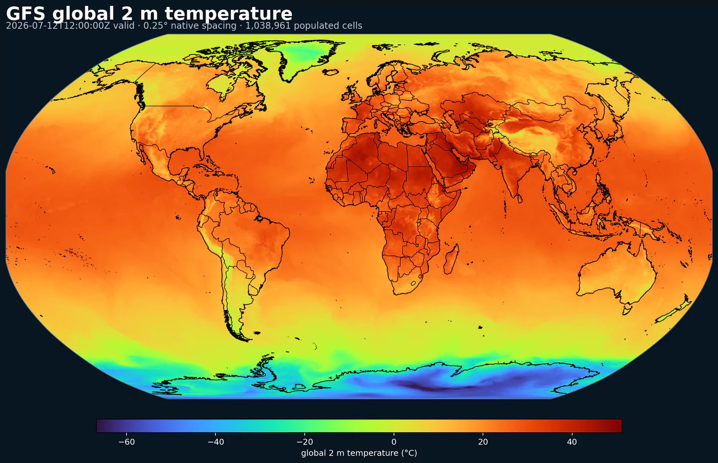
ECMWF Réanalyse v5 (ERA5)

Code GribStream: era5

Disponibilité au lancement : ERA5 est lancé dans GribStream avec une couverture depuis le 1er janvier 2020. Les années antérieures pourront être ajoutées ensuite, et la fenêtre affichée par le catalogue/API reste la référence pendant l'avancement de la charge historique.

Note ERA5T : GribStream considère actuellement les dates antérieures au 1er avril 2026 comme ERA5 final. Les dates plus récentes peuvent encore être ERA5T, la version préliminaire proche du temps réel, jusqu'à leur finalisation et remplacement par ECMWF/Copernicus.

Description

ERA5 est la cinquième génération de réanalyse mondiale de l'ECMWF, produite pour le Copernicus Climate Change Service. La source officielle couvre la période de janvier 1940 à aujourd'hui avec des estimations horaires de l'atmosphère, de la surface terrestre et d'autres variables climatiques.

Son intérêt scientifique est de réanalyser le passé avec un système de modèle et d'assimilation fixe. Les observations sont combinées à la physique du modèle pour créer des champs complets sur grille, plus homogènes qu'une série issue de plusieurs générations de systèmes opérationnels.

ERA5 ne remplace pas une station météorologique ponctuelle. C'est une référence spatiale complète pour la vérification et l'analyse, avec une prudence particulière pour les dates récentes qui peuvent d'abord être diffusées en ERA5T avant d'être finalisées.

Dans GribStream, era5 est exposé comme valeurs réelles par heure valide : forecasted_at et forecasted_time correspondent à la même heure, avec horizon = 0 et member = 0. Vous gardez ainsi la même structure d'API que pour les datasets de prévision.

Certains champs cumulés ou de flux ERA5, comme les précipitations et le rayonnement, proviennent de pas de prévision courts dans l'archive source ECMWF. GribStream conserve les shortNames ECMWF et expose chaque champ par son heure valide, ce qui facilite la jointure avec les prévisions sans modifier la sémantique du paramètre.

La première copie utilise des fichiers GRIB2 séparés par variable pour une sélection centrale de 17 champs mono-niveau. Cette organisation permet d'ajouter d'autres paramètres ERA5 sans casser les sélecteurs existants ni réécrire les index déjà publiés.

ERA5 complète naturellement IFS Oper, IFS ENS et AIFS Oper lorsque vous voulez comparer des prévisions à une référence historique cohérente.

Détails

Datasets liés

Paramètres

0 paramètres

Cliquez sur un paramètre pour voir ses variantes dans une table compacte avec des sélecteurs JSON prêts à copier. Les codes, niveaux et valeurs de sélecteur restent exactement tels que l'API les expose.

100u 100 metre U wind component (m s-1)
1 variant

Parameter ID 228246

ECMWF param DB

Eastward component of the 100 m wind, describing near-surface flow aloft.

  • Comparisons to observations require care because observations represent point measurements rather than grid-box means.
  • Combine with the 100 m V component to derive wind speed and direction.
Level Info Horizon Introduced Selector
sfc 0h 2020-01-01
{"name":"100u","level":"sfc","info":""}
100v 100 metre V wind component (m s-1)
1 variant

Parameter ID 228247

ECMWF param DB

Northward component of the 100 m wind, describing near-surface flow aloft.

  • Comparisons to observations require care because observations represent point measurements rather than grid-box means.
  • Combine with the 100 m U component to derive wind speed and direction.
Level Info Horizon Introduced Selector
sfc 0h 2020-01-01
{"name":"100v","level":"sfc","info":""}
10u 10 metre U wind component (m s-1)
1 variant

Parameter ID 165

ECMWF param DB

Eastward (U) component of near-surface wind.

  • Combine with the 10 m V component to derive wind speed and direction.
  • Observations can diverge due to terrain, vegetation, and local exposure.
Level Info Horizon Introduced Selector
sfc 0h 2020-01-01
{"name":"10u","level":"sfc","info":""}
10v 10 metre V wind component (m s-1)
1 variant

Parameter ID 166

ECMWF param DB

Northward (V) component of near-surface wind.

  • Combine with the 10 m U component to derive wind speed and direction.
  • Observations can diverge due to terrain, vegetation, and local exposure.
Level Info Horizon Introduced Selector
sfc 0h 2020-01-01
{"name":"10v","level":"sfc","info":""}
2d 2 metre dewpoint temperature (K)
1 variant

Parameter ID 168

ECMWF param DB

Dewpoint temperature describing near-surface moisture conditions. Useful for humidity diagnostics.

  • Often combined with temperature and pressure to estimate relative humidity.
  • Computed by interpolating between the lowest model level and the surface.
Level Info Horizon Introduced Selector
sfc 0h 2020-01-01
{"name":"2d","level":"sfc","info":""}
2t 2 metre temperature (K)
1 variant

Parameter ID 167

ECMWF param DB

Near-surface air temperature representative of conditions over land, sea, or inland waters. Derived using surface and lowest model level information.

  • Units are kelvin (K); to convert to degrees Celsius (deg C), subtract 273.15.
  • Mean 2 metre temperature is encoded separately (parameter 228004).
Level Info Horizon Introduced Selector
sfc 0h 2020-01-01
{"name":"2t","level":"sfc","info":""}
msl Mean sea level pressure (Pa)
1 variant

Parameter ID 151

ECMWF param DB

Atmospheric pressure adjusted to mean sea level, reflecting the weight of the air column.

  • Maps of mean sea level pressure highlight cyclones, anticyclones, and wind strength via contour spacing.
  • Often expressed in hPa or millibars (1 hPa = 1 mb = 100 Pa).
Level Info Horizon Introduced Selector
sfc 0h 2020-01-01
{"name":"msl","level":"sfc","info":""}
sd Snow depth (m of water equivalent)
1 variant

Parameter ID 141

ECMWF param DB

Depth of snow expressed as the equivalent depth of water if the snow melted.

  • Represents snow over the snow-covered part of the grid box.
  • See parameter 228141 for the equivalent value expressed in kg m-2.
Level Info Horizon Introduced Selector
sfc 0h 2020-01-01
{"name":"sd","level":"sfc","info":""}
sf Snowfall (m of water equivalent)
1 variant

Parameter ID 144

ECMWF param DB

Accumulated snowfall at the surface (large-scale + convective).

  • Accumulated over the extraction period; depth in metres of water equivalent.
  • See parameter 228144 for the equivalent value expressed in kg m-2.
Level Info Horizon Introduced Selector
sfc 0h 2020-01-01
{"name":"sf","level":"sfc","info":""}
skt Skin temperature (K)
1 variant

Parameter ID 235

ECMWF param DB

Temperature of the Earth's surface required to satisfy the surface energy balance.

  • Represents the uppermost surface layer with no heat capacity, so it responds instantly to surface flux changes.
  • Computed differently over land and sea.
  • Units are kelvin (K); to convert to degrees Celsius (deg C), subtract 273.15.
  • Mean skin temperature is encoded separately (parameter 235079).
Level Info Horizon Introduced Selector
sfc 0h 2020-01-01
{"name":"skt","level":"sfc","info":""}
sp Surface pressure (Pa)
1 variant

Parameter ID 134

ECMWF param DB

Atmospheric pressure at the surface of land, sea, and inland water.

  • Often used with temperature to estimate air density.
  • Mean sea level pressure is typically preferred for identifying large-scale pressure systems in mountainous regions.
  • Often expressed in hPa or millibars (1 hPa = 1 mb = 100 Pa).
Level Info Horizon Introduced Selector
sfc 0h 2020-01-01
{"name":"sp","level":"sfc","info":""}
ssrd Surface short-wave (solar) radiation downwards (J m-2)
1 variant

Parameter ID 169

ECMWF param DB

Downward shortwave radiation at the surface (direct + diffuse).

  • Approximate model equivalent of pyranometer measurements.
  • Accumulated over the extraction period; divide by seconds to convert to W m-2.
  • ECMWF convention for vertical fluxes is positive downward.
Level Info Horizon Introduced Selector
sfc 0h 2020-01-01
{"name":"ssrd","level":"sfc","info":""}
strd Surface long-wave (thermal) radiation downwards (J m-2)
1 variant

Parameter ID 175

ECMWF param DB

Downward longwave radiation at the surface emitted by the atmosphere and clouds.

  • Accumulated over the extraction period; divide by seconds to convert to W m-2.
  • ECMWF convention for vertical fluxes is positive downward.
Level Info Horizon Introduced Selector
sfc 0h 2020-01-01
{"name":"strd","level":"sfc","info":""}
tcc Total cloud cover ((0 - 1))
1 variant

Parameter ID 164

ECMWF param DB

Fraction of a grid box covered by cloud across all model levels.

  • Computed from cloud across different heights with overlap assumptions.
  • See parameter 228164 for the equivalent value in percent.
Level Info Horizon Introduced Selector
sfc 0h 2020-01-01
{"name":"tcc","level":"sfc","info":""}
tcw Total column water (kg m-2)
1 variant

Parameter ID 136

ECMWF param DB

Total column water including vapour, liquid water, cloud ice, rain, and snow.

  • Older IFS versions did not include rain and snow in the total.
Level Info Horizon Introduced Selector
sfc 0h 2020-01-01
{"name":"tcw","level":"sfc","info":""}
tcwv Total column vertically-integrated water vapour (kg m-2)
1 variant

Parameter ID 137

ECMWF param DB

Total water vapour in a column from the surface to the top of the atmosphere.

  • Represents a grid-box mean value.
Level Info Horizon Introduced Selector
sfc 0h 2020-01-01
{"name":"tcwv","level":"sfc","info":""}
tp Total precipitation (m)
1 variant

Parameter ID 228

ECMWF param DB

Accumulated rain + snow at the surface (large-scale + convective).

  • Does not include fog, dew, or precipitation that evaporates before reaching the surface.
  • Accumulated over the extraction period; depth in metres of water equivalent.
  • See parameter 228228 for the equivalent value expressed in kg m-2.
Level Info Horizon Introduced Selector
sfc 0h 2020-01-01
{"name":"tp","level":"sfc","info":""}

Aucun paramètre ne correspond à la recherche.